Report to/Rapport au:
Transportation and Transit Committee/
Comité des transports et des
services de transport en commun
and Council/et au Conseil
18 October 2001 / le 18
octobre 2001
Submitted by/Soumis
par: Ned Lathrop, General Manager/Directeur général
Development Services Department
/ Services d’aménagement
Contact/Personne-ressource: Vivi Chi, Manager, Transportation and
Infrastructure Gestionnaire, transports et l’infrastructure
580-2424,
ext. 21877, vivi.chi@city.ottawa.on.ca
|
|
|
Ref N°: ACS2001-DEV-POL-0035 |
SUBJECT: INNES ROAD WIDENING (417 TO BLAIR; ORLÉANS
BLVD TO TRIM ROAD) ENVIRONMENTAL ASSESSMENT STUDY
OBJET: ÉLARGISSEMENT DU CHEMIN INNES (DE LA
417 AU CHEMIN BLAIR; DU BOUL. ORLÉANS AU CHEMIN TRIM) ÉTUDE D’ÉVALUATION
ENVIRONNEMENTALE
REPORT RECOMMENDATIONS
That the Transportation and Transit Committee recommend Council
approve:
1.
Modifications to
Innes Road from Highway 417 east to Blair Road including the provision of
sidewalks, bicycle lanes, noise attenuation, and an additional traffic lane in
each direction.
2.
Upgrading of Innes
Road from Orléans Boulevard east to Trim Road from a two-lane road to a
four-lane divided urban arterial including the provision of sidewalks, bicycle
lanes, noise attenuation, landscaping, lighting, and traffic control.
3.
The preparation and
filing of an Environmental Study Report (ESR) for the above-noted modifications
to Innes Road.
4.
The inclusion of
the identified unequal widening requirements for the section of Innes Road east
of Orléans Boulevard in the appropriate schedule(s) of the new City of Ottawa
Official Plan.
RECOMMANDATIONS DU RAPPORT
Que le Comité des
transports et des services de transport en commun recommande au Conseil
municipal d’approuver :
1.
des modifications au chemin Innes
depuis l’autoroute 417 à l’est jusqu’au chemin Blair, notamment l’aménagement
de trottoirs, de bandes cyclables, de dispositifs de réduction du bruit et
d’une voie de circulation additionnelle dans chaque direction;
2.
la réfection du chemin Innes depuis
le boulevard Orléans à l’est jusqu’au chemin Trim, soit le réaménagement du
chemin à deux voies en une artère à chaussées séparées à quatre voies, la
construction de trottoirs, de bandes cyclables, de dispositifs de réduction du
bruit, d’éclairage et de signalisation routière ainsi que des travaux
d’aménagement paysager;
3.
l’élaboration et la présentation
d’un rapport d’étude environnementale pour les modifications précitées au
chemin Innes;
4.
l’ajout de critères d’élargissement
identifiés pour le tronçon du chemin Innes à l’est du boulevard Orléans dans
les annexes appropriées du Plan directeur de la nouvelle Ville d’Ottawa.
BACKGROUND
The Regional Official Plan (ROP) and the Transportation Master Plan (TMP) identified a number of transportation projects related to projected population and employment growth and consequent east-west travel demand in the East Urban Community (Orléans).
Included in the list of major transportation project needs are:
· the Cumberland Transitway;
· the Blackburn Hamlet Bypass Extension;
· the widening of Innes Road.
While the first two projects were identified for implementation beyond the year 2006, the upgrading of Innes Road was identified as a higher priority with implementation scheduled between 2001 and 2006 (Table 6, ROP).
In July 1997, Regional Council approved the undertaking of the Environmental Assessments (EA) for the Cumberland Transitway and Blackburn Hamlet Bypass Extension projects. It was necessary to establish the transitway and roadway alignments and right-of-way requirements at the earliest possible date in order to allow land planning and development to proceed and the appropriate future corridors to be protected. Council approved these two EAs in March 1999, which were subsequently approved by the Ministry of the Environment.
Need
While the ROP had identified upgrading Innes Road as a “second priority” project for implementation within the period 2001-2006, a report to Regional Council in September 2000 entitled “Growth in Ottawa-Carleton, 1996-1999 and Infrastructure Plans” confirmed that urban growth in the East Urban Community (Orléans) was at a pace to surpass the ROP’s anticipated growth by 2006. Thus the need for upgrading the two sections of Innes Road was reconfirmed.
The ROP projected the East Urban Community (Orléans) to grow to a level of 29,000 dwelling units (d.u.) by 2006, and to 38,000 d.u. by 2021 with corresponding levels of employment, retail, and other services in accordance with the ROP’s objectives and policies. The growth-monitoring report (referred to above) confirmed that Orléans was growing as anticipated and was the only urban community exceeding the targets previously established in 1997. With the ongoing rapid residential growth along both sides of Innes Road through Orléans, and with the amount of new retail and institutional growth on lands fronting directly onto Innes Road, there has been a significant increase in travel demands by all modes along and across the Innes Road corridor.
West of Blair Road, where Innes Road/Blackburn Hamlet Bypass reduces from six lanes to four lanes, a combination of the urban growth to the east along with major “big box” development on the south side of Innes (Costco, Canril, etc.) and in the Cyrville Road corridor (Home Depot, Lazy Boy, etc.) has led to severe congestion at this time on this section of Innes Road, with considerable delays for all road users.
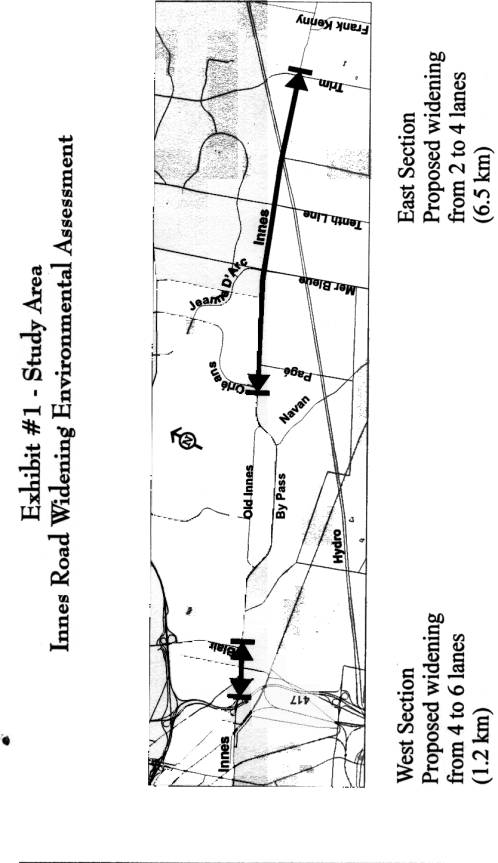
In September 1999, the Environmental Assessment for the widening of Innes Road (Highway 417 to Blair Road, and Orléans Boulevard to Trim Road) was initiated. The study area is illustrated in Exhibit 1.
DISCUSSION
Existing Conditions
The current four-lane section of Innes Road from Highway 417 east to Blair Road is operating at, or near, capacity during peak periods. Both commuter and adjacent retail-related traffic volumes are increasing rapidly, bicycles are not appropriately accommodated, and some of the adjacent residential developments require noise attenuation from the increasing traffic.
The current two-lane rural section of Innes Road from Orléans Boulevard east to Trim Road is also operating at, or near, capacity during peak periods. There are no sidewalks, and bicycles are accommodated on the road’s shoulders adjacent to the ditches. There are also many operational and safety problems due to the number of uncontrolled driveways and private approaches.
Confirmation of Alternative
Solutions
The ROP and TMP had established that the provision of transportation service in the East Urban Community (Orléans) would require the development of rapid transit in two corridors (Highway 174, and the Cumberland Transitway corridor south of Innes Road), as well as the upgrading of existing road corridors such as Innes Road and Regional Road 174, and the provision of new road corridors such as the Innes-Walkley link.
These new pieces of transportation infrastructure coupled with the achievement of all the other related objectives of the ROP (pertaining to job creation within urban communities, travel demand management (TDM), increases in the walking, cycling and transit share of trip making, increased vehicle occupancy and network efficiency) will enable the transportation needs of the East Urban Community to be met with an acceptable quality of service during peak periods.
The Innes Road EA has reconfirmed the upgrading of Innes Road, including the provision of six through lanes west of Blair Road and four lanes east of Orléans Boulevard, to be essential requirements, if the ROP is to be implemented as approved in 1997 and in order for the East Urban Community to be provided with the necessary transportation facilities.
Design Criteria
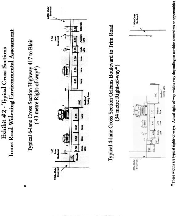
Key design criteria used as a baseline in the development of alternatives include:
- 70 km/h design speed (60 km/h posted speed)
- 2.0m
cycling lanes
- 3.5m traffic
lanes
- 3.0m
boulevards
- 5.0m median (includes left-turn lane)
- 2.0m sidewalks
For the section of Innes Road from Highway 417 to Blair Road, these criteria had to be modified somewhat due to right-of-way constraints. Typical cross-sections are illustrated in Exhibit 2.
Alternative Design Concepts
Highway 417 to Blair Road
Over this section, the existing right-of-way limit of the north side was taken as a given with the future widening needs confined to the south side where development was to occur. Three alternatives were developed, with the differences being dictated by the start and end points and the radius of the horizontal curve that could be developed between Cyrville Road and Highway 417.
Orléans Boulevard to Trim Road
The existing right-of-way is too narrow in some sections to accommodate the roadway upgrade. There is a need to acquire land. There was an initial development of three distinct alignment alternatives:
- equal widening on either side of the existing centreline;
- an unequal widening (a shifted right-of-way) for a part of the route in order to minimize property impact and improve roadway geometry; and
- undivided roadway (no median) for a part of the route.
As the development of an alignment using a design without a central median would not be in accordance with previous planning carried out by the City of Cumberland and would also not conform to Regional Arterial Standards, the third option was discarded as a stand-alone alternative although elements of it were carried forward in further refinements of the two other alternatives.
The alignment alternatives were evaluated and presented to the Technical Advisory Committee and to the Focus Groups, and were presented at public Open Houses. Refinements were made based on the comments received.
Major Issues
Noise
There will be increased levels of ambient noise as a result of the roadway upgrade. Noise barriers will be erected at appropriate locations. There were questions about the design and materials to be used for the barriers. Although this is a detailed design issue that is not usually addressed in an Environmental Assessment study, samples of existing noise wall designs were presented to the Focus Groups and at the Open Houses.
Access To/From Innes
The development of a divided roadway does impose some access restrictions resulting in right-in/right-out only movements. One of the townhome developments on the northside (east of Stonehenge East) will lose its current full movement access, as will a number of properties in the section between Orléans Boulevard and Trim Road – they will be limited to right-in/right-out only. Full access will be provided where possible and safe to do so.
There had been some discussion with regard to the possible closure of Pagé Road at Innes Road. However, with the planned extension of Orléans Boulevard to Navan Road and with the planned closure of Pagé Road at the future Cumberland Transitway, there was no traffic-related need to close Pagé Road at Innes Road at this time. Traffic signals are proposed at this location to address any safety/operational issues.
Traffic Signals at Intersections
There have been numerous requests made by the public to have most intersections east of Orléans Boulevard signalized. With increasing development occurring on the south side of Innes Road requiring both access to Innes Road and generating more traffic, it is likely that signals at most major intersecting streets will be warranted soon.
Private Wells
Some properties towards the eastern end of the corridor rely on private wells. The road widening may compromise the viability of these private services. The future road widening and on-going area development, however, will allow for the provision of municipal services to these homes. The cost of connecting to municipal services will be resolved at the time of property acquisition/negotiations.
Property Impacts
For the western portion (Highway 417 to Blair Road), there are no affects on the properties along the north edge of Innes Road. The future right-of-way requirements will be accommodated on the south side where commercial development is taking place. Even with the shifting of the alignment between Orléans Boulevard and Trim Road, there will be a number of properties that will be affected by the roadway upgrade. The required right-of-way across land being developed will be acquired through the development approvals process as permitted by the Planning Act. Other sites will have to be acquired by the City in accordance with established procedures.
Support for the Project
There is an overwhelming desire from the public to have Innes Road widened as soon as possible. Safety issues will be addressed with the roadway upgrade, as will road capacity requirements. The urban arterial road design will improve the visual aspect and introduce new amenities to the corridor (sidewalks, bicycle lanes, noise walls, curbs, lighting).
Recommended Design
The recommended design for Innes Road widening is illustrated in the numerous panels included as Exhibits 3 and 4.
ENVIRONMENTAL IMPLICATIONS
As this is an Environmental Assessment study, the affects on the environments (social, physical, biological, transportation) were comprehensively evaluated. The most notable effects will be the need to acquire property for the right-of-way and the increase in traffic noise. Several individual dwellings and small businesses will be displaced. Others will have their access restricted because of the widening and related operational safety issues. Noise barriers will be constructed to mitigate the increase in noise levels. The reconstruction of Innes Road will, however, provide additional amenities such as sidewalks, cycle lanes, and street lighting as well as alleviate existing traffic congestion.
CONSULTATION
The Innes Road project is being carried out in accordance with the Municipal Engineer’s Association Class Environmental Assessment Process for Municipal Road Projects (1993) as a Schedule C project. During the course of the study, regular update meetings were held with the Technical Advisory Committee (TAC) and organized Focus Groups to seek input, direction, and concurrence on the study findings and recommendations.
TAC was composed of representatives from the City (former Region, Gloucester, and Cumberland), OC Transpo, MTO, and the NCC. Review agencies and authorities not represented on TAC were also invited to provide technical assistance when warranted. Cycling issues were addressed during the EA process by input from the former Transportation Department (Mobility Services). Further cycling input from the new Cycling Advisory Committee will be sought at the time of detailed design.
Focus Group meetings were held with individuals and small groups immediately affected by the proposed widening. To ensure effective consultation, stakeholders were brought together by geographical sector. The study area was broken down into six focus group areas and two sets of focus group meetings (10 total) were carried out at the appropriate times during the study.
In addition to the Focus Group meetings, two Open Houses were conducted to present the study and its findings to the general public. The first of these was held on 25 May 2000 at which the study process, existing conditions, alignment options, assessment process, issues and next steps were presented for public review and comment. The second and final Open House, held on 11 April 2001, presented the environmental impact assessment and the technically preferred alternative for each section of Innes Road.
Both Open Houses were advertised in local and community papers. Flyers were distributed to those homes and businesses within the study area boundaries. Both meetings were well attended, with approximately 170 people at the first and second Open Houses. Six roadway signs were also erected at the start of the project to indicate that an environmental assessment study was underway.
FINANCIAL IMPLICATIONS
The preliminary cost estimate to undertake the detailed design, purchase property, and construct the widening of Innes Road is approximately $47 million (in 2001 dollars). A more accurate total project cost will be developed as detailed design is undertaken.
Some funds for design have already been approved in 2001 and are shown in the capital account 900428 Innes Road (Highway 417 to Blair Road; Orléans Boulevard to Trim Road). The balance of the project cost estimate will be identified in the 2002 capital budget submission.
ATTACHMENTS
Exhibit 1 – Study Area (Description (html) and link to Exhibit (pdf).
Exhibit 2 – Typical Cross-Sections (Description (html) and link to Exhibit (pdf).
Exhibit 3 – Recommended Design (Innes Road – Highway 417 to Blair Road) (Description (html) and links to Exhibits (pdf).
Exhibit 4 – Recommended Design (Innes Road – Orléans Boulevard to Trim Road) (Description (html) and links to Exhibits (pdf).
DISPOSITION
The Environmental Study Report (ESR) which documents the entire environmental assessment process and study recommendations will be prepared and filed for the 30-day public review period, in accordance with the provincial Environmental Assessment Act.
Once the formal review period is over, and if there are no “bump-up” requests to the Minister of the Environment, the project will be considered approved. Detailed design can then be initiated.
The unequal widening requirements for the section of Innes Road east of Orléans Boulevard will be included in the appropriate schedule(s) of the new City of Ottawa Official Plan.