Report to/Rapport au :
Comité des transports
and Council / et au Conseil
28 June 2005 / le 28 juin 2005
Submitted by/Soumis par : Ned Lathrop, Deputy City Manager/Directeur
municipal adjoint,
Planning and Growth Management/Urbanisme et Gestion de la croissance
Contact
Person/Personne ressource : Peter Steacy, Program Manager Transportation -
Environmental Assessments
Planning, Environment and Infrastructure
Policy/Politiques d’urbanisme, d’environnement et d’infrastructure
(613) 580-2424 x 21827, peter.steacy@ottawa.ca
REPORT RECOMMENDATIONS
That the
Transportation Committee recommend Council approve:
1)
the Environmental Assessment
study’s recommended plan for the North-South Corridor Light Rail Transit
Project, enabling the procurement process to advance;
2)
finalizing the Environmental
Assessment Report and posting the Notice of Study Completion, thereby
commencing the Ontario Ministry of the Environment approval process; and
3)
initiating the property
acquisition process for all property interests required for the construction of
the North-South Corridor Light Rail Transit Project, including expropriation if
necessary, as set out in this report.
Note: The findings and recommendations in this report encompass all
aspects of the full North-South Light Rail Transit Corridor envisioned for
2021. Some of these recommendations do not factor in the planned North-South
Light Rail Transit project slated for completion in 2009. Where possible within
this report, the distinction is made between the full Corridor and the
recommended 2009 project scope.
RECOMMANDATIONS DU
RAPPORT
Que le Comité des transports recommande au Conseil
d'approuver :
1) le
plan recommandé dans l'Étude d'évaluation environnementale pour le projet du
tronçon nord-sud du train léger sur rail, autorisant l'amorce du processus
d'approvisionnement;
2) la
complétion du Rapport d'évaluation environnementale et la publication de l'avis
d'achèvement de l'étude, ce qui enclenchera le processus d'approbation du
ministère de l'Environnement de l'Ontario;
3) l'amorce
du processus d'acquisition de tous les intérêts de propriété nécessaires à la
construction du Tronçon nord-sud du train léger, y compris l'expropriation au
besoin, tel que décrit dans le rapport;
Remarque : Les conclusions et les
recommandations du rapport englobent tous les aspects de l’ensemble du tronçon
nord-sud du train léger envisagé pour 2021. Certaines de ces recommandations ne
tiennent pas compte du projet de couloir nord-sud de train léger sur rail, dont
l’achèvement est prévu pour 2009. Chaque fois que cela est possible, le rapport
fait la distinction entre le tronçon complet et les recommandations relatives à
la portée du projet de 2009.
EXECUTIVE SUMMARY
Assumptions
and Analysis:
In April 2004, the City of Ottawa initiated an Environmental Assessment (EA) study for the North-South Light Rail Transit Corridor to address existing and future transportation demand between the rapidly growing communities in the south and downtown Ottawa, as well as points in between including the Macdonald-Cartier International Airport. The EA process engages residents and businesses to examine a wide range of alternatives, identifying both construction and operational impacts on all aspects of the environment – such as transportation, nature, socio-economic, and cultural – and brings forward a recommended plan for construction of the project.
This report outlines the study findings and presents the final recommended plan for the North-South Corridor Light Rail Transit Project. Committee and Council are being asked to approve the recommended alignment (route); technology choice; station and Park & Ride lot locations and preliminary layouts; grade separations (bridges, culverts and tunnels); proposed maintenance and storage yard locations; and all other supporting infrastructure (including vehicles) required for this project. Project capital and operating costs, property requirements and a suggested phasing plan are also presented for approval, together with an outline of the study process, a discussion of issues, and the study consultation program.
This project is the critical first step towards implementing Light Rail Transit as part of the overall expansion of the City’s rapid transit network, which is a fundamental requirement of the City’s Official Plan (OP) and Transportation Master Plan (TMP). It delivers on several key Smart-Growth objectives, including providing high-quality rapid transit services early in the development of major growth areas, thereby setting the stage for attaining the City’s long-range objectives of increasing the share of peak-hour travel from 17% transit ridership now to 30% transit ridership by 2021.
The North-South Light Rail Transit Corridor is expected to deliver a number of benefits, including:
· environmental benefits: cleaner air by reducing greenhouse gas emissions from the burning of fossil fuels through the replacement of current diesel technology with electric power, as well as by the proven success of Light Rail in converting more residents from using cars to choosing transit;
· reduced traffic congestion: reducing the number of cars on parallel roads, increasing the current reductions of over 600 fewer cars on Bronson Avenue and other roads as a result of the O-Train Pilot Project;
· social benefits: connecting communities and fostering travel and participation between communities, as well as offering more housing options for the city’s university students along the Light Rail line;
· economic benefits: providing new opportunities for residents and visitors to access downtown businesses, shops and entertainment districts, especially on weekends and in off-peak hours; enabling some residents to reduce expenses related to the number of family vehicles owned; and enabling the City of Ottawa to achieve significant cost efficiencies in the operational costs of transit services delivery.
The recommended Corridor plan consists of 31 km of twin-track electrically powered Light Rail Transit service running from its southern terminus (end point) in the future Barrhaven Town Centre to the Rideau Centre, and includes a link to the Macdonald-Cartier International Airport. By 2021, a projected ridership of 60,000 to 70,000 people per weekday will be served on the North-South Light Rail Transit line, accessed at up to thirty-five different station locations. Four new Park & Ride lots, with a potential total collective capacity of over 7000 parking spots, have been planned at Leitrim, Bowesville, River Road and Woodroffe stations.
The selected route is centred on the expansion of the existing O-Train Pilot Project (former CP Ellwood) corridor, with a southern and western extension through Riverside South to Barrhaven Town Centre, and an eastern extension through LeBreton Flats, up the escarpment sharing the bus transit lanes along Albert and Slater Streets to a terminus at the Rideau Centre on the Mackenzie King Bridge. Alignments and station locations through Barrhaven and Riverside South were determined through separate community planning processes, with refinements made through the EA. The alignment through LeBreton Flats was developed in close cooperation with the National Capital Commission.
The recommended route contained in this report reflects intensive consultation with businesses, property owners and tenants in the downtown core along both Albert and Slater Streets. As part of this Environmental Assessment, the study team has communicated with virtually all of the approximately 131 businesses on Albert and Slater Streets to gather input on options for the line through the downtown core.
The meetings and input from these businesses has provided some excellent recommendations for revisions to initial plans. Consequently, many changes were made to the initial Light Rail option, including:
- The downtown Light Rail Transit lanes, which were initially planned to be on the opposite side of the street from the Bus Rapid Transit lane on both Albert and Slater Streets, was moved to provide a combined Light Rail/bus lane where the current bus lane exists today.
- More parking spaces were retained on both streets.
- Special loading areas were added or strengthened to enable loading of people and delivery of goods.
- Light Rail platforms, which were initially on the same block as bus stops on Albert and Slater, have been moved to every second block and placed on the same side of the street as the bus stops to alleviate potential congestion between buses and Light Rail vehicles.
- Street improvement details were added, including textured sidewalks and the addition of trees where it makes sense to improve the pedestrian environment and aesthetics of both streets.
- Better turning lanes for motorists were created.
- In some cases, sidewalks were widened to accommodate the straight line of the Light Rail’s steel rails in the roadbed, providing more space on the sidewalks for pedestrians, trees or street furniture.
Significant concern was also expressed during these consultations about the ability of Albert and Slater to accommodate the addition of Light Rail vehicles with the current bus volume, especially during peak hours. Transit Services has committed to reducing the number of buses on Albert and Slater, with initial bus reductions projected at up to 25% by 2009. A detailed assessment of route changes and other mechanisms to accomplish this reduction will be completed later this year.
The North-South Light Rail Transit line crosses the Rideau River on new bridges at two locations; in the south connecting Barrhaven and Riverside South communities via the Strandherd-Armstrong train/car bridge, and midway along the north-south portion of the line between Vincent Massey Park and the campus of Carleton University. Bridges will carry the tracks over the existing CN freight and Via passenger rail corridors, and the existing single-track tunnel under the Rideau Canal just west of Dow’s Lake will be twinned. Seven additional bridges will be required at various points along the line.
The electrical power supply infrastructure will consist of overhead wires supported by poles, fed by 18 electrical sub-stations located at strategic points along the line. Several existing underground utilities will be relocated, and some existing water mains and sewers will be rehabilitated or replaced where warranted.
The proposed plan identifies three potential maintenance and storage yard facility locations for approval. The final location for the yard will be subject to property negotiations, with a recommendation to be brought forward separately to the City’s Corporate Services and Economic Development Committee for approval.
Once approved by Committee and Council, the EA will be submitted to Ontario’s Ministry of the Environment (MOE) for its public review process and approval, as well as to the Canadian Environmental Assessment Agency. Simultaneously, the City’s Light Rail Office will advance on the private-sector partner selection process for the construction of the North-South line, designated properties will be acquired.
Financial
Implications:
The approval being sought through the EA process is for the full build-out (2021) project. This includes 44 vehicles, 34 stations, and 4 new Park & Ride lots. The estimated cost for this project is $950 million (2005 dollars).
The suggested first phase project (2009) extends from the Rideau Centre in the north to Woodroffe Station in the south, but does not include the connection to the Airport. A maintenance facility is included, as well as 21 vehicles, 18 stations, and 3 new Park & Ride lots.
Subject to further assessment and detailing of the design work, the estimate for the Phase 1 Project falls within the City’s long range budgeted plan of $725 million.
Public
Consultation/Input:
Extensive consultation was undertaken over the course of the study, through Consultation Group meetings, Public Open Houses, and meetings and correspondence with project stakeholders and interested individuals and groups. The public was also able to access study information and correspond by e-mail through the project Web site.
Since the plan for Light Rail Transit through the downtown core created the greatest public interest, a focused consultation effort was also undertaken to inform and obtain input from the affected stakeholders. Through direct consultation with businesses, property owners and tenants on Albert and Slater Streets, a workable solution integrating Light Rail Transit and bus transit operations into shared lanes was developed, similar to the Light Rail solution used by Portland, Oregon. There have also been many inquiries about the feasibility of a downtown tunnel. The EA does not recommend a tunnel, as it is not an affordable option at this time. The preferred plan does not preclude this option for the future, and recommends the protection by the City of key tunnel access points for a future tunnel.
In summary, the results of the public consultation indicated overall strong and clear support for North-South Corridor Light Rail Project, with the majority of the feedback revolving around project timing and costs and many residents eager for Light Rail to arrive in their neighbourhoods. Public consultation provided valuable input and led to several important enhancements and modifications to the recommended plan presented herein.
RÉSUMÉ
Hypothèses
et analyse :
En avril 2004, la Ville d'Ottawa a amorcé une étude
d'évaluation environnementale (EEE) concernant le projet d'établir un tronçon
nord-sud du train léger sur rail, devant répondre à la demande actuelle et
future de transport entre les collectivités en plein essor du secteur sud, le
centre-ville d'Ottawa et les points intermédiaires, comme l'Aéroport
international Macdonald-Cartier. L'étude d'évaluation environnementale invite
les résidents et les entreprises à examiner une variété d'options, détermine
les impacts qu'occasionnent les activités de construction et d'exploitation sur
tous les aspects de l'environnement, tels que transports, nature, aspects
socioéconomiques et culturels, etc., et recommande un plan de contruction pour
le projet.
Le rapport expose les conclusions de
l'étude ainsi que le plan final recommandé pour le Projet du train léger
nord-sud. Le Comité et le Conseil sont invités à approuver le tracé (circuit)
recommandé, les choix technologiques, l'emplacement des stations et des
parcs-o-bus et les parcours préliminaires, les ouvrages de franchissement
(ponts, ponceaux et tunnels), l'emplacement proposé des installations
d'entretien et de remisage et toutes les autres infrastructures de soutien (y
compris les véhicules) nécessaires au projet. Les coûts d'immobilisations et
d'exploitation, les besoins en biens fonciers et un plan d'échelonnement
suggéré sont aussi présentés pour approbation, de même qu'un schéma d'exécution
de l'étude, un examen des questions soulevées ainsi que le processus
consultatif de l'étude.
Ce projet représente une première étape
cruciale dans l'établissement du train léger sur rail, dans le contexte de
l'expansion générale du réseau de transport rapide de la Ville, exigence
fondamentale du Plan officiel de la Ville et du Plan directeur des transports.
Il fait suite à diverses orientations du Programme de croissance intelligente,
dont celui d'offrir des services de transports en commun rapides tôt
dans le développement des principales zones de croissance, ouvrant ainsi la
voie à la réalisation des objectifs à long terme de la Ville d'accroître la
part d'utilisation des transports en commun en période de pointe de 17 à 30
pour cent d'ici 2021.
On prévoit que le Tronçon nord-sud du
train léger procurera divers avantages, notamment :
·
avantages
environnementaux : assainissement de l'air grâce à la réduction des
émissions de gaz à effet de serre produites par la combustion de carburants
fossiles; cet avantage est obtenu grâce au remplacement de la technologie
diesel par l'électricité et à la capacité démontrée du train léger d'inciter
les gens à délaisser l'automobile au profit des transports en commun;
·
réduction de
la congestion : diminution du nombre d'automobiles sur les voies
parallèles, réduction additionnelle de plus de 600 automobiles sur l'avenue
Bronson et d'autres routes à la suite du projet pilote de l'O-train;
·
bienfaits
sociaux : interconnexion entre les collectivités et promotion des déplacements
et de la collaboration entre les collectivités, et plus d'options de logement
pour les universitaires le long de la ligne du train léger;
·
bienfaits
économiques : nouvelles possibilités pour les résidents et les visiteurs de se
rendre aux entreprises, aux boutiques et aux secteurs de divertissement du
centre-ville, surtout durant les fins de semaine et en heures creuses; occasion
pour certains résidents d'économiser sur le nombre de véhicules par foyer et
possibilité pour la Ville d'Ottawa de réduire considérablement ses coûts
d'exploitation des services de transports en commun.
Le plan recommandé consiste en un tronçon
de 31 km de voies jumelées pour train léger électrique allant du terminus sud,
dans le futur centre-ville de Barrhaven, au Centre Rideau, avec lien vers
l'Aéroport international Macdonald-Cartier. Selon les prévisions, en 2021,
entre 60 000 et 70 000 passagers utiliseront chaque jour de semaine la
ligne nord-sud du train léger à partir des différents points d'accès du réseau,
qui pourra compter jusqu'à 35 stations. Quatre nouveaux terrains de parc-o-bus
pouvant accueillir plus de 7 000 véhicules seront aménagés aux stations
Leitrim, Bowesville, River Road et Woodroffe.
Le circuit choisi s'appuie sur l'expansion
du tronçon établi pour le projet pilote de l'O-Train (ancien couloir du CP à
Ellwood) et prévoit une extension vers le sud et l'ouest par Riverside sud vers
le centre-ville de Barrhaven et une extension vers l'est par les Plaines
LeBreton, le circuit franchissant l'escarpement et empruntant les voies de
transport en autobus le long des rues Albert et Slater, pour aboutir au
terminus du Centre Rideau, pont Mackenzie-King. Le tracé et l'emplacement des
stations dans Barrhaven et Riverside sud ont été déterminés au moyen de
processus de planification communautaire distincts, et affinés lors de
l'exécution de l'étude d'évaluation environnementale. Le tracé des Plaines
LeBreton a été défini en étroite collaboration avec la Commission de la
capitale nationale.
Le circuit recommandé dans le rapport fait
suite à une consultation poussée des entreprises, des propriétaires fonciers et
des locataires du centre-ville, établis le long des rues Albert et Slater. Dans
le cadre de l'étude d'évaluation environnementale, le groupe d'étude a
communiqué avec la presque totalité des quelque 131 entreprises sise sur
les rues Albert et Slater afin de
recueillir des avis sur les différentes options de tracé au centre-ville.
D'excellentes recommandations ont été
formulées lors des réunions avec ces entreprises et ont été intégrées aux plans
initiaux. Par conséquent, de nombreux changements ont été apportés au plan
initial du train léger, entre autres :
- Au centre-ville, les voies du réseau de train
léger, qui devaient se situer du côté opposé du système rapide par bus sur
les rues Albert et Slater, seraient maintenant aménagées de manière à
constituer une voie combinée train léger / autobus là où des voies pour
autobus existent déjà.
- Un plus grand nombre d'espaces de
stationnement ont été conservés sur les deux rues.
- Des aires de chargement spéciales ont été
ajoutées ou renforcées pour permettre l'embarquement des passagers et la
livraison de marchandises.
- Les quais du train léger, initialement
intégrés aux arrêts d'autobus sur les rues Albert et Slater, seront plutôt
placés à tous les deux îlots de maisons, du même côté de rue que les
arrêts d'autobus, afin de réduire le risque de congestion entre les
autobus et les véhicules du train léger.
- Les deux rues seront améliorées par certains
détails comme des trottoirs texturés et la plantation d'arbres là où il
convient d'améliorer l'environnement piétonnier et le caractère esthétique
de la rue.
- Des voies de virage améliorées ont été
prévues.
- Dans certains cas, les trottoirs ont été
élargis pour permettre l'aménagement de la ligne droite des rails du train
léger dans l'assiette de la chaussée, ce qui offre plus d'espace sur les
trottoirs pour le passage des piétons ou l'aménagement d'arbres ou de
mobilier de rue.
La capacité des rues Albert et Slater à
accepter les véhicules du train léger en plus du nombre actuel d'autobus,
surtout aux heures de pointe, a soulevé de nombreuses questions lors des
consultations. Les services de transport en commun se sont engagés à réduire le
nombre d'autobus sur les rues Albert et Slater, la réduction initiale prévue
pouvant atteindre les 25 p. cent d'ici 2009. Une évaluation détaillée des
modifications des circuits et d'autres moyens déployés pour atteindre cet
obiectif sera effectuée plus tard cette année.
Le Tronçon nord-sud du train léger
traverse la rivière Rideau sur de nouveaux ponts à deux endroits : au sud,
entre les collectivités de Barrhaven et de Riverside, par le pont de trains et
d'automobiles de Strandherd-Armstrong, et à mi-chemin le long de la portion
nord-sud de la ligne entre le parc Vincent-Massey et le campus de l'Université
Carleton. Sur les ponts, la voie rejoindra celles du CN (fret) et de VIA
(transport de passagers) et le tunnel à voie unique sous le canal Rideau à
l'ouest de Dows Lake sera doublé. Sept ponts additionnels devront être aménagés
à différents endroits le long de la ligne.
L'infrastructure d'alimentation électrique
sera constituée de caténaires soutenus par des poteaux, alimentés par 18
sous-stations électriques déployées à des endroits stratégiques le long de la
ligne. Plusieurs installations sous-terraines existantes
seront déplacées et certaines conduites principales d'eau et canalisations
d'égout feront l'objet de travaux de réhabilitation ou seront remplacées.
Le plan proposé recommande trois emplacements
d'installations d'entretien ou de remisage, pour approbation. L'emplacement
définitif du lieu de remisage dépendra de l'issue des négociations sur les
biens fonciers, une recommandation distincte devant être faite au Comité des
services organisationnels et du développement économique, pour approbation.
Après l'approbation du Comité et du
Conseil, l'étude d'évaluation environnementale sera présentée au ministère de
l'Environnement de l'Ontario, pour examen public et approbation, et à l'Agence
canadienne d'évaluation environnementale. Parallèlement, le Bureau du transport
en commun par train léger mènera son processus de sélection des partenaires du
secteur privé pour la construction de la ligne nord-sud. De plus, les
propriétés désignées seront acquises.
Répercussions financières :
L’approbation
sollicitée dans le cadre du processus d’évaluation environnementale porte sur
la totalité du projet devant être réalisé d’ici à 2021. Celui-ci prévoit 44
véhicules, 34 stations et 4 nouveaux parc-o-bus. Le coût estimatif du projet
est de 950 millions de dollars (en dollars de 2005).
La première phase proposée (2009) porte sur le tronçon allant du Centre
Rideau, au nord, à la station Woodroffe, au sud, mais ne comprend pas le
raccordement à l’aéroport. Elle prévoit une installation d’entretien ainsi que
21 véhicules, 18 stations et 3 nouveaux parcs-o-bus.
Sous réserve d’une évaluation plus approfondie et de travaux de conception
plus détaillés, le coût estimatif de la phase 1 respecte le plan budgétaire à
long terme de la Ville, qui porte sur 725 millions de dollars
Consultation publique / commentaires :
Tout au long de l’étude, des consultations poussées
ont été menées au moyen d'assemblées, de séances portes ouvertes, de réunions
et d'échange de correspondance avec les parties prenantes du projet ainsi que
les personnes et les groupes intéressés. Le public a pu consulter l'information
relative à l'étude et correspondre par courrier électronique sur le site Web du
projet.
Étant donné que le plan de transport par
train léger au centre-ville a suscité le plus d'intérêt auprès du public, des
efforts de consultation ciblés ont été déployés pour informer les parties
intéressées et recueillir leurs points de vue. Une consultation directe des entreprises,
des propriétaires fonciers et des locataires des rues Albert et Slater a permis
de dégager une solution viable intégrant les opérations du train léger et des
autobus sur des voies communes, semblable à celle qui a été appliquée à
Portland, en Oregon. En outre, la faisabilité d'aménager un tunnel au
centre-ville a suscité beaucoup d'intérêt. L'étude d'évaluation
environnementale ne recommande pas la construction d'un tunnel, puisque cette
option n'est pas abordable pour le moment. Le plan choisi n'exclut pas cette
option pour l'avenir et recommande que la Ville protège les principaux points
d'accès à un éventuel tunnel.
En
résumé, les résultats de la consultation publique indiquent généralement un
appui ferme et clair à l'endroit du projet de tronçon nord-sud du train léger.
La plus grande partie des avis concernaient l’échéancier et les coûts du
projet, de nombreux résidents se disant impatients de bénéficier du service de
train léger dans leur quartier. La consultation publique a permis de recueillir
des avis précieux et a mené à des améliorations et à des modifications
importantes du plan recommandé, présenté dans le rapport.
BACKGROUND
Study Initiation
The City’s 2003 Official Plan (OP) projects a population reaching 1.2 million people by 2021. To address the projected travel demand brought about by this growth and to discourage peak hour single occupancy vehicle use, the OP sets out a growth management strategy emphasizing urban intensification and increased mixed-use development centred on rapid transit as the preferred mode of travel. This means that more new residences will be built close to, or using, existing city infrastructure such as water, sewer and power lines, making growth more affordable for taxpayers. It also means that residents will increasingly be able to live, work, play and shop all within their own communities, reducing the need to get in a car and travel and instead encouraging healthier choices such as walking, cycling or use of transit to reach those destinations.
To support this strategy, the City’s Transportation Master Plan (TMP) identifies a major expansion to its rapid transit network based predominantly on light rail technology (Light Rail Transit). This network was developed and proposed as a result of the City’s Rapid Transit Expansion Study (RTES), which was approved by Council on 26 February 2003. With its approval, Council confirmed the expansion of Light Rail Transit service into the downtown (Rideau Centre) and to Riverside South (Limebank Station), including a link to the McDonald-Cartier Airport, known as the North-South Corridor Light Rail Transit Project, as the top priority project for implementation.
Light Rail Transit vehicles ride on rails
with steel wheels, can use diesel or electric technology, have special
accessibility features such as low floors and wide doors and aisles to
accommodate wheelchairs. While Light Rail vehicles often run in exclusive
corridors, they are designed to safely share roadways with buses, cars,
cyclists and pedestrians. They provide frequent service with priority in
traffic, using as few as one car and adding cars to increase passenger capacity
where needed. A Light Rail system can be integrated with local feeder bus
service and Bus Rapid Transit to provide optimal passenger convenience.
Vehicles have large windows and enhanced braking capability, are comfortable
and quiet, provide a smooth ride, and can accommodate bicycles.
On 21 January 2004, Transportation Committee approved the Statement of Work (SoW) setting out the methodology, public consultation and deliverables for the EA study for the North-South Corridor Light Rail Transit Project.
The original study limits set out in the approved SoW extended from the Rideau Centre to the proposed Limebank Station. On 14 May 2004, a joint Federal and Provincial $600M funding announcement led to the extension of this project and EA study limits to include a link to the Barrhaven Town Centre in order to leave options open for future decisions on implementation staging.
Ontario
Environmental Assessment Process
As a municipal undertaking, this project is subject to the Ontario Environmental Assessment Act (OEAA), with this study carried out as an Individual EA. In accordance with section 6 (1) of the OEAA, the first step in undertaking an Individual EA is the mandatory preparation and Ministry of the Environment (MOE) approval of the study’s Terms of Reference (ToR) prior to carrying out the EA.
A draft ToR detailing the proposed methodology and work plan was developed and presented for agency and public consultation in May 2004. Refinements were made based upon the feedback received, and on 23 June 2004 City Council approved the ToR. On 05 July 2004 the MOE posted the ToR on the Environmental Bill of Rights Registry, initiating the approval process which includes a 30-day public and agency review period. On 15 September 2004 the Honourable Leona Dombrowsky, Ontario Minister of the Environment, approved the ToR, allowing the City to proceed with the EA in accordance with the ToR.
The technical analysis carried out during the course of this EA has led to the development of the preferred plan described herein. Any modifications to this plan that are directed by Council through their approval will be incorporated into the final Environmental Assessment Report (EAR). The final EAR will be submitted to the MOE and a “Notice of Completion” will be advertised in local daily newspapers in early September 2005, initiating the MOE approval process. Regulated timelines provide for the Minister to make a decision on the EAR within 30 weeks of submission to the Ministry. This period includes 7 weeks for public review and comment on the EAR followed by 5 weeks for the MOE to review the report and prepare its Draft decision. The public then have an additional 5 weeks to review and comment on the Draft decision, following which the Minister has up to 13 weeks to render its final Decision.
Canadian
Environmental Assessment Process
With a commitment of federal funding and the requirement for federal property, as well as potential federal permits required for construction (Fisheries Act Authorization and Navigable Waters Protection Act), this project must also comply with the requirements of the Canadian Environmental Assessment Act (CEAA). As such, the federal and provincial Environmental Assessments are being coordinated to the extent possible in accordance with the Canada-Ontario Agreement on Environmental Assessment Co-operation to avoid unnecessary duplication.
The City has been working closely with the Canadian Environmental Assessment Agency (the Agency), which is acting as the federal coordinator for the preparation of the federal EA. A Project Description Report was distributed to Federal agencies in December 2004. This report formally initiated the CEAA process and was intended to provide sufficient information on the details of the project to allow Federal Authorities to determine if they had a responsibility under CEAA and to provide direction on the scope of project and scope of assessment required for the CEAA review. To date, 10 Responsible Authorities (RAs) have identified issues and areas of concern – ‘triggers’ for which an environmental screening analysis is required. The Agency provided the City with a Scoping Document in May 2005 to provide direction on the information required for the Federal Agencies to make a decision under CEAA.
A meeting was held on 13 June 2005 with the Federal Agencies to review the CEAA Scoping Document and discuss reporting requirements. As agreed, a single CEAA environmental screening report will be prepared to address each of their concerns and outline proposed mitigation measures. A draft version will be submitted to the Agency in September 2005 (at the same time as the submission of the EAR to MOE). It is anticipated that it will take approximately 3-6 months for the Federal Agency to review the draft CEAA screening report and for the City to respond to comments and concerns prior to obtaining a decision under CEAA.
Coordination
with Other Studies
This EA study was coordinated with, and/or received input from, several on-going or completed City studies. These included: Environmental Assessments for the East-West Corridor Light Rail Transit project and Southwest Transitway Extension (Strandherd to Cambrian); community design plans for South Nepean Town Centre, Riverside South, Leitrim, and the Bayview-Somerset Area Secondary Planning Study; and the North-South Corridor Light Rail Transit Project Ridership Study.
It was intended that this project would be carried out in conjunction with the Environmental Assessment for the Interprovincial Transit Study, of which the City of Ottawa, the City of Gatineau and the NCC are participants. On 6 October 2004, Transportation Committee approved the Interprovincial Transit Study’s Statement of Work. The City’s portion of funding for the Interprovincial Transit Study was already in place at that time, and all remaining parties have now secured the necessary funding. A consultant selection process will begin shortly. The North-South Corridor Light Rail Transit project EA has continued to advance during this time, and options for the Interprovincial Transit Study were not precluded in this recommended plan.
Official Plan Conformity
The primary rapid transit network is identified on Schedule D of the Official Plan. The North-South transit corridor is identified on this schedule as an alignment to be defined through additional studies. The current environmental assessment process has been used to review and more accurately define, the right of way along this route. The North-South Corridor Light Rail Transit Project has resulted in a recommendation that confirms the alignment within this designated corridor. Subsequent updates to the Official Plan will be made during the mandatory five year review of the Plan and these will reflect the results of this environmental assessment.
DISCUSSION
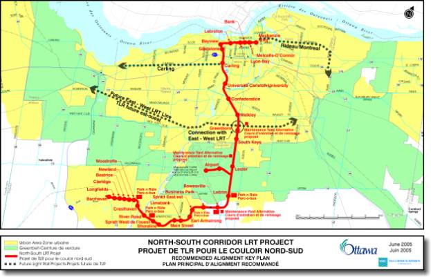
This Environmental Assessment is seeking approval for the full build-out of the recommended plan for the North-South Corridor Light Rail Transit Project to address the transportation demand in the corridor to 2021. This plan identifies the construction of an electrified, double-track Light Rail Transit system on an exclusive right-of-way from the Barrhaven Town Centre in southwest Ottawa, north and east to the Rideau Centre in downtown Ottawa. It covers 29 km plus a 2 km spur line to the Ottawa Macdonald-Cartier International Airport. It includes 34 stations – 27 new and 5 existing on the main line and 2 along the Airport spur. The plan identifies 5 Park & Ride lots. Trains will operate at approximately 3-minute headways to serve the expected 60,000 to 70,000 daily riders in 2021. The recommended plan described herein is illustrated on the attached plates in Exhibit 1 – Alignment Plan and Profile Drawings. An overview plan of the project is shown in Figure 1.
Description of Plan
The southern terminus of the Light Rail Transit facility is at Barrhaven Town Centre, southeast of the Strandherd Drive/Greenbank Road intersection, where there will be a future interchange station with the proposed extension of the Southwest Transitway. From here, the line runs easterly at grade, within the median of the future Chapman Mills Drive through South Nepean, crossing Woodroffe Avenue at grade to reach Woodroffe Station. There are 4 proposed stations within this stretch of the Light Rail Transit line, situated at the intersections of the future Longfields, Claridge, Beatrice and Newland streets. The first Park & Ride lot is located at Woodroffe Station with accommodation for approximately 825 vehicles in the northeast quadrant of the Woodroffe Avenue and Strandherd Drive intersection.
East of Woodroffe Station, the line curves around to the north of the Nepean woods within an exclusive right of way, then swings south crossing under Cresthaven Drive where a station is located. As the line extends east from Cresthaven Station, it rises above ground to cross over Prince of Wales Drive immediately south of the Strandherd Drive intersection. The Light Rail Transit line crosses the Rideau River on a separate structure adjacent to the proposed new Strandherd-Armstrong train/car bridge, passing under River Road immediately south of the Armstrong Road intersection on the east side of the river. Initially, the Light Rail Transit line will cross the river using two lanes of the eventual 6-lane Strandherd-Armstrong bridge.
East of River Road, the line rises out of the ground to meet at grade at River Road Station, where a 1,000 vehicle Park & Ride lot is located. From there, the line runs at-grade, swinging south through West Spratt and Shoreline Stations to bypass the Astral Media communication towers and Armstrong South Woods. From there, the tracks head easterly within the median of a mainstreet-type development – similar to Chapman Mills Drive in South Nepean – and continues east through the Riverside South community core to Main Station. East from Main Station an at-grade crossing takes the line across Limebank Road to Limebank Station, then extends east and north within an exclusive right of way to cross over Mosquito Creek. The line then crosses Earl Armstrong Road at grade, with a station located at the crossing. Through this EA, a suitable property envelope to allow Earl Armstrong to go either over or under as it crosses the Light Rail Transit line will be protected.
The line extends northeast of Earl Armstrong to Spratt East Station, then turns due east, heading to Business Park Station – the eastern-most station within the Riverside South community. On the east periphery of Riverside South lies Bowesville Station, which will exist solely to serve a Park & Ride lot accommodating up to 3,000 vehicles. The Light Rail Transit line continues easterly, still within an exclusive right-of-way, until it intersects with the abandoned north-south Canadian Pacific Railway (CPR) – Ellwood Subdivision.
From this point, the Light Rail Transit line turns northerly and operates exclusively within the former CPR right-of-way all the way to Bayview Station. The first station along this portion of the corridor is approximately 350 m south of Leitrim Road, with accompanying 1,200 spot and 2,500 spot Park & Ride lots being located on both the east and west sides of the line respectively. The line then crosses Leitrim and Lester Roads at grade, with Lester Station located at the intersection to provide a location for passengers to transfer from the regular Light Rail Transit line to a Light Rail Transit or other transit service that will be serving the Airport. Lester Road will be widened to 4 lanes at the rail crossing.
Between Leitrim and Lester Roads, a 2.2 km Airport link heads westerly to serve stations at a future development site near Alert Road and at the Airport terminal. The twin-track link operates in an exclusive right-of-way and crosses under the Alert Road intersection and the Delta Taxiway.
From Lester Road, the line continues north to a new Light Rail Transit station adjacent to the South Keys Transitway station, then to the existing O-Train Greenboro Station. This station is located south of the existing east-west freight railway tracks (CN Walkley Subdivision) and a potential future east-west Light Rail Transit line. A parallel dedicated third track running south from the freight line is required to provide freight access to the NRC testing facility adjacent to the Airport.
A new structure will be built to carry the Light Rail Transit line over the existing east-west freight line to provide safe and reliable high-frequency Light Rail Transit service. From this grade separation, the existing track will be utilized and a new track will be constructed adjacent to it. The next station encountered is at Walkley Road.
Along this stretch, the Light Rail Transit line is located on the east side of the Southeast Transitway, turning easterly to pass under the railway south of Heron Road. It is at this location that another grade separation is required to permit the Light Rail Transit tracks to pass over the existing VIA Rail passenger railway tracks, as well as Sawmill Creek and the Southeast Transitway.
The Light Rail Transit line continues north of the grade separation to a reconstructed Confederation Station located immediately south of Heron Road. The Light Rail line then continues northerly towards Carleton University. Widening of the existing single-track bridge over the Rideau River, immediately south of the Carleton University campus, is required to accommodate twin tracks. Just north of the river, a new Carleton Station will be situated to tie into future university development plans.
The existing O-Train passes under Dow’s Lake in a single-box railway tunnel. For the double-track Light Rail Transit line, a second single-track tunnel will be constructed parallel to the present tunnel. Minor work will be carried out to embankments and retaining walls under the Beech Street, Young Street Pedestrian Crossing, Gladstone Avenue and Somerset Street structures to accommodate the double tracking. The existing station at Carling will be modified to accommodate the twin-track Light Rail Transit line, and new stations will be located just south of Gladstone Avenue and Somerset Street.
The tracks continue north to Bayview Station, located just south of the existing Scott Street bridge providing direct pedestrian access to integrate all surrounding development areas. The tracks then turn easterly, running on either side of the Transitway within a new right-of-way through LeBreton Flats. LeBreton Station will be a combined Light Rail Transit and bus facility located at Booth Street. The corridor crosses under Booth Street to provide integration between the Light Rail Transit, Transitway and bus services serving Gatineau across the Chaudière Bridge.
From LeBreton Flats, the tracks rise up the escarpment on a 5% grade and connect to the west end of Albert and Slater Streets. A crossover track will be located in this area to allow operation flexibility. Both Light Rail Transit and bus rapid transit service will operate in the second lane out from the curb on the right hand side each of Slater (eastbound) and Albert (westbound) Streets. With the tracks running in a straight line, the Light Rail Transit platforms extend from the curb for passenger boarding, whereas the buses move into the curb to pick up passengers and allow Light Rail vehicles to pass. Three Light Rail Transit platforms are located on each of Albert and Slater Streets between Bay Street and Elgin Street, alternating with bus stations on every second block. All existing accesses will be maintained as well as almost all (92%) of parking, loading and taxi access.
The tracks then converge on the western approach to the Mackenzie King Bridge where the line terminates at the Rideau Centre at Mackenzie King Station. A crossover track will be located at the western approach to Mackenzie King station, and tail track will extend beyond the station platform for operational reasons.
Needs and Alternatives
The first tasks in carrying out an EA are determining the need and justification for the project, identifying and analysing alternative solutions to address the need, and identifying a recommended alternative. This task is documented in the attached “Problems and Opportunities and Alternative Solutions Analysis” report (see Document 1).
In considering the project need, a Study Area was established. Centred on the existing O-Train (CP Ellwood) corridor, the study area stretches from downtown (Rideau Centre) to the future Barrhaven Town Centre. Bounded by the Ottawa River Parkway and the existing aqueduct to the north and Wellington and Albert Streets to the south, the study area extends easterly from the O-Train corridor through LeBreton Flats. Within the downtown, the study area boundaries are Wellington and Rideau Streets to the north, Laurier Avenue to the south and King Edward Avenue in the East. The study area also includes an Airport link, while the southern and western extension through Riverside South and South Nepean generally conformed to alignments identified in related community planning studies.
The principal need for this project is to address the current and future travel demand between growing communities in south Ottawa and downtown, as well as points in between that will create demand through projected population and employment growth. Five alternatives were identified for assessment in terms of their ability to address this need:
· Do Nothing;
· Expand Arterial Roadway Network;
· Expand Rapid Transit Services Outside the Corridor;
· Expand Rapid Transit Services Within the Corridor; and,
· Combination of Expansion of Rapid Transit and Arterial Road Networks.
These five alternatives were evaluated based on four categories: Transportation System; Natural Environment; Policy and Planning; and Socio-Economic Environment. Within each category, criteria were developed that reflected the need and provided meaningful comparisons of the alternatives. The alternatives were analysed and a relative comparison approach was used.
In summary, the evaluation identified that:
· A Do Nothing alternative does not support the significant growth in travel demand anticipated in the study area and would result in severe roadway congestion and congestion-related pollution.
· The Expand Arterial Roadway Network alternative would require 14 additional roadway lanes to address the need, which cannot be physically accommodated without significant negative social and environmental impacts.
· Expanding Rapid Transit Facilities Outside the Corridor does not address the transportation problem within the Study Corridor, and does not provide the level of service and connections required to serve the growing communities in the Corridor.
· Expanding Rapid Transit Facilities Within the Corridor does not fully address the travel demand and development needs in the Corridor. While providing strong environmental benefits through reduced motor vehicle use, it also results in significant residual congestion on the roadways in the south end of the city.
· The Combination of Expansion of Rapid Transit and Arterial Road Network in the south end of the City provides for a balanced transportation system that fully meets forecasted travel demands in the Study Corridor.
The evaluation identified that a transit-only option will accommodate a large proportion of the transportation demand but not provide for full mobility, since transit alone cannot serve all trips or all destinations. Therefore the recommended solution is a combination of expansion of rapid transit service combined with limited additions to the arterial road system in the south end of the City. The North-South Corridor Light Rail Transit Project is the rapid transit component of this alternative. This recommendation is in compliance with Council’s approved Transportation Master Plan and Official Plan.
Ridership
Forecasts
A ridership forecast study was undertaken as supporting documentation for the EA. The Ridership Study used three different approaches to forecasting (for comparative purposes): Direct Demand; Market Analysis; and TRANS Modelling, which is the most comprehensive.
Table 1 summarizes the forecasted ridership by year and for various staging options.
Table 1: Summary of North-South Corridor Light Rail
Transit Project Forecasts
|
Year |
Scenario / Staging Option |
AM Peak Period Headway (min) |
Airport Link? |
AM Peak Hour Riders |
Peak Load (pphpd) |
AM Peak Hour Additional Riders2 |
Daily Riders |
|
2003 |
Existing Conditions1 |
15 |
No |
680 |
N/a |
N/a |
7,500 |
|
2011 |
Base Case |
15 |
No |
770 |
480 |
90 |
7,900 |
|
Build – Rideau Centre to Limebank |
5 |
Yes |
4,360 |
1,690 |
3,680 |
36,700 |
|
|
Staging Option – Rideau Centre to Woodroffe |
5/7.5 |
Yes |
4,890 |
1,790 |
4,210 |
40,700 |
|
|
Build – Rideau Centre to Barrhaven Town Centre |
5 |
Yes |
5,280 |
1,740 |
4,600 |
43,500 |
|
|
2016 |
Build – Rideau Centre to Limebank |
5 |
Yes |
5,120 |
2,010 |
4,440 |
43,100 |
|
Staging Option – Rideau Centre to Woodroffe |
5/7.5 |
Yes |
6,000 |
2,200 |
5,320 |
49,200 |
|
|
Build – Rideau Centre to Barrhaven Town Centre |
5 |
Yes |
6,680 |
2,250 |
6,000 |
54,200 |
|
|
2021 |
Base Case |
15 |
No |
870 |
580 |
190 |
8,900 |
|
Build – Rideau Centre to Limebank |
5 |
Yes |
5,980 |
2,230 |
5,300 |
49,600 |
|
|
Staging Option – Rideau Centre to Woodroffe |
5/7.5 |
Yes |
6,980 |
2,440 |
6,300 |
56.200 |
|
|
Build – Rideau Centre to Barrhaven Town Centre |
5 |
Yes |
7,830 |
2,510 |
7,150 |
62,600 |
1 Based on OC Transpo 2003 riding counts
2 New LRT
riders relative to 2003 existing conditions
It should be noted that Airport-related demand associated with a direct link to the Airport is low, estimated at approximately 130 AM peak hour trips (1,800 daily trips) by 2021 – based on a 15-minute headway service.
The Ridership Study also examined the results of sensitivity tests to determine the impact of transit-supportive policies and measures on ridership. Each of the sensitivity tests has a positive impact and represents the higher range in ridership that might be achievable in the future if transit-supportive policies are successfully implemented (Table 2).
Table 2: North-South Corridor Light Rail Transit
Project Ridership – Sensitivity Tests
|
Year |
Scenario/Staging Option |
Sensitivity Test |
AM Peak Hour Riders |
Daily
Riders |
|
2021 |
Rideau Centre to Limebank |
Base |
5,980 |
49,600 |
|
High Light Rail Transit Speed |
6,670 |
55,400 |
||
|
High Auto Cost |
7,840 |
65,100 |
||
|
Low Road Expansion |
6,700 |
55,600 |
||
|
Rideau Centre to Barrhaven Town Centre |
Base |
7,830 |
62,600 |
|
|
High Auto Cost |
9,950 |
79,600 |
||
|
Low Road Expansion |
8,600 |
68,800 |
Base - base case forecast; 5 minute peak period
headway.
High
Light Rail Transit Speed – 5 km/h increase in Light Rail Transit operating
speed.
High
Auto Cost – 50% increase in parking costs and expansion of the pay parking
area.
Low
Road Expansion – no increase in road capacity over existing levels in the
North-South Corridor.
The projected North-South Light Rail Transit ridership compares very favourably to ridership of other Light Rail Transit systems in North America and would fall in the higher end of the ridership range based on the 2021 ridership forecast (Table 3).
Table 3: 2002 Ridership for North American Light Rail
Transit Routes
|
Region |
Route |
Length |
Stations |
Weekday
Ridership |
|
Baltimore (MTA) |
Hunt Valley-Cromwell |
92.7 |
32 |
24,700 |
|
Boston (MBTA) |
D-Riverside |
21.7 |
24 |
21,800 |
|
Buffalo (NFTA) |
Metro Rail |
10.3 |
8 |
25,000 |
|
Calgary (CTS) |
202-Whitehorn |
14.3 |
9 |
60,200 |
|
Cleveland (GCRTA) |
67X-Blue |
49.6 |
35 |
11,800 |
|
Cleveland (GCRTA) |
67AX-Green |
|||
|
Dallas (DART) |
Red |
72 |
34 |
51,200 |
|
Dallas (DART) |
Blue |
|||
|
Denver (RTD) |
D-Green |
22.4 |
20 |
31,400 |
|
Edmonton (ETS) |
Light Rail Transit |
12.3 |
10 |
38,000 |
|
Los Angeles (LACMTA) |
Blue |
34.3 |
22 |
72,300 |
|
Los Angeles (LACMTA) |
Green |
32.0 |
14 |
33,400 |
|
New Orleans (RTA-NO) |
St. Charles |
10.6 |
57 |
11,600 |
|
Newark (NJT) |
City Subway |
9.7 |
12 |
16,900 |
|
Pittsburgh (PAT) |
42S-South Hills |
16.9 |
36 |
19,300 |
|
Portland (TriMet) |
Blue-East/West |
52.1 |
46 |
70,300 |
|
Portland (TriMet) |
Red-Airport |
20.6 |
19 |
10,500 |
|
Sacramento (SRTD) |
Light Rail |
33.1 |
30 |
29,000 |
|
St. Louis (Bi-State) |
MetroLink |
73.5 |
26 |
42,400 |
|
Salt Lake City (UTA) |
701-North/South |
19.8 |
15 |
29,500 |
|
Salt Lake City (UTA) |
702-University |
4.0 |
5 |
|
|
San Diego (SDT) |
Blue |
40.5 |
31 |
50,000 |
|
San Diego (SDT) |
Orange |
34.8 |
24 |
24,500 |
|
San Francisco (SF Muni) |
F-Market & Wharves |
9.7 |
30 |
19,200 |
|
San Francisco (SF Muni) |
J-Church |
25.3 |
N/a |
15,200 |
|
San Francisco (SF Muni) |
K-Ingleside |
21.2 |
N/a |
25,300 |
|
San Francisco (SF Muni) |
L-Taraval |
8.7 |
N/a |
29,900 |
|
San Francisco (SF Muni) |
M-Ocean View |
10.9 |
N/a |
33,300 |
|
San Francisco (SF Muni) |
N-Judah |
21.2 |
N/a |
45,600 |
|
San Jose (VTA) |
Baypointe-Sta. Theresa |
29.0 |
31 |
24,600 |
|
San Jose (VTA) |
Mountain View-Milpitas |
18.5 |
19 |
5,600 |
|
Toronto (TTC) |
501 Queen |
24.5 |
210 |
45,100 |
|
Toronto (TTC) |
504 King |
12.7 |
125 |
50,700 |
|
Toronto (TTC) |
506 Carlton |
14.8 |
154 |
40,300 |
|
Toronto (TTC) |
510 Spadina |
5.6 |
42 |
40,200 |
Source:
Transit Capacity and Quality of Service Manuel – 2nd Edition
Technology Selection (Bus vs. Rail)
An evaluation of bus and rail rapid transit technologies within the project Corridor was carried out to select a preferred and appropriate transit mode. This is presented in the “Overview Assessment of Rail and Bus Technologies” report (see Document 2). This evaluation considered capital and operating cost, air quality, noise and vibration comparisons, as well as other strategic issues such as the capacity to accommodate more buses in the central core and the ability to attract riders and new development within the Corridor.
In order to provide a comparison on an “apples-to-apples” basis, theoretical Light Rail Transit and Bus Rapid Transit systems were developed to serve the north-south Study Corridor from Barrhaven in the southwest to the Rideau Centre in downtown Ottawa. The system scenarios were developed based on the longer-term (2021) scenario.
For purposes of
comparing the theoretical Light Rail Transit and Bus Rapid Transit system costs
and operation, a range of 60,000 to 70,000 passengers per day was used.
Because of the different size and passenger-carrying capacity of typical Light Rail Transit and Bus Rapid Transit vehicles (a typical Light Rail Transit vehicle can carry twice as many passengers as a Bus Rapid Transit vehicle), the time between vehicles (headway) and the number of vehicles required to carry an identical number of passengers in the peak hour will be different. This has an impact on operating costs since fewer vehicles equates to fewer operators required, and lower energy costs, i.e. the overhead costs are lower.
In order to carry the projected number of peak-hour riders in the Study Corridor the required peak-hour headways in minutes for Light Rail Transit and Bus Rapid Transit are shown in Table 5, below:
Table 5 – Peak Hour Headways
|
Vehicle Type |
Headways Based on Daily Ridership |
|
|
|
60,000 riders |
70,000 riders |
|
Light Rail Transit (28 m vehicle) (1 car train) |
2.7 minutes |
2.3 minutes |
|
(2 car train) |
5.4 minutes |
4.6 minutes |
|
Bus Rapid Transit (articulated 18 m vehicle) |
1.4 minutes |
1.2 minutes |
As shown, buses can operate on shorter headways but will require from 2 to 4 times more vehicles and operators to carry the same number of passengers as Light Rail Transit vehicles.
Relative planning-level comparative costs of representative Light Rail Transit and Bus Rapid Transit systems in the same corridor were developed. Cost components included capital costs for the full build-out (2021) system, annual operating costs (including operation and maintenance) and life-cycle vehicle and infrastructure replacement costs over a 50-year period. Fifty years was chosen to take into account the longer life of a typical Light Rail Transit vehicle, which can last between 40 and 50 years (with refurbishment).
The comparisons of Light Rail Transit and Bus Rapid Transit systems are as follows:
(i) Capital Cost
Comparison
Infrastructure capital costs for Light Rail Transit and Bus Rapid Transit systems worldwide range widely depending on the location and nature of the installations. In general, Light Rail Transit installation costs tend to be higher than Bus Rapid Transit costs but the vehicles and systems last longer and have lower life cycle replacement costs.
For this comparative estimate, certain similarities were assumed. For instance, it was assumed that the stations, whether for Light Rail Transit or Bus Rapid Transit, were the same.
On a comparative basis, the infrastructure installation capital costs for the full build-out (2021) Light Rail Transit system was estimated at approximately 18% more than an equivalent Bus Rapid Transit system in this Corridor. Light Rail Transit vehicles are also more expensive, but fewer Light Rail Transit vehicles are required compared to buses and they have a useful lifespan up to 3 times longer than Bus Rapid Transit vehicles. Vehicle costs raised the total initial capital cost differential (for the 2021 system) to approximately 28% more for Light Rail systems than bus systems.
(ii) Annual Operating Cost Comparison
In order to calculate the per-hour operating costs for both Light Rail Transit and Bus Rapid Transit, it was important to develop a scenario with which one could determine the annual operating hours for either a Light Rail Transit or Bus Rapid Transit system, depending on the actual forecast ridership. A simple spreadsheet model was developed and with an input of 60,000 riders per day, the annual operating hours, and the mode-related headways, the number of peak and off-peak vehicles for each mode can be determined.
In comparing annual operating experience for Light Rail Transit and Bus Rapid Transit, actual Ottawa operating costs were used for the Bus Rapid Transit hourly cost assumptions. For Light Rail Transit operating costs, information from the US Federal Transit administration database on the Pittsburgh and Denver systems was used. A comparative check of the Calgary Light Rail Transit operating costs was also carried out.
Using these numbers, the annual Light Rail Transit operating costs are approximately 83% of the cost of operating an equivalent Bus Rapid Transit system, mainly because the larger Light Rail Transit vehicles require fewer operators over a given time period.
(iii) Life Cycle
Replacement Cost Comparison
The costs of major capital vehicle and infrastructure replacement and refurbishing have been compared over a 50-year period. Light Rail Transit vehicles will last 40 to 50 years, assuming a major rebuild at 25 years, while buses would be replaced every 15 years (on average). Based on these assumptions, the life cycle replacement costs for the Light Rail Transit system are 27% of the costs for the comparable Bus Rapid Transit system.
(iv) Total Long-Term
Cost Comparison
In terms of total costs when all three cost elements above are considered, construction costs are higher for Light Rail Transit than Bus Rapid Transit. However, over time, the Light Rail Transit savings in operating cost and life-cycle replacement cost more than compensates for the initial start-up costs. For the two comparative systems described in this analysis, the break-even point is approximately 20 years.
(v) Air Quality
In comparing the impact on air quality, the primary concern is in the Corridor itself and more importantly in the downtown core, where there is a higher concentration of vehicles. Electric Light Rail Transit will not produce any atmospheric emissions in the transportation Corridor - however, it may produce emissions at source of power production. On the other hand, buses will produce atmospheric emissions within the Corridor, regardless of whether they use diesel or hybrid technology for motive power.
(vi) Noise
The pass-by noise levels for rail and bus transit technologies are very similar, with electric Light Rail Transit being slightly quieter. With respect to acceleration/deceleration, there is a noticeable difference between Bus Rapid Transit and Light Rail Transit vehicles. For diesel engines, this increase in ambient noise is quite intrusive whereas electric Light Rail Transit vehicles have no noticeable start-up/acceleration sound increase.
(vii) Vibration
Vibration levels for the lighter Bus Rapid Transit vehicles will be less than those of the heavier Light Rail Transit vehicles. While vibration from Light Rail Transit vehicles is higher than that of buses (except where buses cross a structural expansion joint, drainage catch basin or utility access cover and create a vibration from the impact), the typical Light Rail Transit vibration is not intrusive and can be mitigated where sensitive receptors are an issue.
(viii) Capability of
Accommodating More Buses in the Downtown
Because of the success of the bus systems in Ottawa and Gatineau, the ability of downtown Ottawa to accept more buses, both physically and environmentally, has reached a saturation point.
There are currently two primary east-west transit corridors in central Ottawa:
1. The Albert and Slater Street Transitway connects to the Mackenzie King Bridge across the Rideau Canal. This corridor is currently served by approximately 170 buses per peak hour per direction and is generally considered to be at capacity, with existing operational problems during the peak period. All of the core Transitway services (routes 95, 96 and 97) use the corridor along with all downtown peak-period-only routes serving residential areas throughout the urban area.
2. The Rideau Street (east of the Rideau Canal) and Wellington Street (west of the Canal) corridor carries transit service from two transit agencies. OC Transpo’s downtown service that doesn’t use the Transitway uses this corridor east of Bank Street. These routes serve many of the older urban areas that have been served by similar routes for at least the past 35 years. All of the STO’s routes entering downtown Ottawa use the corridor between the Portage Bridge and King Edward Avenue. Bus volumes during the peak periods range from 70 to 140 buses, depending on the direction and the time period.
As the City’s population and employment increases, ridership and the number of buses required for service on the existing Transitways will continue to grow. This growth in buses can be accommodated on outlying portions of each Transitway, but not where they converge in the downtown. Alternative operating plans are presently being developed by Transit Services to address this issue and to minimize the number of buses in the downtown. A report on how the City will achieve bus reductions through the downtown core is scheduled for completion later this year.
In addition to the physical and operational capacity issues related to the present bus service in the downtown, it has also been made clear through the public consultation process that there is a desire for fewer buses in the downtown because of environmental and social issues - including exhaust fumes, diesel noise, and the image of Ottawa as the a G8 capital city and international tourism destination. Additional bus service from a new north-south transit corridor into the downtown is not an acceptable option and would only exacerbate an existing problem.
(ix) Ability of Light
Rail Transit to Attract Riders and Development
There is a very strong belief worldwide that Light Rail Transit is a more attractive transit service than buses that will attract more non-transit riders, and that if properly integrated with development, it will also encourage more transit-related development in a given corridor. Part of this attraction is the perceived “permanence” of the corridor and part is the smoother ride quality of Light Rail Transit systems. Buses have a generally poorer image because of the stereotype of diesel fumes and crowded and uncomfortable box-like vehicles. Some of the newer more modern bus designs are attempting to overcome this image by imitating the appearance of Light Rail Transit vehicles.
In spite of the improvements in Bus Rapid Transit vehicles, the public perceives that most riders would choose a Light Rail Transit vehicle over a bus if given a choice.
Summary
Conclusions
When considering all of the factors related to rapid transit service in the North-South transportation corridor, rail (Light Rail Transit) is preferred because:
1. Given the projected ridership, Light Rail Transit service could be operated with lower overhead costs.
2. The existing Transitway through the downtown is at capacity and cannot accommodate any additional buses.
3. Light Rail Transit will not add to the atmospheric emissions in the corridor, whereas even “cleaner” diesel or hybrid buses will increase the level of contaminants, especially in the already congested downtown area.
4. A large section of the North-South Corridor is already an existing rail corridor.
5. Light Rail Transit has the potential to attract more riders and more significant development adjacent to the Corridor, especially in the Bayview, LeBreton Flats and Riverside South areas.
6. While Light Rail Transit is initially more expensive to implement, there are savings in operating and life cycle replacement costs over time.
Electric versus Diesel Power
The diesel self-propelled Talent trains (DMUs) presently providing the existing O-Train Pilot Project services have proven to be excellent and attractive rail vehicles for the start-up demonstration service. Many of these types of vehicles operate successfully on commuter lines in Europe.
While DMUs can be excellent longer-distance commuter rail vehicles, in the context of Ottawa’s North-South Light Rail Transit line they must be able to operate in the downtown on City streets. DMUs are generally longer, wider and heavier than a typical electric Light Rail Transit vehicle and cannot negotiate tight curves, making them more difficult to navigate within normal downtown traffic lanes. Because they are propelled by diesel rather than electric motors, their peak power and ability to climb steeper grades is limited. Their diesel engines also contribute undesirable exhaust emissions (although better than a diesel bus) and require more maintenance and more frequent replacement than a typical Light Rail Transit electric motor.
Because of the above factors, electric Light Rail Transit is the preferred rail mode for consideration for the long term application on the North-South Light Rail Transit line operating through the Barrhaven and Riverside South urban centres and into Ottawa’s downtown.
Alignment Considerations
Since the north-south portion of the preferred plan alignment lies within an existing rail corridor, the sections requiring further study were the segments extending south and west through Barrhaven Town Centre and Riverside South; easterly from Bayview Station through LeBreton Flats across the downtown to the Rideau Centre; and to the Airport. A brief discussion on the development of each of these alignment segments follows.
Barrhaven Town Centre/South Nepean
The South Nepean Town Centre Urban Design Plan (UDP) study provided input towards determining the location of the Light Rail Transit Corridor within the future Barrhaven Town Centre. As the UDP study is still underway, the final location of the Light Rail Transit alignment may be refined as the design plan is finalized. Accordingly, the North-South Corridor Light Rail Transit Project EA Report (EAR) will be written to ensure the City’s interests are protected by setting out the necessary property envelope for the facility, yet providing the flexibility to allow for appropriate future adjustments to the alignment brought about and confirmed through approval of the UDP.
The ultimate southern terminus of the North-South Corridor Light Rail Transit project lies within the future Barrhaven Town Centre at the convergence point with the proposed future extension of the Southwest Transitway. This intersection point is identified as a “Transit Centre” within the UDP, and therefore a highly desirable location for higher-density forms of development that support the City’s Official Plan objectives for transit-centred development. The Southwest Transitway Extension (Strandherd to Cambrian) EA was initiated by the City in the fall of 2004, with the Terms of Reference approved by the Ontario Minister of the Environment in June 2005. That EA will evaluate and develop options for a multi-modal transit station at the intersection of the future bus Transitway and the N-S Light Rail Transit line.
Through Barrhaven Town Centre and extending easterly through South Nepean to Woodroffe Avenue, the Light Rail Transit line is situated within the centre median of Chapman Mills Drive (formerly South Nepean Main Street), separated from traffic by planted medians. Chapman Mills Drive has a long planning history as a key east-west route through South Nepean, and as a spine for higher-order rapid transit. Its alignment through the Town Centre is based on a desire to create development frontage on both sides as an edge to mixed-use development and a transition to the residential areas in the Town Centre. The configuration of the Light Rail Transit line, situated in the median within a 41 m right-of-way, was developed through close cooperation between the land owner (Minto) and the former City of Nepean/RMOC and City of Ottawa.
East of Woodroffe Avenue, the radius of curvature as the alignment swings around the northern edge of the Nepean Woods was chosen to minimize the potential impact on the wood lot.
Riverside
South
The preferred alignment for the Light Rail Transit Corridor serving Riverside South was determined as a component of the Riverside South Community Design Plan (CDP) study. In support of the CDP study, a separate functional planning study was undertaken to address how to serve the Riverside South Community with rapid transit. The goal of that planning study was to identify a corridor right-of-way such that land-use planning and development in the area can proceed with long term planning objectives in mind, and with public input through the consultation process for the CDP.
A summary of the findings of the planning study is included in the Southern Corridors and Alignments report (see Document 3) which discusses the options developed to provide rapid transit from South Keys Station, through Riverside South, and ending at the Rideau River. The options considered a number of factors including service to the Airport, service to the community, land-use development and principles, staging, and technology. Corridor options considered are shown in the report. These options were assessed against a set of quantitative and qualitative criteria to identify a preferred Corridor option.
Based on the screening factors and criteria of natural environment, socio-economic, land use, transportation, and costs, a corridor alignment was identified. The alignment runs along the existing railway corridor, turning west south of Leitrim Road, into and through the Town Centre located in the vicinity of the Limebank/Earl Armstrong intersection, then west to cross the Rideau River at the proposed Strandherd-Armstrong bridge. This alignment follows the southern edge of the of the Airport zone of influence and the boundary between the planned business park around Leitrim Road and the planned residential development around Earl Armstrong Road to the south.
Principal factors in selecting this Corridor as the preferred option include:
- Serves largest potential market;
- Little or no impact to existing communities;
- Minimal impact to existing road network;
- Staging simpler than other options; and,
- Least costly option in terms of construction costs.
During the course of this EA study, minor revisions were made to the alignment in coordination with the ongoing Riverside South CDP. These revisions principally included modifications to curve radii to ‘smooth’ the line, and a minor relocation in the bend southwest of the Armstrong South woods to avoid conflict with the Astral Media communications towers and associated ground plane.
Bayview
Station Area
The recommended Light Rail Transit alignment through the Bayview area is centred on the development of a multi-modal transit station, integrating the surrounding land uses with a key interconnection of the bus and rail rapid transit networks. The Official Plan in concert with previous planning work, has identified lands surrounding the Bayview area as a mixed-use centre intended to facilitate a more intense development pattern than presently exists, oriented to the rapid transit network. The implementation of Bayview Station is crucial to its success.
It is recognized that the configuration of Bayview Station will evolve over time as local development proceeds. The layout of the proposed Light Rail Transit tracks is constrained by the presence of the existing Scott Street and Transitway bridges. The actual turning radii for the Light Rail Transit tracks going from a N/S direction to an E/W direction is critical so that excessive land is not consumed and remnant unusable land parcels do not result. Accordingly, the EA-recommended plan defines a sufficient property envelope to allow a range of flexibility in the configuration and design of the Light Rail Transit tracks and station, while maintaining high-quality interconnections between Light Rail Transit and Bus Rapid Transit segments of the transit network.
The proposed property envelope is focused on the location of the Light Rail Transit platform on the north-south line positioned just south of the existing Scott Street bridge. This places the platform at the heart of the surrounding developable lands. A range of possibilities is available for locating the Bus Rapid Transit platforms on the existing Transitway to permit passenger transfers from Light Rail Transit to Bus Rapid Transit and vice-versa. Covered walkway connections would be provided. Walkways and integrated pedestrian links through the adjacent communities will connect to the Light Rail Transit and Bus Rapid Transit platforms.
LeBreton
Flats
The 1997 Land Agreement between the NCC, the former Regional Municipality of Ottawa-Carleton and the old City of Ottawa incorporated a redevelopment plan (Concept Plan) for LeBreton Flats, which included a realignment of the Transitway to midway between the open Aqueduct and Wellington Street. Since then other studies such as the completion of the functional design for the relocated Transitway with potential co-location of the Light Rail Transit Corridor and the Booth Street Grade Separation, and implementation activities including the construction of the Canadian War Museum and the NCC approval of the proposal for the first phase of residential development by Claridge Homes, have moved the Concept Plan forward.
Recently, through the course of this EA, the NCC proposed a change to the alignment of the Light Rail Transit/Transitway in order to accommodate larger development parcels along Wellington Street and to provide opportunities for a high-quality recreational pathway environment along the south side of the open Aqueduct. The Light Rail Transit/Transitway Corridor is now proposed to be located immediately south of the existing Transitway alignment as a result.
This new alignment of the Light Rail Transit/Transitway through LeBreton Flats was presented to NCC’s Advisory Committee on Planning, Design, and Realty (ACPDR) for confirmation in June 2005. Pending EA approval, the land transfer agreement will be modified accordingly to reflect the new alignment.
Escarpment
District
The western approach to the downtown, lying between LeBreton Flats and Bronson Avenue, is known as the escarpment district. Several constraints influenced the alignment of the transit Corridor within the escarpment district, including: maximum allowable grades for Light Rail Transit and buses, maintaining continuity for general vehicular traffic on both Albert & Slater Streets connecting to Scott Street, maximizing the development potential of remnant lands brought about by the reconfiguration of the transit Corridor and Albert and Slater Streets, and protecting an entrance portal area for a future rapid transit tunnel under the downtown core.
The recommended plan continues the Light Rail Transit tracks and bus Transitway lanes easterly form LeBreton Station within the exclusive Corridor at a 5% grade to Bronson Avenue. This alignment cuts off the existing Commissioner Street entrance to the PWGSC Cliff Street parking lot and access to the tailrace. A new connecting road linked to Empress Avenue will be constructed to replace this access. Two new bridges (one eastbound and one westbound) take the Light Rail Transit tracks and bus lanes over this new access road to signalized at-grade intersections at the crossing of Albert Street and Bronson Avenue. The ‘roundabout-like’ configuration of the road and transit intersections at Bronson Avenue has created the opportunity to provide for a ‘gateway’ entrance feature into the downtown.
Both Albert and Slater Streets east of Booth required realignment to match the geometric configuration of the road, Light Rail Transit and Transitway intersections at Bronson Avenue, and to provide sufficient space to accommodate future development. Previously identified exclusive bus lanes (required for transit services from the downtown to Gatineau via the Chaudière Bridge) will be incorporated, as well as shared cycle lanes and widened sidewalks, boulevards and medians.
Downtown
Corridors
This section summarizes the process undertaken to select the preferred Corridor and lane arrangement for the Light Rail Transit service in downtown Ottawa, between the LeBreton Transitway Station and the Rideau Centre Centre. Three steps were completed: review and selection of the preferred Corridor; development of potential alignments within the preferred Corridor; and evaluation and recommendation of the preferred alignment. Each of these is summarized in the following sub-sections.
Potential
Downtown Corridors
Six potential corridors were reviewed for Light Rail Transit service between Bronson and Elgin: Wellington Street, Sparks Street, Queen Street, Albert Street, Slater Street, and Laurier Avenue. Other corridors were suggested such as north of Wellington along the Ottawa River at the base of Parliament Hill or south of Laurier, but were not considered because of a wide variety of cost, construction and environmental reasons as well as the fact that they were not in close proximity to the major downtown destinations.
There were also 3 potential corridors for crossing the Rideau Canal at the east end of the downtown: Rideau Street, Mackenzie King Bridge, and Laurier Street. It became clear in the early analysis that Rideau Street, through the area of the Rideau Centre, was problematic in that it could only accommodate 2 lanes of Light Rail Transit if all general vehicular traffic lanes were removed.
A number of physical principles were assumed in developing and assessing potential Light Rail Transit service on the six potential corridors:
- Light Rail Transit service should be able to physically fit within the corridor (single track one-way or double track two-way operation, acceptable grades, acceptable turning radii);
- A separate travel lane should ideally be provided for the Light Rail Transit service in order to provide the highest possible quality of service for customers;
- Traffic along the length of the street should be maintained where possible;
- Access to adjacent properties should be maintained;
- Vehicle turning movements should be maintained; and,
- Opportunities should be considered for improving the streetscape.
In addition, a number of common issues among all of the potential corridors were considered:
- The ability of the Corridor to serve downtown destinations effectively;
- The appropriate way to cross the escarpment west of Bronson to access LeBreton Flats;
- The appropriate way to cross the Rideau Canal and serve the Rideau Centre Centre;
- Integration with existing or future development; and
- Consideration of future integration with Interprovincial Rapid Transit service.
Due to the largely built environment in the downtown and the relative proximity of the corridors, many potential impacts are similar and do not serve to differentiate the alternatives. The following summarizes the results of the review of the six potential corridors.
Wellington
Street
Not recommended because:
- The street is closed numerous times during the year for various ceremonial, security and other reasons;
- The street is too far north of the primary transit destinations;
- The requirement to continue along Rideau Street would result in elimination of vehicle traffic lanes.
Sparks Street
Not recommended because:
- The Garden of the Provinces would be impacted as Light Rail Transit service would need to travel through the southern section of the Garden in order to access LeBreton Flats;
- There would be little, if any, space left on the pedestrian mall section of the streets for kiosks, fountains and other elements that enhance the streetscape and pedestrian environment;
- Service would be disrupted periodically due to events around the National War Memorial;
- Sharp turns and small curve radii would be necessary to manoeuvre around the War Memorial, creating wheel/track noise and increased maintenance requirements.
Queen Street
Not recommended because:
- It is physically difficult and expensive to get over or through the escarpment at this location west of Bronson;
- The very narrow right-of-way at the west end of the street would have eliminated parking/loading/stopping for vehicles and/or eliminated one direction of vehicular travel;
- Negative impacts to access and parking/loading on both sides of the street (access and loading requirements for abutting properties on the north side of the street are focused on Queen Street because of limited vehicle access to Sparks Street to the north and the desire to minimize accesses and the corresponding impacts on transit operations on Albert Street to the south);
- sharp left and right turns are required to access either Rideau Street or Mackenzie King Bridge in order to cross the Rideau Canal.
Laurier
Avenue
Not recommended because:
- It is on the far southern edge of the primary transit travel destinations;
- It would require significant removal of on-street parking and loading;
- Regular closure of Laurier Bridge for events and festivals would either prevent service from crossing the Rideau Canal or require noisy and maintenance-intensive turning movements to reach Mackenzie King Bridge;
- There would be negative impacts on residential development at the west end of the street;
- Access to LeBreton Flats down the escarpment would be more difficult and expensive at the west end.
Albert & Slater Streets
Albert and Slater Streets were considered as a one-way pair and have similar operating, access and land use characteristics. They are recommended for the following reasons:
- They are central to the primary travel destinations within downtown;
- They are the primary existing transit corridor, with street operations already optimized to benefit transit;
- One-way road operation accommodates introduction of Light Rail Transit while still being able to maintain substantial on-street parking and loading;
- There is direct access onto the Mackenzie King Bridge, allowing easy access to the Rideau Centre and Congress Centre;
- There is easy access onto both streets at the west end from LeBreton Flats.
Potential Alignments on Albert
& Slater Streets
Two general families of alignments were developed for introducing Light Rail Transit service within the Albert/Slater Corridor:
1. Operating two directions of Light Rail Transit service on one of the streets and two directions of Bus Rapid Transit (Bus Rapid Transit) service on the other street.
2. Operating one direction of Bus Rapid Transit and Light Rail Transit on each of the streets.
Both alignment arrangements would terminate on the Mackenzie King Bridge adjacent to the Rideau Centre.
Operating both directions of Light Rail Transit on one of the streets would require both streets to become essentially two-way. On one street, one lane in each direction would be for Light Rail Transit service, one lane in one direction would be for general traffic, and parking/loading would be available only on one side of the street. The same arrangement would occur on the other street to accommodate both directions of Bus Rapid Transit. Analysis of this alignment arrangement indicated that it should not be considered further for the following reasons:
- This option results in the loss of the left curb lane for parking and loading on both streets. In some cases, there are hotel zones that are eliminated due to the sterilization of this lane. If all the lanes shifted to the right then parking and loading would be available on the left curb lane but vehicles would have to cross an oncoming transit lane (not desirable).
- The streets would change from having only one-way operation for many years to two-way, and this could become difficult for general traffic to adapt to because the one lane for general traffic would remain essentially one-way. The result could be less safe because vehicles exiting accesses on the left side of the street may not look for or be aware of Light Rail Transit vehicles coming from the opposite direction to the main traffic.
- Signalling and left-turning traffic arrangements would become more difficult with two-way flow.
A preliminary preference for operating one direction of Light Rail Transit and Bus Rapid Transit on each of the streets was therefore identified, and a plan showing the existing right-side parking/loading lane, Bus Rapid Transit lane, and general traffic lane with a left-side Light Rail Transit lane was developed.
Consultation
on the Downtown Options
While all of the North-South Corridor Light Rail Transit EA Study has been subject to intensive public consultation, additional consultation with downtown businesses, property owners and tenants was carried out in the development of the downtown alternative.
The preliminary preferred downtown plan was initially presented for comments to an invited list representing downtown stakeholders on the morning of 7 March 2005 and a similar public presentation was made in the afternoon of the same day. A number of concerns were expressed at that time. This plan was also presented to the Study’s Consultation Groups and at three Public Open Houses later in March.
After the Open Houses, a major initiative was undertaken to address the concerns in the downtown. Face-to-face meetings were held with each downtown stakeholder who requested a meeting to discuss issues. A door-to-door canvass was undertaken during the week of 11 April 2005. 104 out of 125 businesses in the corridor responded to the canvass. A status update presentation was provided to the Business Owners and Management Association (BOMA) on 7 April 2005. BOMA is also represented on the Study’s Business Consultation Group.
These activities resulted in the identification of a number of specific issues with the preliminary plan, including:
- Loss of parking, delivery, loading zones and taxi areas
- A feeling that cars were “trapped” in one lane between buses on one side and Light Rail Transit on the other
- Not enough traffic capacity remaining
- Too many buses in downtown
- Why not build a tunnel?
- Mackenzie King Bridge closure to traffic
- Difficult for cyclists on Albert/Slater
- Potential construction impacts
Additional alignment alternatives were developed to address these issues. The new preferred plan has transit (both Light Rail Transit and Bus Rapid Transit) on one side of the street and cars on the other. All present building accesses are maintained and over 92% of the existing total length of parking, loading, taxi, hotel drop-off areas will be retained, as well as all existing turning movements.
This plan was presented to the business groups at a follow-up meeting on 17 May 2005, as well as to the Study’s Consultation Groups and final round of Public Open Houses in early June 2005. The revised plan was generally well received, however there remains a group of approximately 20 businesses who still have concerns about traffic volumes. These concerns are being addressed through the EA’s traffic analysis of the downtown Corridor. This analysis is based on actual peak-hour traffic volume data provided by the City’s Traffic and Parking Operations Branch and has been provided to the concerned group.
The Study team continues to meet with the Albert/Slater group and has provided all available background information to them for review. A presentation was also provided to members of the Albert/Slater group on 2 June 2005 to show the group current traffic impact analyses in the form of the “Vissim” traffic model simulation of the downtown. This model uses industry-standard Vissim traffic modelling software to accurately simulate and visually portray the traffic operation in the downtown, including buses, Light Rail Transit, car and truck traffic, parking, garage access and pedestrian crossings. It includes specific traffic signal timing provided by City staff as well as accurate bus dwell times at stations. The system has been modelled with the current number of 170 buses operating per hour, and a 10% growth component in simulated peak-hour vehicular traffic to examine a worse-case scenario. With this data as inputs, the model shows the street continuing to function efficiently under the normal peak hour conditions. The Vissim simulation compares favourably with actual peak-hour videos from the City’s traffic cameras, providing good assurance that traffic studies have been simulated based on real-life volumes and patterns. It is estimated that when the system opens for operation in 2009, there will be up to 25% fewer buses on the street and Light Rail Transit vehicles arriving every 5 minutes.
Preferred
Downtown Alignment
The recommended plan shown in Exhibit 2 – Albert and Slater Streets Design Plans – has rail and bus and some parking/loading in the two right side lanes with traffic and additional parking/loading in the other two lanes. Light Rail Transit vehicles operate in the second lane out from the curb, and the sidewalk and Light Rail Transit platforms extend out to this lane for the boarding of passengers. Buses operate in the same lane as Light Rail but move into the curb to pick up passengers and allow Light Rail vehicles to pass.
Tunnel Concepts
In the late 1980s, the former Region of Ottawa-Carleton examined grade-separated options for rapid transit services through the central area. One of these options included deep tunnelling. The twin bus tunnels would start from the escarpment near Bronson Avenue in the west, continue under Albert and Slater Streets, and emerge on the east side of the Canal in the vicinity of the University of Ottawa. Four underground stations at Lyon, Bank, Metcalfe and Nicholas were proposed.
Recently, there has been interest expressed by some members of the public that the tunnel option should be re-examined. This is primarily due to concerns with the bus volumes on Albert and Slater. The EA study team has updated the estimated cost of this bus tunnel to be approximately $720 M. This tunnel option would move buses from the streets to a tunnel, with Light Rail Transit on the surface.
If the tunnels were to include both Light Rail Transit and buses, there would be additional costs for tracks, power and signals on top of the $720 M estimate. Albert and Slater Streets would still experience major construction and utility relocations since excavations for stations, elevators and escalators are still needed for these access points at the surface.
Due to the current budget envelope allocated to the North-South Light Rail Transit project, a tunnel option is not being recommended.
Streetscaping
The introduction of the Light Rail Transit system onto Albert and Slater Streets provides the City with a valuable and unique opportunity to rehabilitate and enhance the existing streetside pedestrian environment. The intent is to design the proposed new Light Rail Transit and Albert and Slater Streets as an integrated entity. Both streets will be fully redeveloped over their entire width including the roadway, tracks and all sidewalks up to the building faces. The type of pavement, colour and texture will be selected for durability and for the safety of pedestrians and motorists. Pavement, sidewalks, lighting, plantings and shelters will be designed to enhance the streetscape. Although the ultimate design will be developed during the implementation phase, there are certain urban design elements that should be considered.
Sidewalk surfaces are suggested to comprise bands of unit pavers to provide a smooth-textured walking surface which is different in colour and texture from the roadway and track-bed. A warm stone colour is recommended which enhances the local limestone colour used on buildings in the Capital.
Platform materials should match the adjacent pedestrian surfaces. In the downtown, the platform should be constructed using interlocking stones, called “pavers”, to create a visually expansive sidewalk. In suburban stations, the platforms should be constructed of concrete. Both shall have concrete detailing to highlight level changes along step edges to aid the visually impaired.
Shelters are an important and highly visible opportunity to enhance the streetscape with simple and elegant structures. The canopies are also a key element of the transit line’s brand and identity, and should be selected carefully.
The transit vehicles (buses and Light Rail Transit) operate in mixed traffic but on exclusive lanes. The rail track bed will be flush with the road. It is suggested that the dedicated bus lane and track bed be a visually different material to help motorists be aware of the dedicated lane status, and the material must stand up to Ottawa’s winters. Concrete is suggested for its cost effectiveness and durability.
A key ingredient in a high-quality streetscape is ‘green’ landscape. Currently there are few trees along this Corridor. Trees must be given the best chance of reaching maturity in extreme winter conditions on these urban streets. Where there are existing trees located in the sidewalk, they should be retained in place and new trees can be in filled between them. Generally, trees should be aligned and spaced or grouped appropriate to that block. Existing trees in planters should be removed where they obstruct pedestrian flow. Trees should be planted on Light Rail Transit platforms to offer shade to transit riders. The location of underground utilities will influence the planting locations.
Traffic
Concerns
A traffic simulation model (Vissim) of Ottawa’s downtown core was developed to evaluate the impact of introducing Light Rail Transit operations on Albert and Slater Streets. The traffic analysis considered the cumulative impacts of pedestrians, all cross-street impacts, turning movements, private and commercial vehicle activity, and both transit bus and Light Rail Transit services across each of the signalized intersections within the Albert/ Slater Street corridors.
The operation of the Albert/ Slater Corridor was analysed and evaluated under the most congested period of the day, the afternoon peak hour, when high volumes of traffic are coincident with large pedestrian volumes, vehicle movements from private accesses (mostly parking lots and garages), as well as the through-operation of frequent Light Rail Transit service (every 3 minutes) and between 140 and 170 buses per hour picking up passengers within the Corridor. While general roadway capacity improvements in Ottawa’s central area are not anticipated within the planning period, the analysis also considered an approximate 10% growth in peak hour general traffic throughout the Albert/Slater Street Corridor.
The findings of the traffic simulations were that a single through general traffic lane on Albert/Slater Streets and provisions for separate turn lanes at intersections were sufficient in accommodating the peak hour traffic throughout the planning period. Also with the introduction of Light Rail Transit services, Mackenzie King Bridge would no longer be available as a general traffic crossing of the Rideau Canal, however the resulting traffic diversion (500 vehicles per hour in the peak direction) could be accommodated on adjacent roadways, Laurier Avenue and Rideau Street, while maintaining a ratio of volume to capacity (v/c) of less than 1.0, conforming to the TMP policy for central-area intersections.
The preferred alternative’s use of separate Light Rail Transit platforms along alternating blocks through the downtown ensures that Bus Rapid Transit services will continue to operate without increases in the service time required to load passengers at platforms. This is significant to minimize bus queues, as both the number of buses per hour and the associated wide variance in bus service time at the Transitway platforms adversely impacts the travel times through downtown and the resulting bus-related congestion in the corridor.
The eventual introduction of Light Rail Transit service at three-minute frequencies is therefore not anticipated to impact adversely on either the current Bus Rapid Transit service or the general movement of traffic through the Albert/Slater Corridor within the planning period (2021).
Cyclists
The Official Plan identifies Albert and Slater Streets as part of the on-road cycle network through downtown. Exclusive cycle lanes are not present on these streets, so cyclists travel in mixed flow with general traffic. The addition of Light Rail Transit service on Albert and Slater Streets will not change the nature of the current cycle network, with cyclists continuing to be accommodated in mixed traffic along this section of the Corridor.
The cycle network extends easterly to Sandy Hill and the University of Ottawa, crossing the Rideau Canal on the Mackenzie King Bridge, where median cycle lanes accommodate bicycle traffic. An estimated 500 cyclist per day traverse the Mackenzie King segment of the network. The addition of Light Rail Transit tracks on the Mackenzie King Bridge will require the removal of all vehicular traffic from the bridge other than Bus Rapid Transit. While a conversion of the bridge to transit-only use does not necessarily conflict with the median bicycle lanes, the proposed median Light Rail Transit platform at Mackenzie Station means the cross-town cycling route is no longer continuous through the Mackenzie King Bridge, terminating instead at crosswalks at the east and west ends of the station platforms.
The EA has identified alternatives to mitigate this issue:
- Cyclists may dismount their bicycle at Mackenzie Station and walk their bicycle along the platform to the second crosswalk;
- Use the cycle lanes on the recently reconstructed Laurier Avenue Bridge, and then reconnect to the cycle network at Cumberland;
- Cross the Canal on the soon-to-be-constructed Rideau Canal Pedestrian Bridge at Somerset Avenue. As the City is currently undertaking a review of its cycle network, consideration should be given to identifying additional cross-town routes on other streets that link directly to this Canal crossing.
The City will continue to work with the cycling community to ensure that Light Rail and cycling complement each other to promote environmentally friendly modes of travel. All of the City’s Light Rail vehicles are expected to carry bicycles inside the vehicle, along with their riders.
Stations and
Park & Rides
A detailed description and proposed layout of each station is presented in the attached “Stations Location Report” (see Document 4). Each station is discussed separately and includes descriptions of the current site situation, the purpose of the station, the importance of the station, the planned site situation, and the distances from the station to both the previous and next stations. Exhibits are included to illustrate general location and site information. Station names have been assigned to represent current or planned places and street names, but should not be assumed to be the final station name.
Potential station locations were identified in a variety of ways. Within Barrhaven and Riverside South, station locations were identified as part of the development of community plans. Other locations were identified in previous studies. It is assumed that all stations could potentially be constructed, however their timing will depend on a combination of project phasing and local development requirements.
It is important to note that the locations of several of the stations described and shown therein are not precise because development of related and other infrastructure in the area has not yet begun. Ultimate station locations may be slightly different than shown in order to accommodate final development plans. Sufficient flexibility is built into the recommended plan to allow for refinement of the location and future design of all stations.
The EA examined seven potential locations for Park & Ride lots within the study corridor to be added to the existing lot at Greenboro Station. A summary of the analysis and detailed description and proposed layout of each lot is contained in the attached Park & Ride Sites report (see Document 5). The recommended plan identifies 4 new lots accommodating in total over 7,000 parking stalls identified in Table 6, below:
Table 6 – Park and Ride Lots
|
Station |
# of Spots |
Access From |
|
Woodroffe |
825 |
Strandherd at the intersection of Crestway Dr. |
|
River Road |
1000 |
Earl Armstrong Rd. and new collector road |
|
Bowesville |
3000 |
Bowesville Rd. and Earl Armstrong Rd. |
|
Leitrim (East Side) (West Side) |
1200 1500-2000 |
Leitrim Road in both cases |
The lot at Woodroffe Station would provide access to Light Rail Transit service for South Nepean residents as well as residents in Manotick, Kars, North Gower, Kemptville, and surrounding areas. The lot will have easy access via the two arterial roadways, provide a major customer drop-off ability, allow for connection with bus services using the arterial roads, and accommodate facilities for bus operators.
The lot at River Road Station intercepts commuters travelling from the south on River Road, and serves the western portion of the Riverside South community. The site is located east of River Road, and can be accessed from the first north-south collector road to the east of River Road, and directly from Earl Armstrong Road, at a future signalized access to the commercial property on the northeast corner of the River Road/Earl Armstrong intersection.
The lot at Bowesville Station is required in the longer term, at such point in time when both the Leitrim and/or River Road lots reach their capacity. It will serve the eastern portion of the Riverside South community as well as rural areas to the south. In addition, the facility will be close to the Rideau Carleton Raceway Slots and the possible future site of the Central Canada Exhibition, and could serve as a staging location for shuttle services between the Light Rail Transit service and these activity centres.
The Park & Ride lot at Leitrim Road will be constructed in two phases as demand warrants. The first phase will be located on private property at the end of Quinn Road east of the rail line, accommodating approximately 1,200 vehicles. Expansion potential for as many as 1,500 to 2,000 vehicles is possible on Transport Canada property west of the rail line. The lot will provide access for residents in the Leitrim and Riverside South communities as well as the large rural commutershed in the southeast area of Ottawa and the counties beyond. The east site is preferred over the west site for initial construction because it is closer to the Leitrim development and to Bank Street South, where most of the rural commuters that would use the facility will be coming from. With most traffic to the site coming from the east or southeast, the east site also has the advantage of avoiding a substantial increase in the amount of traffic at the Light Rail Transit/Leitrim Road crossing. The facility will provide access for passenger drop-off as well as stops for feeder bus routes serving the Leitrim development.
Airport Link
In the early 2000s, the Ottawa MacDonald Cartier International Airport (OMCIA), initiated a major redevelopment program. In 2003, the second phase of the plan was completed with the opening of the new terminal and parking garage. The OMCIA has recently begun the planning for expansion to the terminal.
Throughout the redevelopment process, the OMCIA has acknowledged the value of good transit service and is including a provision in its plans for extension of Light Rail Transit to the Airport.
The Airport link alignment was developed as a sub-component of the previously mentioned functional planning study undertaken to address how to serve the Riverside South Community with rapid transit. A range of alignment choices serving Leitrim, Riverside South and the Airport were evaluated. Included were route concepts that connected the Airport in-line with service to Riverside South, and points beyond. The location of the Airport terminal with respect to the Leitrim and Riverside South developments –which the N-S Corridor project is principally aimed at serving – complicated efforts to develop an in-line station at the Airport. Focusing on capturing the higher ridership potential generated by the southern growth communities, the Servicing Study recommended that the main Light Rail alignment bypass the Airport to provide direct, rapid transit service to Leitrim and Riverside South. The Study recommended that the Airport be served by a spur connection extending off of the main line.
The alignment to the OMCIA consists of approximately 2.2 km of twin track with two stations and bridges under the Delta Taxiway and Alert Road. One station is located to allow for integration into the future terminal expansion, the other is situated near Alert Road to integrate with proposed future hotel development. There will be flexibility written into the final EA report to allow refinement to the location and layout of each station as the plans for the terminal and hotel are further developed.
NRC-CSTT
Access Siding
The National Research Council – Centre for Surface Transportation Technology (NRC-CSTT) provides world class surface transportation development and testing services for the rail and road transport industries, defence departments and a wide range of private and public-sector vehicle and equipment manufacturers. Situated on a 51-acre campus southeast of the Airport on Lester Road, the facility houses some of the most sophisticated and useful vehicle R & D and test facilities in the world. NRC-CSTT is a non-subsidized self-supporting business unit within the National Research Council.
A large number of client vehicles are delivered to NRC-CSTT for testing by rail transport, with access provided by the Ottawa Central Railway (OCR) through an agreement with CP Rail on a 4.1 km siding track extending south of the Walkley Yards within the CP Ellwood corridor. A portion of this track is currently used by the O-Train. Prior to its purchase by the City, CP Rail maintained this rail siding specifically for NRC-CSTT access. NRC-CSTT also uses this siding to access sections of the OCR track between Pembroke and Montreal to conduct certain types of vehicle testing.
Historically, up to 20 access moves per year have been required, including both freight and Light Rail Transit type rail vehicles. Vehicle moves currently operate between 9 a.m. and 4 p.m. with the occasional move occurring between midnight and 5 a.m. After-hour moves are required for the movement of specialty and oversize vehicles. A Track Occupancy Permit, which requires 48-hour prior notice, must be obtained by the OCR from Capital Railway to provide the vehicle access move.
Rail access is critical to the business of the NRC-CSTT. The City will ensure the facility has access, however the conversion of the current line to electric Light Rail Transit would preclude vehicle access moves to the NRC-CSTT on the Light Rail Transit line due to conflicts with the overhead power lines and narrow station platform clearance.
To mitigate this problem, it is recommended that the existing siding track be relocated to the west of the twin-track Light Rail Transit line. The existing rail corridor is sufficiently wide to accommodate this third track, and it would continue to cross Hunt Club road on the existing rail overpass structure. The City would retain ownership of this siding and enter into agreements with the OCR and NRC-CSTT to grant access rights.
Structures
The proposed Ottawa North-South corridor Light Rail Transit Program requires construction of a number of new structures and upgrading or widening of a number of existing structures as presented in Table 7 as follows:
Table 7 – Summary of Structural Requirements
|
Structure Location |
Need |
Length |
Remarks |
|
Cresthaven Road |
Carry Cresthaven over Light Rail Transit tracks |
11 m Clear Span |
New Underpass |
|
Prince of Wales Drive |
Carry Light Rail Transit tracks over road |
30m Single Span |
New bridge crossing |
|
Rideau River Crossing (Final Alignment) |
Carry Light Rail Transit tracks over Rideau River |
3 span continuous structure with spans of 43/70/43m |
New bridge crossing |
|
Strandherd/Armstrong Crossing (Interim Alignment) |
To carry Light Rail Transit tracks over Rideau River |
3 span structure with spans of 43/70/43m |
2 lanes of new 6-lane roadway crossing utilized to carry Light Rail Transit tracks over river |
|
River Road Underpass |
Carry River road over Light Rail Transit tracks |
11 m Clear Span |
New Underpass |
|
Mosquito Creek |
Carry Light Rail Transit tracks over creek |
4 span continuous structure with spans of 17/22.5/22.5/17m |
New bridge crossing |
|
Hunt Club Road |
Carry Light Rail Transit tracks over Hunt Club road |
4 span continuous structure with spans of 13/18/18/13 m |
New bridge crossing |
|
Walkley Diamond Grade Separation |
Carry Light Rail Transit tracks over Transitway & OCR freight tracks |
2 single span ( 25m & 15m ) structures and associated 300m lengths of retaining walls |
New Light Rail Transit tracks over Rail Grade separation and associated structural works |
|
Walkley Road Underpass |
Carry Walkley road over Light Rail Transit tracks |
7 m Clear Span Structure. |
A new Underpass to be built beside existing to accommodate 2 tracks |
|
Sawmill Creek |
Carry Light Rail Transit tracks over creek |
A single 28m span structure. |
A new structure as part of the Ellwood Diamond grade separation works |
|
Southeast Transitway |
Carry Light Rail Transit tracks over Transitway |
A three span continuous structure with 88m overall length |
Part of Ellwood Diamond grade separation works |
|
Ellwood Diamond Grade Separation |
Carry Light Rail Transit tracks over Sawmill creek, transit way & VIA tracks |
Single 15m span bridge structure and associated 315m lengths of retaining walls |
New Light Rail Transit tracks over VIA Rail tracks and associated structural works |
|
Heron Road Underpass |
Carry Heron road over Light Rail Transit tracks. |
7 m Clear Span Structure |
A new Underpass to be built beside existing to accommodate 2 tracks |
|
Rideau River Crossing |
Carry Light Rail Transit tracks over Rideau river |
To match existing span arrangement of 19/19/31/10 m single spans. |
A new structure to twin the existing and accommodate the second track and pedestrian movement |
|
Pedestrian underpass at Carleton University |
Carry Light Rail Transit over pedestrian pathway |
6m x 3m pedestrian underpass, 10m long |
New underpass to accommodate pedestrian movement across campus and to the platforms |
|
Dow’s Lake Tunnel |
Carry Light Rail Transit under Dow’s Lake and Agriculture Canada Lands |
550m of single track tunnel |
New structure to twin the existing tunnel |
|
Prince of Wales Drive |
Carry Prince of Wales Drive over Light Rail Transit tracks |
7 m Clear Span Structure |
A new Underpass to be built beside existing to accommodate 2 tracks |
|
Pedestrian underpass at Bayview Station |
Carry Transitway over pedestrian pathway |
6x3m pedestrian underpass, 20m long |
A new underpass to accommodate pedestrian transfers between Light Rail Transit and Bus Rapid Transit platforms |
|
Booth Street Structure |
Carry Booth Street over Light Rail Transit |
Heritage style structure over Transitway, Light Rail Transit and open aqueduct |
A new structure to accommodate transfers to local bus network |
|
Cliff Street Access |
Carry Light Rail Transit and Bus Rapid Transit over access road |
Two Structures |
New structures to provide access to the Cliff Street parking lot, and the tail race |
|
Mackenzie King |
Four existing structures |
590m of structures |
Local stiffening required to accommodate Light Rail Transit |
The north-south portion of the project Corridor travels along the former CPR Ellwood Subdivision right-of-way which is a single-line track. The Light Rail Transit line will consist of two tracks, therefore most of the existing grade separations will have to be modified to accommodate the extra track. Other structure considerations follow.
(i) Rail Crossings:
The Light Rail Transit line crosses two heavy rail lines at the Ellwood Diamond (VIA Rail) and at the Walkley Diamond (Ottawa Central Railway). In order to ensure reliable 3 to 5 minute service headways on the proposed Light Rail Transit service, it is necessary to grade separate these two rail/rail crossings. The proposed bridges would have the Light Rail Transit tracks pass over the railway tracks. This work will also require the reconstruction of the Sawmill Creek Structure and two Transitway structures.
(ii) Rideau River Crossings:
The Light Rail Transit corridor crosses the Rideau River at two locations. Initially the southern crossing, linking Barrhaven to Riverside South, will utilize 2 lanes of the proposed 6-lane Strandherd-Armstrong Bridge, with the Light Rail Transit tracks running at grade through the approaching roadway intersections on the western (Prince of Wales) and eastern (River Road) ends of the bridge. At some point in the future, when local traffic demand warrants the use of the full six lanes of the bridge these intersections, will operate at capacity, making the running of high-frequency Light Rail Transit operations through them unreliable. When this situation is realised, the Light Rail Transit line will be grade separated through the two intersections, and cross the Rideau River on a second Light Rail Transit-only structure constructed south of the road bridge. The Light Rail Transit line will cross over Prince of Wales Drive and under River Road. Both bridges will be subject to federal design approval (Parks Canada and the NCC).
The northern crossing of the Rideau River connects Vincent Massey Park to the south of the Carleton University campus where the existing railway bridge is. This structure will be twinned to accommodate the second rail line, with the possibility of a pedestrian accommodation.
(iii) Dow’s Lake
Tunnel
The existing tunnel under Dow’s Lake will be twinned, with the proposed location to be immediately to the west of the current location. Construction of the tunnel will use a “cut and cover” method through the Dominion Arboretum, Dow’s Lake and Colonel By Drive. Construction timing will be restricted to winter operations to minimize impact on boating operations on the Rideau Canal.
A number of plantings on Arboretum grounds may be impacted by the tunnel construction. In order to ascertain the type of mitigation that would be required, the actual alignment was staked out on the surface to facilitate the Arboretum staff review. A detailed response has been received that includes a list of trees that have to be removed and others that would be transplanted. Some of these trees are donor trees and will require careful consideration and treatment during construction. A detailed construction and mitigation plan will have to be developed for approval before construction can proceed.
The Arboretum staff have suggested that a new tunnel be constructed to the east of the existing tunnel to minimize disruption to the sensitive root zones of their plantings. This alternative has been considered but is not recommended. Moving the tunnel to the east side of the existing tunnel would result in encroachment on the Department of National Defence’s Canadian Forces Reserve Base. This would result in the removal of a row of parking which is already at a premium on the site and has the potential to impact on future redevelopment. As well, this would require the demolition and replacement of the existing tunnel ventilation facility, which would cost in excess of $1,000,000. With the east side closer to Dow’s Lake, construction on the west side would be less problematic in terms of construction and possible damage to the shoreline area.
A new twin-track tunnel on a separate alignment was considered. It was not recommended because the existing structure is still in good condition with considerable serviceable life remaining. Finding a new alignment on either side of the existing tunnel without incurring significant impacts to affected lands is very difficult.
With continuing dialogue and input from Arboretum staff, proper mitigation of the proposed tunnel construction can be developed to ensure protection and restoration of the Arboretum lands to the greatest extent possible. If required options on the east side will be investigated further during the detailed design process.
(vi) Booth Street Bridge
The Light Rail Transit line will cross under Booth Street where a new bridge will be built. The bridge structure will incorporate LeBreton Station, and crosses over the open aqueduct and future Ottawa Street. In visual terms, the structure is to complement the surrounding urban design, being respectful of the existing heritage and consistent with the development design themes for LeBreton Flats. A functional design of this bridge has received past preliminary approval from the NCC, however the final design will still be subject to federal approval.
Power Supply
Power will be supplied to the system through 18 traction-power substations (TPSS) located at strategic locations along the Light Rail Transit line. Primary power will come from Hydro Ottawa. To ensure the system can continue to operate even if a power source fails, every TPSS will receive its power from a different circuit than the adjacent TPSS. As well, each TPSS is sized to assume the load should an adjacent TPSS source fail. It is recommended that the substations be the prefabricated type. The substations include all the equipment necessary to transform and rectify the primary AC three-phase power to DC traction power for supplying the Light Rail Transit vehicles (LRV). The recommended plan identifies typical and proposed TPSS locations and shall seek approval for all property parcels required for each TPSS.
Traction power will be supplied to the vehicles via overhead contact wires supported by poles. Outside of the downtown, a single pole line running between the tracks with cantilever arms will support the wires over each track. Within the downtown, a variety of methods will be used to suspend the overhead wires, including: single poles with cantilever arms (to be incorporated with street lighting); from transverse wires attached to poles on each side of the street (which may incorporate street lighting or traffic signals); and in some instances, from transverse wires attached to adjacent building faces.
Signalling
and Communication System
A basic signalling system functions to safely separate trains from each other. This includes both a separation between following trains and the protection of specific paths through junctions and crossovers. Additional functions may be added to the basic system such as automatic train stops. These apply the brakes should a train run through a stop signal. Speed control can also be added, usually to protect approaches to junctions (turnouts), sharp curves between stations, and approaches to terminal stations where track ends.
A Light Rail Transit signalling system can enhance the safety of the movement of Light Rail Vehicles (LRV) and improve the overall efficiency of operations. Safety protection features include control of track switches, control of bi-directional LRV operation, providing a safe distance between operating LRVs, and grade crossing warning. Efficiency features include headway reduction, operating speed increase, operating time decrease for delays normally caused by weather, management of Light Rail Transit timetables, and recovery of operations.
A traditional signalling system is being recommended for the North-South Light Rail Transit. It is further recommended that the signalling system and equipment be standardized as much as technically possible. This would reduce overall training and project costs, standby parts inventories and skills required by maintenance forces.
A range of communication system options can be adopted individually or combined with the signalling system on site or in a Control Office to form a safe, efficient and smoothly operational modern Light Rail Transit system. These include:
- a radio system to supply wireless communications throughout the Light Rail Transit network for operation, maintenance and emergency services activities;
- a Customer Communications System to link numerous elements of the operations. They can be in the form of train communications, Public Address system, Intercom System, and security/maintenance radios;
- a Passenger Information System (PINS) to provide messages in the station area when a train is approaching a station, arriving at the platform, and leaving the station. Non-revenue or out-of-service trains will display “out of service” messages through the PINS system;
- a Public Address (PA) system to provide audio information over speakers;
- a Telephone system to provide private communications;
- an emergency ‘panic button’ system to call for security services;
- a closed-circuit television (CCTV) system for security purposes; and
- a Supervisory Control and Data Acquisition (SCADA) system to monitor and control other systems.
A fibre-optic communications backbone is a recommended requirement in support of the above listed systems. The recommended plan incorporates sufficient underground conduits running the full project length to accommodate signalling and communication system requirements.
This EA does not seek approval for the signalling and communication systems. A full description of system options and the above-noted recommendations will be included in the study documentation. The City’s Transit Services branch have reviewed the documentation and concur with the findings. The choice and scope of these systems shall be at the discretion of the City’s project implementation team.
Accessibility
The recommended North-South Light Rail Transit will be fully accessible to the disabled following all of the City’s Ottawa’s present transit accessibility standards and all other pertinent legislation. For example, all pathway grades within the vicinity of the stations will consider accessibility requirements, and elevators will be provided at every station where there is a need to connect to an overhead roadway, sidewalk and intersecting bus service. In addition the new LRT vehicles will be 70% low floor vehicles with wide doors for easy roll-on and roll-off access for wheelchairs, scooters and strollers.
Specific accessibility requirements will be addressed during the detailed design and construction stage of the project.
Pedestrian
Connections and Pathway
A separate effort outside of the EA is being undertaken as part of the project implementation process to identify opportunities and assess the feasibility of constructing segments of the Official Plan’s Major Recreational Pathway network (Schedule I) within the North-South Light Rail Transit Project Corridor. It is expected that this information will be available in mid summer, and any pathways identified therein will be identified within the final EA Report for MOE approval including any additional property parcels required.
Maintenance and Storage Yard
A maintenance and storage facility is required to support the operation of the Light Rail Transit system. As this project is the first component of a larger Light Rail Transit network comprised of many projects, the proposed facility should be sized to accommodate the following activities:
- heavy maintenance for the full 2021 (105 vehicle) Light Rail Transit fleet (typically only one heavy maintenance shop is required for this size of network)
- light maintenance and washing of the 2021 North-South Light Rail Transit line fleet
- storage for the 2021 North-South Light Rail Transit line fleet
- administration and driver facilities
- communication and control facilities
- employee parking
The EA examined the following four potential sites for the location this facility:
- the existing CP Walkley Yard
- on City lands east of the Airport Parkway, south of Hunt Club Road
- on Transport Canada Lands south of Leitrim Road inside the bend from the existing rail corridor towards Riverside South
- on Transport Canada Lands south of Leitrim Road outside the bend from the existing rail corridor towards Riverside South
Conceptual yard layouts were developed for each of the sites, and each was examined from the standpoint of efficiency of Light Rail Transit operations, site servicing, compatibility with surrounding lands and environmental impacts.
The site located on Transport Canada lands ‘inside the curve’ was rejected due to environmental considerations. It is situated on lands formerly operated as a municipal and DND landfill. There is a long history of a known contaminated groundwater plume emanating from this site, and an area-wide risk assessment identified a number of concerns. Transport Canada operates a ground water pump-and-treat facility on site, removing groundwater from a number of shallow and deep extraction wells to be treated on site and then returned into the ground through a series of recharge wells. The constraint of locating a yard amidst an operating treatment facility, while maintaining the series of existing extraction and recharge wells, made this site undesirable.
The Walkley site would be a continuation of the existing land use. It is described as a ‘single-ended’ facility due to its location offset from the North-South line. There are operational concerns due to its single access point, long narrow shape with insufficient width to turn trains around, and the fact that no direct access to the southbound Light Rail Transit tracks is available due to the presence of the existing east-west freight rail line. There are environmental concerns regarding the presence of ground contamination resulting from the historical operations of the facility by CP Rail. The site can be serviced from surrounding lands.
The site adjacent to the Airport Parkway provides direct access to both northbound and southbound tracks and would lie predominantly on City-owned land. A small triangle of Transport Canada land would be required. The site would be accessed from Lester Road, and services would come from the Hunt Club Road area. The site is located partially within a wooded area used by local residents for recreational activities. The NRC-CSTT access siding would have to either go around the outside of the facility or cross the yard access trackage.
The site on Transport Canada lands ‘outside the curve’ would be a ‘single-ended’ facility, however with access to both north and southbound tracks operations, and sufficient width for turning trains around, would not be constrained in the manner of the Walkley site. Access to the site would be from Earl Armstrong Road and site servicing would be available from nearby.
The remaining three sites are being identified in the recommended plan to be carried forward for EA approval, although only one site will actually be constructed. The final location for the yard and activities to be incorporated into the maintenance and storage facility will be reviewed by the project implementation team and would be subject to property negotiations and overall best value to the City.
Utility
Impacts
There are a number of existing underground and overhead utilities within the recommended Light Rail Transit Corridor that are impacted by the project. These were identified and assessed based on reviews of available utility base mapping and as-built information provided by the City, as well as follow-up meetings with the utility companies affected. All known utility features have been compiled onto a composite utility base plan that was used during the Study.
In addition, the EA study team has made three separate presentations to the Ottawa Utilities Coordinating Committee (UCC) to provide updated information on the progress of the study and proposed alignment information.
The following utilities have been contacted over the course of the study and have confirmed the location of existing plant, identified potential conflicts and provided preliminary relocation cost estimates (where applicable):
- Hydro Ottawa
- Hydro One
- Bell Canada
- Enbridge Consumers Gas
- Rogers
- Allstream
- Sprint (Call-Net)
- Level 3 Communications
- 360º Networks (Group Telecom/Bell)
- PWGSC (Steam Plant)
- Trans-Northern Pipelines Inc.
There has also been on-going co-ordination with City utilities (sewer, water, street lighting and traffic signals), including the proposed high and low-pressure water main (Lines ‘A’, ‘B’ and ‘C’) replacement projects. The City has carried out closed-circuit television (CCTV) inspection of all existing sewers along Albert and Slater Streets (including cross-streets) to assess the need to rehabilitate or reconstruct any existing storm, sanitary or combined sewers.
The majority of notable utility conflicts occur in the downtown Corridor (Bronson to Elgin) with some relocation work required along the existing O-Train corridor. There are only minor conflicts along the Corridor south of Leitrim through the proposed Riverside South Community and into South Nepean related to existing storm and sanitary sewer and water main crossings.
A brief description of the major utility conflicts identified to date follows:
Downtown
Corridor (Bronson to Elgin)
Hydro Ottawa – there are existing hydro duct banks running the full length of both Albert and Slater Streets as well as an overhead line on Albert Street between Bronson and Lyon. Hydro has identified that relocation work including maintenance hole rebuilds and duct bank relocation on Slater Street between Metcalfe and Elgin and Albert Street between Bank and Elgin is required, with an estimated cost of $13.4M.
Hydro One – three existing direct buried conduits (depth of 6-7 feet) are located under the proposed Light Rail Transit line on Slater between Metcalfe and Elgin. The potential impact of Light Rail Transit on the conduits is to be confirmed.
Bell Canada – has an extensive network of existing underground utility duct banks running under both Albert and Slater Streets. This network is fed from a major central switching facility located on the south side of Albert St. between Bank and O’Connor, and under CRTC regulations contains telecommunications plant from all major carrier corporations. There are minor impacts to Bell plant along Albert Street between O’Connor and Elgin Streets. The existing underground plant along the full length of Slater Street are in direct conflict with the proposed Light Rail Transit line and must be relocated, including new feeds to all buildings. A large co-ordination effort will be required to construct a new duct bank, maintain the existing service and re-feed all of the buildings. A $30M preliminary estimate for relocations in these areas has been provided by Bell (subject to completion of a design feasibility study to be completed by end of 2005).
Enbridge Consumers Gas – existing gas mains are present all along Albert and Slater Streets and several cross streets. Enbridge Consumers Gas has provided an estimate of $600,000 to relocate the gas mains and crossings that are in conflict with the proposed Light Rail Transit line.
Rogers – a preliminary estimate of $250,000 has been provided to relocate maintenance holes and lower duct crossings under platforms and tracks and reconfigure aerial plant west of Bronson. This estimate does not include the cost of relocating Rogers cables either in Bell duct banks or on Hydro poles that are being relocated.
Combined sewers – 140m of existing combined sewers on Albert Street and 125m of combined sewers on Slater Street (both near Bronson) require separation due to MOE regulations. Two new sewers (sanitary and storm) will replace the existing combined sewer. A new storm outlet must be located to the west of Bronson during detailed design.
Storm sewers – Approximately 3.7km of existing storm sewer is present within the Light Rail Transit Corridor downtown. The results of the City’s CCTV inspection indicate that most of the sewers show moderate structural deficiencies and would be candidates for rehabilitation beginning in about 5 years. A section of storm sewer on Slater west of Elgin is hydraulically deficient and should be upgraded.
Sanitary sewers – There are no hydraulic constraints in the sanitary system with the Light Rail Transit Corridor downtown. It has been proposed to proactively replace all service laterals to each building.
Approximately 53 storm and sanitary structures (maintenance holes and chambers) are directly impacted by the Light Rail Transit route through the downtown Corridor. Access structures will have to be re-built to provide access to the sewer network for future maintenance and rehabilitation requirements. The City has also proposed to proactively rehabilitate those sewers that have the shortest remaining life cycle and have the highest potential to impact Light Rail Transit service. A preliminary cost estimate of $5.3M has been provided to cover all of the related sewer works described above.
Water – the existing water mains running under Albert and Slater Streets date from the late 1890s. The City’s Water Services Branch has indicated that these mains would not survive major construction works, and that the Light Rail Transit project would provide them the opportunity to replace the existing water mains in conjunction with the reconstruction of the roadways. Two existing water mains on Slater Street would be consolidated and replaced by a single new water main, while the existing water main on Albert Street will be replaced with a new water main in the same location.
Traffic signals – all downtown intersections along Albert and Slater Streets are to be re-built and a new communication duct bank (interconnect) is required along Albert Street to be located under sidewalk or shared within street lighting or the telecommunications duct.
Street lighting – all existing street lighting along Albert and Slater Streets will be replaced. It is proposed to install new street lighting on the new traffic signal poles and catenary poles for the overhead power supply for the Light Rail Transit system.
Existing O-Train
Corridor (Bayview to Leitrim)
Enbridge Gas – an existing gas main on the Airport link near Thad Johnston and Alert roads will require relocation at an estimated cost of $64,000.
Telecommunications – Sprint, Level 3 Communications and 360º Networks all have fibre-optic cables (long distance carriers) running along the existing O-Train Corridor between Bayview and Leitrim. Most of the cable is buried with some rigid duct banks running above ground at a number of structures. Level 3 Communications is located south of Walkley only and 360º Networks is located north of Walkley only. All three utilities have determined that their plant is in conflict with the proposed Light Rail Transit line and will require relocation to some degree. A “joint build” duct bank has been proposed to reduce the relocation costs and will be examined further by the utilities involved.
Property
Requirements
The main north-south portion of the project alignment lies within the former CP Rail Ellwood Subdivision Corridor. On 6 May 2005, the City took ownership of the portion of this corridor running from just north of Bayview Station to Leitrim Road. Negotiations with CP Rail continue for the portion of the project corridor (part of the Prescott Subdivision) south of Leitrim Road, with completion expected by early July 2005.
Outside of the former CP Rail corridor, construction of the North South Corridor Light Rail Transit Project will require the purchase or lease of private and/or publicly owned property parcels for the rail Corridor, stations, Park & Ride lots, electrical substations, and a maintenance and storage yard.
Within Barrhaven, the City is pursuing dedication of the land for the Corridor and stations at no cost through the planning approval process. The property required for the Park & Ride lot at Woodroffe Station will be purchased from the landholders and property for any electrical substations will be purchased.
Property negotiations are on-going with the major landholders in the Riverside South Community. Except through the mainstreet development area within the future community core, the recommended plan identifies an exclusive 30 m right of way for the Light Rail Transit Corridor based upon projected development grades and adjacent land uses, with additional width required in station platform areas. The City and the landholders have agreed to work closely together to reduce the final right of way requirement to minimize the impacts on adjacent development lands as development proceeds. The property required for the Park & Ride lot at River Road Station will be secured through a long-term lease and property for any electrical substations will be purchased.
Transport Canada land will be required for both the Bowesville Station and Park & Ride lot, and the second phase of the Leitrim Station Park & Ride lot. These properties are under lease to the Ottawa MacDonald-Cartier International Airport Authority (OMCIA). The City has received OMCIA support for the construction and operation of these facilities on lands under their control. Property negotiations are underway to secure these lands either through direct purchase or lease.
Ownership and/or lease and/or easement rights will be secured for other federally owned land parcels, including the Rideau River crossings between Barrhaven and Riverside South, the Airport link, the Dow’s Lake tunnel, and a pedestrian pathway link adjacent to the railway corridor in the vicinity of Gladstone Station.
The first phase of the Leitrim Park & Ride lot will be situated on lands formerly owned by the Gloucester Equestrian Park at the western end of Quinn Road. Negotiations with the landowner have been initiated to purchase these lands, and discussions are underway with landowners adjacent to the site who front onto Leitrim Road to secure a station access road.
The EA has identified three potential sites for the maintenance and storage yard. The final selection will be based upon an evaluation of the property negotiations balanced against operational and servicing considerations. The Walkley Yard is owned by CP Rail, the site adjacent to the Airport Parkway is predominantly owned by the City but will require some Transport Canada property, and the southern site is wholly on Transport Canada lands.
The 1997 Land Agreement between NCC, the former Regional Municipality of Ottawa-Carleton and the former City of Ottawa will be updated to reflect the revised alignment through LeBreton Flats and modified Light Rail Transit/Bus Rapid Transit station configuration.
The remainder of the Corridor through the downtown is primarily on City-owned roadway rights-of-way. Slivers of land may be required from adjacent property owners to accommodate parts of the station areas.
Phasing
The EA for the North-South Corridor Light Rail Transit Project is seeking Ministry approval for the full build-out (to 2021) Light Rail Transit line from Barrhaven Town Centre to the Rideau Centre/Congress Centre with an extension into the Airport. This double-tracked electric Light Rail Transit project will eventually include 34 stations, 5 Park & Ride lots, and a maintenance and storage yard.
The project will be constructed in phases as funding permits, and this Report outlines the possible options and the suggested first phase project slated for completion in 2009.
The phases considered are listed below and described in the remaining sections.
- Bayview to Leitrim
- Rideau Centre to Limebank
- Limebank to Woodroffe
- Woodroffe to Barrhaven
- Extension into the Airport
An interim extension of existing service to Leitrim on existing track was also considered.
As mentioned earlier, an independent ridership forecast was prepared for the North South Light Rail Transit Study. Shown below are the ridership forecasts for the various phasing sections.
Figure 2 – Ridership Forecast by Segment
The previous Ottawa Rapid Transit Expansion Study (ORTEP) Implementation Strategy, completed in 2003, indicated that a possible first stage for Light Rail Transit service could be from Bayview Station to Leitrim Road, with extensions to Rideau Centre and Limebank Road to follow.
As noted in Figure 2 above, this phase would result in ridership levels in 2011 of 27,200 daily, up from the current 8,000 daily riders on the Pilot Project. This increase is a result of both the extension into the Leitrim development area and the increase in frequency from the current 15 minutes to an estimated 5 minutes.
However, the Ridership Study also indicated that it is necessary to extend Light Rail Transit into the downtown in order to ensure the future viability of the service. As noted in the report “The Ottawa downtown is the primary destination for North-South Corridor Light Rail Transit Project riders, accounting for approximately 32% of the total 2021 a.m. peak-hour ridership.” The downtown extension plus an extension to Limebank would increase the daily ridership in 2011 by 35% to 36,700 daily riders.
The Ridership Study also determined that additional ridership could be gained if the service were extended west from Riverside South to at least cross the Rideau River into South Nepean. While the Ridership Study did not assess this scenario in 2011, they did assess it in 2016, with the resulting daily ridership for service between Woodroffe and the Rideau Centre increasing to approximately 50,000 daily riders (without an Airport extension). Extrapolating this back from 2016 would result in a 2011 daily ridership of 43,600 or an increase from the previous option of 19%.
The final westerly extension to Barrhaven from Woodroffe would result in an extrapolated 2011 daily ridership of 46,200 or an additional 6% increase.
These section ridership increases are summarized below.
2011 Ridership Increases by Line Segment
|
Light Rail: Existing and Extensions |
2011 Daily Riders |
Ridership Increase |
% Increase |
|
O-Train Pilot Project (Bayview to Greenboro) |
8,000 |
|
|
|
Bayview to Leitrim |
27,200 |
19,200 |
240% |
|
Rideau Centre to Limebank |
36,700 |
9,500 |
35% |
|
Limebank to Woodroffe |
43,600 |
6,900 |
19% |
|
Woodroffe to Barrhaven |
46,200 |
2,600 |
6% |
Ridership for Light Rail Transit Service to the Airport in 2021 has also been estimated and has been forecast at approximately 1800 daily riders (130 riders in the morning peak), based on 15 minute service frequency. This level of ridership reflects an approximate 6% rapid transit mode split for air passengers and assumes the rail link to Ottawa International Airport would provide a direct link to the Downtown. The forecast 6% rapid transit mode split is approximately 50% higher than the currently observed transit mode shares for the Ottawa Airport. The forecast Airport ridership is approximately 2.8% of the forecast 62,600 total daily ridership in 2021.
Recommended Phase 1
Based on the ridership forecasts, it is recommended that the Phase 1 project be constructed from the Rideau Centre to Woodroffe Station. Taking the line to Woodroffe Avenue captures 93% of the potential 2011 ridership for the entire project and provides a connection across the Rideau River and access to the Barrhaven Community.
This initial project includes double track from Woodroffe Station to the Rideau Centre, 18 stations (Woodroffe, River Road, Spratt West, Main Street, Leitrim, Lester, Greenboro, Walkley, Confederation, Carleton, Carling, Gladstone, Bayview, LeBreton, 3 along Albert/Slater, and Mackenzie King). 4 Park &Ride lots (at Woodroffe, River Road, Leitrim and the existing lot at Greenboro), and a maintenance and storage yard. Initial service would be at 5-minute frequency from Rideau Centre to Leitrim Station and 10-minute frequency from Leitrim to Woodroffe.
Additions
Phase II - Airport Access
The EA provides protection for a full double-track access to the Ottawa International Airport with connections to both the north-bound and south-bound tracks on the main line. This connection has two stations with one at the Airport and the other in the vicinity of a possible future hotel site.
Because of the low ridership forecast for this Airport access, it is recommended that initial service to the Airport be provided by bus shuttle from Lester Station. Access directly to the Airport from the nation’s capital, however, has great strategic importance and a number of people have commented through the public consultation process that this extension should be included in the first phase project.
If an interim connection were to be considered it could consist of a single track, with one station and a connection northbound (only) on the mainline. This basic connection is estimated to cost between $20-30 million.
Phase III - Extension to Barrhaven
The ultimate extension to Barrhaven Town Centre would proceed as required and as City financial priorities allow.
Interim
Extension of Existing Pilot Project
The study team examined the feasibility of introducing diesel rail service to Leitrim prior to the availability of the planned electrified LRT service. In this staging option, the existing diesel powered O-Train service would be extended south from the current terminus at Greenboro Station. The new southern end of the service would be at just south of Leitrim Road, where the station would be constructed in its ultimate location. The Leitrim Station would also include the proposed new park and ride facility.
The condition of the existing jointed rail track is poor and is not useable without rehabilitation. Rather than rehabilitate this track it would be placed as a first construction activity in its ultimate location to minimize construction conflicts with the main Phase 1 project. This will minimize future track closures and disruptions as a result of the construction adjacent to the track.
To continue to provide 15 minute service, an additional DMU vehicle must be acquired for this extension. This would provide three trains in service and one spare. A new passing siding would also be required at Greenboro station. The timing for delivery of an additional DMU vehicle is unknown.
In order to implement this option and keep it and the existing Pilot Project operating as long as possible, the main Phase 1 project construction would have to be staged so that the two major railway overpasses and the rock cut widening north of the Dows Lake tunnel take place in the last year of construction. All of the construction in the downtown and through Riverside South can take place from the start of the Phase 1 construction period.
Even with this type of construction staging, the Pilot Project operation will eventually have to shut down for 12 months or more to allow the completion of the rock cut widening, the major north south structures (even if they are offset from the existing line), total replacement of the existing Sawmill Creek Structure and testing of the entire new service before it is opened to the public. In essence, the early extension of diesel service to Leitrim may only last for about a year. In addition, this will add a premium cost to the overall construction of Phase 1 because it will inhibit the more efficient construction within an unencumbered corridor.
Given the above, it is not recommended that the City pursue this option further.
Estimated Project Costs
The approval being sought through the EA process is for the full build-out (2021) project. The total cost of that project has been estimated in a WBS format and is summarized below. The cost for the Phase 1 Project has been estimated by removing those items in the full build-out project that are not needed in the initial phase.
2021 Full
Build Out Project
The ultimate LRT project extends from the Rideau Centre in the north to Barrhaven in the south with a connection to the Ottawa Airport and a maintenance facility. The system includes 44 vehicles, 34 stations, and 4 new Park & Ride lots. The estimated cost for this project is $950 Million (2005 dollars).
Phase 1
Project (2009)
Subject to further assessment and detailing of the design work, the estimate for the Phase 1 Project falls within the City’s long range budgeted plan of $725 million.
ENVIRONMENTAL IMPLICATIONS
Existing
Natural Environment
The existing natural environment conditions within the project study Corridor were inventoried. For the purposes of this discussion, the Corridor is divided into two distinct parts – the portion lying within the current built-up urban area, and the other encompassing future development lands south of the Airport.
The majority of the North-South Corridor Light Rail Transit Project in the urban area is centred on an existing freight rail right-of-way and streets in the downtown core. The most prominent natural features in this section include Le Breton Flats, the Arboretum, Carleton University woodlot, Vincent Massey Woods, Sawmill Creek/Airport Parkway Greenway System Corridor, Mountain Crescent Woods, NCC Greenbelt, Airport Parkway natural area, and Albion Road (Leitrim) wetland.
Given that this section of the project is located within an existing rail corridor, many of the natural environment impacts are limited to fringe impacts to environmental features already impacted by the existing rail Corridor. One area where there may be more significant potential impacts during construction is the under-crossing of the Rideau Canal adjacent to Dow’s Lake, which will be a twinning of the existing tunnel. Impacts to fish habitat will be minimized through construction timing restrictions and standard mitigation measures. However, there are potential impacts to the Arboretum and Carleton University woodlot as a result of construction staging areas. Discussions are ongoing with the agencies to develop measures to mitigate potential effects.
In the southern growth areas of Barrhaven and Riverside South, the Corridor is located on a new right-of-way and therefore has a higher potential impact on natural features. It should be noted that in this section, the land use is characterized primarily by agricultural uses. However the Light Rail Transit Corridor will impact Bowesville Road woods, Mosquito Creek Valley, Armstrong Road South woods and Nepean woods (Chapman Mills – west Woodlot).
Nineteen watercourse reaches are crossed along the Corridor, comprising a total of 13 different watercourses within the five main watercourse systems. Many of these are existing crossings and will require the widening of existing structures or culverts. The study Corridor crosses most of the watercourses more than once, as listed below:
- the Rideau Canal and the Rideau River twice and a tributary of the Rideau River once;
- Sawmill Creek twice and two small tributaries of Sawmill Creek;
- Cahill Drain a tributary of Sawmill Creek three times;
- Mosquito Creek once and four of its tributaries; and
- Two of the tributaries of the Jock River.
In summary, it is anticipated that impacts to the natural features within the study area will be relatively minor and easy to mitigate, particularly in areas already disturbed by the existing rail Corridor. Where water crossings are proposed, impacts to the surrounding flood plains and fish habitats will be minimized through construction timing restrictions and the design and implementation of standard mitigation measures.
Noise/Vibration
As noted earlier, typical pass-by noise levels for Light Rail Transit and bus transit vehicles are very similar, with electric Light Rail Transit being slightly quieter (72 dB versus 74 dB). With respect to acceleration/deceleration, Light Rail Transit vehicles will be noticeably quieter than existing buses on the street (60-65 dB for Light Rail versus 70-75 dB for buses). For this reason, noise mitigation is not expected to be required along the Corridor.
While vibration from Light Rail Transit vehicles (63VdB) is higher than that of buses (55-58VdB), typical Light Rail Transit vibration is not intrusive and can be mitigated where sensitive receptors are an issue.
While vibration is generally not expected to be an issue on the majority of the proposed Light Rail Transit line, there will be the potential for additional vibration impact on the National Arts Centre as the new Light Rail Transit line crosses the Mackenzie King Bridge. The Mackenzie King Bridge is directly over the NAC parking structure, which is directly connected to the NAC building. Currently, bus wheel impact on the bridge expansion joints and drainage grates results in some noise and vibration.
It is expected that mitigation will be required at the NAC location to maintain or improve the existing ambient conditions. These mitigation plans will be reviewed with NAC and mitigation commitments will be included in the final EA document to ensure that future conditions will be at least the same or better than that which exists today.
Drainage
Drainage along the existing and proposed Light Rail Transit alignment can be divided into five categories, as follows:
- Existing City sewer system
- LeBreton Flats redevelopment area
- Surface drainage to stormwater management facilities
- Surface drainage to water course
- Drainage to existing or future storm sewers in new developments
In general, drainage from the existing railway Corridor is via ditches along either side of the railway embankment. The ditches outlet to City of Ottawa sewers or to adjacent water courses. Areas that drain to existing city sewers include the Albert and Slater routes to the Mackenzie King Bridge and the rail Corridor between Scott Street and Dow’s Lake.
Between LeBreton Flats and the Dow’s Lake tunnel, the rail Corridor is in a rock cut. High points are just south of Scott Street and south of Prince of Wales Drive. Drainage from this area is to two ditch inlets, located at the low point between Somerset Street West and Gladstone Avenue. South of Dow’s Lake, the railway passes through the Carleton University campus. Drainage from the embankment is from the high point at the Ottawa River north to the Dow’s Lake tunnel. Runoff to the tunnel is removed by pumping.
Along Sawmill Creek, drainage from the ditches is mainly overland to the creek. South of the Sawmill Creek boundary, the Corridor drains to the adjacent wetlands that ultimately outlet to Findlay Creek via the Leitrim community. Approximately at chainage 21+960, the proposed alignment deviates from the existing railway embankment and continues in a southeasterly direction towards the Rideau River crossing near Armstrong Road.
Future
Drainage
Along its alignment, the Light Rail Transit line transects a number of distinct drainage areas, each with its own opportunities and constraints.
Runoff from Light Rail Transit infrastructure must comply with current City of Ottawa and Provincial standards and guidelines. In some areas, specific constraints with respect to outlet capacity may also have to be addressed.
Within urban developments (Barrhaven, LeBreton Flats, Downtown), drainage from the Light Rail Transit track will be to local storm sewers. Due to the generally pervious nature of the embankment material, no specific quantity stormwater practices are required. Quality requirements are expected to be met through existing and proposed stormwater management facilities required for the respective urban areas.
In areas where drainage is via trackside ditches, the ditches must be designed to maintain a flow of no more than 0.15 m3/s and a maximum velocity of 0.5 m/s. The bottom width of the ditches must be at least 0.75 m at a maximum slope of 1%.
Other components of the Light Rail Transit Corridor include storage yards and maintenance facilities, stations, and parking lots. Where maintenance work is performed, the use of oil/grit separators (interceptors) should be considered. Stations represent relatively small increases in the impervious area within the drainage system. As such, no additional stormwater management measures are required.
Extensive parking lots are associated with a number of the Light Rail Transit stations (Leitrim, Bowesville Road, Limebank Road, River Road, and Woodroffe Ave.). Both quality and quantity control measures are required to service the parking areas.
CONSULTATION
Since this project spanned many neighbourhoods and a diverse range of interests, an enhanced consultation program was undertaken to ensure that all concerns and issues were brought forward and addressed appropriately. The consultation program consisted of meetings with stakeholders, individually and through invited Consultation Groups, and meetings with the general public through Public Open Houses. Summaries of the study’s consultation efforts appear in Documents 7 through 10.
Consultation
Groups
Four invited Consultation Groups involving community and special interest groups, business interests and government agencies were established at the Study outset. The membership of each group evolved as interest in the project grew. The final membership of each Consultation Group, as well as the notes from each meeting are contained in a Consultation Group summary report (see Document 6). The role of the groups was to provide input, opinions and interactive dialogue with the Study Team as a component of the public and stakeholder input process. The groups met in advance of each round of Public Open Houses.
At the Study outset, Consultation Group representatives were asked to recognize Council’s stated goal of the upcoming expansion of Light Rail Transit operations in the North-South Corridor, and the resulting schedule needed to ensure the Study’s timely completion. The Study Team is very grateful for the cooperation and timely feedback from members of the Consultation Groups.
Two Agency Consultation Groups – internal City staff (ACG-I) and external provincial and federal governmental agencies and approval authorities (ACG-E) – were established to address the full range of technical issues and to comment on all the special studies required to fully assess the various alternatives; to ensure that the City of Ottawa is following the correct procedures, legislation and addressing appropriate policies; and to identify the requirements and timing for subsequent approvals required to proceed with project implementation.
A Business Consultation Group (BCG) was established to provide business, commercial and institutional interests within or adjacent to the Study area the opportunity to provide private-sector input into the Study.
A Public Consultation Group (PCG) was established to enable community associations, special interest groups, City advisory committees and other associations the opportunity to provide input into the Study by commenting on issues and concerns that reflect each group’s needs and values.
Project
Stakeholders
Aside from the Study’s Consultation Groups (Agency , Business and Public), the Study Team also liaised directly with a large number of key stakeholder organizations including:
- National Capital Commission – Advisory Committee on Planning Design and Realty (ACPDR)
- Privy Council Office – Security Working Group
- Public Works and Government Services Canada
- Transport Canada
- Parks Canada
- Agriculture Canada
- National Research Council - Centre for Surface Transportation Technology
- Canada Museum of Science and Technology
- Canadian Broadcasting Corporation
- Ottawa Macdonald Cartier International Airport Authority
- Rideau
Centre
- Ottawa
Congress Centre
- National
Arts Centre
- Ottawa Central Railway
- Underground Utility Coordination Committee and all utility companies
- Good Companions Community Centre
- Various development corporations
Downtown
Stakeholders
During the course of the study it became clear that the single biggest issue to resolve was the selection of the corridor for Light Rail Transit in the downtown. Having carried out a screening analysis that led to the selection of Albert and Slater Streets as the preferred routes, a comprehensive special consultation effort was undertaken to inform and obtain input from the businesses, property owners and tenants along those streets. This is presented in further detail in a previous section of this report regarding the refinement of the preferred plan for the downtown, and is documented in the Downtown Consultation Summary report (see Document 7).
Public Open Houses
Four rounds of Public Open Houses occurred through the course of the Study. The first round dealt specifically with the Study Terms of Reference (ToR). Three subsequent rounds were conducted during the Environmental Assessment to present the Study and its findings, and to obtain feedback from the general public. The Open Houses were held in a ‘drop-in’ walk-through format with information presented in both official languages as text panels and graphic displays. Project team members were on hand to respond to any questions and discuss the Study on a one-on-one basis. Comment sheets were provided to attendees upon their arrival and people were encouraged to provide their feedback within two weeks after each event.
The Public Open Houses were advertised in the English and French daily newspapers each of two consecutive weeks prior to each event. Notices of the Public Open Houses were also posted on the project Web site and forwarded to individuals on the Project Mailing List. The information presented at the Public Open Houses was also posted on the Web site, and a link provided to offer feedback and correspond with the project team by e-mail. Attendance at these events were as follows:
- 19 and 20 May 2004 at Ottawa City Hall and the Jim Durrell Sports Centre respectively with approximately 120 people attending;
- 19, 20 and 21 October 2004 at Ottawa City Hall, the Walter Baker Sports Centre (Barrhaven) and the Jim Durrell Sports Centre respectively with a total of 261 registered attendees;
- 21, 22 and 23 March 2005 at the Walter Baker Sports Centre (Barrhaven), Ottawa City Hall and the Jim Durrell Sports Centre respectively with 277 registered attendees;
- 6, 7, 8 and 9 June 2005 at City Hall, the Rideauview Community Centre (Riverside South), the Walter Baker Sports Centre (Barrhaven) and the Jim Durrell Sports Centre respectively with approximately 257 people attending.
Summaries of the feedback received from Open House events appears in Documents 8, 9 and 10.
Project Web
Site
A project Web site was set up on the City’s Light Rail Transit portal (www.ottawa.ca/lrt) to inform the public of the progress and interim findings of the Study and upcoming meetings or activities, and to provide a point of access for public consultation and feedback. The Web site was a valuable tool which provided immediate access for residents and special interest groups using home or office computers, or computers in local community centres or libraries, to review information and contact the project representatives. By providing a two-stream consultation process involving Open Houses and Web-based information, the maximum number of residents were able to comment on the EA process and Study findings.
Modifications Brought About Through
Consultation
Feedback received through the study consultation efforts provided very valuable input towards the development of the recommended plan. Nowhere was this more evident than the resulting reconfiguration of the proposed plan for Albert and Slater Streets. While the original proposal of Light Rail Transit on one side of the street and the bus Transitway on the other was technically feasible, it was only through direct consultation that an improved plan was developed. Input received led to the following revisions to the original plan:
- The Light Rail Transit lane was moved to provide a combined Light Rail Transit/bus lane where the current bus lane exists today.
- More parking spaces were retained on both streets.
- Special loading areas were added or strengthened to enable loading of people and delivery of goods.
- Light Rail Transit station platforms have been moved to every second block and placed on the same side of the street as the bus stops to alleviate potential congestion between buses and Light Rail Transit vehicles.
- Street improvement details were added, including textured sidewalks and the addition of trees where it makes sense to improve the pedestrian environment and aesthetics of both streets.
- Improved turning lanes for motorists were created
- In some cases, sidewalks were widened to accommodate the straight line of the Light Rail Transit’s steel rails in the roadbed, providing more space on the sidewalks for pedestrians, trees or street furniture.
Other significant modifications to the plan brought about through consultation included revising the alignment through LeBreton Flats; relocating Gladstone Station to the south side of Gladstone Avenue to provide better access to local development; relocating and revising the layout of Carleton University Station to tie into its Master Plan for future development; adjusting the location of the western phase of the Leitrim Park & Ride lot to accommodate plans for a future Airport runway; and the relocation of the proposed Limebank Station Park & Ride lot to River Road Station to capture riders from Manotick and other points south travelling north on River Road.
FINANCIAL IMPLICATIONS
Subject to further assessment and detailing of the design work, the estimate for the Phase 1 Project falls within the City’s long range budgeted plan of $725 million. Projected annual costs to operate the North/South LRT line have been developed by the City’s Transit Services Branch and the City’s consultant and are expected to be in the order of $16-18 million, off-set by up to $14 million in bus operating cost reductions and savings from the removal of the existing O-Train.
SUPPORTING DOCUMENTATION
Supporting Documentation to be distributed under separate cover.
Exhibit 1 – Alignment Plan and Profile Drawings
Exhibit2 – Albert and Slater Street Plans
Document 1 Problems and Opportunities and Alternative Solutions Analysis
Document 2 Overview Assessment of Rail and Bus Technologies
Document 3 Southern Corridors and Alignments
Document
4 Stations Report
Document 5 Park & Ride Sites Report
Document 6 Consultation Group Summary Report
Document 7 Downtown Stakeholders Consultation Summary Report
Document 8 Summary Report on Second Public Open House – October 19, 20, 21 (2004)
Document 9 Summary Report on Third Public Open House – March 21, 22, 23 (2005)
Document 10 Summary Report on Fourth Public Open House – June 6, 7, 8, 9 (2005)
DISPOSITION
Following Committee and Council approval, the following activities will be undertaken:
- the Environmental Assessment Report documenting the entire Environmental Assessment process and study recommendations will be compiled and submitted to the Ministry of the Environment for approval. The public will be notified through the posting of a “Notice of Study Completion” appearing in French and English daily papers;
- a Draft Federal EA Screening Report will be prepared and forwarded to the Canadian Environmental Assessment Agency for review;
- the City will proceed with property purchase and expropriations required to secure the necessary lands to construct the first phase of the project; and