|
3. FITZROY HARBOUR - CARP RIVER
EROSION CONTROL STUDY FITZROY HARBOUR – ÉTUDE SUR LA LUTTE CONTRE
L’ÉROSION DE LA RIVIÈRE CARP |
Committee
recommendations
1. Receive
the results of the Fitzroy Harbour – Carp River Erosion Control Class
Environmental Assessment as shown in Document 4;
2. Approve
the preferred solution identified in this report and described in Section 6.0
of Document 4;
3. Direct
staff to finalize the Fitzroy Harbour – Carp River Erosion Control Class
Environmental Assessment Study Report and proceed with the 30-day public review
period, in accordance with the Ontario
Environmental Assessment Act.; and
4. Subject to the resolution of any
concerns, direct staff to proceed in 2012 with project construction, per the
preferred solution, to an upset amount of $360,000, pending approval of the
2012 rate budget.
Recommandations DU Comité
Que le Conseil :
1. prenne
connaissance des résultats de l’évaluation environnementale de portée générale
sur l’érosion le long de la rivière Carp à Fitzroy Harbour, comme il est
indiqué dans le Document 4;
2. approuve
la solution privilégiée dégagée dans le présent rapport et décrite dans la
partie 6.0 du Document 4;
3. enjoigne
au personnel d’achever le rapport d’étude concernant l’évaluation
environnementale de portée générale sur l’érosion le long de la rivière Carp à
Fitzroy Harbour et de procéder à la période d’examen public de 30 jours
conformément à la Loi sur les évaluations
environnementales;
4. demande
au personnel, sous réserve de la dissipation
de toutes les inquiétudes, d’entamer, en 2012, les travaux d’aménagement, selon
la solution privilégiée, jusqu’à un montant maximal de 360 000 $, en attendant
l’approbation du budget soutenu par les redevances de 2012.
Documentation
Deputy
City Manager's report, Infrastructure
Services and Community Sustainability, dated 16 December 2011 (ACS2012-ICS-CSS-0004).
Report
to/Rapport au :
Agriculture and Rural Affairs Committee
Comité de l'agriculture et des affaires rurales
and Council / et au
Conseil
16 December 2011 / le 16 décembre 2011
Submitted by/Soumis par : Nancy Schepers, Deputy City Manager/Directrice
municipale adjointe, Infrastructure Services and Community
Sustainability/Services d 'infrastructure et Viabilité des collectivités
Contact Person/Personne ressource : Michael Murr, A/Manager, Environmental
Sustainability / Gestionnaire (par intérim), Durabilité de l'environnement
(613) 580-2424 x25195, michael.murr@ottawa.ca
|
Ref N°: ACS2012-ICS-CSS-0004 |
SUBJECT:
|
|
|
|
|
OBJET :
|
FITZROY HARBOUR – Étude sur la lutte contre l’érosion
de la rivière CARP |
REPORT RECOMMENDATIONS
That the Agriculture and Rural Affairs Committee recommend Council:
1. Receive
the results of the Fitzroy Harbour – Carp River Erosion Control Class
Environmental Assessment as shown in Document 4;
2. Approve
the preferred solution identified in this report and described in Section 6.0
of Document 4;
3. Direct
staff to finalize the Fitzroy Harbour – Carp River Erosion Control Class
Environmental Assessment Study Report and proceed with the 30-day public review
period, in accordance with the Ontario
Environmental Assessment Act.; and
4. Subject
to the resolution of any concerns, direct staff to proceed in 2012 with project
construction, per the preferred solution, to an upset amount of $360,000,
pending approval of the 2012 rate budget.
RECOMMANDATIONS DU RAPPORT
Que le Comité
de l’agriculture et des affaires rurales recommande au Conseil :
1. de
prendre connaissance des résultats de l’évaluation environnementale de portée
générale sur l’érosion le long de la rivière Carp à Fitzroy Harbour, comme il
est indiqué dans le Document 4;
2. d’approuver
la solution privilégiée dégagée dans le présent rapport et décrite dans la
partie 6.0 du Document 4;
3. d’enjoindre
au personnel d’achever le rapport d’étude concernant l’évaluation
environnementale de portée générale sur l’érosion le long de la rivière Carp à
Fitzroy Harbour et de procéder à la période d’examen public de 30 jours
conformément à la Loi sur les évaluations
environnementales; et
4. de
demander au personnel, sous réserve de la dissipation
de toutes les inquiétudes, d’entamer, en 2012, les travaux d’aménagement, selon
la solution privilégiée, jusqu’à un montant maximal de 360 000 $, en attendant
l’approbation du budget soutenu par les redevances de 2012.
BACKGROUND
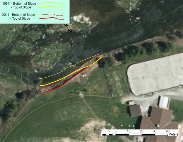
Concern with the receding river bank that borders along the north east boundary of the Fitzroy Harbour Community Centre (FHCC) property has been documented for a number of years. Since 1991, it is estimated that as much as 10 metres of land has been lost due to on-going erosion caused by a shift in the Carp River’s main channel. This loss of property has reduced the distance from the baseball diamond fence to the river bank edge from 18 metres to 8 metres at the nearest point in 2011. It has also resulted in the 5.0 metre high bank becoming near vertical. The resulting very steep slope poses a risk to public safety due to both a constant risk of failure and the drop down to a river and bedrock.
It is believed that the rate of erosion has been increasing in the past few years due to changes in the location of the river's main channel. Document 1 is the location diagram for the community centre, Document 2 illustrates the progression of the loss of property since 1991 and Document 3 shows the movement of the main channel from 1991 to 2011.
In response to this issue, Stantec Consulting Ltd was retained to carry out an Environmental Assessment (EA) study to develop alternative solutions and recommend a preferred solution. This report provides a summary of the EA study report with the recommended preferred solution. The full EASR is attached as Document 4.
DISCUSSION
Erosion protection works fall under Schedule "B" of the Municipal Class Environmental Assessment (Class EA), requiring the completion of Phases 1 and 2 of the Class EA Planning and Design Process. The scope of this process includes:
- Defining the Problem;
- Documenting Existing Conditions;
- Identifying, Evaluating and Selecting the Recommended Solutions; and
- Publishing a Notice of Completion.
Defining the Problem
A shift of the Carp River’s main channel over the past 20 years has resulted in ongoing erosion of the river bank that borders the Fitzroy Harbour Community Centre. Since 1991, erosion at the base of the bank has resulted in the repeated collapse of the bank face, making the bank face near vertical in some places and causing the top of slope to have receded approximately 10 metres.
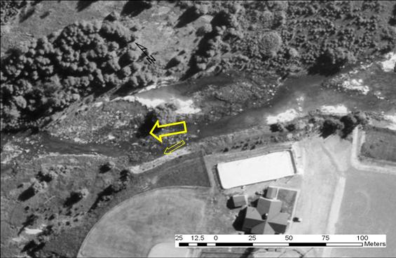
Document 3 shows how the main channel of the river has changed over time. In 1991, the main channel flowed through bars of deposited materials in the centre of the valley. Today, the new path of the main channel flows towards the bank, with seasonal large flow volumes and high velocities causing the clay banks to erode at a relatively high rate. The movement of the channel to the new location is reinforced by the relatively low bedrock where the channel is now located and increasing deposition in the now largely abandoned higher level channels through which it used to flow.
This situation presents a two-fold problem. First, the steep bank is a safety issue for the public. Second, the erosion, albeit a natural process, is resulting in a loss of property and the eroding bank is approaching the outfield fence of the ball diamond.
Documenting Existing Conditions and Contributing Factors
Fitzroy Harbour is just upstream from the mouth of the Carp River where the Carp River discharges into the Ottawa River. The Carp River watershed covers 307 km2 extending southwards from Fitzroy Harbour to the southern area of Kanata. The land use within the watershed is comprised of 34% agriculture, 40% of combined forest and wetland cover, and 26% within urban and village boundaries and rural roads.
The flows in the Carp River are dominated by the spring freshet resulting from snowmelt, with typically very low flows in August (2% of the April flows). Water quality has relatively high levels of phosphorus and E. coli. An extrusion of the Canadian Shield, Precambrian bedrock, is a dominant feature in the Carp River Watershed and indeed a unique feature within Ottawa. However, most of the Carp Watershed is founded in Palaeozoic bedrock, predominantly limestone and dolomite. Along the main valley of the Carp River is a deposition of clay, silt and sand.
The Fitzroy Harbour Community Centre property is located on a deep layer of varved clay overlaid on dolomite bedrock. The Carp River at the community centre flows along the bedrock, with areas of deposition within its banks. The south-western bank is defined by a 5.0 metre rise up a clay bank to the community centre property. The main channel of the Carp River now flows along a section of bedrock immediately adjacent to the referenced high bank that forms the edge of the community centre property. The area of the property most at risk contains an active baseball diamond that has been recently upgraded with lighting. The bedrock along the foot of the erosion site is approximately 1.0 metre lower than the bedrock where the main channel was previously located (1991).
Identifying, Evaluating and Selecting the Recommended Solutions
In addition to a ‘do nothing’ alternative, a number of alternatives were identified for addressing the erosion at the site. These alternatives are grouped into two major categories:
- Erosion Reduction; and
- River Re-training
In many situations the rate of erosion can be controlled by using approaches that provide more resistance to the erosive forces. These measures include lining the bank with rock – either in gabion baskets or rip-rap - or using ‘bio-engineering’ (vegetation using live plant materials with supporting structure). These approaches are appropriate where the major issue is low resistance to erosion with relatively low forces acting on the banks.
However, in the Fitzroy Harbour situation, the major factor is the re-direction of flow towards the bank, driven by the new route of the main channel and alignment of the bedrock. A long term solution requires the re-direction of the flow to reduce the energy imparted into the bank. Therefore, typical erosion reduction measures to protect the bank from erosion are not effective as they do not address the main cause of the erosion – the energy of the river directed towards the bank. Solutions to redirect the energy include:
· The use of groins – bands of rock extending out from the shoreline to deflect the flows away from the bank;
· Rebuilding the bank out to deflect the flows out to the original flow channels; and
· Rebuilding the bank out and cutting a deeper channel through rock – away from the bank to further ensure the long term location of the main flow channel.
Some of the solutions are problematic and are not natural features. Cutting through bedrock to create an alternate channel is expensive and will cause significant, short term, disruption.
Preferred Solution
The preferred solution is to re-establish the general form of the river to previous (1991) patterns. This solution incorporates recovery of a few metres of land at the top of slope, a stable vegetated slope at a 3:1 grade, a vegetated flood plain terrace, and rip-rap erosion protection along critical areas of the re-established bank. The re-alignment of the channel can be completed with relatively minor short-term impacts, resulting in long term stability and natural function.
The cost of works is estimated at $256,000 with design and supporting services estimated at $100,000.
Full details of the Environmental Assessment are provided in Document 4, Fitzroy Harbour – Carp River Erosion Control Class Environmental Assessment. Issues arising to be dealt with in detailed design and construction of works are included in Section 6.3 – Detailed Design, of the report.
Publishing a Notice of Completion
Subject to Council adoption of the Class EA recommendations, a notice of completion will be published to initiate the 30-day public review period.
ENVIRONMENTAL IMPLICATIONS
It is anticipated that the slope stabilization solution discussed in this report will reduce harmful erosion, increase slope stability, and improve fish habitat. Construction of the preferred solution will have some short-term impacts on the valley during the construction period as a result of the need for machinery to gain access to the site and move some local areas of deposition. However, these impacts will be minimized as much as possible through construction methods, proper sediment and erosion control, and re-planting of disturbed areas.
RURAL IMPLICATIONS
The preferred slope remediation solution discussed in this report will ensure that the Fitzroy Harbour Community Centre lands adjacent to the Carp River are stabilized and that both public safety and the function of the baseball diamond are ensured for the foreseeable future.
CONSULTATION
Public consultation for this project included the following:
i. Notice
of Study Commencement
A Notice of Study Commencement was advertised in the EMC West Carleton West Carleton Review on 29 September 2011 and distributed electronically to 270 subscribers of the Fitzroy Harbour Community Association (FHCA) mailing list. Information from the notice was incorporated in the FHCA’s print newsletter distributed to 350 homes in the Fitzroy Harbour area and posted on the FHCA website. Paper copies of the Notice were posted in the (Fitzroy) Harbour Store, on both Fitzroy Harbour Community Centre bulletin boards, and at the Fitzroy Harbour branch of the Ottawa Public Library.
ii. Open
House
An Open House was held on 26 October 2011 at the Fitzroy Harbour Community Centre to present the project to the public and request comments.
Advertising followed the same distribution as the notice of commencement, with the local paper advertisements appearing on 19 October 2011. A total of five people signed in for the open house. The verbal comments received were in support of addressing the problem.
iii. Agencies
The Mississippi Valley Conservation Authority has been directly involved in the project since it inception. The local offices of the Ministries of Natural Resources and Environment (MNR and MOE) have received a copy of the report and comments were discussed at a meeting held on 29 November 2011 at Fitzroy Harbour Community Centre.
COMMENTS BY THE WARD COUNCILLOR
Councillor Eli El-Chantiry: “On-going erosion caused by the Carp River is a public safety risk and will result in further loss of Fitzroy Harbour Community Centre lands unless addressed. I support the recommended mitigation solution as described in the report.”
LEGAL IMPLICATIONS
There are no legal impediments to implementing the recommendations of this report. Once the Notice of completion is published, the Study Report will be subject to a 30-day review period during which individuals may raise concerns and request a Part II Order be issued by the Minister of the Environment to elevate the status of the project (formerly referred to as a bump-up provision).
RISK MANAGEMENT IMPLICATIONS
There
are no legal/risk management impediments to implementing any of the
recommendations in this report.
CITY STRATEGIC PLAN
This project supports two Term of Council service / program priorities, Healthy and Caring Communities (HC2 Improve parks, recreation, arts and heritage) and Environmental Stewardship (ES2 - Enhance and protect natural systems). This project will remove risks to both public safety and to recreation facilities while following design with nature principles.
TECHNICAL IMPLICATIONS
There are no direct technical implications associated with this report.
FINANCIAL IMPLICATIONS
Funding
requirements for the detailed design and construction of the preferred solution
is estimated to be up to $360,000. Funds will be requested in the 2012 Capital
Rate Budget, 2012 Stream Restoration Projects.
ACCESSIBILITY IMPLICATIONS
SUPPORTING DOCUMENTATION
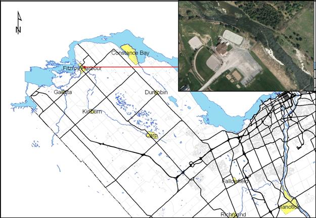
Document 1 Location Map Fitzroy Harbour Community Centre
Document 2 Loss of Land – Movement of Top of Slope 1991 and 2011
Document 3 Carp River Flow Paths 1991 and 2011
Document 4 Fitzroy Harbour – Carp River Erosion Control Class Environmental Assessment
(issued separately
to all Members of Council and held on file with the City Clerk.)
DISPOSITION
The Community Sustainability
Department will finalize the Environmental Assessment Study Report addressing
any comments received in the 30 day review period.
Subject
to the resolution of any concerns and the finalization of the Study Report, Infrastructure
Services will prepare and tender the detailed design and oversee the
construction of the works.
Location Map Fitzroy Harbour Community
Centre DOCUMENT 1
Loss of Land – Movement of Top of Slope 1991 AND 2011 Document 2
Carp River Flow Paths 1991 and 2011 Document
3
Major and Minor Flow Paths 1991
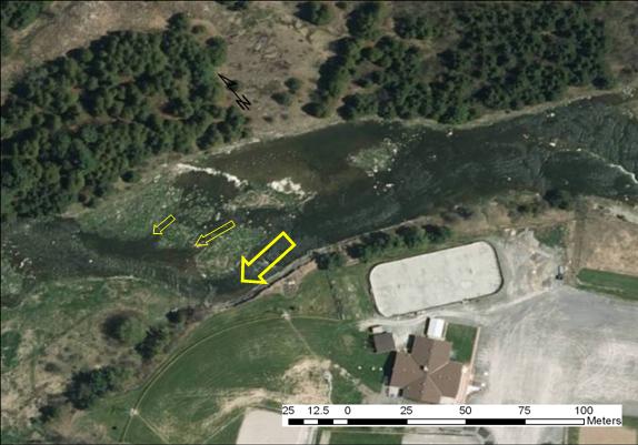 Major
and Minor Flow Paths 2011
Major
and Minor Flow Paths 2011