|
1.
ZONING – 2225 Mer Bleue
Road, Part of 2168 tenth line road and part of 2233 mer bleue road ZONAGE – 2225, chemin mer bleue, partie du 2168,
chemin tenth line et partie du 2233, chemin mer bleue |
Committee recommendation
That Council approve
an amendment to the Zoning By-law 2008-250 to change the zoning of 2225 Mer
Bleue Road, Part of 2168 Tenth Line Road and Part of 2233 Mer Bleue Road from
MC13, MC[1573] and R4A[1572] to MC[XXXX], as shown in Document 1 and as
detailed in Document 2.
Recommandation du comité
Que le Conseil
approuve une modification au Règlement de zonage 2008-250 pour changer le
zonage du 2225, chemin Mer Bleue, d’une partie du 2168, chemin Tenth Line et
d’une partie du 2233, chemin Mer Bleue de MC13, MC[1573] et R4A[1572] à
MC[XXXX], tel qu’il est indiqué dans le Document 1 et qu’il est précisé dans le
Document 2.
Documentation
1. Deputy City Manager's report,
Infrastructure Services and Community Sustainability, dated 1 February 2011
(ACS2011-ICS-PGM-0051)
Documents
Report to/Rapport au :
Comité de l'urbanisme
and Council / et au Conseil
01 February 2011 / le 01 février
2011
Submitted by/Soumis par :
Nancy Schepers, Deputy City Manager/Directrice
municipale adjointe, Infrastructure Services
and Community Sustainability/Services d’infrastructure et Viabilité des
collectivités
Contact
Person/Personne-ressource : Derrick Moodie, Acting Manager/Gestionnaire
intérimaire, Development Review-Suburban Services/Examen des projets d'aménagement-Services
suburbains, Planning and Growth Management/Urbanisme et Gestion de la
croissance
(613)
580-2424, 15134 Derrick.Moodie@ottawa.ca
REPORT RECOMMENDATIONS
That the Planning Committee
recommend Council approve an amendment to the Zoning By-law 2008-250 to change
the zoning of 2225 Mer Bleue Road, Part of 2168 Tenth Line Road and Part of
2233 Mer Bleue Road from MC13, MC[1573] and R4A[1572] to MC[XXXX], as shown in
Document 1 and as detailed in Document 2.
RECOMMANDATIONS
DU RAPPORT
Que le Comité de l’urbanisme
recommande au Conseil d’approuver une modification au Règlement de zonage
2008-250 pour changer le zonage du 2225, chemin Mer Bleue, d’une partie du
2168, chemin Tenth Line et d’une partie du 2233, chemin Mer Bleue de MC13,
MC[1573] et R4A[1572] à MC[XXXX], tel qu’il est indiqué dans le Document 1 et
qu’il est précisé dans le Document 2.
BACKGROUND
The
subject lands, 2225 Mer Bleue Road, Part of 2168 Tenth Line Road and Part of
2233 Mer Bleue Road, are located east of Mer Bleue Road, west of Tenth Line
Road, north of the Blackburn Bypass and south of the hydro and future rapid
transit corridor. These lands form part of the Mixed Use Centre designation in
the Official Plan and are subject to the Mer Bleue Community Design Plan (CDP)
and the Mer Bleue Mixed-Use Centre CDP.
Purpose
of Zoning Amendment
The
purpose of this Zoning By-law Amendment is to create an exception to the MC
Mixed Use Centre zone by adding a "Community Health and Resource
Centre" and a "Hospital" as permitted uses. In order to
facilitate the long term proposal for this site this exception will also add
“Parking Garage”, “Parking Lot”, “Residential Care Facility” and “Retail Store
limited to a pharmacy” as permitted uses.
This
amendment will allow the construction of the Orléans Family Health Hub facility
which will offer a variety of health services under one roof. It is anticipated that over the long term,
the Mer Bleue site could expand and transition from a "Community Health
and Resource Centre" to a "Hospital" and may provide services
similar to those offered at Hôpital Montfort.
A
0.5-hectare park is also proposed on the southeast quadrant of the site. This
park will eventually replace a temporary stormwater pond once storm sewers are
constructed and the pond is no longer required.
The future park will be connected to other uses on the site, as well as
the future transit station and the community to the east, via a pathway system.
Existing Zoning
The subject lands are zoned MC13 – Mixed-Use Centre Zone Subzone 13 and MC [1573] – Mixed-Use Centre Zone Exception 1573. Both zones allow a variety of uses which are envisioned in a Mixed-Use Centre designation including a park.
A small portion of this property is also zoned R4A [1572] – Residential Fourth Density Zone Exception 1572, which was established based on the approved draft plan of subdivision. However, through the severance process this land has been parcelled out slightly differently for conveyance to the Orléans Family Health Hub.
The existing mixed use zoning was created to allow a combination of transit-supportive uses such as offices, hotels, medical facilities, community recreation and leisure centres, day care centres, some retail uses, entertainment uses, plus services such as restaurants and personal service businesses and high density residential.
Proposed Zoning
This Zoning By-law amendment would
use the existing MC [1573] zone, retain the listed permitted uses which
includes a “park” and add a
"Community Health and Resource Centre", a "Hospital" , a
“Parking Garage”, a “Parking Lot”, a “Residential Care Facility” and a “Retail
Store limited to a pharmacy” as permitted uses.
It would also modify some of the zoning provisions to accommodate the
health centre proposal.
DISCUSSION
Official Plan
The Official Plan designates these
lands Mixed Use Centre. This land use designation provides for a wide
range of permitted uses and such locations are expected to form a focal point
of activity, both at the community and wider-city level. Transit supportive land uses are encouraged. From a land use perspective, the key goal is
a mixture of uses within a building or adjacent buildings. This could include institutional buildings,
as well as offices and high density residential uses.
Parking in the
Mixed Use Centre should be limited; however the Official Plan recognizes that
the minimum and maximum requirements for parking within this designation may
vary in response to the contextual influence of the geographic location of
individual Mixed-Use Centres and the stage of rapid transit development. As it is anticipated that the rapid transit
system and station will not be established in the near future, it is imperative
that sufficient parking is provided to allow for the community to access the
medical facility, particularly in an emergency situation, via alternative modes
of transportation. Even once the transit infrastructure is in place, adequate
parking will need to be maintained to accommodate this and other related uses
which will be developed in the future. However, the long term concept plan
shows the potential redevelopment of surface parking areas into parking
structures.
The Official Plan
encourages the establishment of usable areas of public space that support and
encourage informal social activity, recreation and civic gatherings. A 0.5-hectare park will be conveyed to the
City as part of this proposal through the site plan process. In the long term the park will serve the
neighbouring community and the site development which in the future may include
a residential care facility. The short term project is intended to also include
an outdoor landscaped courtyard in the centre of the building for use by staff,
patients and visitors.
The policies aim
to achieve transit-oriented development by functionally integrating transit and
the surrounding uses, enhancing accessibility to rapid transit stations with
recognizable pedestrian circulation systems that connect development with the
public transit system, is barrier-free and does not conflict with vehicular
movement systems. Through the site plan approval process the City will secure
an easement for a pedestrian pathway which will cross the site and link the
existing community to the park and to the future transit station. In the short
term, public access (north-south) will be provided through the building during
the facility’s operating hours which will connect the sidewalk along the
Blackburn Bypass with the north side of the site and eventually to the Mer
Bleue transit station.
Details
of Proposed Zoning
The proposed amendment would establish a site specific zone which would include most of the existing provisions in the parent MC zone and the MC [1573] zone. In order to facilitate the development of this health centre the following provisions listed in the MC [1573] zone will be removed: the maximum front yard setback for non-residential buildings, the minimum lot coverage, the glazing requirement on any of the building façades, the loading facilities in a yard abutting a residential zone, parking not permitted in a front yard or corner side yard and employment targets and community design guidelines provided in the Mer Bleue Mixed Use Centre Community Design Plan (CDP). The details of the zoning are shown in Document 2.
All of these provisions were included in the existing exception zone to reflect some of the requirements specified in this CDP. Given the nature of this proposed development, some of the provisions will not be achieved in the short term. However, it is intended that most of these guidelines will be implemented in the overall design of the future hospital site in the long term.
Mer Bleue Community Design
Plans
The Mer Bleue Community Design
Plan was approved by Council on May 24, 2006 which established a land use
framework to guide the future development within the Neighbourhood 5 community
between Mer Bleue Road and Tenth Line Road, south of the Hydro corridor and
future transitway. A Community Design
Plan for the Mixed Use Centre was also approved by Council October 25, 2006
which takes into consideration the existing conditions, defines specific
employment and residential targets and outlines urban design principles and
guidelines to accommodate a transit-oriented built form that minimizes impact
on the surrounding residential areas. In both CDP’s, the demonstration plans for the subject site
envisioned a pedestrian access way connecting the transit station and the civic
centre/park surrounded by mixed land uses, such as office, commercial and high
density residential located on a grid street pattern.
While the Mer Bleue Community Design Plan (CDP) did not envisage a
medical facility of this magnitude, the proposed creation of the Orléans Family
Health Hub meets many of the objectives outlined in the Mer Bleue CDP and will
be an important asset for the surrounding community and City as a whole.
Plan Objectives
The objective of the Mer Bleue Mixed Use Centre Community Design Plan is to have pedestrian and transit oriented development, compact urban form, provision for jobs and higher density residential development. The development is to have easy pedestrian access to the future Mer Bleue Transit Station from the surrounding residential community. This Mixed Use Centre CDP area forms part of a larger Mixed Use Centre which straddles the west and east side of Mer Bleue Road and is identified in the Official Plan. This designation applies to lands which have been strategically located along the rapid-transit network adjacent to major roads.
The CDP speaks to providing sidewalks, pedestrian connections and cycling linkages along major streets throughout the mixed use area. The roads serving the mixed use area are to be on the basis of a modified grid system and be integrated with the surrounding road network. Because of the proximity to the future transit station, consideration is to be given to reduced parking standards. At grade parking is to be discouraged and parking within structures and buildings encouraged. Urban design guidelines covering built form, streetscape, parking, connections, parkland, loading and utilities have also been included in the CDP.
Employment and Residential Uses:
The mixed use area east of Mer Bleue Road is intended to provide a minimum of 1500 jobs and 175 residential units in accordance with the Mer Bleue Mixed Use Centre Community Design Plan. In the long term, with the future expansion of this health facility, it is expected that both these employment and residential targets will be achieved.
Parkland
The CDP also requires that a 0.5-hectare parcel of land be dedicated to the City as a public park and demands strong pedestrian connections to the transit station and surrounding area. An interim pond will be required on site to manage stormwater run-off until storm sewers are constructed. Once this pond is decommissioned, a 0.5-hectare park will be conveyed to the City to serve the surrounding community and this development in the long term. In the short term the site will be designed with pedestrian linkages through the site from the residential neighbourhood to the future park and to the future transit station.
Compliance with the CDP
This proposal will deviate from some of the requirements in the Mer Bleue Mixed Use Centre CDP initially because instead of developing as several blocks on a plan of subdivision with local streets, the Orléans Family Health Hub will be constructed in phases on one large consolidated parcel of land.
In the interim, a minimum lot coverage of 50 per cent will not be attained because the development will be constructed in phases. However, in the long term it is expected that this will be achieved. In the long term it is anticipated that the expanded facility will include up to five new buildings which will be designed in consideration of the policies for built form and urban design in the Official Plan and Mer Bleue Mixed Use Centre CDP. Overall lot coverage will be increased, surface parking will be decreased with parking structures introduced, buildings will be oriented more to the internal private street system with reduced setbacks and abundant landscaping to create a more intimate streetscape and facilitate pedestrian and wheelchair accessibility throughout the site.
Traffic Issues
The existing and future road extensions surrounding the site will be able to accommodate the traffic circulation for this proposed development. In the future Mer Bleue Road will be widened to four lanes south to Renaud Road and the extension of the two northern lanes of the Blackburn Bypass to Mer Bleue Road is expected to be completed by 2012.
Transit services are expected to extend to the intersection of Mer Bleue Road and the Blackburn Bypass once construction of these roads is completed. The eastern extension of the transitway is not within the horizon of the 10-year Long Range Transit Capital Plan and therefore transit service to the site will be limited to bus routes along Mer Bleue Road and the Blackburn Bypass in the interim. In the long term, the expanded facility will be supported by planned improvements to the road network, the transitway and the Mer Bleue Transit Station.
Servicing Issues
The development of the site cannot occur until such time as proper servicing (water, storm and sanitary) is provided to the satisfaction of the City. The applicant has acknowledged this requirement.
CONSULTATION
Notice of this application was carried out in accordance with the City's Public Notification and Consultation Policy. The City did not receive any negative comments or opposition to this application.
COMMENTS BY THE WARD
COUNCILLOR(S)
Councillor Blais fully supports this zoning amendment and the project
as a whole. Establishing new health care facilities in the East end is a
top priority for residents in this community.
LEGAL/RISK
MANAGEMENT IMPLICATIONS
There are no legal/risk management implications associated with this report.
CITY STRATEGIC PLAN
The application is consistent with the
Planning and Growth Management priority which encourages the infill and
intensification of lands designated General Urban Area.
TECHNICAL IMPLICATIONS
FINANCIAL IMPLICATIONS
There are no direct financial implications associated with this report.
APPLICATION PROCESS
TIMELINE STATUS
This application was processed by the "On Time Decision Date" established for the processing of Zoning By-law amendment applications.
SUPPORTING
DOCUMENTATION
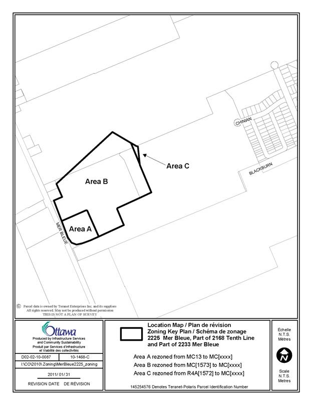
Document 1 Location Map
Document 2 Details of Recommended Zoning
DISPOSITION
City Clerk and Solicitor Department, Legislative Services to notify the owner, applicant, OttawaScene.com, 174 Colonnade Road, Unit #33, Ottawa, ON K2E 7J5, Ghislain Lamarche, Program Manager, Assessment, Financial Services Branch (Mail Code: 26-76) of City Council’s decision.
Planning and Growth Management to prepare the implementing by-law, forward to Legal Services and undertake the statutory notification.
Legal Services to forward the implementing by-law to City Council.
LOCATION MAP DOCUMENT
1
DETAILS OF RECOMMENDED ZONING DOCUMENT 2
1.
Rezone the subject lands shown on Document 1 from MC13, MC[1573] and R4A[1572]
to MC[xxxx]
Area A from
2.
Amend Section 239 to add a new exception [xxxx] as follows:
a. include
the following permission for uses from column IV of exception 1573:
All uses other than:
- amusement centre limited to a billiard establishment
- apartment dwelling, low rise
- apartment dwelling mid-high rise
- bank
- cinema
- community center
- convenience store
- daycare
- group home
- hotel
- library
- medical facility
- office
- park
- personal service business
- place of assembly limited to a club
- place of worship
- recreational and athletic facility
- restaurant
- retail food store limited to a bakery or a farmer’s market
- theatre
b. add the
following uses to the list of uses in column IV, having the effect of making
them permitted uses:
- community health and resource centre
- hospital
- parking garage
- parking lot
- residential care facility
- retail store limited to a pharmacy
c.
include the following provisions from column V of exception 1573:
- maximum building height- 10 storeys
- minimum density for apartment dwelling, low rise or apartment dwelling
mid-high rise- 80 units per hectare
- 4 metre wide landscaped buffer is required adjacent to a residential zone;
- 3 metre wide landscaped buffer is required between surface parking and the
transit corridor.
- all garbage, service and loading areas must be screened by a 2.4 metre high
wall or enclosure which is in keeping with the architectural treatment of the
main building.
- storage must be completely enclosed within a building
- in a parking area, a maximum of 20 parking spaces positioned side by side
without a landscaped island are permitted
- the minimum required width of a landscaped island is 2 metres
- the maximum required surface parking rate for office use is 3.7 spaces for
every 100m2 of gross floor area
- the minimum required surface-parking rate for retail stores is 3.45 spaces
for every 100m2 of gross floor area and the maximum rate is 3.85 spaces for
every 100m2
- the required parking rate may be reduced by 25%