Lansdowne Revitalization
Transportation Impact and Assessment Study and Transportation Demand
Management Plan
Terms of Reference
1
Background
Throughout
2009, Ottawa City Council provided incremental guidance and approval to the
Lansdowne Park Revitalization/Redevelopment Project, referred to as the
Lansdowne Partnership Plan (L.P.P.).
With regard to transportation, the related impacts and requirements of
the redevelopment proposal has also been addressed in increasing level of
detail as the process advanced.
The
most recent transportation analysis is contained in the 28 August 2009 report
prepared for the Ottawa Sports and Entertainment Group (OSEG) titled “Lansdowne Development Transportation
Strategy”. The key content of this
document, and its relationship to the City’s Official Plan and Transportation
Plan policy framework, were presented to the joint Transportation Committee and
Transit Committee on 08 October 2009.
At
a macro-level, the Transportation Strategy addressed two broad scenarios. One was the transportation-related impacts
and requirements of the estimated “day-to-day” activity related to the proposed
retail, office, residential and hotel land uses. The other was the transportation-related impacts and requirements
of the periodic “activities/events” in the Civic Centre and/or Stadium,
including any overlap with the ongoing daily activities. For both scenarios, the Transportation
Strategy identified:
·
the preliminary impacts and requirements of the LPP for all travel
modes in the context of previous Council direction and City policy;
·
a preliminary and innovative Transportation Demand Management Plan to
address travel requirements; and
·
transportation-related action items for further study, including the
need for a comprehensive Transportation Impact and Assessment (TIA) Study
consistent with the City’s Transportation Study Guidelines, but focussed on the
specific impacts and requirements of the LPP.
A copy of Chapter 6 of this report titled “Transportation Strategy and Related Action Plan” of the
Transportation Strategy is included as Attachment A to this Terms of Reference.
The key determinations related to
the Transportation Strategy, as reported to Transportation and Transit
Committee, were that:
·
The strategy embodies principles and directions of the Official Plan
(OP) and Transportation master Plan (TMP) in the context of City Council
Directions of April 22, 2009 which included:
o
revitalizing the stadium and Civic Centre;
o
reducing the hard surface area and increasing green and public open
space
o
enhancing links to pedestrian and cycle systems; and
o
advancing transit options.
·
The strategy focuses on day-to-day activities and special events;
·
The strategy builds on past experiences;
·
The strategy is high level – while a certain level of assessment had
been done to confirm that it can be made to work, additional detailed work
remains to be done, and develop a Transportation Management Plan for the LPP;
·
The additional work would be undertaken through a more detailed
Transportation Study;
·
Key areas where additional work is required as part of the study to
develop the Plan includes the following:
o
confirm availability of on-street parking;
o
secure arrangements with off-site parking lot owners (Carleton
University, Confederation Heights);
o
continued discussions with NCC to confirm opportunities/options
related to Queen Elizabeth Driveway;
o
determining specifics of transit and shuttle bus operational
requirements for various event sizes;
o
develop aggressive TDM promotional and communications initiatives that
would be rolled out for events.
City Council, at its November 2009 session,
approved and directed the conduct of a number of activities including a more
comprehensive Transportation Study undertaken in accordance with the
Council-approved Transportation Impact Study guidelines and the development of
a TDM Plan for the Lansdowne revitalization.
The Terms of Reference for this Study and for the TDM plan are provided
herein.
2
Development
Proposal
The land use details of the LPP
have evolved over the course of 2009 and will be refined in early 2010 for
input into the subject Transportation Impact Assessment. As a broad overview, the Lansdowne
revitalization will include:
·
a refurbished 24,000 seat open air stadium, with expansion potential
to 40,000 seats for unique special events;
·
a refurbished 11,000 person capacity Civic Centre;
·
general retail and possibly a food store and cinemas;
·
a Bank Street office tower;
·
a Bank Street hotel;
·
residential uses in the form of condominium apartments and possible
stacked townhomes along Holmwood; and
·
a design competition for the public realm “green” space at the east
end of the site between the stadium and the Rideau Canal, including integration
of the Horticultural Building, the Aberdeen Pavilion and providing a permanent
home for the Ottawa Farmers Market
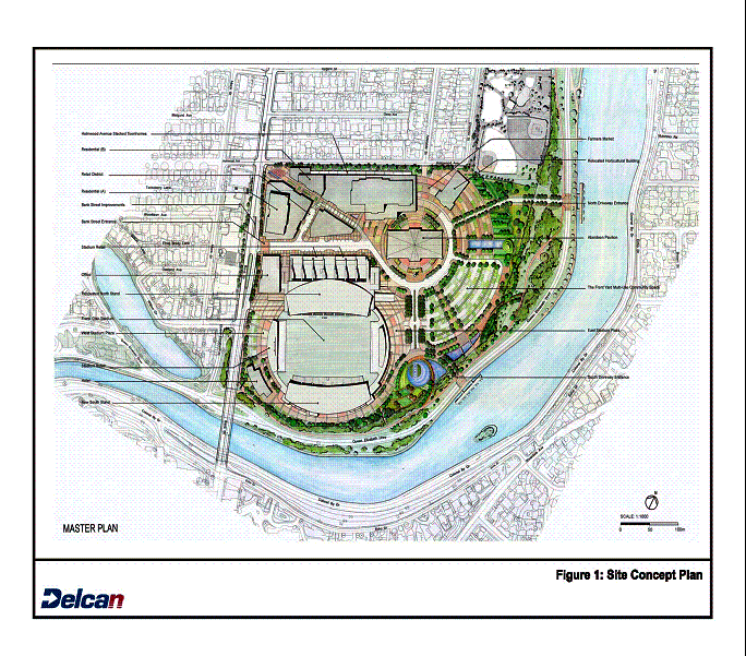
The
previous version of the Site Concept Plan that was included in the
aforementioned Transportation Strategy is included as Attachment B for general
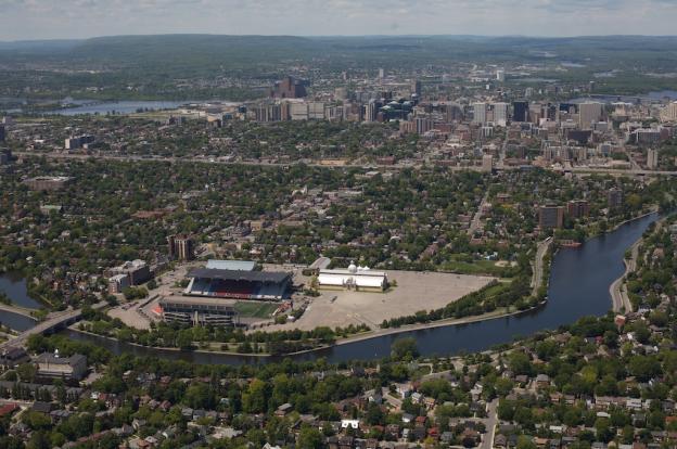
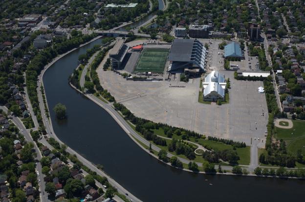
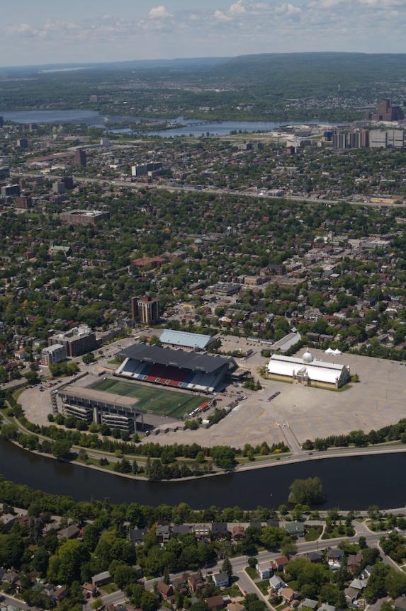
reference. Photographs of Lansdowne
Park in its local context are included as Attachment C.
3 Study Objectives
As
the revitalization program conditionally approved by Council in November 2009
will require a Zoning By-Law Amendment to permit uses to be located within the
new mixed-use development area (commercial, office, hotel, residential), the
City’s TIA Guidelines recommend the conduct of a comprehensive Community
Transportation Study (CTS) to address the proposal’s transportation impacts and
requirements.
As
there are two distinct components to the LPP (day-to-day activities and
periodic events), the overall objectives of the transportation analysis will
need to be different for each. The
focus of the “day-to-day” scenario will be the more traditional TIA assessment
looking at parking needs, site access issues, pedestrian/cyclist connectivity,
ability to accommodate traffic during peak periods, level of transit service
and modal share assumptions, and types of TDM initiatives to reduce single
occupant vehicles and increase other modes of travel.
The
focus of the “event” analysis would be to build upon the Transportation
Strategy and provide greater clarity around interventions needed to support
getting people to and from Lansdowne Park for different sized Civic
Centre/Stadium events. The focus would
be based upon increased local transit service, satellite parking and bus
shuttles, and the interventions required with regard to traffic operations,
parking prohibitions, emergency services, etc. and clearly demonstrating how
this would work and what the impacts/issues would be (such as additional bus
service on Bank Street, shuttle buses along Lakeview, potential use of QED,
on-street parking loss, etc.).
The
overlap analysis is essentially the cumulative impacts related to “day-to-day”
on-site activity when an “event” is also occurring at Lansdowne. This impact will be quantified, to the
extent possible, to allow an understanding of what this means with respect to
transportation issues and overall community (neighbourhood and business) impact
to allow Council to make determinations as to the acceptability of the traffic
impacts and overall impacts when giving consideration to giving its final
approval to the Lansdowne revitalization program and Partnership agreement with
OSEG.
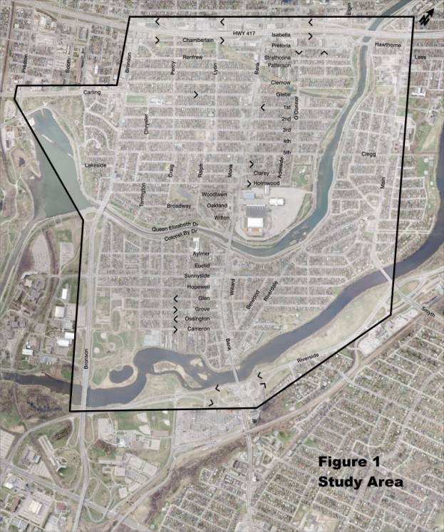
Within
this framework, and within a study area (Figure 1) bounded by Bronson Avenue
(including Queen Elizabeth Driveway to Preston Street), Highway 417, Main
Street and Riverside Drive, the objectives of the study will be to provide
professional transportation and transit planning services to produce a thorough
Transportation Impact Assessment, Transit Service Plan and Transportation
Demand Management Plan that address the relevant issues. The study area may extent beyond the area
described in Figure 1 to provide information to Council on traffic conditions
related to the various scenarios associated with the Lansdowne redevelopment.
4 Transportation Issues
The
following transportation issues, at a minimum, are to be addressed in the
respective aforementioned studies. At
the meeting with key community representative, held on January 26, 2010 at City
Hall to review these Terms of Reference, a number of issues were raised by
those in attendance prior to having the opportunity to thoroughly review the
Terms of Reference. The draft Terms of
Reference presented at this stakeholder meeting has been modified with this
final Terms of Reference including additional items to respond to the comments
provided dealing with the conduct and scope of the study. Other comments were reflected in the draft
Terms of Reference, and those that are more general in nature, have been
included as Attachment D. These will be
reviewed and addressed as appropriate during the conduct of the study.
·
Pedestrian – target modal share
(range), network connectivity, protected crossing of Bank Street (to/from bus
stops), crossing of Queen Elizabeth Driveway, on-site circulation and capacity;
interaction with general traffic; effect on an additional pedestrian bridge
across the Rideau Canal;
·
Cycling – target modal share
(range), network connectivity, on-site storage and crossing requirements along
Queen Elizabeth Driveway;
·
Transit Planning and Operations including – transit ridership forecasting (range),
evaluation of transit-priority measures on Bank Street, assessment of travel
time/delays; arrival/departure frequencies, bus storage requirements (where);
fleet/labour requirements; confirmation of off-site shuttle locations, routings
and facility requirements for all significant on-site activity combinations;
·
Traffic flow – evaluate area intersection
operation and performance, particularly in close proximity to the site;
evaluation of proposed traffic management measures; assessment of travel
times/delays; identify Highway 417 access routes; evaluate community traffic
infiltration (either avoiding congestion or searching for on-street parking
space) identify emergency response routes, particularly for major stadium
events, on-site and area circulation and interaction with pedestrian movements
– minimize conflict between pedestrians and vehicles especially buses;
·
Site access points – safe accommodation of
pedestrian, bicycle and vehicular traffic at all proposed site driveway
connections;
·
Parking – on-site capacity and related vehicle
access/egress and circulation; off-site parking capacity (on-street supply and
shuttle lot supply...varies by time and day); impacts of large Civic
Centre/Stadium events on on-street parking on study area primary streets, event
parking impacts on study area businesses and residents; and sufficient on-site
parking for Farmer’s Market;
·
Transportation Demand
Management –research TDM programs of other venues; establish range of potential
effectiveness; and recommend specific measures.
·
Other – taxi operations,
potential of water taxis on Rideau Canal, service vehicle impacts/requirements,
comparison to other stadiums of similar scale with respect to transportation
infrastructure.
·
Queen Elizabeth
Driveway –
recognition and accounting for the integrity, role, function of Queen Elizabeth
Drive as a signature and historical component of NCC parkway system; pedestrian
and bicycle crossing requirements.
5 Assessment
The
foregoing transportation issues can take on varying levels of significance
depending on the time of day, day of the week, and whether or not there is an
event occurring in the Civic Centre and/or the Stadium and the nature of any
activities/events occurring in the open space area. Each proposed on-site land use has its own unique traffic
generation, parking requirement, peak period of activity and combined transit
service requirement. Transit resource
requirements are also an important consideration when establishing event
timing. As such, the assessment to
determine impacts and to develop TDM strategies has to be given to the
following scenarios/time periods:
Day-to-day activities
·
office, hotel and residential commuter peaks - weekday (AM and PM peak
periods); and
·
retail peak – Saturday and/or Sunday (1:00-2:00 PM) and weekday
evening (6:00 – 9:00 PM).
Event
Activities
·
hockey - inbound peak – Friday (6:30 – 7:30 PM) or Sunday (1:00-2:00
PM) – Oct to April;
·
hockey outbound peak - Friday (10:00 – 11:00 PM) or Sunday (4:30 to
5:30 PM);
·
football/soccer inbound peak – weekday evening (6:30 – 7:30 PM) or
weekend (1:00-2:00 PM) – July to Nov;
·
football/soccer outbound peak - weekday evening (10:00 – 11:00 PM) or
weekend (4:30 to 5:30 PM);
·
large events – Friday evenings, Saturday or Sunday afternoon/evening;
·
NCC’s Rideau Canal programmed events (tulip festival, Winterlude,
etc.); and
·
Ottawa Farmers Market – Saturday/Sunday daytime.
Based
on the various combinations of land use activities that could impact overall
pedestrian, cycling, transit, parking and traffic solutions for the Lansdowne
revitalization, it will be necessary to identify the numerous combinations of
activities that have meaningful impacts and requirements. Likely scenarios include, but are not
limited to:
·
Scenario 1 – daytime including office, hotel, residential and retail
(AM Peak hour, PM peak hour and SAT peak hour);
·
Scenario 2 – weekday evening including significant retail (restaurant;
cinema) and with/without OHL Hockey (up to 10,000) [Friday evening];
·
Scenario 3 – full retail and CFL Football/soccer (up to 25,000)
[Saturday and Sunday afternoons and Friday evenings]; and
·
Scenario 4 – some retail (restaurant; cinema) and large event (up to
40,000) [weekend evening].
Note that the transportation
assessment of event activities will focus on arrival conditions at the site,
although consideration will also be given to departure conditions from the site
where data are available.
Where appropriate, the overlapping
effect of the Farmers Market and other programmed events for the site’s open
space will also be assessed.
6 Study Area
As
depicted on Figure 1, the study area, for purposes of the CTS, is generally
bounded by Bronson Avenue to the west (including Queen Elizabeth Driveway to
Preston Street), Highway 417 to the north, Main Street to the east and
Riverside Drive to the south. This area
defines the area where it is considered important to provide for an
understanding of expected traffic conditions related to the scenarios to be
examined. Should it be determined
through the conduct of the study, that additional analysis is required outside
this area, the additional analysis required will be undertaken consistent with
sound transportation engineering practice.
Within
the study area there will need to be different levels of focus and detail. The primary focus with regard to traffic
operations will be on Bank Street (Sunnyside to Glebe) and Queen Elizabeth
Drive adjacent to the site (Bank to Fifth).
Secondary focus will be on Bank Street (downtown to Riverside), Queen
Elizabeth Driveway (downtown to Preston) and Sunnyside (Bronson to Riverside).
With
regards to local streets, Holmwood Avenue and Fifth Avenue will be important
considerations due to their connectivity to Bronson Avenue and Queen Elizabeth
Driveway and their proximity to Lansdowne.
Glebe Avenue and Powell Avenue are also through connections between Bank
and Bronson as is Sunnyside which is a through connection between Bronson and
Riverdale. These streets are included in the area to be assessed and should it
be determined that they are potentially streets that will experience changes in
traffic conditions attributable to any of the assessment scenarios, they will
be examined in the level of detail required consistent with the City’s TIA
guidelines and sound transportation engineering practice. While all other local streets that are not
major connecting streets in the study area will be potentially impacted by the
larger scale events, quantifying the impact may be excessively challenging due
to the hundreds of block faces in the study area, the absence of existing
traffic data and inability to accurately estimate human driving patterns/behaviour
over such a large study area. The
consultant will use professional judgement to arrive at possible conclusions
with respect to potential impacts on local streets and to assist in this, will
undertake an analysis of some representative internal intersections to
determine current conditions and to undertake a sensitivity analysis.
7 Analysis Constraints
In
addition to the aforementioned constraints related to site traffic impacts on
an expansive local street network, other factors that will be of some constraint
and need to be acknowledged, include:
·
for the key intersections within the study area, only weekday peak
hour traffic counts are currently available at most locations. There are very few, if any, Saturday counts
available at key signalized intersections, there are likely no evening traffic
counts, and there are likely to be no counts for any time period at the
hundreds of local street intersections within the study area. The City will provide the consultant all
available traffic data for the study area’s local street network and will
undertake some additional counts where it is deemed important to have current
data. The analysis to assess the
various scenarios will, therefore, be based on a combination of data analysis
and professional judgement and qualitative assessment where there may not be
data; and
·
there is sometimes uncertainty with estimating auto, transit,
pedestrian and cycling trip generation from sporting events as it is a function
of modal shares arrival/departure patterns of patrons and auto occupancy. As such, plausible ranges for these key
variables must be considered to provide some level of sensitivity analysis with
regard to traffic impact, parking requirements and transit service requirements.
8 Work Plan
Requirements
To
meet the objectives of the Lansdowne Revitalization Program, this
Transportation Impact Assessment will require the completion of a number of
major tasks, appropriate consultation and preparation of deliverables. These are itemized, as follows, and are to
be considered the minimum requirements.
8.1 Major Tasks
Confirm Base Conditions
a)
confirm the uses/activities to be accommodated/provided for as part of
the Lansdowne Revitalization (uses and floor areas for new development, range
of Civic Centre and Stadium activities/events and times for these, programmed
activities/events for the open space area;
b)
confirm/formulate demand scenarios to provide a full range for
meaningful analyses;
c)
develop, in consultation with the City, data collection program
(including some local street intersections internal to adjacent communities)
required to establish baseline conditions for those time periods corresponding
to the above-noted demand scenarios (i.e. weekday evening; Saturday afternoon);
d)
update existing conditions analyses undertaken for the LPP
Transportation Strategy completed in August 2009 for additional time periods to
the extent reasonable;
e)
confirm, in consultation with the City, background traffic growth on
area roads;
f)
confirm, in consultation with the City, the horizon year for analysis
purposes;
g)
re-examine assumptions and estimates presented in the LPP
Transportation Strategy completed in August 2009 related to transit ridership
forecasting in order to confirm transit service requirements (includes
routings, stops, frequency, fleet/labour requirements) for each scenario,
including regular day-to-day operation;
h)
confirm, in consultation with the City, feasible targets for transit,
walk, cycle modal shares for each scenario, and confirm measures (including
TDM);
Assessment of Scenarios
i)
assess projected pedestrian activity and identify appropriate
network/intersection modifications (includes area circulation, requirement for
protected crossings (Bank Street and Queen Elizabeth Driveway), interaction
with other travel modes) for each scenario;
j)
assess projected bicycle activity and identify appropriate network
modifications (includes area circulation, requirement for facilities/amenities
including bike parking to support increased use of bikes, interaction with
other travel modes) for each scenario;
k)
confirm and assess shuttle operations (includes an evaluation of
travel time to/from shuttle locations and the impact of candidate transit
priority measures) for each scenario;
l)
assess traffic operations (includes an evaluation of projected
congestion levels on major study area road/intersections and develop
appropriate traffic management plans) for each scenario. Identify new traffic control measures, if
appropriate;
m)
liaise with City Project Manager for the Bank Street Reconstruction
project to maximize successful integration of the two projects with respect to
traffic operation, pedestrian crossing and storage accommodation, transit
service and urban design;
n)
assess traffic operations related to access/egress at the selected
satellite parking lots;
o)
for the off-site shuttles, determine functional requirements of the
related shuttle service including on-site operation, platform requirements and
bus routing to Lansdowne Park;
p)
for on-site bus loading/unloading during major events, confirm bus
access/egress requirements to/from Queen Elizabeth Drive and on-site bus
circulation and platform requirements.
Also, related pedestrian movement and queuing space requirements, and
crowd control to minimize pedestrian/vehicle conflicts;
q)
assess on-site and off-site parking needs to support each scenario in
the context of supporting increased use of non-auto travel for day-to-day and
for events/activities;
r)
assess on-site parking operations with respect to inbound processing
capacity (i.e., how quickly can vehicles be processed, where will queues form)
and outbound operations (i.e., how long to exit site after an event) including
minimizing vehicle/pedestrian conflicts.
Also address goods delivery and set-up requirements for events;
s)
estimate the loss of parking related to implementation of transit
priority measures;
t)
estimate of on-street parking demand related to various event sizes
and identify/quantify as best possible other off-street parking opportunities
in area including private property where zoning allows;
u)
for each scenario, consider development of a simulation model to aid
in the assessment of transit and traffic operations, and to provide
visualization of projected operations on Bank Street (Sunnyside to Fifth) and
Queen Elizabeth Driveway (Bank to Fifth);
v)
provide qualitative assessment of the traffic impact on the local
street network for each scenario;
w)
recommend appropriate event programming to minimize concurrent on-site
activities and to maximize the ability to provide good transit service and good
off-site shuttle service;
x)
for major events, identify Emergency Response Routes and the temporary
related loss of on-street parking, if any; and
y)
in conducting the foregoing tasks, the following issues and concerns
identified through the Fall 2009 community consultations will be responded to
and addressed through the conduct of the CTS, and where appropriate, as part of
the TDM plan to be developed.
o
Concerns about access and egress to the site including access to Bank
from Queen Elizabeth Driveway;
o
Desire to have access from Queen Elizabeth Driveway directly to and
from the site before the Bank Street Bridge, particularly if a hotel is
proposed for this corner of the property;
o
Desire to see right turn movements only from Wilton to Bank;
o
Concerns about pedestrian and cyclist safety along Bank, particularly
in relation to Wilton and Bank intersection;
o
Desire to have a footbridge from Old Ottawa East community to
Lansdowne;
o
Concerns about impact of transportation and parking on Sunnyside, Bank
(from Queensway through to Rideau River), in Old Ottawa East along Main Street
and St. Paul’s University campus;
o
Concerns about the impact of increased events on on-street parking
availability to residents, retail and restaurant customers;
o
Concern about late night traffic-generated noise pollution due to
conclusion of events after 11:00 p.m.;
o
Farmers Market wishes to have sufficient on-site parking for its
customers;
o
Glebe Community Association’s concern about impact of underground
parking access on-site on pedestrian flows along Bank; and
o
Concern about on-site truck deliveries, shipping and garbage removal
supporting retail, hotel and office development.
Determinations and Recommendations
z)
based on the findings from the foregoing analysis:
o
recommend appropriate network modifications to maximize pedestrian and
cyclist connectivity to the site and to support increased use of these travel
modes for day-to-day and event activity;
o
determine a transit operations plan to support day-to-day activity and
Civic Centre/Stadium events and activities for each scenario;
o
determine a traffic operations plan to support day-to-day activity and
Civic Centre/Stadium events/activities and to support the transit operations
plan;
o
recommend on-site and off-site parking operations and management
measures for each scenario.
o
determine, in consultation with OSEG and the Lansdowne Strategic
Design Review and Advisory Panel on-site circulation needs (site accesses,
parking facility access points, loading, etc.), that is focused on ensuring the
site is a pedestrian focused site;
o
recommend the appropriate level of TDM Plan and TDM measures for each
on-site land use; and
o
develop an implementation and performance/monitoring plan for all
events and the various combined event scenarios with regard to bus volumes,
on-street parking removal, traffic control, transit priority, street closures
and TDM measures.
8.2 Consultation
·
as required meetings with City project manager and support staff;
·
as required meetings with City Transit Services staff regarding transit
service options, requirements and impacts for combined site activities;
·
as required meetings with NCC staff on transportation matters related
to Queen Elizabeth Driveway as well as other transportation and transit options
and analyses;
·
as required meetings with Parks Canada staff on matters related to the
Rideau Canal;
·
as required meetings with community group/BIA representatives prior to
the study being finalized;
·
one presentation to NCC Executive Management;
·
one presentation to Transportation and Transit Committee; and
·
attendance at the Council meeting where the LPP will be considered.
8.3 Study Deliverables
Consultant
Deliverables
·
draft and final copies of the Community Transportation Study,
including a Traffic Impact Assessment for the proposed “day-to-day” activities,
a Transportation Strategy (requirements and impacts) related to Civic
Centre/Stadium “events”, a Transit/Shuttle Bus Plan for all activity scenarios,
a Traffic Operations framework for special events, and a Transportation Demand
Management Plan for all on-site uses/events; and
·
transportation-related exhibits and presentation material for:
o
local community/BIA representatives meetings; and
o
Committee/Council.
Services
to be Provided by the City of Ottawa
·
general direction of the Consultant in the provision of services, as
necessary;
·
any available plans, reports and other data pertaining to the project,
including intersection turning movement counts, parking data, transit data; and
·
transit planning assistance.
Timeframe
·
May 2010 (in advance of June 2010 Council).