STUDY AREA KEY PLAN Document 1
Report to/Rapport au :
Comité des transports
Submitted by/Soumis par : Ned Lathrop, General Manager/Directeur général,
Planning and Development/Urbanisme et Aménagement
Contact Person/Personne
ressource : Vivi Chi, Manager / Gestionnaire
Transportation Infrastructure / Infrastructure
des transports
(613) 580-2424 x21877, vivi.chi@ottawa.ca
REPORT RECOMMENDATIONS
That the Transportation Committee
recommend Council approve:
1. The study recommendation identifying Crawford Road (Alternative 5) as the second access to the Country Club Village (CCV) and Canadian Golf and Country Club (CG&CC).
2. The study recommendation of providing a
year-round static (non-piped) water supply within the Country Club Village
subdivision for fire services.
3. The finalization and filing of a Project File detailing the above noted recommendations of the Country Club Village and Highway 7 Service Road Access Environmental Assessment Study.
RECOMMANDATIONS DU
RAPPORT
Que le Comité des transports
recommande au Conseil municipal d'approuver :
1. la recommandation de l'étude dans
laquelle le chemin Crawford (option 5) est déterminé comme le deuxième chemin
de desserte au Country Club Village (CCV) et au Canadian Golf and Country Club
(CG&CC);
2. la recommandation de
l'étude selon laquelle on fournirait une réserve d'eau statique (sans
canalisation) dans le lotissement du Country Club Village aux fins de services
d'incendie.
3. l'étape finale et le dépôt
d'un profil de projet décrivant les recommandations susmentionnées de l'étude
d'évaluation environnementale sur l'accès par un chemin de desserte au Country
Club Village et à l'autoroute 7.
The City of Ottawa has undertaken the Country
Club Village - Highway 7 Service Road Access - Environmental Assessment (EA)
Study to address local service road access issues resulting from the Ontario
Ministry of Transportation (MTO) plans to widen Highway 7 from Highway 417 to
Carleton Place.
The analysis and study findings are described
in the subsequent sections of this report, and reflect the challenges that were
present in each phase of the study.
From the initial stages of the MTO study, and
now continued forward into this EA, there has been tremendous community
interest in the resolution of the access issue. Residents and other members of the public have devoted
significant time and energy in working with the study team to formulate a
solution. As such, the decision of the
study team to recommend (in essence) a “Do Nothing” option was not an easy one
to make. The issues discussed during the
study have ‘boiled down’ to a trade-off between travel time and the costs, both
financial and in terms of impact on a Provincially significant wetland.
Ministry of Transportation Highway 7 Widening
Project
In 1993 the MTO initiated an EA study to
address safety concerns for this heavily travelled section of highway. The
study was completed in 1996 with the recommended solution being to convert
Highway 7 from a 2-lane highway to a 4-lane divided freeway with interchanges.
One of the key study issues for landowners
adjacent to the Highway 7 corridor and the Township of Goulbourn was local
access and the provision of service roads. The reconstruction of Highway 7 to a
freeway configuration would necessitate all entrances and secondary roads to be
redirected to interchanges via adjacent service roads. During the
Highway 7 EA, the review and evaluation of local access issues considered
various ways to locate and direct the service roads to one arterial road or
another. Ultimately, service roads leading to the Hazeldean Road, Dwyer Hill
Road, and Ashton Station Road interchanges were recommended.
Highway 7, within the City of Ottawa, is
located predominantly within the former Goulbourn Township. The lands adjacent
to Highway 7 in this area are sparsely developed except for the rural estate
subdivision known as Country Club Village (CCV) and the adjacent Canadian Golf
and Country Club (CG&CC), both of which currently have direct access on to
Highway 7.
To address access needs for these two
properties, the Highway 7 EA identified a service road adjacent to Highway 7
extending from the Dwyer Hill Interchange eastward to the Canadian Golf and
Country Club, and ending at that location.
The Highway 7 service road, as planned, will introduce an average
3-minute increase in travel time (also called out of way travel) for trips to
the east from the Country Club Village.
During the Highway 7 EA, the former Goulbourn
Township identified a concern with this service road, and recommended that it
be extended to Jinkinson Side Road to reduce out-of-way travel and the response
time of emergency vehicles. In the
Highway 7 EA study, the service road extension was included in the evaluation
of alternatives but not supported due to the environmental impact on the
provincially significant Huntley Wetland Complex, significant construction
costs, and the relatively modest decrease in travel time. The Goulbourn Fire Service indicated, at the
time, that the emergency response times continued to be acceptable without the
service road extension.
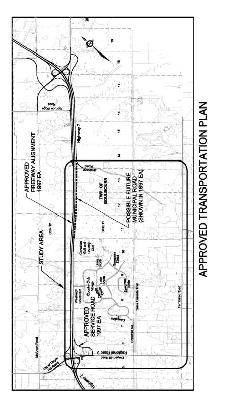
The residents of Country Club Village have continued to express their preference for this eastern extension to Jinkinson Road since this would facilitate the predominate direction of their daily trips. Goulbourn Township Council strongly supported the views of the residents in the interest of allowing the EA and its safety goals to move forward, requested MTO to include in its ESR highway plans the identification of the service road as a "possible future municipal roadway". The Township wanted to ensure that the service road issue could continue to be addressed, even after the Highway 7 EA process is completed. MTO concurred and shortly thereafter the Highway 7 EA was finalized. See Document 1 for the Study Area Key Plan.
Another key factor included in the original MTO review of service road alternatives was the evaluation of impacts on emergency response time. Comments received from the Goulbourn Fire Service in 1996 did not indicate significant concern with the expected change in emergency response time. However, in 1999 following the advertising of the Highway 7 EA Notice of Study Completion, new concerns were expressed by the Goulbourn Fire Service about the increased emergency response time to the Country Club Village.
Based on the Goulbourn Fire Service emergency
response time concerns, in 1999 the MTO agreed to co-fund this EA study (in
partnership with the then Goulbourn Township) to complete a detailed review of
emergency response time and local access issues related to the Country Club
Village and Canadian Golf and Country Club. Accordingly, in March 2002 the City
of Ottawa retained a consultant to conduct the Country Club Village and
Canadian Golf and Country Club Access Study.
The MTO contributed 50% or $62,750 of the original study budget of
$125,500. The final study costs are
projected to be approx. $160,000 due to additional work added during the study.
In the meantime, the MTO has continued to move
forward with preparations for the reconstruction of Highway 7 in parallel with
this study. Detailed design is underway
and construction will follow depending on the availability of funding and
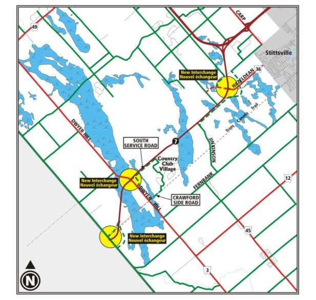
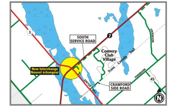
provincial priorities. See Document 2 for the Local Area Key Plan.
DISCUSSION
The purpose of the access study, in
consideration of the eastern extension of the service road, was to:
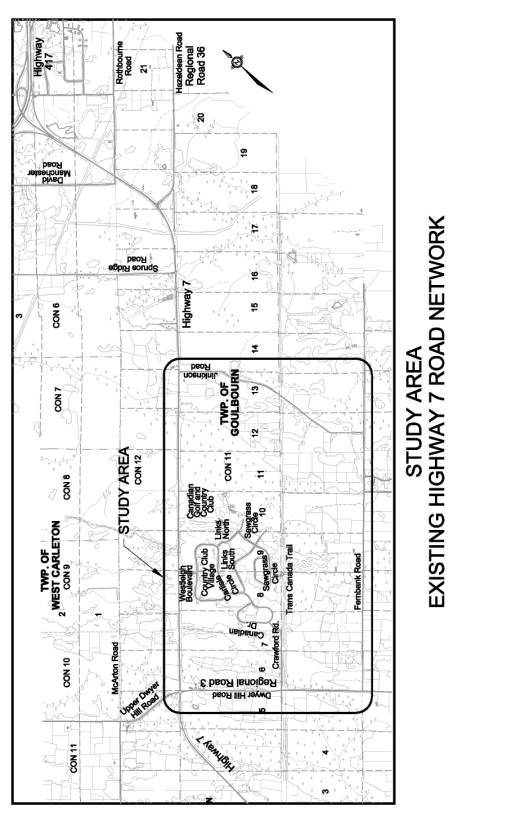
The existing transportation network, as
illustrated in Document 3 – Study Area, includes the following
transportation facilities:
The Official Plan and the Highway 7 EA Study,
both completed and approved either prior to or during this study, define the
future transportation network. The
analysis, therefore applied the approved planning as the base case for all evaluation
of alternatives. It should be noted
that the CCV participants in this study continue to view the existing
conditions as the representative baseline, rather than the previously approved
planning.
The future approved transportation network, as
illustrated in Document 4 - Approved Transportation Network, will
include the following changes from existing (2004) conditions:
A shift in the new highway alignment to the
north in the vicinity of the CCV and CG&CC was recommended as part of the
planning process to minimize impacts (visual, noise, etc.) on the homes that
back onto Highway 7 and to avoid disruption to the golf course.
The introduction of freeway features will
provide greater safety with the removal of at-grade intersections and opposing
lanes.
The future transportation network will require
vehicles, including emergency services, that may originate from the east to
travel to the Dwyer Hill Road interchange and travel back along the local
service road. The higher operating
speeds on the freeway (100 km/hr) will partially offset the longer travel distance
on the local road network. In addition,
local road access is available via Fernbank Road and Dwyer Hill Road.
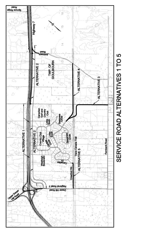
Alternatives Considered
The five alternatives included:
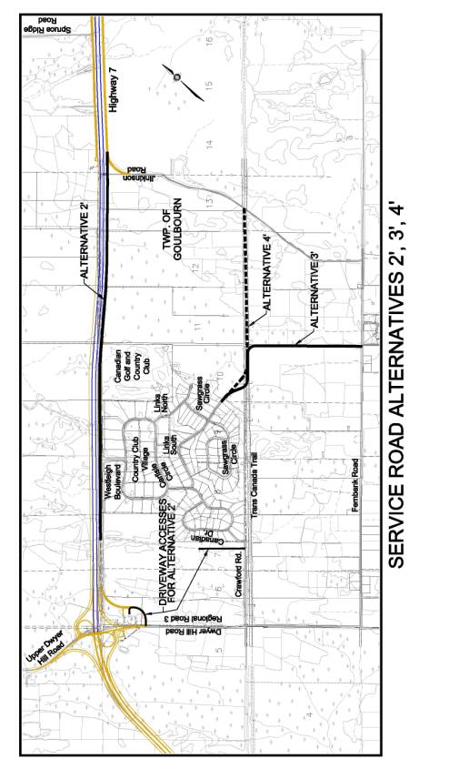
Following the evaluation exercise with the
Public Advisory Committee (PAC) members, variations on Alternatives 2, 3 and 4
were developed and evaluated with the other alternatives. The variations applied to both the fire
response and community access alternatives.
The revised alternatives included:
The service road alternatives 1 to 5 are
illustrated in Document 5, and service road alternatives 2`, 3`, and
4` are illustrated in Document 6.
One of the key goals of this study was the
examination of fire response to the CCV and CG&CC.
The study review of alternatives found that
Alternative 5 provides a better response time to the center of the CCV
community (14 minutes and 42 seconds) than existing conditions of today
(14:49). Alternative 5 was considered
an acceptable fire response time by City of Ottawa Fire Services and formed the
study recommendation based on its low cost to implement and negligible impact
to the natural environment.
Alternative 3 and Alternative 2 both provide
better fire response times to the CCV community than Alternative 5. However the cost and environmental impacts
required to improve on the acceptable response time of Alternative 5 is
considered too great to warrant recommendation.
Each of the Alternatives were evaluated with
the assumption that the Highway 7 widening will be in place. A complete table of Fire Response
Comparisons for each alternative is shown in Document 7.
One of the community’s primary concerns during
the study was the increased travel time for residents of the Country Club
Village and patrons of the Canadian Golf and Country Club. The recommended Alternative 5 maintains the
same out-of-way travel for CCV residents (3:16) as was identified in the
approved Highway 7 EA planning. If
compared to existing (today's) conditions, Alternative 5 represents a 30%
increase (from 10:56 to 14:12) in travel time to Stittsville and a 23% increase
(from 13:49 to 16:10) in travel time to Kanata. The impact on trips will
decrease proportionally for destinations further east such as downtown Ottawa.
Alternative 2 does provide improved travel time
to Stittsville (10:48) and to Kanata (14:38), but there is a cost (financial
and significant environmental) to implement this alternative.
A complete table of Community Travel Time
Comparisons for each alternative is shown in Document 7.
The out-of-way travel to the golf course is the
largest travel time impact that is not reduced by the recommended Alternative
5. The serviced road identified and
approved in the Highway 7 EA will require guests arriving from the east to
travel approximately 2 km further than provided today. As an example, this results in a 33%
increase in travel time from Kanata.
Golfers arriving from the east are the majority of the course’s
patrons.
The TAC considered this issue and included it
in the evaluation exercise. However,
the review of travel time impacts was weighed against two important
factors. Firstly, the golf course has
an agreement (1972) with the MTO that pre-contemplates and accepts the loss of
direct access to Highway 7 as a condition of the initial approval for the golf
course entrance. Secondly golf course
patrons are generally making destination trips and are aware of the location of
the course before booking a "tee-off" time, and therefore can
effectively plan for the additional travel time.
The possible air quality impacts of the
additional travel time to the golf course were also considered and determined
to be an inappropriate measure to gauge the need for modifications to low
volume local roads. When compared to
air quality issues related to major high volume roads elsewhere in the City,
the marginal benefits available from similar levels of investment on major
roads far exceed the potential for any real air quality benefits in the
relatively low volume local road context.
A complete table of Canadian Golf and Country
Club Travel Time Comparisons for each alternative are shown in Document 7.
Wetlands are essential components of ecosystems
that contribute to the high quality of the environment in Ottawa. Wetlands control and store surface water to
assist in flood control, act as sediment traps to improve water quality, and
provide habitat for a wide variety of plant and animal species and may serve as
recharge areas for groundwater resources.
The Ministry of Natural Resources has developed
a system that evaluates the biological, social, hydrological and special
features of wetlands to determine their relative significance in Ontario. The Huntley Wetland Complex has been
evaluated and identified as a Provincially Significant Wetland. Impacts on Provincially Significant Wetlands
are avoided whenever possible and only considered where other reasonable
alternatives do not meet essential needs.
The Huntley Wetland Complex is identified in the OP as a Significant
Wetland.
The PAC’s overall preferred solution,
Alternative 2, crosses the Huntley Wetland Complex. However, some members of the PAC have defended the ecological
values of this area and support the study's technical recommendation
(Alternative 5).
The MTO has indicated (October 2003) that it is
willing to fund 75% of the total construction cost for the final MOE approved
solution arising from this EA.
Depending on which alternative is endorsed, potential funding from the
MTO would result in the following approximate costs to the City:
At the final Public Open House on 14 October
2003 the Country Club Village Community Association indicated that they had
been in contact with Thomas Cavanagh Construction Ltd. and arranged for the
donation of road building materials for Alternative 2.
Thomas Cavanagh Construction Ltd. has provided
a letter offering the donation of rock for the construction of an Alternative 2
road base. The approximate value of
this contribution is $50,000 ($37,500 of this would be the MTO share of this
alternative). A review of the
evaluation of alternatives by the TAC has indicated, based on the weighting of
the various factors including cost, that Alternative 5 remains the recommended
alternative of the study.
EVALUATION CRITERIA AND PROCESS
Both the TAC and PAC completed the technical
review and evaluation exercise.
The PAC requested and completed a separate
weighting exercise from the TAC and recommended Alternative 2 (Service Road
along Highway 7 from Dwyer Hill Road to Jinkinson Road). The TAC's recommendation is Alternative 5
(Crawford Road).
The difference in perspective of the two groups
of evaluators (TAC and PAC) is illustrated in a Comparison of PAC and TAC
Weights table found in Document 7. Documents
8 and 9 provide further
comparisons of TAC and PAC opinions as
well as comparisons of alternatives.
Alternative 2 is the preferred solution for the
adjacent community in that it improves access for the existing approximately 90
homes and the golf course. The TAC and
study team have not endorsed this solution due to the higher costs ($1.4
million), and impacts to a provincially significant wetland.
Community representatives have noted that they
will be asking the Committee to change the recommendation of the study, and
utilize funding from the MTO and any private business contribution to reduce
the cost of the project to the City.
Sensitivity Testing
A sensitivity testing exercise was completed to
test the range of perspectives of the TAC and PAC. This allowed the study team to assess how robust the preferred
solution was between the two groups as well as whether there were differences
among individual members on each committee.
The results of the sensitivity testing showed
the TAC was generally in agreement with selecting Alternative 5. It was selected as the preferred Fire
alternative by the committee, rated first in 8 of 12 sensitivity tests for Fire;
rated first for Community Access and rated first in 8 of 12 sensitivity tests
for Community Access. When rated as a
"Balanced Need" the TAC selected Alternative 5 and it was the
individual choice of 11 of the 14 TAC members.
The results of the sensitivity testing showed
the PAC was generally in agreement with selecting Alternative 2. It was selected as the preferred Fire
alternative by the committee, rated first in 7 of the 12 sensitivity tests for
Fire; rated first for Community Access and rated first in 9 of 12 sensitivity
tests for Community Access. When rated
as a "Balanced Need" the PAC selected Alternative 2 and it was the
individual choice of 8 of the 11 PAC members.
The conclusion of the sensitivity testing
exercise was that there was polarity of perspectives between the two groups. Those that live in the community have a
preference for attributes of reduced travel time.
RECOMMENDED SOLUTION
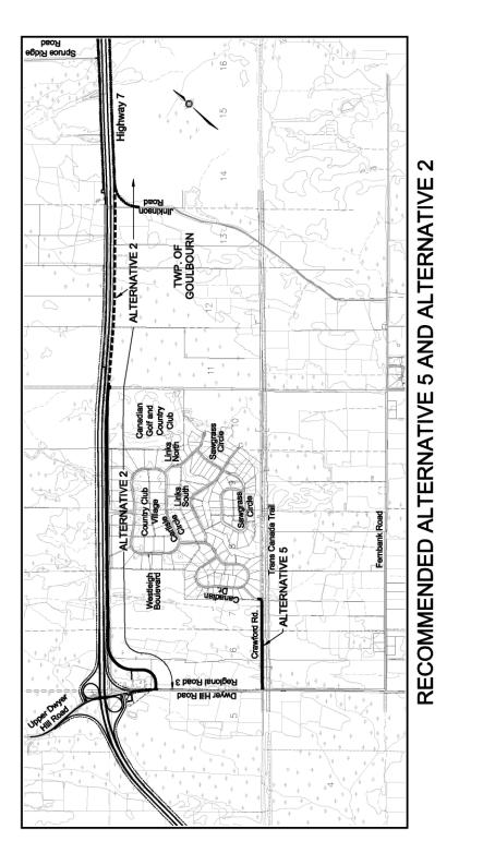
The study recommendation is Alternative 5
(Crawford Side Road), as shown in Document
10. Alternative 5 provides a road
link from Dwyer Hill Road to the south portion of the CCV via Crawford Side
Road. This recommendation also
incorporates the previously approved service road from Dwyer Hill Road along
Highway 7 to the eastern limits of the CG&CC as proposed in the MTO highway
widening project.
This recommendation was developed based on the
following issues:
·
The acceptance
from senior fire officials that this alternative met acceptable fire response
standards for rural response times;
·
It does not
introduce any new impact to the natural environment since the construction of
Crawford Road is already underway within the road allowance; and
·
It does not
impose additional road construction costs on the City since the developer of
the CCV is required to construct the road in accordance with a development
agreement. Current schedules indicate that the construction of the service
road, begun in the fall of 2003, will be completed in 2004.
During the course of the study regular update
meetings were held with the Technical Advisory Committee (TAC) and Public
Advisory Committee (PAC).
The TAC was composed of representatives from
the City of Ottawa (including emergency services), Ministry of Transportation,
Ministry of Natural Resources, Mississippi Valley Conservation Authority and
consultant staff.
The PAC was comprised of representatives from
community associations (Country Club Village Community Association and
Northwest Goulbourn Community Association), Canadian Golf and Country Club,
Friends of the Jock River, Goulbourn Wetlands Advisory Committee, Ottawa
Cycling Advisory Committee and a local farming operation. The PAC participants have invested
significant time and effort on the study.
A Value Planning Workshop was held as part of
the public consultation program. The
workshop included participation from all stakeholders including the TAC, PAC
and external agencies with interest in the study. The Value Planning workshop defined all issues and participants
brainstormed ideas for improving transportation service to this part of the
City.
In addition to the TAC and PAC meetings and
Value Planning Workshop, two Public Open Houses were conducted to present the
study and its findings to the general public.
The first Open House was held on 12 September 2002 at which the study
process, existing conditions, alignments options, issues and next steps were
presented for public review and comment.
The second Open House, held on 14 October 2003, presented the
technically preferred alternative for the study. Summaries of these Open Houses were provided to the Ward
Councillor, and members of the PAC and TAC.
The Public Open Houses were advertised in local
and community papers. Flyers were
distributed to homes in the community and within the study area
boundaries. The meetings drew an
attendance of 45 and 61 visitors at the first and second Open Houses
respectively.
Although there is general agreement that
protection of wetlands is important, a large proportion of the residents
strongly support Alternative 2.
FINANCIAL IMPLICATIONS
The study recommendations include the construction of
a new static (non-piped) fire water supply point in the CCV with an estimated
cost of $50,000.
The MTO cost sharing agreement calls for
funding up to 75% of the MOE approved recommended option (capital costs
only). The MTO have been asked to
confirm that this funding scenario can include the recommendation to provide an
improved fire water supply point. The
City's share (from $12,500 to $50,000 depending on funding) for the construction
of this water supply point will have to be identified in a future budget.
The previous subdivision approval anticipated the maintenance cost for Crawford Road, now estimated to be in the order of $ 6,000 per year.
SUPPORTING DOCUMENTATION
Document 1 - Study Area Key Plan
Document 2 - Local Area Key Plan
Document 3 - Existing Transportation Network
Document 4 - Approved Transportation Network
Document 5 - Service Road Alternatives 1, 2, 3,
4, 5
Document 6 - Service Road Alternatives 2`, 3`,
4`
Document 7 - Tables
Document 8 - Comparison of PAC and TAC Opinions
Document 9 - Comparison of Alternatives 5, 3
and 2
Document 10 - Recommended Alternative 5
DISPOSITION
Following Committee and Council approval, the Project
File documenting the entire environmental assessment process and study
recommendations will be prepared and filed for the 30-day public review period,
in accordance with the provincial Environmental Assessment Act.
Once the formal review period is over and if
there is no Part II Order request to the Minister of the Environment
(previously known as a request for a ‘bump-up’ to a higher level of study), the
project study will be considered approved.
The recommended extension of Crawford Side Road to Dwyer Hill Road as a collector road with the appropriate right-of-way protection will be included in the appropriate schedule(s) of the City's Official Plan. The extension of Crawford Side Road to Dwyer Hill Road is under construction by the developer for completion in 2004, and no additional road construction will be required by the City.
STUDY AREA KEY PLAN Document 1
LOCAL AREA KEY PLAN Document 2
STUDY AREA Document 3
APPROVED TRANSPORTATION NETWORK Document 4
SERVICE ROAD ALTERNATIVES 1, 2, 3, 4, 5 Document 5
SERVICE ROAD ALTERNATIVES 2`, 3`, 4` Document
6
TABLES Document
7
|
Table 1 Fire Response
Comparisons |
||||
|
Alternative |
CCV (Existing
Homes) |
CCV (Future
Homes |
CCV (Homes
Average) |
CGCC |
|
Existing (2003) |
14:43 |
14:55 |
14:49 |
11:47 |
|
Alt. 1 (1997
MTO Baseline) |
15:55 |
16:07 |
16:01 |
14:00 |
|
Alternative 5 |
15:11 |
14:13 |
14:42 |
14:00 |
|
Alternative 3 |
12:04 |
12:51 |
12:28 |
12:21 |
|
Alternative 2 |
13:53 |
14:04 |
13:58 |
11:03 |
|
Table 2 CCV Travel Time Comparisons |
||
|
Alternative |
CCV to Stittsville |
CCV to Kanata and East |
|
Existing (2003) |
10:56 |
13:49 |
|
Alt. 1 (1997 MTO Baseline) |
14:12 |
16:10 |
|
Alternative 5 |
14:12 |
16:10 |
|
Alternative 3 |
12:11 |
16:10 |
|
Alternative 2 |
10:48 |
14:38 |
|
Table 3 Canadian Golf
and Country Club Travel Time Comparisons |
||
|
Alternative |
CG&CC to
Stittsville |
CG&CC to
Kanata and East |
|
Existing (2003) |
7:57 |
10:49 |
|
Alt. 1 (1997
MTO Baseline) |
12:28 |
14:26 |
|
Alternative 5 |
12:28 |
14:26 |
|
Alternative 3 |
12:28 |
14:26 |
|
Alternative 2 |
7:48 |
11:38 |
|
Table 4 Comparison of
PAC and TAC Weights |
||
|
Issue |
PAC |
TAC |
|
Fire Response |
18 |
36 |
|
Natural Habitat |
17 |
21 |
|
Access |
46 |
9 |
|
Land Use &
Property |
11 |
7 |
|
Cost |
1 |
20 |
|
Other Factors |
7 |
7 |
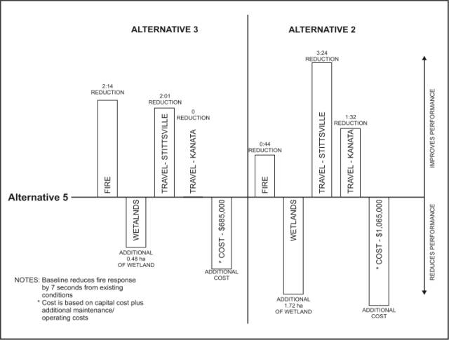
The
evaluation of the two groups (TAC and PAC), have resulted in two different
preferred solutions. The PAC, speaking
for the community, have a preference for Alternative 2. Alternative 2 provides the best performance
for community travel issues. The TAC
preference is for a solution that provides some improvement in performance with
no cost or environmental impact.
The
level of performance and associated costs are graphically shown below. The detailed comparison of the trade-offs of
all competing criteria are presented on the Resource Table.
![]()
![]()
![]()
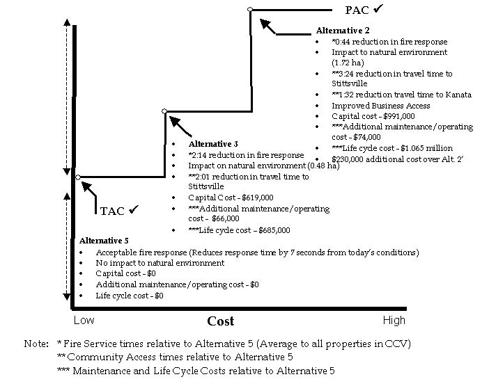
COMPARISON OF ALTERNATIVES 5, 3 AND 2 Document 9
RECOMMENDED ALTERNATIVE 5 Document
10