Report to/Rapport
au :
Transportation
and Transit Committee
Comité des transports et des
services de transport en commun
27 August 2003 / le 27 août
2003
Submitted by/Soumis par : Rosemarie
Leclair, General Manager/Directrice générale,
Transportation, Utilities and Public Works/Transport, services et travaux
publics
Contact Person/Personne ressource : Michael J. Flainek,
P.Eng., Director/Directeur
Traffic
and Parking Operations Branch/Circulation et Stationnement
(613)
580-2424 x 26882, Michael.Flainek@ottawa.ca
|
Ref N°: ACS2003-TUP-TRF-0033 |
REPORT
RECOMMENDATIONS
That
the Transportation and Transit Committee recommend Council approve the
following work to accommodate the Riverside South Urban Community:
1.
The construction
of the intersection of Limebank Road and Spratt Road that includes the
provision of a northbound left-turn lane, a southbound right-turn lane and the
installation of traffic control signals;
2.
The closure of
the Temporary Road linking River Road and Shoreline Drive to motor vehicle
traffic including the retention of a portion of this road link for pedestrian
and cyclist usage, the removal of the southbound left-turn lane on River Road,
and the conversion of the existing traffic control signals for the exclusive
use of pedestrians and cyclists crossing River Road; and,
3.
The installation
of traffic control signals at the intersection of Earl Armstrong Road and River
Road.
Providing that the
proponents, Richcraft South Growth Incorporated and 172497 Canada Incorporated:
a. Enter
into a Road Modification Agreement with the City of Ottawa, which will include
but not be limited to the following conditions:
·
All costs associated
with the design and construction of the above-noted roadway modifications and
traffic control installation and any related works are to be at the expense of
the proponents;
·
The annual costs
to maintain the proposed traffic control signals at Limebank Road and Spratt
Road in accordance with Council policy are to be at the expense of the
proponents until traffic control signals become warranted; and,
b. Provide
financial guarantees acceptable to the City to cover the above-noted road
works.
RECOMMANDATIONS DU RAPPORT
Que le Comité des transports et des services de
transport en commun recommande au Conseil municipal d’approuver les travaux
suivants afin de répondre aux besoins relatifs à la croissance de la communauté
urbaine Riverside Sud :
1.
La construction d’une intersection située à l’angle des chemins Limebank
et Spratt qui comprend l’aménagement d’une voie de virage à gauche en direction
nord, une voie de virage à droite en direction sud ainsi que l’installation de
feux de signalisation;
2.
La fermeture aux véhicules motorisés de la voie temporaire effectuant la
liaison entre le chemin River et la promenade Shoreline, ce qui comprend la
conservation d’une section de la voie de liaison pour les piétons et cyclistes,
le retrait de la voie de virage à gauche en direction sud du chemin River ainsi
que la transformation des feux de signalisation en feux destinés exclusivement
aux piétons et cyclistes traversant le chemin River; et,
3.
L’ installation de feux de signalisation à l’intersection des chemins
Earl Armstrong et River.
Étant entendu que les promoteurs, Richcraft South
Growth Incorporated et 172497 Canada Incorporated :
a. Signeront une entente de modification de route avec la Ville d’Ottawa, laquelle comportera les conditions suivantes, mais ne se limitera pas à ces dernières :
·
Tous les coûts liés à la conception et à la construction des
modifications de la chaussée décrites ci-dessus ainsi qu’à l’installation des
feux de signalisation et aux travaux connexes devront être défrayés par les
promoteurs; et,
·
Les coûts annuels d’entretien des feux de signalisation proposés à
l’intersection des chemins Limebank et Spratt en vertu de la politique du
Conseil municipal devront être défrayés par les promoteurs;
b. Fourniront
des cautionnements financiers jugés acceptables selon la Ville afin d’assurer
les travaux routiers décrits ci-dessus.
BACKGROUND
Richcraft
Homes Limited and Urbandale Corporation are currently developing the Riverside
South Urban Community (RSUC), an area bounded by Leitrim Road to the north,
Earl Armstrong Road to the south, Limebank Road to the east and River Road to
the west. A condition of the agreement
between the City and the developers for this subdivision (registered in 2001)
identified that at a threshold of 1,200 building permits issued, the developers
would at their cost:
·
Remove the existing
Temporary Road linking Shoreline Drive to River Road; and,
·
Construct an easterly
extension of Spratt Road to intersect with Limebank Road.
This
building permit threshold was realized recently.
It
is recognized that the majority of the commuters traveling on River Road who
currently use the Temporary Road to access Shoreline Drive in the subdivision,
will in the immediate future use Spratt Road south by way of the intersection
of River Road and Earl Armstrong Road.
The reassignment of these traffic volumes will necessitate the immediate
installation of traffic control signals at the intersection of River Road and
Earl Armstrong Road.
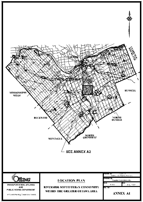
Annex
A1 is a Location Plan that shows this community in the context of the greater
Ottawa area.
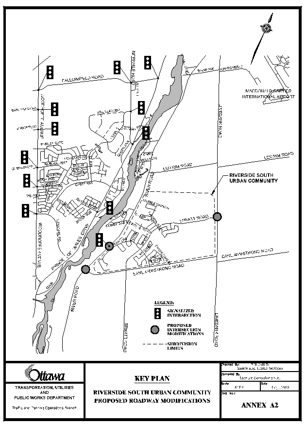
Annex
A2 provides a Key Plan that shows the Riverside South Urban Community
Subdivision along with the locations of the proposed roadwork.
DISCUSSION
Existing Conditions
River Road, Limebank Road and Earl Armstrong Road are all two-lane
undivided rural arterial roadways with posted speeds of 80 km/h, 80 km/h and 60
km/h respectively.
Both River Road and Earl Armstrong Road have paved shoulders.
Spratt Road is a four-lane undivided urban collector roadway with a
posted speed of 50 km/h. Its southern
terminus “tees’ into Earl Armstrong Road, and from there it meanders northeast
through the RSUC. Construction is
underway to complete the final 800m of roadway to connect its easterly terminus
to Limebank Road as a “tee” intersection.
While Spratt Road has street lighting designed to City standards, the
arterial roadways only have street lighting at major intersections.
The three intersections that are the topic of this report are the future
intersection of Limebank Road at Spratt Road, and the existing intersections of
River Road at Temporary Road, and River Road at Earl Armstrong Road. These existing intersections have the
following features.
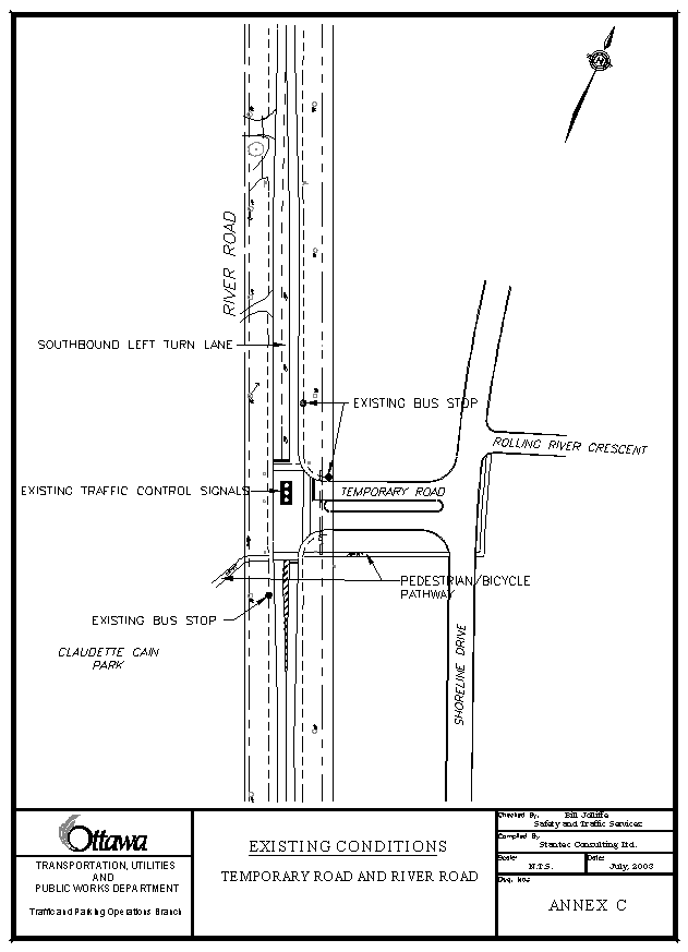
Temporary Road “tees” into the east side of River Road and is equipped
with traffic control signals with pedestrian actuation and audible indication,
as well as street lighting designed to City standards. The lane arrangements on the approaches to
the intersection are:
·
northbound
– one combined through/right turn lane
·
southbound
– one left turn lane and one through lane
·
westbound
– one left turn lane and one right turn lane
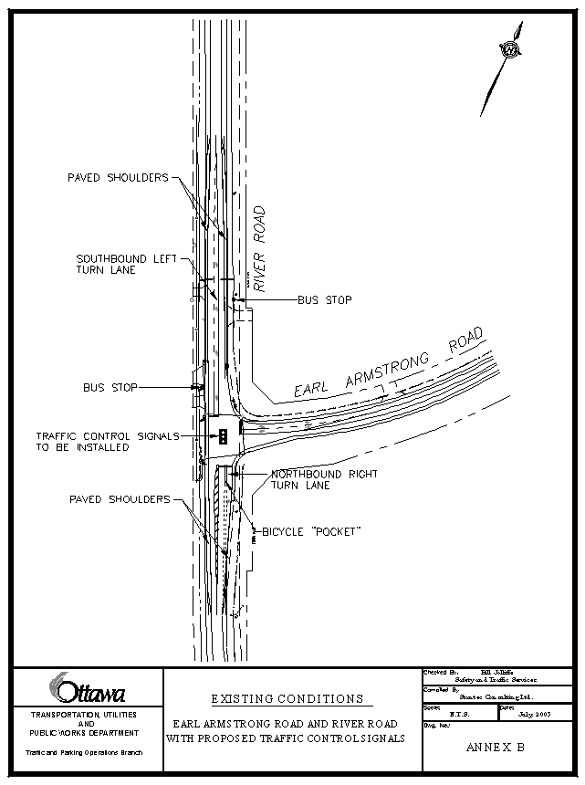
Earl Armstrong Road “tees” into the east side of River Road and is
controlled by a stop sign facing the westbound traffic on Earl Armstrong Road.
It has street lighting designed to City standards. The lane arrangements on the approaches to the intersection
are:
·
northbound
– one right turn lane and one through lane
·
southbound
– one left turn lane and one through lane
·
westbound
– one left turn lane and one right turn lane
Pedestrians
Pedestrian volume counts at the intersection of River Road at Temporary
Road, and, River Road at Earl Armstrong Road recorded 61 pedestrians and 15
pedestrians crossing at these intersections respectively during an 8-hour study
period.
Cyclists
Cyclist volume counts at the intersection of River Road at Temporary
Road, and, River Road at Earl Armstrong Road recorded 20 bicycles and 11
bicycles passing through these intersections respectively during an 8-hour
study period.
River Road, Limebank Road and Earl Armstrong Road are all designated as
“on-road” cycling routes in the draft Transportation Master Plan.
Transit
The RSUC is serviced by OC Transpo Route #196, which enters the
community via the Temporary Road, and by Route #296 that runs on River Road.
Vehicles
|
EXSITING AND FORECAST MOTOR VEHICLE VOLUMES AND
INFORMATION |
||||||
|
Intersection |
Limebank Road and Spratt Road
|
River Road and Temporary Road
|
River Road and Earl Armstrong Road
|
|||
|
Period |
Existing |
Proposed or
Forecasted |
Existing |
Proposed or
Forecasted |
Existing |
Proposed or
Forecasted |
|
Largest Peak Hour Volumes – Northbound Approach |
A.M. 217 |
A.M. 2006 Left – 5 Thru - 250 |
A.M. Right – 18 Thru - 725 |
A.M. 2006 Thru - 1070 |
A.M. Right – 45 Thru - 698 |
A.M. 2006 Right – 52 Thru - 840 |
|
Largest Peak Hour Volumes – Southbound Approach |
P.M. 374 |
P.M. 2006 Right – 1,045 Thru - 195 |
P.M. Left – 282 Thru - 530 |
P.M. 2006 Thru - 770 |
P.M. Left – 15 Thru - 554 |
P.M. 2006 Left – 285 Thru - 485 |
|
Largest Peak Hour Volumes – Eastbound Approach |
N/A |
A.M. 2006 Left – 905 Right - 5 |
N/A |
N/A |
N/A |
N/A |
|
Largest Peak Hour Volumes – Westbound Approach |
N/A |
N/A |
A.M. Right – 421 Left - 57 |
N/A |
A.M. Right – 21 Left - 38 |
A.M. 2006 Right – 230 Left – 44 |
The only roadway designated as a
Truck Route in the RSUC is River Road.
During the past three years, no
collisions were reported at any of the subject intersections.
Annexes B and
C illustrate the current configuration of the intersection of Earl Armstrong
Road and River Road and the intersection of Temporary Road and River Road
respectively.
Design Proposal
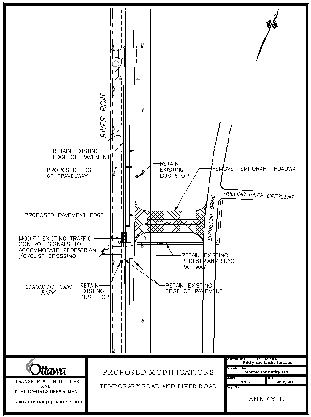
Temporary Road will be closed to vehicle traffic and converted to
building lots. On the south side of the
Temporary Road corridor, the existing pedestrian/cyclist pathway will remain
open. The traffic control signals will
remain in operation to service pedestrian and cyclist movements crossing River
Road to access Claudette Cain Park located between the roadway and the Rideau
River. The southbound left turn lane
will be removed from River Road.
Due to the changes at the intersection of River Road and Temporary Road,
vehicle traffic will be redistributed to the existing intersection of River
Road and Armstrong Road where new traffic control signals will be installed.
It is estimated that in the
future, 75% of the peak hour traffic generated by the community will flow
through the intersection of Spratt Road and Limebank Road and new traffic
control signals will be installed at that intersection. Provision will be made for pedestrian
activation and audible indications.
Annex D depicts the design
of the closed Temporary Road and the resulting proposed modifications to River
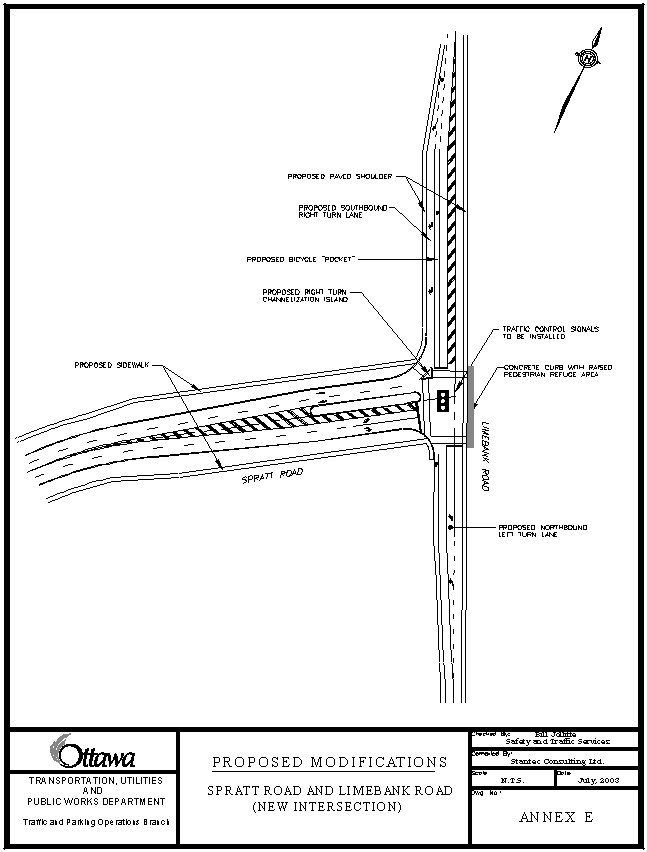
Road. Annex E illustrates the proposed
modifications to Limebank Road at the new intersection with Spratt Road.
No physical changes to the
existing geometry and lane arrangements are proposed at the intersection of
River Road and Earl Armstrong Road. The
existing stop sign facing Earl Armstrong Road will be removed, and the new traffic
control signals will be installed using existing underground ducts previously
installed for this purpose. Provision
will be made for pedestrian activation and audible indications.
Pedestrians
At the intersection of Limebank Road and Spratt Road, there will be 2.0m wide sidewalks on both sides of Spratt Road, and paved shoulders on both sides of Limebank Road, as well as a raised platform area on the east side of Limebank Road.
At the intersection of River Road and former Temporary Road, the
existing paved shoulders on both sides of River Road, and the
pedestrian/cyclist pathway from River Road to Shoreline Drive will be
maintained.
At the intersection of River
Road and Earl Armstrong Road the existing paved shoulders on both sides of both
River Road and Earl Armstrong Road will be maintained.
Cyclists
At the intersection of
Limebank Road and Spratt Road there will be shared use curb lanes on Spratt
Road, and paved shoulders on Limebank Road.
A bicycle “pocket” lane will be located between the southbound right-turn
lane and the through lane.
At the intersection of River Road and
former Temporary Road the existing paved shoulders on both sides of River Road
and the pedestrian/cyclist pathway from River Road to Shoreline Drive will be maintained.
At the intersection of River Road and Earl Armstrong Road, the existing
paved shoulders on both sides of both roadways will be maintained, as well as
the bike “pocket” between the northbound right-turn lane and through lane.
Transit
OC Transpo Route #196 will
be redirected to enter the RSUC via Spratt Road from Earl Armstrong Road, and
exit the community via Spratt Road to Limebank Road. No change is proposed for the Route #296 that travels along River
Road.
Vehicles
The intersection of Limebank
Road and Spratt Road will have the following lane arrangement:
·
Northbound approach, one left-turn lane and one through lane;
·
Southbound approach, one right-turn lane and one through lane; and,
·
Eastbound approach, one left-turn lane and one right-turn lane.
In addition, the new
intersection of Limebank Road and Spratt Road will have street lighting
designed to City standards.
The intersection of River
Road and former Temporary Road will revert to one through lane in the
northbound direction and one through lane in the southbound direction.
No changes will be made to
the lane arrangements at the intersection of River Road and Earl Armstrong
Road.
TRANSPORTATION MASTER PLAN
The guiding principal from the draft Transportation Master Plan (TMP) is
the responsible management of the City’s growth through the encouragement of
walking and cycling, with a strong emphasis on an expanded role for public
transportation. The following proposed
design features support this management principle.
·
Provision
of a 2.0m wide concrete sidewalk along both sides of the extension of Spratt
Road to Limebank Road and the provision of a raised platform/refuge area on the
east side of Limebank Road at the intersection with Spratt Road (Section 4.4.1,
Section 5.1.3, and Section 5.2.4 (a) of the TMP).
·
The
maintenance of the existing pedestrian/bicycle pathway on the Temporary Road
linking River Road with Shoreline Drive and the continued operation of traffic
control signals to assist pedestrians and cyclists crossing River Road (Section
4.4.1, Section 5.3.1 and Section 6.1.7 of the TMP).
·
The
installation of traffic control signals and painted crosswalks at the
intersection of River Road and Limebank Road. (Section 4.4.1, and Section 5.1.3
of the TMP).
·
Provision
of widened paved shoulders on Limebank Road through the Spratt Road intersection,
and provision of a 2.0m wide southbound bicycle “pocket” lane to accommodate
cyclists (Section 6.1.7 of the TMP).
ENVIRONMENTAL
IMPLICATIONS
RURAL IMPLICATIONS
N/A
CONSULTATION
The Ward Councillor is aware
of the recommendations and the community expects the modifications to take
place in accordance with the conditions of the subdivision agreement.
COST ESTIMATES
The initial cost estimate
based on the conceptual design details is $690,000. This amount includes $450,000 for the design and construction of
the intersections and removal of Temporary Road and $240,000 for the
installation of traffic control signals at the intersections of Earl Armstrong
Road/River Road and Limebank Road/Spratt Road, as well as the conversion of the
traffic signals at River Road/Temporary Road to function as pedestrian/cyclist
traffic control signals for the crossing of River Road.
The estimated increase in
annual maintenance costs is $20,000 (traffic control signal maintenance and
energy - $7,000, roadway maintenance - $7,000, and lighting maintenance and
energy - $6,000).
FINANCIAL IMPLICATIONS
Should Council approve the
above noted modifications, the Developer will be responsible for:
·
100% of the cost for the design and construction of the intersection of
Limebank Road and Spratt Road;
·
Removal of Temporary Road,
removal of the southbound left turn lane on River Road at Temporary Road and
traffic control signal modifications at that intersection; and,
· 100% of the operating and maintenance costs for the traffic control signals until warrants are met.
An agreement with the developers provides for the front-ending of the traffic control signal installation costs by the Developers. Subject to Council approval of the 2004 Capital Budget, the proponents are to be reimbursed by the City from development charges or be paid carrying costs at the prime rate of the City of Ottawa’s financial institution until such time the advance is discharged. The City has identified a budget requirement for future traffic control signals in Internal Order #900837 in its five year forecast commencing 2004. Pursuant to the agreement, this request imposes a pre-commitment of the 2004 Capital Budget.
The estimated annual cost to maintain the roadway and street lighting is $13,000, which will be identified in the 2004 Operating Budget.
The City of Ottawa will, as per the legal agreement, retain financial securities until such time as the work is completed to the satisfaction of the City and the City assumes operating costs of the traffic control signals, estimated to occur in 2005.
SUPPORTING DOCUMENTATION
Annex A1 Location Plan - Riverside South Urban
Community
Annex A2 Key Plan – Riverside South Urban
Community Proposed Roadway Modifications
Annex B Existing Conditions – Earl Armstrong
Road and River Road
Annex C Existing Conditions – Temporary Road
and River Road
Annex D Proposed Modifications – Temporary
Road and River Road
Annex E Proposed Modifications – Spratt Road
and Limebank Road (new intersection)
Subject to approval by Council of the recommendations contained in this
report, and on the execution of a legal agreement with the City of Ottawa with
respect to the roadway modifications and funding, to the satisfaction of the
General Manager Transportation, Utilities and Public Works, the developers
intend to commence construction immediately.