Report to/Rapport au:
Transportation and
Transit Committee/
Comate des transports et des
services de transport en commun
and Council/et au Conseil
/
13
August 2003 / le
13 août
2003
Submitted by/Soumis par: R.T. Leclair, General
Manager/Directeur général
Transportation, Utilities
and Public Works/Transport, services et travaux publics
Contact/Personne ressource: Michael J. Flainek, P. Eng.,
Director/Directeur
Traffic and Parking Operations Branch/
Circulation et Stationnement
580-2424, extension 26882, Michael.Flainek@ottawa.ca
|
Ref N°: ACS2003-TUP-TRF-0030 |
SUBJECT: PROPOSED MODIFICATIONS TO THE INTERSECTION OF MERIVALE ROAD AND MACFARLANE ROAD IN RESPONSE TO THE FINDINGS OF THE MERIVALE ROAD – CN RAIL GRADE CROSSING SAFETY ASSESSMENT
OBJECT: MODIFICATIONS PROPOSÉES À
L’INTERSECTION DES CHEMINS
MERIVALE ET MACFARLANE PAR SUITE DES
CONCLUSIONS DE
L’ÉVALUATION DE SÉCURITÉ DU PASSAGE À NIVEAU
DE LA VOIE FERRÉE DU CN SUR LE CHEMIN MERIVALE
REPORT RECOMMENDATIONS
That the Transportation and Transit Committee recommend that Council
approve:
1. the modifications to
MacFarlane Road and Merivale Road, as illustrated in Annex C (McCormick-Rankin
Drawing 5032-500-02) dated August 2003
2. the transfer of funds from the
Railway Crossing Upgrades account ($134,000) to the Intersection Modification
Program account to supplement the funding allocation for the modifications to the intersection of
MacFarlane Road and Merivale Road.
3. the deferral of the intersection
modification proposed at Coventry Road and Vanier Parkway in favour of funding
for the modifications at the intersection of Merivale Raod Road and MacFarlane Road.
RECOMMANDATIONS DU RAPPORT
Que
le Comité des transports et des services de transport en commun recommande au
Conseil municipal d’approuver :
1. les
modifications au chemin MacFarlane et au chemin Merivale, telles qu’elles sont
illustrées à l’annexe C (Dessin 5032-500-02 de McCormick-Rankin) en date d’août
2003.
2. le transfert de fonds du compte des
améliorations de passages à niveau (134 000 $) au compte du programme de
modifications des intersections afin de compléter les fonds alloués à
l’intersection du chemin MacFarlane et du chemin Merivale.
3. le report de la modification
proposée pour l’intersection du chemin Coventry Road et de la promenade Vanier
au profit du financement des modifications à l’intersection du chemin MacFarlane et du chemin Merivale
BACKGROUND AND OVERVIEW
In January 2001, CN Rail officials alerted the Department of their concern for safety at the rail level crossing on Merivale Road immediately north of MacFarlane Road. The alert stemmed from an increase in the frequency of “near miss” occurrences involving high-speed VIA Rail trains and vehicles “stopped on the tracks,” as reported by train operators.
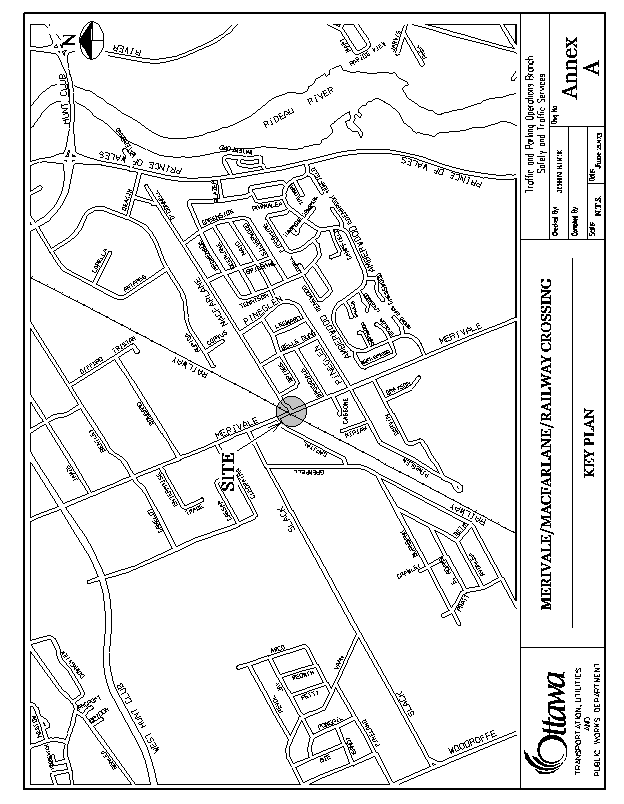
The railway crossing is shown in an area context in Annex A. At this location, Merivale Road is a north-south arterial comprised of one northbound lane and two southbound lanes; one for left turns to MacFarlane Road, the other for through movements. MacFarlane Road is a two-lane collector that “tees” into Merivale Road from the east, immediately south of the rail crossing.
Studies conducted by staff confirmed the problem. In peak periods, southbound left-turning drivers on Merivale Road were frequently delayed awaiting gaps in the opposing northbound flow to enter MacFarlane Road. Vehicle queues quickly formed behind those vehicles that extended beyond the railway tracks.
In February 2001, a media event was launched to raise public awareness. This was followed by rigorous police enforcement and the installation of additional warning signs and pavement markings at the rail crossing. These actions reduced “Do Not Stop on Tracks” violations by 78 to 90%, but they did not eliminate the problem entirely; therefore, the Department continued to seek a safer solution.
The most obvious solution appeared to lie in signalizing the intersection, assuming that the traffic control signal could be interconnected with the railway’s detection system that activates the warning bells and flashing red lights and then lowers the “gates” at the crossing when trains approach. Accordingly, the Department asked rail officials to consider that option.
Railway crossings on roadways represent a critical design element whose development must be undertaken according to strict regulations found in the Canadian Transportation Agency, General Order E-4: “Standard Regulations Respecting the Construction of a Crossing of a Highway and a Railway at Grade”. In support of this regulation, the Rail Safety Directorate of Transport Canada recently published a draft manual (RTD 10) to provide guidance on the construction and maintenance of railway grade crossings. Although in draft form, the Geometric Design Guide for Canadian Roads stresses the need to refer to this document in dealing with railway grade crossing issues, thus incorporating it as de-facto geometric design practice in this country. In addition, Transport Canada has published draft Railway Grade Crossing Safety Assessment Procedures that provide additional technical guidance for the evaluation of such crossings under the RTD 10 directives.
Accordingly, it is now incumbent on road authorities to undertake their own analysis to determine the appropriateness of countermeasures that may be considered in correcting safety issues at rail crossings. Furthermore, part of that evaluation involves the need to accurately assess driver workload and other human factors issues at these crossings. Given those requirements and considering the seriousness of consequences that could arise if the evaluation is not done properly, the Department retained Delphi-MRC to conduct the assessment as that firm has the expertise to do so.
To compound matters, in March of this year, bus operators complained that it is virtually impossible to make southbound left turns onto MacFarlane Road without having some portion of the bus stopped on the tracks. To address that concern, OC Transpo undertook a public consultation to temporarily re-route buses through the adjoining Pineglen Community. Residents of Pineglen Crescent were willing to do their part to solve the problem, but were fearful that their personal safety as pedestrians would be compromised if the bus routes remained on that street during winter months. Pineglen Crescent has no sidewalks and is less than 6m wide, making it difficult for buses to pass one another in opposite directions, even in non-winter months. During the public meeting, a commitment was made by the Ward Councillor to remove the buses from Pineglen Crescent within six months, by which time it was hoped that the Merivale/MacFarlane intersection would be signalized.
In late June 2003, the consultant’s report entitled “Merivale Road – CN Rail Grade Crossing Safety Assessment” was received from Delphi-MRC. In discussing their analysis with staff, it has been determined that signalization will not correct the problem. In fact, given the geometry of this intersection and the types of vehicles that use it, the installation of traffic control signals at the intersection in its current configuration, might worsen the situation. A copy of the report has been provided to and discussed with the Ward Councillor and another is on file in the Office of Secretariat Services.
The only remaining option is to physically move the MacFarlane Road
intersection further south, thereby increasing the distance between it and the
rail crossing. This will require the
realignment of the westerly portion of MacFarlane Road so that it then
intersects with Merivale Road at a point approximately 80m south of its current
location. A vacant parcel of land owned
by the City is available for this purpose.
In this way, the southbound left-turning lane can be extended to provide
storage for approximately 13 vehicles during peak periods.
The Ward Councillor agreed with this option and a Public Open House was held at St. Monica’s Catholic School on 24 July 2003. Over 100 local residents and business owners that attended supported a phased approach to implementing this option. Initially, southbound left turns are to be prohibited on Merivale Road at MacFarlane Road for the weekday peak periods (7:00 – 9:00 a.m., 3:30 – 5:30 p.m., Monday to Friday). When construction of this realignment is completed – in the late Fall, the existing westerly end of MacFarlane Road will be closed just east of Merivale Road and all peak period turn restrictions will be rescinded and OC Transpo buses will be re-routed from the Pineglen Community back on to the re-aligned MacFarlane Road.
The Ward Councilor
agreed with this option. An Open House was held at St. Monica’s School on
24 July 2003. The realignment option and its
supporting initiatives were presented and
overwhelmingly supported by
those residents and business owners in attendance. The overall
proposal as
put forth by staff is as follows:
That southbound left turns be prohibited at the
intersection of Merivale Road and MacFarlane Road as quickly as possible during
weekday peak periods from 7:00 to 9:00 AM and 3:30 to 5:30 PM (Mon –Fri).
Note: This
turn restriction was implemented on Thursday, 13 August 2003. Prior to its implementation, flyers were
distributed to drivers on August 11th and 12th, informing
them of the safety issue at the rail crossing and asking for their cooperation
by altering their travel patterns to use West Hunt Club Road and Prince of
Wales Drive. The restriction affects
approximately 250 vehicles each morning and 400 each afternoon.
1.That adjacent
intersections along Merivale Road; specifically, at Brookdale Avenue, Pineglen
Crescent and Amberwood Crescent be monitored and if necessary, signs also be
erected at those sites to prohibit southbound left turns during weekday peak
periods, to deter short-cutting through the Pineglen and Country Place
communities.
1.That the
westerly portion of MacFarlane Road be realigned to intersect with Merivale
Road at a point south of its current location, directly opposite the northerly
access to St. Monica’s Catholic School.
1.That during
the construction of the realignment, underground cable ducts be installed
across Merivale Road to facilitate the installation of a pedestrian signal, if
surveys to be conducted in September after school commences show that
conditions meet or are approaching those that warrant the installation of that
device.
That when construction of the realignment is
complete, the existing westerly end of MacFarlane Road be closed just east of
Merivale Road, all peak period turn restrictions be rescinded and all OC
Transpo buses be re-routed from the Pineglen Community back onto the realigned
MacFarlane Road.
To
expedite the foregoing, Delphi-MRC has also been retained to complete the
detailed design for this roadway modification and to prepare the necessary
construction specifications and tender documents.
The intent of this report is to identify the seriousness of this safety issue and obtain Council approval to proceed with this work as quickly as possible, so that the new alignment of MacFarlane can be constructed and become operational before winter (target date is mid November).
DISCUSSION
As previously noted, Merivale Road at this rail crossing is a north-south arterial comprised of one northbound lane and two southbound lanes; one for left turns onto MacFarlane Road, the other for southbound through movements. MacFarlane Road is a two-lane collector that “tees” into Merivale Road from the east, immediately south of the crossing.
Studies conducted by staff of the Safety and Traffic Services Division confirm that in peak periods, southbound left-turning drivers intent on entering MacFarlane Road are often delayed awaiting gaps in the northbound flow. Queues quickly form that extend beyond the tracks.
Moreover, with no upstream traffic control signal to “platoon” the northbound flow arriving at the intersection, southbound left-turning gaps are of random arrival and duration. This gives rise to situations where two left-turning drivers are occasionally able to use the same gap; however, to take advantage of such opportunities, the second vehicle must be stationed as close as possible to the lead vehicle. This, in essence, “invites” or encourages drivers of trailing vehicles to stop on the tracks where they are often delayed for extended periods, some well in excess of a minute.
Field studies show that the average operating speeds for eastbound and westbound passenger trains are 68 mph (109 km/h) and 47 mph (76 km/h), respectively. These speeds are well within the maximum permissible operating speed of 95 mph (153 km/h) for passenger trains using this line; nonetheless, they do not provide drivers stopped on the tracks, or very close to them, with much time to clear the area when a train is approaching. In fact, depending on the exact speed of the train, those drivers only have about 30 seconds to do so after the warning bells and flashing red lights are activated.
A similar concern is created by the proximity of the entranceway to Eastway Tank, Pump and Meter Limited. That access is also located on the east side of Merivale Road immediately north of the grade crossing; therefore, southbound tanker trucks entering that facility must also negotiate left turns across the northbound flows. This gives rise to situations where a “good Samaritan” heading north will stop just north of the tracks and signal the tanker truck to cross the northbound lane. Considerable time is required for those trucks to accelerate from a complete stop and to fully negotiate that left turn, especially if the tanker is pulling a “pup” trailer. Those delays create northbound queues across the tracks.
In a perfect world, drivers would never stop on the tracks and if for some reason they did, all drivers would be reliable enough to quickly respond to clear the tracks. However, that is not the case. Drivers rely on their judgment and decision-making skills, but no one is infallible – as drivers, we all make mistakes. Furthermore, all that’s required to cause a disaster at this site is for one vehicle to stall, whether directly on the tracks or even close to them. Should that occur, a vehicle stopped on the tracks might not be able to move past the stalled vehicle, out of harm’s way.
For these reasons, The Geometric Design Guide for Canadian Highways notes:
Close proximity of road intersections and road
crossings of railways compound the judgment and decision making requirements
for motorists, thereby increasing the risk for error.
And, the RTD 10 Technical Requirements point out:
When an unrestricted grade crossing, or a road intersection, or a property access on the road approach to an unrestricted grade crossing is to be constructed, the location shall be such that no part of the traveled way of the intersection, road or entranceway, or stop line or position for a traffic control device, shall be closer than 30m to the nearest rail of the grade crossing, where the maximum railway operating speed exceeds 15 miles per hour.
At this grade crossing, both MacFarlane Road and the entranceway to Eastway Tank, Pump and Meter Limited are within the 30m crossing approach envelopes; therefore, neither conforms to the RTD 10 requirement.
In terms of risk, it is also difficult to quantify absolute thresholds, above which some prescribed action must be taken. For example, the most commonly used warrant considered for grade separating a railway from the roadway is “the cross product rule”. This “exposure” benchmark indicates that when the product of the AADT traffic volumes times the number of trains per day reaches 200,000, consideration of a grade separation should be taken.
It is important to note that the benchmark is not meant to be taken as a justification for the grade separation, but as a signal that consideration should be given to undertaking the necessary detailed work to assess this need. The recognition that detailed engineering studies are required as the basis for reaching a decision on whether or not a grade separation can be recommended is virtually universal in the relevant North American technical literature.
At this grade crossing, the 2001 traffic count yielded an AADT of just over 17,200 and in 2002, this rose to approximately 18,200. The Merivale crossing is currently utilized by 10 VIA Rail passenger trains each day and two freight trains operated by OCR. However, a number of new initiatives presently being considered by VIA Rail suggest that this volume may substantially increase. Plans for two additional round trips between Ottawa and Toronto will raise the number of passenger trains using the grade crossing to 14 in the near future for a total train volume of 16 per day. VIA is also examining the possibility of extending three of its Ottawa-Montreal trips to the Barrhaven Station. These combined initiatives could result in a total of 22 train crossings per day in the near future.
In summary then, the current AADT (18,200) multiplied by the train crossing volume (12) yields a cross product in excess of 200,000. Considering that vehicle-volumes and train crossings per day will only increase with the on-going development of Nepean South and the initiatives planned by VIA Rail, it is now imperative that this crossing be monitored regularly and that all possible steps be taken to address public safety issues in a timely manner at this crossing.
In their report, entitled “Merivale Road – CN Rail Grade Crossing Safety Assessment” Delphi-MRC stressed that the intent of grade crossing safety assessments is to proactively evaluate the safety performance of the crossing in a manner that is in keeping with the process that is used consistently for this purpose across the country. This results in a safety review that is somewhat more rigid and prescriptive than that of the traditional road safety audit process, but which is essential in the context of both the technical and the regulatory environments within which such assessments are executed. Through this review, it became clear that signalizing the Merivale/MacFarlane intersection is not an option. Other key findings of the report are:
· This railway crossing represents an area of very high driver workload and elevated risk. Multiple factors conspire to raise the level of risk, including deficiencies in sight distance and other crossing requirements, poor levels of service, the need to accommodate large trucks in the traffic stream, inadequate treatment of vulnerable road users, and a number of other elements. Early and specific actions should be considered in the immediate and near-term futures.
· The current condition of the crossing underscores the need for prudence in its redevelopment, as well as the need for early action and longer term planning and development measures that recognize and deal with a complex road safety situation.
· As one possible measure for near term action, early consideration should be given to the possible relocation of MacFarlane Road outside the minimum 30m crossing approach envelope.
· Another possible measure for near term action is that early consideration should be given to closure of the tank farm access driveway and its replacement with an access outside the 30m crossing envelope.
· Longer-term actions should strive to preserve the flexibility to move to a grade separated crossing in this area in the future.
In view of the need to consider early and specific actions in the immediate and near term futures, staff has requested Delphi-MRC to provide a strategy for implementing progressive countermeasures to cope with increasing “exposure” when specific “trigger points” are reached. In this way, the City will be able to better plan for future actions, including grade separation, at this site.
It should also be noted that staff are currently considering alternatives to provide alternate access to the property owned by Eastway Tank, Pump and Meter Limited.
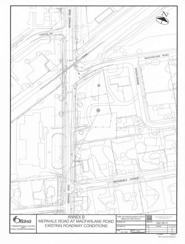
EXISTING CONDITIONS
The existing geometry of the
intersection of Merivale Road at MacFarlane Road is shown in Annex B.
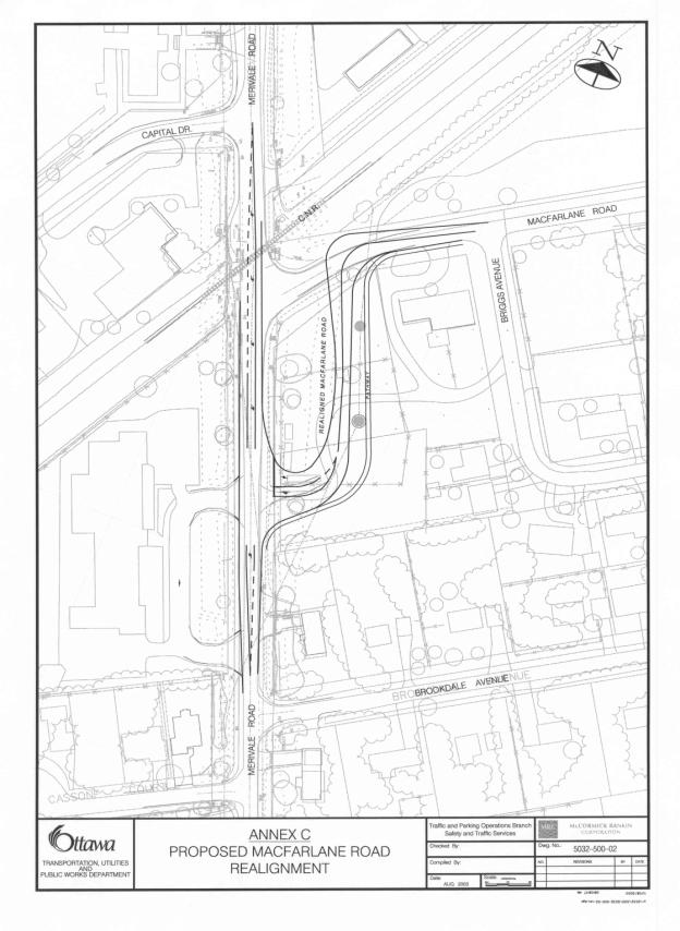
DESIGN PROPOSAL
Annex C illustrates the proposed realignment of the
westerly portion of MacFarlane Road, and the roadway modifications to Merivale
Road. The intent of the modifications
is to provide the same level of service to all road users as currently
exists. On that basis:
1. The realigned portion of MacFarlane Road will remain
as a two lane cross-section. A pathway
will be added along the realignment between Merivale Road and Briggs Avenue.
2. Merivale Road in this area will remain, as it now
exists. It has a curb and abutting
sidewalk on the west side and a graveled shoulder and ditch drainage on the east
side.
3. Streetlighting will be provided along the realigned
portion of MacFarlane Road and at the new intersection formed by Merivale Road
and the realigned portion of MacFarlane Road.
Streetlight is currently in place along the east side of Merivale Road
in this area.
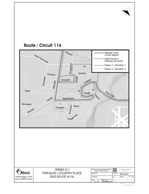
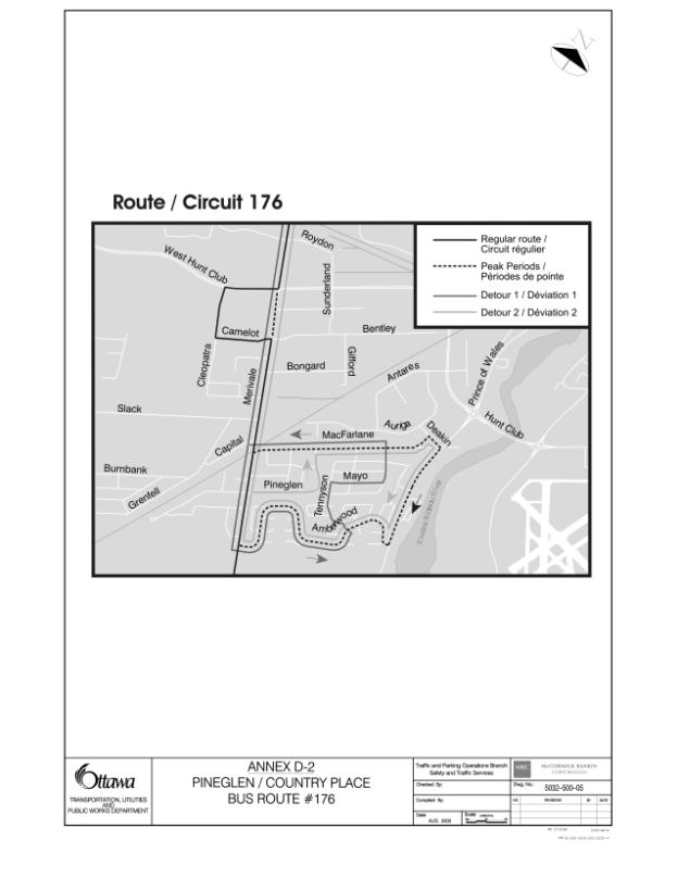
Annexes D1 and D2 illustrate the road network in the immediate area and show bus routes, including the temporary bus routes through the Pineglen Community, implemented in April 2003 and revised in May 2003.
ENVIRONMENTAL IMPLICATIONS
N/A
RURAL IMPLICATIONS
N/A
CONSULTATION
A Public Open House was held at St. Monica’s Catholic School on Thursday, 24 July 2003. It was advertised in Nepean Today and flyers were distributed to all residents and businesses in the Pineglen and Country Place Communities. It was attended by over 100 local residents and business owners that overwhelmingly supported the proposal presented by staff and discussed in this report.
The Ward Councillor has been consulted and is in agreement with the recommendation.
A notice of the proposed modifications has been placed in Le Droit and the Ottawa Citizen for two consecutive weeks.
TRANSPORTATION MASTER PLAN
A guiding principle from the Transportation Master Plan is responsible road design and right-of-way protection. The following proposed feature supports this road design principle.
· The realigned portion of MacFarlane Road expresses the general values and preferences of City residents including those related to safety, mobility and esthetics (Section 9.3.1 of the TMP).
A second guiding principle from
the Transportation Master Plan is transportation system management. Initiatives in pursuit of that goal also
consider road safety objectives. The
following proposed design feature supports this transportation system
management principle:
· The realigned portion of MacFarlane Road will address the immediate public safety concern at the rail crossing and initiate a road corridor that can be extended further south in the future, when a grade separation is required at the CN Rail crossing (Sections 9.5.1A and 9.3.4d).
And finally, a third guiding principle is that in managing its transportation system, the City gives high priority to public safety. The following proposed features support this public safety principle:
· The realigned portion of MacFarlane Road and the extension of the southbound left-turning lane on Merivale Road have been designed as a direct result of the engineering-based Rail Safety Crossing Program. Moreover, the media event and distributions of flyers have helped to raise public awareness and understanding of safe travel behaviours (Sections 9.4.3 and 9.4.4 respectively).
COST ESTIMATES
The initial estimate to realign MacFarlane Road and to modify Merivale Road to accommodate the new intersection is $550,000. The estimated increase in annual operating and maintenance costs is $4,300 (roadway and pathway $3,800, streetlighting $500).
FINANCIAL STATEMENT
The total estimated cost of the design and construction for this roadway modification is $550,000. Funds in the amount of $134,000 are available for transfer from the Railway Crossing Upgrades account, Internal Order number 901180 to the Intersection Modification Program, Internal Order number 900441.
The remaining funds will come from the Intersection
Modification Program. This will require
Council approval to defer the intersection modification,
previously approved by Council for
Vanier Parkway and Coventry Road, and to approve the use
of $416,000 from that project to
assist with the modifications required. The Vanier / Coventry
intersection will be re-priorized
wwithin
next year’s program.
Councillor Legendre has acknowledged the need to defer the Vanier Parkway project and
concurs with the redistribution of the funds to the MacFarlane Road realignment project.
901180 900441
Railway Intersection
Crossing Modification
Upgrades Program
Budget Authority $307,000 $4,808,000
Budget Transfer (134,000) 134,000
Revised Authority 173,000 4,942,000
Total Paid and Committed ( 74,665) ( 3,188,282)
Funds Available 98,335 1,753,718
THIS REQUEST 0 (
550,000)
Balance $ 98,335 $ 1,203,718
The estimated annual cost of maintaining the new portion of the road is $3,800 and the additional costs for street lighting is $500, for total operating costs of $4,300 which will be identified in the 2004 Operating Budget.
ATTACHMENTS
Annex A - Key Plan
Annex B - Existing Roadway Conditions
Annex C - Proposed MacFarlane Road Realignment
Annex D-1 - Pineglen/Country Place Bus Route #116
Annex D-2 - Pineglen/Country Place Bus Route #176
DISPOSITION
Following Council approval, the detailed design of
these roadway modifications and the preparation of contract specifications and
tender documents will be completed by Delphi-MRC by 2 September 2003. The call for tenders will be completed by 22
September 2003 and construction will be completed before winter (target date is
mid November).
ANNEX A