Report
to/Rapport au:
Transportation and Transit
Committee/
Comité des transports et des services de
transport en commun
and Council/et au Conseil
2 June 2003 / le 2 juin 2003
Submitted by/Soumis par: R.T.
Leclair, General Manager / Directrice générale
Transportation, Utilities and Public
Works/Transport, services et travaux publics
Contact/Personne ressource: Michael J. Flainek, P. Eng.,
Director/Directeur
Traffic and Parking Operations Branch/
Circulation et Stationnement
580-2424, extension 26882,
Michael.Flainek@ottawa.ca
|
|
|
Ref N°: ACS2003-TUP-TRF-0018 |
SUBJECT: MODIFICATIONS AT THE INTERSECTION OF
GREENBANK ROAD AND WESSEX ROAD/BERRIGAN DRIVE
OBJET : MODIFICATIONS À L’INTERSECTION DES
CHEMINS GREENBANK ET WESSEX ET DE LA PROMENADE BERRIGAN
REPORT RECOMMENDATION
That the
Transportation and Transit Committee recommend Council approve the proposed
modifications at the intersection of Greenbank Road and Wessex Road/Berrigan
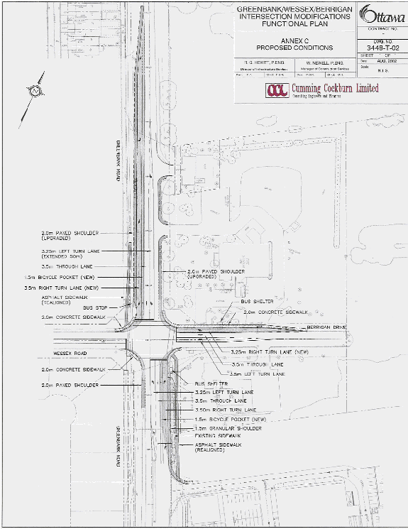
Drive as shown in Annex C (Cumming Cockburn Limited Drawing 3448-T-02).
RECOMMANDATION DU RAPPORT
Que le
Comité des transports et des services de transport en commun recommande au
Conseil municipal d’approuver les modifications proposées à l’intersection des
chemins Greenbank et Wessex et de la promenade Berrigan telles qu’elles sont
indiquées à l’annexe C (dessin 3448-T-02 de Cumming Cockburn Limited).
BACKGROUND
The intersection of Greenbank Road at Wessex Road/Berrigan Drive is located in the Barrhaven area between Fallowfield Road and Strandherd Drive (Annex A refers). Significant commercial and residential growth has occurred in this area during the past few years and as a result, the increased traffic levels now exceed the capacity of this intersection. The intersection performs poorly during peak periods and experiences lengthy delays in servicing northbound, southbound and westbound flows.
Of greatest concern is the safety hazards posed by southbound vehicles queued on Greenbank Road. An at-grade VIA rail crossing is situated approximately 500m north of the intersection and traffic queues frequently extend beyond that point. The rail line carries high-speed passenger trains and despite the presence of warning signs and pavemenet markings to discourage drivers from stopping on the track, vehicles still get stranded at that point from the stop-and-go movement of the queue. In addition, efforts to “meter” southbound traffic by limiting the “green time” at the upstream traffic signal at Foxfield Drive/Malvern Drive, are becoming less effective as turning volumes at that intersection continue to increase. In summary then, to reduce delays at the Greenbank Road and Wessex Road/Berrigan Drive intersection and more importantly, to address safety concerns at the railway crossing, roadway modifications are required.
On 8 January 2003, as part of the City’s 2003 Capital Budget deliberations, Council approved funds within the Intersection Modification Program to implement the modifications required at this intersection.
This report summarizes the preliminary design and public consultation process followed in determining the proposed intersection modifications.
ANALYSIS
Existing Conditions
The study area extends from the CN Railway crossing on Greenbank Road southerly through the intersection with Wessex Road/Berrigan Drive for approximately 600m (refer to Key Plan, Annex A).
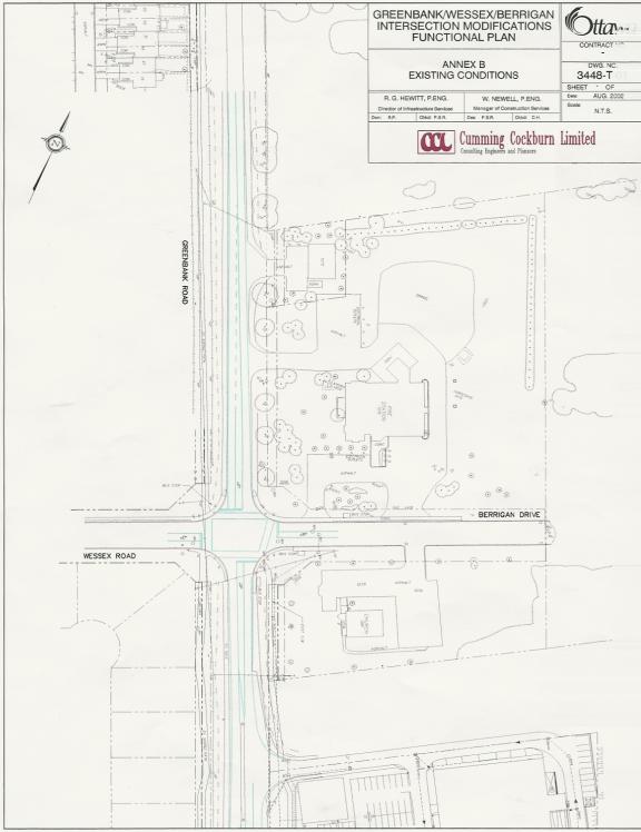
Greenbank Road is a north-south arterial road with a two-lane rural cross-section and posted speed of 60 km/h. It is part of the designated cycling network as identified in the Transportation Master Plan. The intersection is currently signalized (refer to Annex B, Existing Conditions Plan, Cumming Cockburn Limited Drawing 3448-T-01). The existing intersection configuration is comprised of the following:
· The southbound approach to the intersection (Greenbank Road) consists of a 3.3m wide combined through and right-turn lane and a 45.0m long, 3.0m wide left-turn lane. There is a 1.5m wide asphalt path on the west side of the road.
· The northbound approach to the intersection (Greenbank Road) consists of a 3.3m wide combined through and right-turn lane and a 40m long, 3.0m wide left-turn lane. There is a 3.0m wide recreation path on the west side and a 2.0m wide sidewalk on the east side of the road.
· The westbound approach to the intersection (Berrigan Drive) consists of a 4.0m wide combined through and right-turn lane, a 3.0m wide left-turn lane and 2.0m wide sidewalks on both sides of the road.
· The eastbound approach to the intersection (Wessex Road) consists of a 3.8m wide combined through and right-turn lane, a 3.0m wide left-turn lane and a 2.0m wide sidewalk on the north side of the road.
Pedestrians
Pedestrian facilities on the west side of Greenbank Road consist of an asphalt path north of the intersection and a recreation path south of the intersection. An asphalt sidewalk is present on the east side of Greenbank Road, south of the intersection and a mix of concrete and asphalt sidewalks are located at the intersection. The count conducted on Monday, 16 September 2002 indicated that 119 pedestrians crossed Greenbank Road and 86 pedestrians crossed Wessex Road/Berrigan Drive, during the eight-hour survey period.
Cyclists
Presently there are no dedicated cycling lanes or wider shared-use curb lanes present on Greenbank Road or at the intersection. There is a recreational path on the west side of Greenbank Road, south of the intersection that is used by cyclists. The count done in September 2002 showed that during the eight-hour survey period, 13 cyclists crossed the north leg of Greenbank Road and 16 cyclists crossed the south leg. Further, 15 cyclists crossed Wessex Road and 13 cyclists crossed Berrigan Drive.
Transit
The existing transit routes on Greenbank Road are Local Route 170, Peak Period Route 181 and Peak Period Express Route 73. Bus stops are situated on the approaches to the intersection on both sides of Greenbank Road and on Berrigan Drive. In addition, there are bus stops on Wessex Road approximately 45m from the intersection.
Emergency Services
Ambulance and fire services are
housed in a fire station on Berrigan Drive immediately east of Greenbank
Road. The traffic control signal at the
Greenbank Road at Wessex Road/Berrigan Drive intersection is equipped with pre-emption technology that enables
those emergency service providers to enter the intersection on a priority
basis, after egressing their site on Berrigan Drive.
Automobiles
The eight-hour turning movement count conducted on Monday, 16 September 2002 showed intersection approach volumes on Greenbank Road of 5,100 vehicles northbound and 5,500 vehicles southbound. In the a.m. peak hour, approach volumes on Greenbank Road were 560 vehicles northbound and 460 vehicles southbound and in the p.m. peak hour, approach volumes were 1,000 northbound and 1,200 southbound.
The count also showed that on Wessex Road, the intersection approach volumes were 430 vehicles in the a.m. peak hour and 230 vehicles in the p.m. peak hour while on Berrigan Drive, the approach volume counts were slightly higher with 490 vehicles in the a.m. peak hour and 310 vehicles in the p.m. peak hour.
Collisions
During the three-year period ending 31 December 2002, 23 collisions were reported at the intersection of Greenbank Road/Wessex Road/Berrigan Drive. Two involved cyclists, none involved pedestrians. The most frequent collisions (10 of the 23 or 43%) were rear-end types occurring on the congested southbound approach.
DISCUSSION
In early 2002, the City initiated the South Nepean Traffic Operational Review, to review the planned development of the South Urban Community and its implications on the road system capacity. The review’s final report, by Delcan Corporation, was delivered in July 2002, and identified the operational improvements for the planned short-term development (2001 to 2007) in the study area. As specific capacity improvements were not identified in the original report, Delcan was subsequently requested by the City to propose alternative, interim improvements.
This subsequent review identified widening of Greenbank Road to four-lanes through the Wessex Road/Berrigan Drive intersection by the year 2007, to coincide with the road-rail grade-separation works. In the interim, lower-cost modifications were recommended to achieve an acceptable level of service (volume to capacity ratio (v/c) less than 0.9) and reduce the southbound queuing. The intersection currently operates at an overall level of service LOS E (v/c) = 0.96) in the p.m. peak hour. With this poor level of service, queues develop in the southbound direction that cannot be serviced with each cycle of the traffic control signal.
A comparison of traffic counts taken in May 2001 and May 2002, indicates a vehicle volume growth rate exceeding 12% in the p.m. peak hour for the critical southbound direction (980 vph to 1,100 vph). A follow-up count conducted on 16 September 2002 showed that this volume increased a further 9% in the southbound direction, reaching a p.m. peak hour volume of 1,200 vph.
Design
Proposal
Based on the foregoing, the following modifications are proposed for the Greenbank Road/Wessex Road/Berrigan Drive intersection:
·
the addition of a 180 m long southbound
right-turn lane;
·
an extension of the southbound left-turn lane
from 45m to 90m;
·
the addition of a westbound right-turn lane
which will extend beyond the access to the fire station;
·
the addition of a 100m northbound right-turn
lane; and,
·
changes to the traffic control signal phasing to
provide a northbound left-turn phase, in addition to the existing southbound
left-turn phase.
Based on these proposals, a functional
plan was developed which forms the basis of the recommendations of this report
(refer to the Proposed Conditions Plan, Annex C, Cumming Cockburn Limited
Drawing 3448-T-02).
These modifications are projected to support
the forecasted volumes for the year 2005/2006.
The Environmental Assessment for Greenbank Road (West Hunt Club to
Strandherd Drive) scheduled to begin within the next 12 months, will identify
future infrastructure needs and timing to ensure safe conditions along
Greenbank Road in the longer term.
Design
Features
The existing pedestrian facilities will be enhanced with the provision of standard 2.0m wide concrete sidewalks at the intersection.
A southbound 1.5m wide cycling pocket will be provided between the southbound right-turn lane and the southbound through lane to facilitate cycling movements through the intersection. Similarly in the northbound direction, a 1.5m pocket will be provided between the northbound right-turn lane and the northbound through lane.
In consultation with OC Transpo, bus stops will be maintained at the existing locations on Greenbank Road, Berrigan Drive and Wessex Road.
ENVIRONMENTAL
IMPLICATIONS
N/A
RURAL IMPLICATIONS
N/A
CONSULTATION
The proposed intersection modifications fall under Schedule “A” of the Class Environmental Assessment for Municipal Road Projects. A notice of the proposed roadway modifications was placed in Le Droit and the Ottawa Citizen for four consecutive weeks starting 14 August 2002. No formal complaints were received in response to the public notice.
Cycling facilities are consistent with the City’s cycling design standards as required on designated cycling routes.
The Ward Councillor has been circulated and is in agreement with the recommended design. In addition, temporary signs have been placed at the intersection informing the public that roadway modifications are proposed. The signs display a telephone number at which comments and concerns can be left and from which additional information can be obtained, should callers wish to discuss the matter with staff.
TRANSPORTATION
MASTER PLAN
A guiding principle of the Transportation Master Plan (TMP) is the provision of a modal hierarchy with emphasis on walking, cycling and transit use. This principle is reflected in the following features of the proposed intersection modifications:
· The provision of concrete sidewalks at the intersection will provide a connection between shared use paths, provide transit users with a safe and convenient access to bus stops and provide a refuge area for pedestrians prior to crossing the road. This conforms to section 2.4.1 Item 8 and Section 2.2.3 respectively of the TMP.
· The provision of a 1.5m cycling pockets along the parallel sections of the northbound and southbound right-turn lanes conforms to section 2.3.2, Item 3 of the TMP.
· The upgrading of the paved shoulders to facilitate cyclists along the east and west side of Greenbank Road north of the intersection and the west side of Greenbank Road south of the intersection conforms to section 2.3.2, Item 3 of the TMP.
In addressing the overall roadway efficiency and safety intent of the TMP, the improvement in the Level of Service at the Greenbank Road/Wessex/Berrigan intersection and reduction of queuing lengths, through the provision of turning lanes and extension of existing turning lanes, conforms to Section 1.1 of the TMP.
FINANCIAL IMPLICATIONS
The total estimated cost for the design, property acquisition, construction inspection, traffic signal control, street lighting and roadway modifications is estimated at $684,500.00 (including GST). Funds are available in 2003 Capital Budget, Order Number 900441, Intersection Modification Program.
Construction Costs $486,650.00
Engineering (Detailed Design & Construction Inspection) $ 81,300.00
$567,950.00
GST $ 39,756.00
$607,706.00
Property (Estimate) $ 20,000.00
$627,706.00
Contingency $ 56,794.00
TOTAL $684,500.00
DISPOSITION
Subject to Council approval of the recommendations contained in this report, staff will:
· Undertake final detailed design;
· Provide project management services;
· Tender the required road works; and,
· Arrange for construction to begin in the late summer of 2003 to be completed by Fall 2003.
Annex A Greenbank/Wessex/Berrigan
Modifications – Key Plan
Annex B Greenbank/Wessex/Berrigan
Intersection Modifications –
Existing Conditions
Annex C Greenbank/Wessex/Berrigan Intersection Modifications –
Proposed Conditions
ANNEX A
Greenbank/Wessex/Berrigan Modifications – Key Plan
ANNEX B
Greenbank/Wessex/Berrigan
Intersection Modifications –
Existing Conditions
ANNEX C
Greenbank/Wessex/Berrigan Intersection Modifications –
Proposed Conditions