Report to/Rapport au :
Transportation and Transit Committee/
Comité des transports et des services de
transport en commun
and Council/et au Conseil
March 28, 2003/le 28 mars 2003
Submitted by/Soumis par: R.T.
Leclair, General Manager/Directrice générale,
Transportation,
Utilities and Public Works/Transports, Services et Travaux publics
Contact/Personne-ressource: G.
Diamond, Director/Directeur,
Transit Services/Services de transport en commun
842-3636 ext./poste 2271,
gordon.diamond@transpo.ottawa.on.ca
|
|
Ref N°: ACS2003-TUP-TRN-0004 |
SUBJECT: OC TRANSPO TRANSPLAN 2003
OBJET : TRANSPLAN
2003 D’OC TRANSPO
REPORT RECOMMENDATION(S)
That
the Transportation and Transit Committee recommend Council approve the
following changes to the OC Transpo route network, to extend and introduce
transit at the new Terry Fox Transitway Station and park and ride lot,
introduce service into new residential areas, and to reduce customers’ travel
time, walking distance to the nearest bus stop, or the number of transfers they
need to make:
Area
|
Routes
|
Service
change
|
Kanata
|
Route
68
Routes
97, 118, 160, 161, 162 New express route |
Revised
route
Revised
route to Terry Fox Station
New route from Terry Fox Station |
South
Nepean
|
Route
71
Route 77
Route 119
Routes 170, 173, 176, 186
Routes 116, 176, 185 |
New
route
Revision and extension New east-west service Revised routes Revised routes |
Central
Ottawa
|
Route 82 |
Revised route at Tunney’s Pasture
|
Ottawa
South
|
Route
196
Route 197
|
Revised
route
Revised route
|
Orléans
|
Route 22
Route 136 |
New
route
Re-route and extend |
RECOMMANDATIONS DU RAPPORT
Que le Comité des transports et des services de
transport en commun recommande au Conseil d’approuver les modifications
suivantes aux circuits d’OC Transpo en vue de prolonger le service de transport
en commun jusqu’à la nouvelle station et le nouveau parc-o-bus Terry Fox, de
desservir de nouveaux secteurs résidentiels et de réduire le temps des
déplacements des usagers, la distance de marche jusqu’à l’arrêt d’autobus le plus
près et le nombre de correspondances requises pour arriver à destination :
Secteur
|
Circuit
|
Modification
|
Kanata
|
Circuit 68
Circuits
97, 118, 160, 161, 162 Nouveau circuit
express |
Circuit modifié
Circuit modifié vers la station Terry Fox
Nouveau circuit
depuis la station Terry Fox |
Nepean-Sud
|
Circuit 71
Circuit 77
Circuit 119
Circuits 170, 173, 176, 186
Circuits
116, 176, 185 |
Nouveau circuit
Modification et
prolongement Nouveau service
est-ouest Circuits modifiés Circuits modifiés |
Ottawa-Centre
|
Circuit 82 |
Circuit modifié au pré Tunney
|
Ottawa-Sud
|
Circuit 196
Circuit 197
|
Circuit modifié
Circuit modifié
|
Orléans
|
Circuit 22
Circuit 136 |
Nouveau circuit
Nouveau tracé et
prolongement |
BACKGROUND
Transplan is an annual consultation process through which proposals for the improvement of the transit network are developed, evaluated, introduced, and reviewed in a consistent way. Transplan 2003 started in the fall of 2002, with the development of proposals based on suggestions from transit customers, councillors, and employees. Consultation on these proposals took place in February and March 2003, and the proposals have been improved based on the comments that were received. The recommendations in this report are for service changes to be introduced in September 2003, or later, when new roads and the new Terry Fox Transitway Station are ready.
Transit ridership in Ottawa continues to grow. In 2002, the system wide ridership was 87 million passenger trips, 2.4% higher than it was in 2001. This continuing ridership growth has been aided by the strong commitment of the City government to support and promote transit as a preferred mode of travel. Therefore, it is important that the OC Transpo route network continue to evolve, to best meet customers’ changing and growing travel needs.
Several important improvements were made to Ottawa’s transit system in 2002. Service to the villages and rural areas of the City was improved, with new commuter routes to downtown from many villages, and new all-day service to the largest villages. (A review of the new rural service is the subject of a separate report.) A new connecting bus route was introduced from the north end of the O-Train to the major employment area in the Hull sector of Gatineau. New direct service to downtown was introduced from the Trim park and ride lot in Orléans.
The recommended service changes for 2003 focus on the extension of service into new residential areas, the revision of bus routes to serve the new Terry Fox Transitway Station and park and ride lot, and the continuous improvement of service for customers by making services more convenient and more direct. Transit Services staff are also continuing to make service changes to meet the changing needs of customers on the rest of the route network, by adjusting the frequency of service and the hours of service to ensure that customers are accommodated more comfortably and more efficiently.
A comprehensive programme of consultation was undertaken to gather feedback on the Transplan 2003 proposals from the public and from frontline transit employees. Approximately 200 people attended four open houses and approximately 440 written comments were received. A more comprehensive overview of the process is included in the consultation section of this paper. The comments are described briefly in the discussion of each recommended service change and are available on request from the Clerk’s office.
DISCUSSION
KANATA
The recommended service changes for Kanata would re-route local and Transitway service to the new Terry Fox Station, introduce a new peak period route for customers using the two west end park and ride lots at Terry Fox and at Eagleson, and improve peak period express service for customers in the Kanata Lakes area.
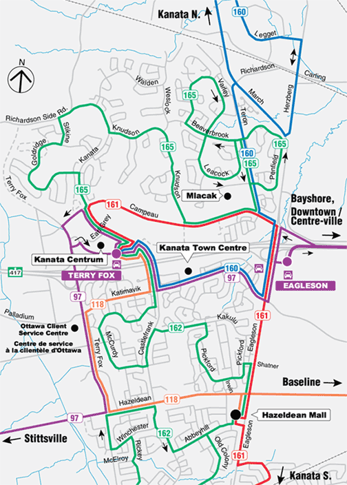
Terry Fox Station –
Revisions to Routes 97, 118, 160, 161, and 162 (Exhibit 1)
It is recommended that the
following route changes be made when Terry Fox Station opens in early 2004, to
bring service closer to the Kanata Centrum commercial area, improve connections
between routes, and bring service to the new park and ride lot:
-
Route 97 – Extension to Terry
Fox Station
-
Route 118 – Revised route to serve Terry Fox Station
-
Route 160 – Extension to Terry Fox Station
-
Route 161 – Minor route change at Kanata Centrum to serve Terry Fox
Station
-
Route 162 – Revised route to serve Terry Fox Station
-
New peak period express route to downtown Ottawa
Route 97
Route 97 currently
provides Transitway service to the main bus terminal within Kanata, at Kanata
Town Centre, located south of Highway 417 along Katimavik Road. This terminal offers minimal passenger
amenities, and service levels in Kanata have outgrown it.
With the completion of Terry Fox Station north of Highway 417, in the
Kanata Centrum area, all trips to Kanata on Route 97 would be extended to this
new facility, via Katimavik Road and the new Castlefrank overpass. This change would provide a more frequent
and direct transit connection to the Kanata Centrum commercial area. Currently, Route 97 passengers destined to
the Kanata Centrum must either ride the one trip each hour that operates
through to Stittsville or transfer to local service on Route 162. The recommended change on Route 97 would
reduce travel time by eliminating the transfer or trip selection and by
traveling on a more direct path via the new Castlefrank overpass.
Trips to and from Stittsville on Route 97 would operate via the new
Terry Fox Station, but would no longer operate on Katimavik Road, between Terry
Fox Drive and Castlefrank Road. This
portion of Katimavik Road would continue to be served by Route 118, which
operates more frequently than that section of Route 97. Approximately ten customer trips each day
would have an additional transfer or would need to walk an additional five
minutes to catch Route 97 at the corner of Castlefrank and Katimavik. In addition, this change would increase the
frequency of Route 97 operating at the intersection of Castlefrank and
Katimavik Roads and thus improve service to Holy Trinity Catholic High School
and the Kanata Leisure Centre.
During the consultation period, ten comments were received, with seven
in favour and two opposed, and one based on a misunderstanding of the service
change. One of the comments in
opposition was opposed to the removal of Route 97 from a portion of Katimavik
Road. This section of Route 97 has
service only once every hour, and the benefit to customers of the connection to
Terry Fox Station via the Castlefrank overpass is greater than if the route
were to operate via Katimavik Road and Terry Fox Drive; this section of
Katimavik Road would continue to be served by Route 118. The other comment in opposition was in
favour of Route 97 operating on Highway 417 instead of Katimavik Road, to offer
a faster trip; this is not recommended, because it would remove all-day
Transitway service from the Eagleson park and ride lot, used by approximately
1,060 customer trips each day, and would remove Transitway service on Katimavik
Road, used by approximately 170 customer trips each day.
Route 118
Route 118 currently provides
a cross-city transit service for passengers to and from Kanata from the
Baseline/Robertson/Hazeldean corridor.
Trips terminate at the existing Kanata Town Centre Terminal and operate
via Katimavik Road, Terry Fox Drive, and Hazeldean Road within Kanata.
Route 118 would be extended
to Terry Fox Station via Terry Fox Drive, Katimavik Road, and the new
Castlefrank overpass. The present level
of service would be maintained for 390 passenger trips each day along this section
of Katimavik Road, and the change would remove the need for a transfer for
customers travelling to Kanata Centrum.
During the consultation
period, one comment was received regarding the proposed change to Route 118,
which was supportive.
Route 160
Route 160, which connects the residential and employment communities of Kanata North with the Kanata Town Centre Terminal, would be extended to Terry Fox Station via Katimavik Road and the Castlefrank overpass. This change would remove the need for a transfer for customers travelling to Kanata Centrum.
During the consultation period, five comments were received regarding the proposed change to Route 160. All were in favour of the proposal.
Route 161
A minor change would be made to Route 161, which already ends at Kanata Centrum, near the new Terry Fox Station. The route would operate through Kanata Centrum on Kanata Avenue instead of on Earl Grey Drive. This would enable customers to use the amenities provided at the station and avoid auto traffic congestion along the internal commercial roadways. Passengers using the bus stop on Earl Grey Drive would retain access to service at the intersection of Kanata Avenue and Earl Grey Drive, as well as at the new station located nearby.
During the consultation period, two comments were received concerning the proposed change, and both were in favour.
Route 162
Route 162 provides a connection from the Glen Cairn and Katimavik communities to the south and Kanata Lakes community to the north, to the Kanata Town Centre bus terminal and to Kanata Centrum. The route would be changed to operate via the new Castlefrank overpass and via Kanata Avenue instead of via Terry Fox Drive. The services north and south of Terry Fox Station would be designated by two separate route numbers, Route 162 for the service to the south and Route 165 for the service to the north.
The change would provide a quicker trip for approximately 445 passenger trips each day by not traveling on Katimavik Road, Terry Fox Drive, and Campeau Drive en route to and from the Kanata Centrum area. Approximately 225 passenger trips along Katimavik would need to use Route 118 instead of Route 162, and approximately 32 customer trips that are now made to or from the stops at Terry Fox and Campeau would have a longer walk to the stops at Campeau and Kanata Avenue.
During the consultation period, three comments were received. Two of the comments were in support, and one suggested that the service be divided into two routes; this change has been incorporated into the recommendation.
New Express Route to Downtown Ottawa
The new route
would operate from Terry Fox Station, via Eagleson park and ride lot, and then
via Highway 417 and the Transitway to downtown Ottawa. In the morning peak period, eastbound buses
would operate on Highway 417 between the new Castlefrank overpass and Eagleson
Road, and in the afternoon, westbound buses would operate via Eagleson Road,
Katimavik Road, and the Castlefrank overpass, to continue to provide service to
the Eagleson park and ride lot.
The route would serve not only the new park and ride lot at Terry Fox
Station, but also the expansion of the Eagleson park and ride lot, due to open
in September 2003.
During the consultation period, five comments were received concerning
this proposal. All were in favour, but two suggested further changes to the
route. One comment suggested that the
route operate directly to the Hull sector of Gatineau; this is not recommended,
because the majority of customers who use express services from Kanata are
destined for points in downtown Ottawa, and if the route were to operate to
Gatineau, they would be required to make an additional transfer to reach their
destination. The other comment
suggested that two separate new routes be introduced, one from Terry Fox
Station and one from the Eagleson park and ride lot; this is not recommended,
because the inconvenience of a longer waiting time at either location is more
important to customers than the benefit of a shorter travel time from Terry Fox
Station.
This new route would be introduced when ridership levels warrant, which
could be later in 2004 than the other route changes to serve Terry Fox Station.
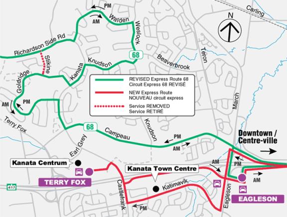
Route 68
– Revised Route in the Kanata Lakes Area (Exhibit
2)
It is
recommended that Route 68 be re-routed within the Kanata Lakes community to
provide a shorter and faster trip for the majority of customers.
At the end of 2002, critical roadway links were completed in Kanata Lakes to allow express Route 68 to serve the residential sections of the community along the entire length of Goldridge Drive. This link allowed express service to operate closer to a large section of the residential community that was previously beyond convenient walking distance of transit service on Kanata Avenue. However, on this current routing, the majority of customers along Goldridge Drive are subject to a longer travel time as they are picked up first and then travel along Walden Drive and Weslock Way before the direct trip to downtown.
With the recommended routing, Route 68 would start at Richardson Side Road and Stikine Drive and would travel along Walden Drive, Weslock Way, and Knudson Drive before serving Goldridge Drive, and then would operate on the present route via Kanata Avenue and Campeau Drive to downtown.
Approximately 250 passenger
trips each day on Goldridge Drive would benefit from an eight-minute travel
time saving, while approximately 175 passenger trips each day from the Walden
Drive and Weslock Way areas would have a travel time increase of four minutes.
Peak period express service along Stikine Drive would be removed; passengers using the bus stops on Stikine would have access to Route 68 at Stikine and Goldridge Drives or at Stikine Drive and Richardson Side Road.
During the consultation period, 14 comments were received, with 13 in favour and one opposed to the proposal. Most were pleased with the travel time savings for residents in the Goldridge Drive area and suggested adding additional trips to accommodate the increased demand for service. The one comment opposed to the change disagreed with the longer routing for customers in the Walden Drive and Weslock Way area.
Overall, the change to Route 68 would benefit more customers with a travel time saving than it would inconvenience.
SOUTH NEPEAN
The recommended changes for
South Nepean would introduce all-day and express service to the new residential
subdivisions located near Berrigan Drive and Cresthaven Drive, would provide a
new peak period service linking Fallowfield and Greenboro Stations via the Rideau
Heights Business Park and Hunt Club Road, and would improve the local service
by reducing travel time and the number of transfers required for customers.
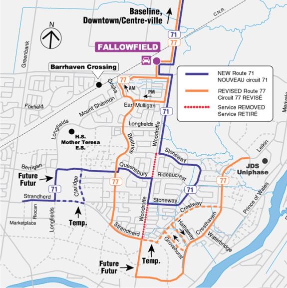
Express Route 77 and New
Express Route 71 (Exhibit 3)
It is
recommended that express Route 77 be divided into two routes, with one route
serving Berrigan, Queensbury, and Stoneway Drives and another serving Beatrice
and Cresthaven Drives. This change
would introduce express service to and from downtown to the new residential
areas in the vicinity of Berrigan Drive and Cresthaven Drive, as well as
improve the travel time for many customers using the existing express Route 77.
Express Route 77 currently
offers service to the Longfields, Davidson Heights, and Chapman Mills
subdivisions in South Nepean. This
route has been extended over the years to accommodate growth to provide peak
service coverage resulting in lengthy travel times for some customers,
specifically in the Davidson Heights community. Customers in the new communities of Chapman Mills and Havenlea,
located east of Crestway and Leikin Drives, have no convenient access to
transit service, as the walking distance to their nearest service, Route 176 on
Crestway Drive, is between 500 and 1,500 metres. Recently, however, these
communities have developed and expanded with sufficient population to divide
Route 77 into two routes, with one route serving this community. The revised
route would operate on Leikin Drive, Cresthaven Drive, Woodroffe Avenue,
Strandherd Road, and Beatrice Drive, and would then continue to downtown.
It is projected that 400 new
customer trips would be made to or from the stops along Cresthaven and Leikin
Drives. Present customers along
Beatrice Drive would not experience any change in travel time. This change would cause an inconvenience for
some existing customers by increasing the walking distance to their closest bus
stop with express service.
Approximately 30 passenger trips each day at one stop on Woodroffe
Avenue between Strandherd Road and Stoneway Drive would experience an increased
walk of four minutes to the corner of Strandherd and Woodroffe.
Two sections of Cresthaven
Drive are planned to be built during the 2003 construction season. These sections will link Cresthaven Drive
with Leikin Drive in the north and Woodroffe Avenue in the south. While completion of the north link is
expected before September 1, 2003, it may be necessary to operate temporarily
on Hathaway, Grovehurst, Crestway and Strandherd Drives until the south link is
completed to Woodroffe Avenue.
Another residential
subdivision has been developed in the area bounded by Longfields, Strandherd,
and Beatrice Drives, and some new residences in this area are beyond a
convenient walking distance from transit service. To reduce the walking distances for these residents, a new Route
71 would be introduced, and it would operate along Longfields Drive, Berrigan
Drive, Queensbury Drive, Woodroffe Avenue, Stoneway Drive, and then continue to
downtown.
The new route would offer
faster service to 340 customer trips on Queensbury and Stoneway Drives. Residents from these areas would see their
travel time reduced by an average of five minutes but would also have a five
minute longer waiting time between trips.
This route would also introduce express service to a new residential
subdivision of approximately 500 units in the vicinity of Berrigan Drive. It is anticipated that 180 new customer
trips would be made on this service from the new area.
During the consultation
period, 31 comments were received from the public concerning the proposal for
express Routes 71 and 77, with 25 expressing support for the changes. The
concerns expressed included the removal of express service from a bus stop on
Woodroffe Avenue at Heritage Glen Drive, the possible overcrowding of buses in
the Davidson Heights on the proposed Route 71, and the selection of Hathaway
Drive as a temporary route for both directions of service. Some of the comments which were in favour of
the change also suggested that express Routes 71 and 77 not serve Fallowfield
Station, to offer a faster trip, and a petition was submitted requesting that
the temporary routing on Claridge Drive be adopted as the permanent routing for
express Route 71.
The parallel Hathaway and
Grovehurst Drives are both local streets and are not as wide as the collector
roads in this area such as Crestway and Cresthaven Drives. To avoid having buses meet in opposing
directions on either of these two local roadways, the recommendation has been
modified so that the temporary operation would be in one direction along
Hathaway Drive and in the other direction along Grovehurst Drive. This arrangement would minimize the
potential for traffic conflicts and would avoid having any bus stops on the
north side of Hathaway Drive, where there is no sidewalk.
In the evaluation of the
comments, it was concluded that the proposed routings for Routes 71 and 77
would minimize the walking distances for the greatest number of customers,
although in a few instances some existing customers would have a longer walking
distance. The frequency on both routes
would be set based on the anticipated ridership, and if overcrowding were to
occur, extra trips would be added in the future. Removing Routes 71 and 77 from
Fallowfield Station is not recommended because this would limit the opportunity
for transfers to other routes serving this station. Using Claridge Drive as a permanent routing for express Route 71
would further reduce walking distance for some residents, but it would reduce
the service choice for the overall residential community, and therefore the
service should remain on Berrigan Drive as a permanent routing.
Overall, the changes to
Route 77 and the introduction of Route 71 would provide improved service to
customers, and they are expected to lead to increased ridership.
Route 71 is also affected by
one of the recommendations of the separate report on rural transit
services. Some of the trips on this new
route would be extended to start or finish in Manotick.
Local Routes 170, 173, 176,
177, and 186 (Exhibit 4)
It is
recommended that local Routes 170, 173, and 177 be changed to offer direct
service to the Marketplace commercial area from most parts of South
Nepean. In addition, it is recommended
that Route 176 be extended along Cresthaven Drive to serve the new residential
subdivision of Chapman Mills and that Route 186 be re‑routed via Berrigan
Drive and Longfields Drive to better serve the residential community.
All-day local Routes 170 and
177 currently serve the communities of Longfields and Davidson Heights. Both of these routes connect the communities
to Fallowfield Station. Route 170 also offers connectivity from Longfields to
other sections of South Nepean, but residents of Davidson Heights must travel
to Fallowfield Station on Route 177 and transfer to other routes in order to
travel to other destinations in South Nepean, such as Marketplace or the Walter
Baker Centre, making for a longer and less convenient trip.
With the growing residential
population and completed roadway links, the opportunity exists to reorganize
and improve the local services. Route
177 would be replaced by an extension of Route 173. Route 173 would become a loop route operating in both directions
between Fallowfield Station in the north and Marketplace Avenue in the south.
The combined route would serve Stoneway Drive, Queensbury Drive, and a new part
of Berrigan Drive. This change would
introduce new all-day service to a growing subdivision along Berrigan Drive and
would reduce travel time by five to ten minutes for passengers on Stoneway
Drive who are currently served by Route 177 in one direction only.
Existing passengers on
Routes 173 and 177 would not be inconvenienced by this change and all would
have the option of using the new route in either direction to circulate
internally within the community. Until
the portion of Berrigan Drive between Longfields and Claridge Drives is
completed, Route 173 would serve the new area by travelling on Claridge and
Strandherd Drives.
Route 170 would also be
adjusted, to replace Route 173 on Exeter and Wessex Drives, and to replace
Route 177 on Beatrice, Mountshannon, and Earl Mulligan Drives. In these areas, Route 170 would offer a new
connection to the Marketplace commercial centre. In addition, Route 170 would provide two-way service in some
areas currently served with a one-way loop service on the current Route
173. This would reduce travel time by
five to ten minutes for passengers with one-way service on Exeter, Wessex, and
Beatrice Drives. Passengers riding through the new areas on Route 170 would
have a trip that is two to four minutes longer than the current routing.
Route 176 currently operates
on Leikin Drive, temporarily on Crestway Drive, and along Woodroffe Avenue,
between Merivale Road and Fallowfield Station.
This route would be extended further south into the Chapman Mills
subdivision to offer all-day service to a rapidly growing residential
subdivision. It is projected that
approximately 140 customer trips each day would be made on the service in this
community. Similarly to express Route
77, described earlier, Route 176 may follow a temporary routing on Hathaway,
Grovehurst, Crestway, and Strandherd Drives, until Cresthaven Drive is complete
to Woodroffe Avenue.
Passengers from the Chapman
Mills subdivision would have their walking distance reduced and would no longer
have to walk out to Crestway Drive.
Passengers near Crestway Drive, where service would be removed, would
retain local service nearby on either Stoneway Drive (Route 173) or Woodroffe
Avenue (Route 176).
Route 186
Route 186 currently operates
between Fallowfield Station and Manotick via Fallowfield Road, Greenbank Road,
and Jockvale Road. This route would be
re-routed into the Longfields community to improve the level of all-day service
along Berrigan Drive and Longfields Drive.
During the public
consultation period, 41 comments were received concerning local Routes 170,
173, 176, and 177, with 33 expressing support for the recommended changes. Two
comments expressed opposition to the proposal for Route 170, citing the
increased travel time and the removal of service on Berrigan Drive. Some of the comments in agreement also
suggested having the proposed Route 173 travel permanently on Claridge Drive
and closer to Mother Teresa High School.
The removal of Route 170
from Berrigan Drive between Greenbank Road and Longfields Drive was approved as
part of Transplan 2000. Due to delays
in the completion of Longfields Drive, this change has been delayed until April
20, 2003. As a result of the
recommended change, some customers using Route 170 on Berrigan Drive would have
less frequent service, but all would remain within a convenient walking
distance of service. Mother Teresa High
School, which is currently served by Route 177, would be approximately 500
metres away from the nearest stop on the combined Route 173, or customers could
transfer between Routes 173 and 170 at the intersection of Beatrice and
Queensbury Drives, for a closer service.
The need for a direct school service between the areas served by Route
173 and Mother Teresa High School will be reviewed as part of the special
school service program coordinated between the school boards and OC Transpo.
Overall, the changes to the
local service would offer more direct connections to residents in South Nepean
to destinations such as the Walter Baker Centre, John McCrae High School, and
Marketplace Avenue, and would bring all-day service closer to new residents.
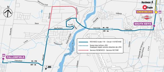
Route 119 – New Service from
Fallowfield Station to Greenboro Station (Exhibit 5)
It is recommended that Route
119 be modified to travel from Fallowfield Station to Greenboro Station in the
morning peak period and from Greenboro Station to Fallowfield Station in the
afternoon. Supplemental trips would
continue to be provided as required to accommodate shift changes at JDS
Uniphase.
From Fallowfield Station, the new route would run east on Fallowfield Road, north on Merivale Avenue, east through the Rideau Heights business area, and east on Hunt Club Road toward Greenboro Station. The times of trips would be coordinated with the times of the O-Train service at Greenboro Station, to offer a convenient service between South Nepean and Carleton University and the other destinations along the O-Train line.
Route 119 now offers service in the off-peak direction, from Greenboro Station to JDS Uniphase in South Nepean in the morning and afternoon, and from JDS Uniphase to Greenboro Station in the afternoon and evening. These trips would continue, but their route would be changed to operate via MacFarlane Road instead of via Hunt Club Road and Merivale Road, to provide a faster trip. Changes to these trips would be made as required to suit the changing travel demands of customers travelling to or from JDS Uniphase.
Travel surveys have shown that many residents of South Nepean travel to work locations in the southeast sector of the City, such as the hospital complex on Smyth Road and Confederation Heights. Transit service between these parts of the City is much slower than making the trip by car. By providing a direct link between South Nepean and Greenboro Station, customers would save travel time and the service would attract new riders.
It is projected that approximately 500 new passenger trips per day would be attracted to the new service, and that number would rise with the anticipated residential growth of South Nepean. The increased number of students in universities in September 2003 could also contribute additional passengers for this route.
During the period of consultation,
28 comments were received, all in favour of this proposal. One of the comments suggested that the route
operate outside peak periods, to cover more of the times at which customers
travel to or from Carleton University; staff will consider this suggestion as
the detailed schedule is developed.
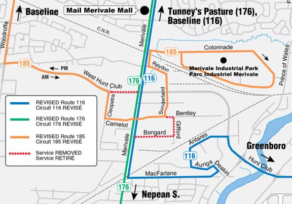
MERIVALE BUSINESS PARK
The recommended service
changes for the Merivale Business Park would replace deviations made on Routes
116 and 176 with a deviation on Route 185 during the peak periods only. This change would result in a travel time
savings of four to six minutes for the majority of passengers traveling through
the area on Merivale Road. Route 185
would also offer a new service to businesses located on Sunderland Street and
Roydon Place.
Routes 116, 176, and 185 (Exhibit 6)
It is
recommended that Routes 116 and 176 travel on Merivale Road, between West Hunt
Club Road and Bongard Avenue, during all time periods, and that Route 185 serve
the Cleopatra, Camelot, Bentley, Sunderland, and Roydon areas of the Merivale
Business Park during the peak periods only.
Routes 116 and 176 currently
serve the employment areas a short distance to the east and to the west of
Merivale Road. The majority of these
areas are within a convenient walking distance of Merivale Road. The deviations cause an inconvenience for
the majority of customers.
During the peak periods, the
deviation made by Route 116 on Bentley Avenue, Gifford Street, and Bongard
Avenue would be removed, to reduce travel time for the majority of
customers. All trips on Route 116 would
travel through the Merivale Business Park on Merivale Road. This change would save from four to six
minutes for approximately 500 passenger trips each day. Approximately five passenger trips each day
from the Gifford Street area would have an additional five-minute walk to
service on Route 185 at the intersection of Bentley Avenue and Sunderland
Street. Passengers from Bongard Avenue
would remain within a five-minute walk of service on Merivale Road.
Route 176 would no longer
operate on Cleopatra and Camelot Drives.
This would save from four to six minutes of travel time for
approximately 760 passenger trips each day. During the peak periods, service to
this area would be retained on Route 185 for approximately 25 passenger
trips. At other times of the day, most
businesses along Cleopatra and Camelot Drives would remain within a convenient
walk of the service on Merivale Road.
Approximately eight customers would have a longer walking time to their
nearest bus stop during off-peak times.
During the peak periods,
Route 185 would offer a peak service through the Merivale Business Park on
Cleopatra Drive, Camelot Drive, Bentley Avenue, Sunderland Street, and Roydon
Place. This change would add four minutes
to the trip times of approximately 40 customer trips on using Route 185 to and
from Colonnade Road.
During the public
consultation, four comments were received on this proposal and three were in
favour. One objected to the longer walk
to reach Route 176.
Overall, the changes to
Route 116, 176, and 185 would benefit the majority of customers by reducing
their travel time and would encourage increases in ridership.
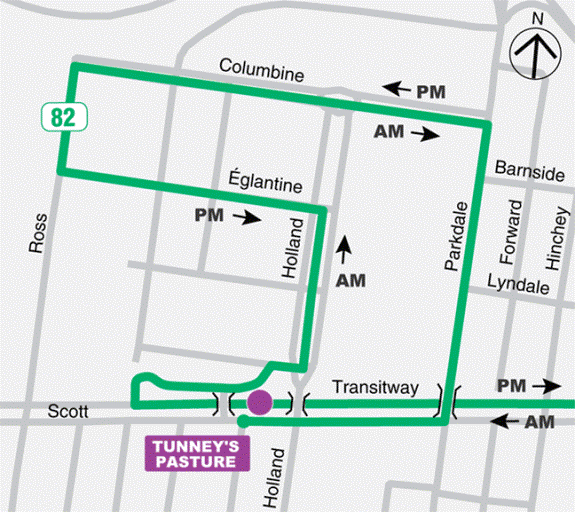
TUNNEY’S PASTURE
The recommended
service change for the Tunney’s Pasture area would extend Route 82 to Parkdale
Avenue north of Scott Street. Route 82
operates during the peak periods and serves the Tunney’s Pasture office
complex. The recommended change to
Route 82 would increase service for residents north of Scott Street and
facilitate their access to and from Tunney’s Pasture Station.
Route 82 (Exhibit 7)
It is
recommended that Route 82 be extended to offer service during the peak periods
between Parkdale Avenue and Tunney’s Pasture Station.
Currently, Route 82 provides
a service to the employment area of Tunney’s Pasture from the Transitway,
downtown, and the Alta Vista community.
There is an opportunity to adjust Route 82 through Tunney’s Pasture once
all the work trips have been made in the morning to allow for an extension of
service from the residential community along Parkdale Avenue north of Scott
Street.
During the morning peak
period, Route 82 would travel along its current routing to the Tunney’s Pasture
Station. From the station, buses would
travel north on Holland Avenue, west on de l’Églantine Street, north on Ross
Avenue, east on de la Columbine Boulevard, south on Parkdale Avenue, and west
on Scott Street to return to Tunney’s Pasture Station. Inside the Tunney’s Pasture complex, the morning
routing would be the reverse of the current afternoon routing.
During the afternoon peak
period, Route 82 would start at Tunney’s Pasture Station, travel east on Scott
Street and north on Parkdale Avenue to de la Columbine Boulevard. Presently,
Route 82 begins at the intersection of Parkdale Avenue and de la Columbine
Boulevard. Existing passengers on Route
82 would not be affected by this route extension during this time period.
This change would increase
the frequency of buses passing along Parkdale Avenue north of Scott Street,
improve service for residents of Mechanicsville, and provide a connection to
the Transitway during the peak periods.
Approximately 2,500 residents live in the Mechanicsville neighbourhood
near Parkdale Avenue, north of Scott Street.
While some in this area now use Route 6 on Parkdale Avenue, it operates
at only a 30-minute interval. Consequently, some residents in this area walk up
to 15 minutes to Tunney’s Pasture Station.
No comments were received
regarding this change during the consultation period.
Overall, this change would
improve the service level of residents along Parkdale Avenue north of Scott
Street and would encourage ridership.
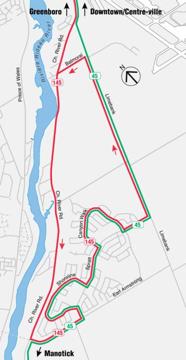
OTTAWA SOUTH
Route 196 –
Riverside South (Exhibit 8)
It is recommended
that Route 196 be revised within the Riverside South community to provide new
all-day service to the eastern part of the community, to take advantage of the
new link of Spratt Road to Limebank Road, and to accommodate the expected
closure of the temporary access road from Shoreline Drive to River Road.
Route 196 now provides local
all-day service from the community of Riverside South to Greenboro
Station. The route operates via River
Road and enters the community at a temporary roadway between River Road and
Shoreline Drive. This temporary access
is scheduled to close once Spratt Road is complete to Limebank Road, later in
2003. This closure will leave Spratt
Road and Earl Armstrong Road as the two ways to enter the Riverside South
community.
With the new route, buses
would operate south to Riverside South via River Road, then east on Earl
Armstrong and north into the community on Spratt Road. Buses would return north via Shoreline
Drive, Spratt Road, Canyon Walk Drive, Spratt Road, Limebank Road, Balmoral Road,
and River Road.
The new route would bring
approximately 95% of the residents of Riverside South within a five minute walk
of their nearest bus stop.
Customers who travel to or
from the stops on River Road between Balmoral Road and Earl Armstrong Road
would be served only by buses heading south on River Road and returning north
via Riverside South and Limebank Road.
While they would have a longer travel time of approximately five minutes
on their northbound trip, they would no longer need to cross River Road to
reach their bus stops. Approximately 30
customer trips each day would be affected in this way.
During the period of
consultation, four customers agreed with the change to Route 196, and six
customers objected to the change as it was originally proposed. All of the comments in opposition were
opposed to the proposed removal of service from River Road, and the
recommendation has been changed to address that concern.
Overall, this change to
Route 196 would increase ridership and provide a faster trip from Riverside
South.
Service to Riverside South
would also be affected by the recommendations of the separate report on rural
transit services. The section of Route
196 south of Riverside South to Manotick is recommended for removal, and a
revision to Route 296 is recommended, to serve Riverside South. With the changes recommended in the rural
service report, Route 196 would be renumbered as Route 145 and Route 296 would
be renumbered as Route 45.
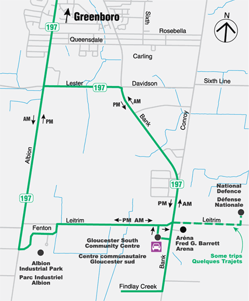
Route 197 –
Leitrim (Exhibit 9)
It is recommended
that Route 197 be extended to the new residential area of Findlay Creek, south
of Leitrim, just west of Bank Street.
It is also recommended that the direction of the route be changed in the
afternoon peak period to reduce travel time for most customers.
Route 197 currently operates
as a large one-way loop south of Blossom Park.
In the morning, passengers are taken first to employment locations along
Fenton Road and in Leitrim. The bus
then returns to Greenboro Station, picking up passengers who live in Kemp Park,
Aladdin Drive, and Blossom Park.
The new community of Findlay
Creek is under development approximately 1.5 kilometres south of Leitrim
Road. This is the first phase of
residential development in the Leitrim area, separate from the Riverside South
community. It is anticipated that approximately
70 to 100 residential units will be occupied in 2003. As the area grows further, service improvements will be
recommended.
The change in the direction of the loop in the afternoon would reduce travel time for approximately 20 customer trips each day and increase travel time for approximately five customer trips each day.
During the period of
consultation, five comments were received, and all were in favour of the
proposal.
Service on Route 197 is also
being affected by the findings of the financial performance review of transit
services, the subject of a separate report.
Service to the CFS Leitrim employment location, east of Bank Street,
will be reduced, but will still meet the travel needs at shift change times.
A small change will also be
made to Route 197 at Bank Street and Hunt Club Road. The route will be changed to operate north on Albion Road instead
of Bank Street as it approaches Hunt Club Road. This change will improve the reliability of service by avoiding
auto traffic congestion while making the left turn to Hunt Club Road.
Overall, the changes to Route 197 would result in reduced travel time for customers and are expected to lead to increased ridership.
ORLÉANS
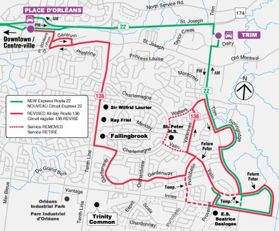
Routes 22 and 136 (Exhibit 10)
It is recommended that a new
express Route 22 be introduced and that all-day Route 136 be modified to serve
new residential communities under development along Trim Road.
The new express Route 22 would operate along Innes Road, Trim Road, and Springridge Drive, and would then continue north along Trim Road to Highway 174 for the direct trip to downtown.
This route would bring new direct peak period service to the new communities being developed east of Trim Road. These areas are now beyond a convenient walking distance of the nearest transit service. It is estimated that the new route would be used for approximately 100 to 120 customer trips each day to or from these areas in 2003, and that that number would increase substantially as the area grows.
Route 22 would also provide express service from the Trim park and ride lot to downtown, supplementing the service which currently operates on Route 95. The frequency on Route 22 would be limited initially, but would be increased as the communities grow. Route 22 would also provide an alternative to some passengers living west of Trim Road, saving them five to seven minutes of travel time compared to existing Routes 30 and 35.
The current all-day Route 136, which travels in a one-way loop around Varennes, Watters, and Valin, connecting this part of the Fallingbrook community to Place d’Orléans Station, would be extended to the new communities east of Trim Road. Route 136 would be extended when the new roads are in place and when the population of the area east of Trim Road reaches approximately 300. The change to Route 136 would also bring all-day service closer to École Secondaire Béatrice Desloges and to the Queen’s Pointe residential area centred on Provence Street north of Innes Road.
The detailed routing of Route 136 has been revised since the proposals were made earlier this year, to operate on Provence and Valin instead of Innes and Trim, and to operate clockwise around the on-street loop rather than counter-clockwise. These changes would improve customers’ access to the route and avoid time consuming unsignalized left turns.
Routes 22 and 136 would operate on temporary diversions from time to time, until the new streets are ready.
During the period of
consultation, 29 comments were received on these proposals. All eighteen comments on Route 22 were in
favour. One comment suggested that the
route start at the Valin loop rather than on Innes Road, and this change has
been incorporated into the recommendation.
Ten comments were received in support of the change to Route 136, and
one was received in opposition, citing the longer travel time required because
of the one-way service on Varennes Drive.
The evaluation showed that the benefits of the recommended change are
more important to current and future customers than the inconvenience of the
longer travel time.
Overall, these changes would
bring transit service closer to residents of the new areas and are expected to
attract new customers to transit.
CONSULTATION
A brochure describing all of the proposed service changes was distributed
on board all buses in early February.
The brochure was also distributed door-to-door and to community
associations in areas where new services were proposed for introduction. The information was also available on the OC
Transpo web pages. The brochure and the
web pages invited customers to send their comments on the proposals to OC
Transpo. Copies of the brochure were also distributed to all Councillors.
Four public open houses were held during late February in Kanata, Orléans, South Nepean, and downtown Ottawa. Several open houses were also held for staff at
OC Transpo. These allowed
frontline staff the opportunity to give feedback on proposals and to make suggestions
from the operational perspective.
Approximately 440 customers provided written comments during the
consultation period. Of these, approximately 200 were about the proposals for
service changes in Transplan 2003.
These comments are described briefly in the discussion of each
recommended service change. The
comments were helpful in bringing new issues to the attention of staff, and in
revising the recommendations so that they could provide further improvements in
service for customers.
Three of the proposals were modified based on the comments received, as
described earlier in the report.
One of the proposals has been withdrawn based on the comments received
through the period of consultation. A
proposal to revise Routes 28 and 125 to serve a future residential area near
Navan Road and Renaud Road will be evaluated again, closer to the construction
date of this new area, now expected to be two to four years away.
Some of the comments received from customers were not about the
Transplan 2003 proposals. These
comments will also be helpful and will be used in other operational and
planning work. Concerns, for instance,
about the frequency and quality of service, or about bus stops and shelters,
are already being addressed.
Suggestions for further service changes will be examined as part of the
work to prepare Transplan 2004.
Several customers suggested that Route 28 be changed to reduce the travel time from the Chapel Hill South residential area to downtown. A recommendation in the separate report on rural transit services would provide new access for customers in this area to the rural express route from Navan and Notre-Dame-des-Champs. Additional trips could be provided from Chapel Hill South on this route as demand increases.
The proposals were presented to the Transit Sub-Committee of the Mobility Issues Advisory Committee in February 2003 and were supported.
TRANSPORTATION
MASTER PLAN
The City’s Transportation Master Plan establishes a principle that travellers will be encouraged to use transit in preference to individual automobiles. The Plan calls for an emphasis on service to the central part of the City, but also improvements in transit service to major destinations outside the central area and improvements to crosstown service that does not enter the congested downtown.
The
recommendations in this report are consistent with the Transit Service Strategy
in the draft of the City’s new Transportation Master Plan.
The changes in
this report promote the aims of the Transportation Master Plan by improving
service for present transit customers and by improving service to attract new
customers. In particular, the new
connection from South Nepean to the O‑Train would attract present auto
commuters to transit, the establishment of a new hub at Terry Fox Station will
attract new transit customers in Kanata, and the extension of service into new
residential areas will serve the City’s growing travel needs.
FINANCIAL
IMPLICATIONS
The service changes recommended in this report will be accommodated within the Transit Services budget for 2003.
URBAN
TRANSIT AREA
The recommended service changes are all within the boundary of the Urban Transit Area. No changes to the boundary are required.
ATTACHMENTS
Exhibit 1 – Terry Fox Station
Exhibit 2 – Revised route in Kanata Lakes
Exhibit 3 – South Nepean express routes
Exhibit 4 – South Nepean local routes
Exhibit 5 – New service from Fallowfield to Greenboro Stations
Exhibit 6 – Merivale Business Park
Exhibit 7 – Tunney’s Pasture
Exhibit 8 – Riverside South
Exhibit 9 – Leitrim
Exhibit 10 – Orléans
DISPOSITION
Upon the approval of the service changes for
2003 by Council, staff will begin making operational arrangements and will
begin preparing public information for the service changes. Most of the changes will be introduced on
Sunday, August 31, or Tuesday, September 2.
As noted in the report, some of the service changes will be delayed but
will be introduced as soon as possible after those dates, when the construction
of new roads, new residential areas, and the new Terry Fox Station are
complete. Following the introduction of
the service changes, comments from customers and operating experience will be
monitored closely, and a full review of each change will be conducted
approximately one year after introduction.
EXHIBIT 1 - Terry Fox Station