Report to/Rapport au:
Transportation and Transit Committee/
Comité des transports et des
services de transport en commun
and Council/et au Conseil
01 June 2002 / le 01 juin
2002
Submitted by/Soumis
par: Ned Lathrop, General Manager/Directeur général
Development Services Department
/ Services d’aménagement
Contact/Personne-ressource: Vivi Chi, P. Eng., Manager Transportation
Infrastructure/
Gestionnaire, Infrastructure
des transports
580-2424
Ext 21877, vivi.chi@ottawa.ca
|
|
|
Ref N°: ACS2002-DEV-POL-0024 |
SUBJECT: RIDEAU CANAL PEDESTRIAN CROSSING
PLANNING AND ENVIRONMENTAL ASSESSMENT STUDY
OBJET: PASSAGE PIÉTONNIER AU CANAL RIDEAU
ÉTUDE DE PLANIFICATION ET D’ÉVALUATION ENVIRONNEMENTALE
REPORT RECOMMENDATIONS
That the Transportation and Transit Committee recommend Council
approve:
1.
The plan and design
of a bridge (based on alternatives 6R1 and 6R2) to accommodate the pedestrian
and cycling demand to cross the Rideau Canal between Somerset Street West and
the Nicholas Street underpass near the Transitway’s Campus Station.
2.
The preparation and
filing of the Planning and Environmental Assessment Report.
RECOMMANDATIONS
DU RAPPORT
Que le Comité des
transports et des services de transport en commun approuve :
1.
Le plan et le modèle d’un pont
(selon les variantes 6R1 et 6R2) enjambant le canal Rideau entre la rue
Somerset Ouest et le passage inférieur de la rue Nicholas à proximité de la
station Campus du Transitway, afin de permettre le passage des piétons et des
cyclistes.
2.
La rédaction et le dépôt du rapport
de planification et d’évaluation environnementale.
BACKGROUND
The former Region of Ottawa-Carleton and the NCC entered into a formal agreement in 1984 which allowed for the planning, design, and construction of a new pedestrian overpass connecting the west side of the Rideau Canal to the Campus Transit Station. This new overpass was to be owned and maintained by the Region. The primary purpose of this crossing is to link the employment and residential communities within the eastern part of Centretown with the rapid transit system at the Campus Transit Station. In addition to bringing a significant number of potential transit users in close proximity with a transitway station, other benefits include improved pedestrian and cycling-related functions.
Since the development of the Agreement, numerous discussions with the NCC and Parks Canada (owner and operator of the Canal) ensued pertaining to how the new crossing would be planned and approved. Consensus was reached on the study methodology in 2000, and a consultant team was selected to undertake the planning and environmental assessment later that year. The consultant team comprised of expertise in the areas of urban design, architecture, structural engineering, and transportation planning.
The study was paid for and managed by the Region (now the City), and was conducted in collaboration with the NCC and Parks Canada. The project was planned in accordance with the requirements of the Canadian Environmental Assessment Act, the National Capital Commission’s Environmental Assessment Policy, and the Ontario Municipal Engineers Association, Municipal Class Environmental Assessment, as they applied.
DISCUSSION
Need
Many different Official Plans, Master Plans and Planning documents have included the Rideau Canal Pedestrian Crossing and considered it an important part of their infrastructure requirements by providing a pedestrian/cyclist link across the Canal to access the Transitway. This link is documented in the following agreements and plans:
·
Agreement between the NCC and former Region of
Ottawa Carleton (1984);
·
Former Regional Official Plan and Transportation
Master Plan (1997);
· Former City of Ottawa Official Plan (1991);
· University of Ottawa Campus Master Plan (1992);
· Parks Canada’s Rideau Canal Management Plan (1995);
· NCC’s Plan for Canada's Capital (1999); and
· Integrated Network of Recreational Pathways for the National Capital Region (1994).
The proposed crossing has the potential of reducing travel times for all users, especially those who are commuting along the Canal’s pathway system. Most importantly, this facility can encourage smart growth principles by offering in the order of 40,000 residents, employees and students traveling to and from the Golden Triangle, improved access to the Transitway.
Underpass vs. Overpass
An underpass and an overpass were considered as
alternative crossing solutions. A
tunnel with associated ramps to descend and ascend into and from the tunnel
would be relatively long and have a perception of decreased security. Potential users may hesitate to use an
underpass as a result of security risks and the feeling of vulnerability that
tunnel environments can create. In
addition to security considerations, undesirable activities such as graffiti,
littering and vagrancy would also be of concern.
An overpass such as a bridge has the potential
for negative effects on existing views, however, these effects may be mitigated
though bridge design. Although views
may be altered with a bridge crossing, a bridge also has the potential to
create an attractive focal point, adding value to the existing views along the
Canal corridor. A tunnel would not
alter any existing views. Nonetheless,
a tunnel would provide no opportunity to create an attractive new feature
within the Canal corridor. Tunnels, for
the reasons mentioned above are generally not regarded as attractive or
desirable.
Overall, the
evaluation of alternative crossings indicated that an overpass was the
preferred solution.
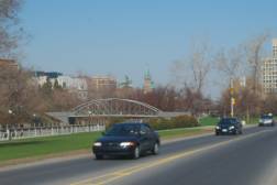
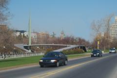
Location
The location of the crossing was influenced by the need to locate the eastern approach in close proximity to the Campus Transit Station. The alternative locations for the bridge were defined relative to this important consideration and to the overall urban street pattern in the area west of the Canal. Somerset Street West is the only street north of the bend in the Canal that connects to the Queen Elizabeth Driveway and the upper recreational pathway on the west side of the Canal. The two general locations considered are illustrated below.
- North Location - the bridge would be located to the
north of the Nicholas Street underpass between Somerset Street West and
Central Avenue.
- South Location - the bridge would be located south of the Nicholas Street underpass between Central Avenue and north of the bend in the Canal.
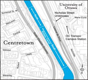
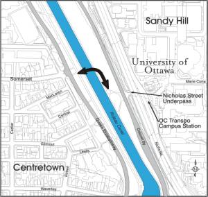
Based on the evaluation and analysis, the
preferred bridge location is in a corridor defined by the Nicholas Street
underpass on the Canal’s east side and Somerset Street West on the Canal’s west
side. See illustration below.
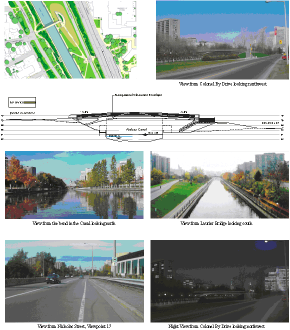
Location of the Pedestrian Bridge
Consultation with the public revealed the desire for additional pedestrian bridges in other locations. Comments received at the various Public Open Houses suggested new bridges should also be considered in locations such as between the bend in the Canal and Bank Street and across the Rideau River at Strathcona Park. Examining the need for and locations of additional bridges is beyond the scope of this study.
Planning and Design Parameters
The significance of this proposed project created the need for a rigorous planning process to be developed. Many different aspects needed to be captured in any bridge design considered. Planning and design parameters were formulated to guide the development of alternative design concepts. These parameters were developed from existing conditions and policies, and from consultation with the advisory committees, public agencies and the general public. The major parameters are as follows:
Views and Vistas - maintain or enhance the Rideau Canal and its
environs.
Contextual Environment - relationship between the contextual and heritage
environment.
Cultural Landscape - planning and design features should be adhered to in
maintaining and enhancing the Canal’s cultural landscape.
Architectural Expression - opportunity to create a new landmark for Ottawa in a
high profile setting.
Functional Requirements - overall usage, functionality and safety
considerations for year-round operation.
Physical Design - all of the major aspects of the crossing, landings and pathway
connections to ensure universal accessibility.
Bridge Configurations & Alternative Designs
Twelve alternative designs were developed using the planning and design parameters listed above for high, medium and low-level bridge options. The designs ranged from concrete to tubular steel structures that were either subtle or architectural statements on the Canal setting.
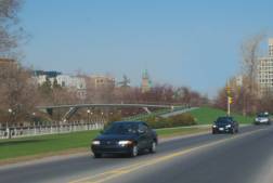
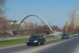
High-Level Options
The fixed high-level configurations would clear the Canal navigational envelope as well as the adjacent pathways on each side of the Canal. Providing adequate navigational clearance was an important consideration for Parks Canada’s Canal operations. The visualizations below are examples of high-level options. In addition, the NCC’s ACPDR (Advisory Committee on Planning, Design and Realty) encouraged the Project Team to explore a range of alternative structural and architectural forms. The first visualization demonstrates a design, which is subtle and minimally imposing on the viewscape. The other design frames the buildings of the Parliamentary Precinct. Physically, the east approach would be accommodated by a ramp on an earth embankment. The west approach generally would extend from the upper bank.
 |
 |
Mid-Level Options
The mid-level configuration would clear the pathway on each side of the Canal, but would encroach upon the Canal navigational envelope, requiring operation (lifting or swinging) for taller marine traffic. The east approach would require a shorter ramp facilitated by an earth embankment. The west access would extend from mid-bank requiring ramping up to Queen Elizabeth Driveway and the recreational path, and down to the west Canal pathway. Although these designs had appealing architectural elements, none of these options clear the Canal’s navigational clearance without movement of the bridge. This would involve lifting the bridge to accommodate taller boats. As a comparison, the Pretoria Bridge (a mid-level bridge), is raised approximately 550 times in a boating season – this represents about one quarter of the number of boats passing through. A mid-level bridge would involve operational requirements, increased bridge maintenance, and delays for both bridge users and Canal traffic.
Low-Level Options
The moveable low-level configuration would be at the level of the Canal walls and adjacent pathways on each side of the Canal. Clearance would not be provided for marine traffic. The bridge would have to be opened (raised or swung) for all marine craft. A low-level structure would not provide adequate clearance for skaters and ice maintenance equipment during the winter season. Clearance from the underside of the bridge deck to the ice surface would be approximately 1.5m. A ramp and stairs to the top of the west bank would facilitate access to Queen Elizabeth Driveway. A low-level configuration would involve operational requirements, increased bridge maintenance, and delays for both bridge users and Canal traffic.
Through a rigorous evaluation exercise with the Technical Advisory Committee (TAC), and Public Advisory Committee (PAC), four fixed high-level alternatives were carried forward for further refinements. This decision was confirmed by the public during the second Public Open House. The four short-listed designs are shown below:


# 5 Arch Bridge #
6 Rigid Frame
# 7 Cable Stay Bridge # 10 Curved Single Arch
Short Listed Designs
A strategy for Concept
Refinements was developed with input from the TAC and PAC, NCC’s ACPDR and the
general public. This strategy involved
the incorporation of structural and architectural modifications, which were
applied to the short-listed alternative designs. These refinements included:
·
Possible
deck width reduction;
·
Reduction
of visual effects of abutments;
·
Day
and night lighting treatment;
·
Enhancing
user experience;
·
Examination
of an asymmetrical configuration for the rigid frame bridge;
·
Exploration
of alternative tower configurations for the cable stay bridges;
·
Investigation
of providing access to the north from the east approach;
·
Examination
of a partially structured and/or switch back east ramp; and
· Examination of the possibility of a curved deck and approach for the cable stay bridges.
The refined concepts were evaluated in a similar fashion that resulted in the selection of the preferred design.
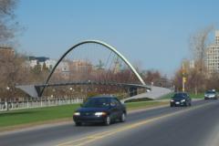
Preferred Design (Rigid Frame Bridge)
Alternatives 6R1 (Double Inclined Leg) and 6R2 (Single Inclined Leg), are high-level bridges with relatively low, gentle profiles. They are similar designs with slightly different structural support variations. Both are recommended to be carried forward for further design development.
Alternative 6R2 is an asymmetrical variation of Alternative 6R1. Alternative 6R2 responds best to the unique and different topographic conditions on either side of the Canal and as a result would be unique to this setting. However, the design is not yet refined to the point where the structure and abutment design have the simple elegance of Alternative 6R1. Both options are being advanced to the next stage of preliminary and detailed design with the intent of refining both variations for further analysis and final selection.
Both Alternatives adhere to the various design criteria identified in the Physical Design Parameters, which include a 5m wide deck or travel surface and slopes of no more that 5% for universal access. The length of the structure is in the order of 55m with ramps of approximately 115m.
These bridges fulfill the navigational clearance required by Parks Canada. There is a small vertical encroachment at the upper corners of the navigational clearance envelope, extending approximately 4.5m horizontally on the east and west sides for Alternative 6R1, leaving the centre 15m clear. For Alternative 6R2, there is a small vertical encroachment extending approximately 5m horizontally on the west side only.
Generally, the new bridge would be a visually
light, elegant, unobtrusive structure that is respectful and sensitive to the
Rideau Canal context. From every vantage point or direction of approach, the
bridge would express a high degree of lightness and transparency to maximize
views through this part of the Canal corridor. Furthermore, the bridge
structure and its approaches will provide a new contemporary landmark. The primary structure would be aesthetically
pleasing to the eye and appear in visual balance with its setting. It should
also be seen as the latest in a series of bridge crossings over the Rideau
Canal, each expressive of the structural technology of its time yet sensitive to
the wider heritage context.
Alternative 6R1:
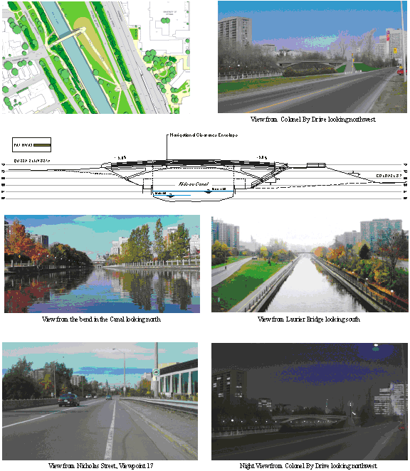
Alternative 6R2:
Other Issues to be Addressed in the Preliminary and Detailed Design
Phase
Construction Materials - The impact of this bridge on the surrounding landscape will vary depending on the materials selected. Although the preferred bridge design is subtle, the selection of bridge materials would affect its character. The design team will explore different alternatives for elements such as handrails, lighting standards/fixtures, landscaping, the cladding on the abutments and the material to be used on the bridge deck and approaches. Aesthetics and durability of the materials are both to be considered.
Skewed Alignment - Discussions with the NCC and Parks Canada revealed the desire to skew the bridge slightly, which would align the sight lines to provide a more intuitive link and better aesthetics from Somerset Street West. Both the skewed alignment and the perpendicular alignment will be carried forward to the next phase of design.
Ramps - The ramp configuration on the east side of the Canal will require design refinements. Its configuration will vary depending on the exact location of the east abutment. A switchback configuration is proposed to keep the ramp length short while maintaining all design criteria for universal access to the facility.
Central Storage Tunnel – The development of the pedestrian crossing took into consideration the Central Storage Tunnel project. This wastewater storage facility has a proposed ventilation shaft near the west abutment of the bridge. Further coordination is required in the detailed design phases of both facilities.
Queen Elizabeth Driveway - The PAC and members of the public raised the issue of pedestrian movement across the Queen Elizabeth Driveway at the western approach to the bridge. Some form of protected or signalized crossing may be warranted. The NCC has indicated that they are not supportive of any signalization on the Driveway. The configuration of the Somerset / Queen Elizabeth Driveway will be studied during detailed design to minimize conflict between users of the bridge and vehicles.
ENVIRONMENTAL IMPLICATIONS
Overall, there are no significant adverse impacts on the natural and surrounding environments. A Landscape Plan will be prepared and implemented as part of the detailed design process. The west abutment will be designed to avoid potential slope failure during construction and settling during operation. Careful attention and best practices during construction to avoid accidental spills into the Canal would be carried out. Stormwater from the bridge would be collected and directed to appropriate sewer lines.
CONSULTATION
Two consultation committees were established for this study: Technical Advisory Committee (TAC) and Public Advisory Committee (PAC). These committees met at key stages in the study to review and comment on the findings as well as participate in the evaluation of the alternative bridge designs. The TAC consisted of representatives primarily from the NCC, Parks Canada, and the City (staff with expertise in the areas of structural engineering, land use planning, property, and walking/cycling issues).
The PAC consisted of representatives from the:
· Accessibility Advisory Committee
· University of Ottawa
· LACAC – Local Advisory Conservation Advisory Committee
· Citizens for Safe Cycling
· City Centre Coalition
· Student Federation of the University of Ottawa
· Action Sandy Hill
· Women’s Action Centre Against Violence
· Federation of Citizens Association of Ottawa-Carleton
· Auto Free Ottawa
- Centretown Citizens Community Association
- Heritage Advisory Committee
- Heritage Ottawa
- Ottawa Cycling Advisory Committee
Three Public Open Houses were also held and notifications of these meetings were advertised in the daily and community papers, along with an extensive flyer distribution program. These Open Houses were well attended and there was media coverage at each Open House.
In addition, three formal presentations were made to the NCC’s Advisory Committee on Planning, Design, and Realty in an effort to seek planning and design input during the course of the study. ACPDR is generally in support of the recommended design.
Overall, there is significant public support for this crossing. It is often viewed as being “overdue” and there is considerable public desire to get underway with its design and construction as soon as possible.
FINANCIAL IMPLICATIONS
A preliminary cost estimate for the recommended bridge design is in the order of $4.5 - $5 million (in 2002 dollars) including property, design and approvals, project management, and a contingency provision.
Annual operating/maintenance costs would be in the order of $15,000.
A more accurate total project and operating/maintenance cost will be developed as detailed design is undertaken.
Currently, the capital account 900278 Rideau Canal Pedestrian Bridge identified future funds for implementation in years 2004 and 2005.
DISPOSITION
Upon Committee’s and Council’s approval of this staff report, the Planning and Environmental Assessment Report will be finalized and filed for the 30-day public review period, in accordance with the provincial Environmental Assessment Act.
Once the formal review period is over, and if there are no “Part II Order” (bump-up) requests to the Minister of the Environment, the project will be considered approved subject to fulfilling other design requirements of the NCC and Parks Canada. Detailed design could be initiated any time thereafter. This project is very much dependent on funding availability.