Report
to / Rapport au :
Transportation Committee
Comité des transports
11 April 2011 / le 11 avril 2011
Submitted by / Soumis par: Nancy Schepers,
Deputy City Manager/Directrice municipale adjointe,
Infrastructure Services and Community
Sustainability/Services d’infrastructure et Viabilité des collectivités
Contact Person / Personne ressource : Vivi Chi, Manager/Gestionnaire, Transportation Planning/Planification
des transports, Planning and Growth Management/Urbanisme et Gestion de la
croissance
(613) 580-2424 x21877, vivi.chi@ottawa.ca
|
|
Ref
N°: ACS2011-ICS-PGM-0102
|
|
SUBJECT:
|
MULTI-USE CROSSING OF THE O-TRAIN CORRIDOR NEAR HICKORY STREET ENVIRONMENTAL
ASSESSMENT STUDY – STATEMENT OF WORK
|
|
|
|
|
OBJET :
|
Étude de l’évaluation environnementale de la
passerelle polyvalente du corridor de l’o-train près de la rue hickory –
énoncé des travaux
|
REPORT
RECOMMENDATIONS
That Transportation Committee approve the Statement of
Work for the Multi-use Crossing of the O-Train Corridor near
Hickory Street Environmental Assessment Study, as detailed in Document 1.
RECOMMANDATION DU RAPPORT
Que le Comité des transports approuve
l’énoncé des travaux relatif à l’étude d’évaluation environnementale de la
passerelle polyvalente du corridor de l’O-Train près de la rue Hickory, comme
il est expliqué en détail dans le Document 1.
BACKGROUND
On
06 October 2010, the Planning and Environment Committee approved a zoning
amendment application for 125 Hickory Street. As part of that approval, the
developer (Soho Champagne Condominiums Inc.) is required to contribute funding
for the design and construction of a pedestrian bridge connecting Hickory
Street and Adeline Street over the O-Train corridor. The developer’s
contribution of $57,811 is contingent upon construction of the bridge
commencing by 15 November 2015. The City is also pursuing contributions for
the pedestrian bridge from the developers of other nearby properties. This
report describes the scope of work for an Environmental Assessment study, as a
first step towards implementing this new pedestrian/cycling crossing.
The
implementation of the pedestrian/cyclist crossing at Hickory Street is
supported by the Official Plan and other related plans and policy documents:
·
The Strategic Directions identified in the Official Plan include
the creation of environments that are pedestrian-friendly and highly favourable
to cyclists, consistent with the overall goal of creating a transportation
system that emphasizes both mobility and accessibility.
·
The Transportation Master Plan (TMP) recommends that the City
require the additional provision of pedestrian facilities that provide “direct,
high-quality pedestrian connections to rapid transit stations, bus stops and other
major walking destinations; and pedestrian crossings to link neighbourhoods
that are separated by roads or other physical barriers, where safety
considerations permit”. The TMP also states that the City will “provide
walking and cycling crossings of rapid transit corridors, where physical
constraints allow, considering the level of demand and alternative crossing
opportunities”.
·
The Ottawa Pedestrian Plan and Ottawa Cycling Plan both include a
number of supporting statements, such as the objective of creating viable pedestrian
and cycling connections across major physical barriers, the importance of
identifying and overcoming barriers to achieving pedestrian and cycling network
connectivity and a priority on linking pedestrians and cyclists to transit.
·
The Vision for the Preston-Champagne Secondary Policy Plan
identifies “enhanced open space/linkages” as a priority, highlights the pathway
linkage along the Canadian Pacific Railway (CPR) corridor from Dow's Lake to
Somerset Street as a major feature of the Greenway system within the area, and
specifically calls for improved east-west pedestrian linkages across the CPR
corridor. With regard to the O-Train corridor, the Vision also confirms the
need to minimize barriers between adjacent residential neighbourhoods by the
creation of new pathway links.
·
The Carling-Bayview Light Rail Transit Corridor Community Design
Plan study (underway) identifies a new pedestrian bridge across the O-Train
corridor at Hickory Street as part of a preliminary Open Spaces and Green
Linkages plan, and also confirms the need to increase opportunities for
east-west non-motorized linkages across the O‑Train corridor.
DISCUSSION
This Study will
be carried out as a Schedule ‘B’ Class Environmental Assessment (EA) as set out
in the Municipal Engineers Association: Municipal Class Environmental
Assessment document. A Schedule ‘B’ EA is approved under
the municipal class EA process, subject to a screening process and consultation
with directly affected members of the public and relevant review agencies.
There is no formal Environmental Study Report required, but a Project File is
created to document the screening and consultation process, and then the
project proceeds to construction.
The Canadian Environmental Assessment Act
(CEAA) defines the requirements for federal Environmental Assessments. One of
the triggers for a federal EA is when a federal department has to issue an
approval for the project under federal legislation specified in the CEAA “law
list”. Based on a review of relevant federal legislation, staff do not
anticipate that any federal department approvals will be required and therefore
do not expect that a federal EA will be required. If any federal requirements
are identified through the course of the Study, they will be addressed through
the EA process.
The
Study area will primarily encompass the O-Train corridor between Carling Avenue
and Beech Street, bounded to the east and west by Preston Street and Champagne
Avenue respectively, as shown in Figure 1 of Document 1.
The objective of the Study is to determine the best
solution for providing a pedestrian and cycling connection across the O-Train
corridor near Hickory Street by satisfying the requirements of the Municipal
Class EA Planning and Design Process for a Schedule ‘B’ undertaking, including:
·
Justification for a new pedestrian and cycling crossing of the
O-Train corridor near Hickory Street;
·
Identification and evaluation of alternative crossing solutions
and their impacts on the environment;
·
Identification of a preferred crossing solution;
·
Development of design options and a recommended design;
·
Development of a cost estimate for the total project; and
·
Consultation with stakeholders and the public.
STUDY
TIMING
It
is expected that it will take approximately six months after contract award to
complete this Study.
ENVIRONMENTAL IMPLICATIONS
The
Study will examine and evaluate the project’s environmental implications, and
will recommend appropriate mitigation measures.
RURAL
IMPLICATIONS
N/A
CONSULTATION
The
Study will involve consultation with directly affected members of the public
and relevant review agencies, as well as the City of Ottawa Urban Design Review
Panel.
COMMENTS BY THE WARD COUNCILLORS
Councillor
Katherine Hobbs: “I understand from the community that there is an eagerness
to establish this pedestrian and cyclist crossing as soon as possible. It will
serve to improve the liveability factors in the Champagne/Hickory neighbourhood
by forging stronger links between these Kitchissippi residents and the Preston
Street businesses. Providing this additional link across the O-Train trench
will enable increased cycling and pedestrian activities.
I
am a strong supporter of the proposed bridge, and support the Statement of Work
for the crossing as detailed in the report.”
Councillor Diane Holmes: “I am supportive of increased and improved pedestrian and cycling
linkages. Better access between the communities increases the liveability of
these neighbourhoods and provides for more viable business areas and improved
access to transit.”
Councillor McRae
is aware of the staff report.
LEGAL/RISK MANAGEMENT IMPLICATIONS
There
are no legal/risk management impediments to implementing the recommendations in
this report.
The
recommendations contained herein directly supports the following objectives of
the City Strategic Plan adopted by Council on 11 July 2007:
A1 Improve the City’s transportation network
to afford ease of mobility, keep pace with growth, reduce congestion and work
towards modal split targets;
D3 Reduce greenhouse gas emissions by up to
20 per cent by 2012; and
E6 Require walking, transit and cycling oriented
communities and employment centres.
TECHNICAL IMPLICATIONS
N/A
FINANCIAL IMPLICATIONS
Funds to undertake the EA study, which is estimated to
cost $100,000, are available in capital account 905390 (Pedestrian Missing
Links Studies).
SUPPORTING
DOCUMENTATION
Document 1 Multi-use
Crossing of the O-Train Corridor near Hickory Street Environmental Assessment
Study – Statement of Work
DISPOSITION
Following Committee approval of the attached
Statement of Work, staff from the Planning and Growth Management Department
will commence the process for retaining a consultant to assist with this Study.
MULTI-USE CROSSING OF THE O-TRAIN
CORRIDOR NEAR HICKORY STREET
ENVIRONMENTAL ASSESSMENT STUDY
– STATEMENT OF WORK DOCUMENT
1
City of Ottawa
Multi-use Crossing of
the O-Train Corridor near Hickory Street
Environmental
Assessment Study
STATEMENT OF WORK
1.
INTRODUCTION
The City of Ottawa is initiating an
Environmental Assessment (EA) Study for a new pedestrian and cycling crossing of
the O-Train corridor between Carling Avenue and Beech Street. This crossing near
Hickory Street would connect Champagne Avenue on the west side of the O-Train
corridor to the existing multi-use pathway on the east side of the O-Train
corridor. The Study area will generally encompass those lands bounded by
existing pedestrian facilities along Carling Avenue, Champagne Avenue, Beech
Street, and Preston Street (Figure 1).
This Statement of Work describes the City’s
intentions with respect to the methodology, public consultation and
deliverables for this Study and will form the basis for a retaining a
consultant to assist with the Study upon approval from Transportation Committee.
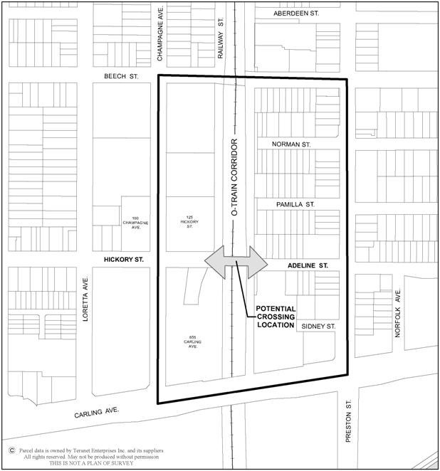
Figure 1
– Multi-use Crossing of the O-Train Corridor near Hickory Street Environmental
Assessment Study Area
2.
STUDY OBJECTIVES
This Study will be carried out as a Schedule ‘B’ Class
Environmental Assessment (EA) as set out in the Municipal Engineers
Association: Municipal Class Environmental Assessment document. Key considerations for the Study include the following:
·
Pedestrian and cyclist safety and security issues, including
lighting;
·
Connections to existing pedestrian and cycling facilities;
·
Existing requirements for the rail corridor (O-Train operations);
·
Future requirements for the rail corridor, including construction,
operating and access requirements for twinning of the tracks and the future LRT
transit station;
·
Geotechnical, grading and drainage, and municipal infrastructure
issues;
·
Full evaluation of any potential impacts on the environment;
·
Construction phasing and rail operations management during
construction;
·
Design options and costs; and
·
Consultation with local residents, community groups and relevant
review agencies.
3.
SCOPE OF WORK
The Study will proceed in two stages: Study
Design; and Project Screening (Environmental Assessment).
3.1
Study Design
At the start of the Study, a Study Design will
be developed which will identify the key components and activities of the Study
and expected deliverables. This Study Design will identify and clarify what the
main issues are, how they might be addressed, and how project resources can be
spent most effectively. It will include:
·
A project organization chart including roles and responsibilities
of project stakeholders;
·
A public/stakeholder consultation strategy;
·
A study schedule including the identification of decision and
approval milestones; and
·
An approval process/flowchart (from the start of the Study to the
finalization of detail design and commencement of construction).
3.2
Project Screening (Environmental Assessment)
The Project
Screening process will comply with provincial EA requirements and will include:
·
Justification for a new pedestrian and cycling crossing of the
O-Train corridor near Hickory Street;
·
Identification and evaluation of alternative crossing solutions
and their impacts on the environment;
·
Identification of a preferred crossing solution;
·
Development of design and aesthetic criteria for the crossing
(see below);
·
Development of design options based on the design and aesthetic
criteria;
·
The recommended functional design;
·
Identification of approval requirements; and
·
A cost estimate and preliminary schedule for the project.
The design and
aesthetic criteria component of the Study will include, but not be limited to,
the following tasks:
·
Identify the user groups who will use this facility, and their
specific design requirements;
·
Develop the design parameters and criteria for the crossing of
the rail corridor, including current (O-Train) and future proposed (e.g. LRT)
requirements;
·
Determine the appropriate dimensions for the crossing elements;
·
Define the location and alignment parameters for the proposed
crossing, including integration with the existing pedestrian and cycling
network;
·
Develop, in general terms, the criteria and appearance of the
crossing materials, including the treatment of the landing areas;
·
Identify all of the conditions and restrictions associated with
the construction and operation of the proposed bridge across the rail corridor;
and
·
Identify all jurisdictional, operational, and maintenance
associated responsibilities for the proposed pedestrian/cycling connection.
A Project File will be prepared to document the
study process including the screening process and consultation.
4. CONSULTATION
A minimum of two consultations with the general
public will be conducted, and the City will maintain a project website. The
project design will be subject to review by the City of Ottawa Urban Design
Review Panel.
Notification of Study Commencement, public consultation
events and Notice of Study Completion will be advertised in the daily
newspapers, and community papers where appropriate. Consultation summary
reports will also be completed following each public consultation event.
5. DELIVERABLES
The deliverables of this Study include:
·
Study Design report;
·
The EA Project File;
·
Public Consultation Summary Reports;
·
Functional design drawings of the preferred crossing (including
plans, profiles, structural general arrangement drawings, utility relocation
details, landscape and lighting design plans, and property requirement plans);
and
·
Any special considerations required for construction of this
project over an active rail line.