Report
to/Rapport au :
and Council / et au
Conseil
04 November 2010 / le 04 novembre 2010
Submitted by/Soumis par : Nancy Schepers, Deputy City Manager/Directrice
municipale adjointe, Infrastructure Services and Community
Sustainability/Services d 'infrastructure et Viabilité des collectivités
Contact /Personne ressource : Vivi Chi, Manager/Gestionnaire,
Transportation Planning/Planification des transports, Planning and Growth
Management/Urbanisme et Gestion de la croissance (613 580-2424 x 21877, Vivi.Chi@ottawa.ca
SUBJECT:
|
LEITRIM ROAD
REALIGNMENT ENVIRONMENTAL ASSESSMENT - RECOMMENDED PLAN |
|
|
|
OBJET :
|
ÉVALUATION
ENVIRONNEMENTALE DE LA MODIFICATION DU TRACÉ DU CHEMIN LEITRIM - PLAN
RECOMMANDÉ |
REPORT RECOMMENDATIONS
That the Transportation Committee recommend that Council:
1.
Concur in the filing of an
Environmental Assessment for the southerly realignment of Leitrim Road between
approximately Bank Street and Hawthorne Road;
2.
Direct staff to prepare a land exchange agreement, subject to
the completion of the Environmental Assessment process, the outcome of such agreement to be submitted to
Committee and Council for approval.
RECOMMANDATIONS DU RAPPORT
Que le Comité des transports recommande au
Conseil :
1.
D’accepter le dépôt d’une évaluation environnementale pour la
réorientation du tracé du chemin Leitrim vers le sud, entre la rue Bank et le
chemin Hawthorne (approximativement);
2.
De donner instruction au personnel de rédiger une entente d’échange de
terrains, sous réserve de l’achèvement du
processus d’évaluation environnementale, le résultat de cette entente devant être
soumis à l’approbation du Comité et du Conseil.
Executive Summary
Assumptions and Analysis
This
report is being brought forward on behalf of the Department of National Defence
(DND) since Leitrim Road is a City-owned roadway and changes to the road
alignment are required by DND for reasons of security. DND is completing the
Environmental Assessment for this work.
CFS Leitrim is a DND facility located to the south of Ottawa’s Urban Core, in the National Capital Greenbelt. Building setbacks at CFS Leitrim do not currently satisfy the security zone requirements separating the Station from a public roadway as the property is bisected by Leitrim Road between Bank Street and Hawthorne Road. Currently, the existing footprint of the DND facility does not meet the 100-metre setback requirement between Leitrim Road and the existing infrastructure (i.e., insufficient site security zone) determined by a risk assessment completed for the facility.
The goal of the proposed project is to ensure an adequate security buffer zone (160 metres) which includes an additional (60-metre) offset to accommodate berms and landscape to reduce visual exposure to the site. This means that a no access zone needs to be created where the public are not permitted within this setback.
The study was undertaken by DND in consultation with City staff, various government agencies, and the public. This Environmental Assessment (EA) identifies and evaluates the options to address site security at CFS Leitrim. The DND is proposing a road realignment option whereby approximately a one-kilometre section of Leitrim Road will be affected.
Options Examined and Recommendation
The road options for Leitrim Road have been identified and include:
1. Status Quo: Leitrim Road remains in the present location.
2. Close this Segment of Leitrim Road: Close Leitrim Road to public within the DND perimeter between Bank Street and Hawthorne Road to allow for the required security zone.
3. Southward Realignment of Leitrim Road: Realign Leitrim Road south of the CFS Leitrim between Bank Street and Hawthorne to allow for the required security zone and to maintain the existing arterial road network in the City.
The preferred solution to address DND’s security zone requirements at CFS Leitrim is the southward realignment of Leitrim Road (Option 3).
The realignment will add approximately 150 metres of length to Leitrim
Road and will include the construction of a new crossing over the Smith
Crowding Municipal Drain. The road
realignment project will be a rural cross section, increase the right-of-way
width to 42.5 metres and include a 2.5-metre paved shoulder for cycling. As part of commissioning the Leitrim
Road realignment, DND is prepared to transfer a new 42.5-metre right-of-way to
the City and the City will transfer the existing section of the Leitrim Road
right-of-way to DND as part of a land exchange. Site
access to CFS Leitrim will be attained through two access roads located at the
east and west ends of the realigned portion of Leitrim Road.
Legal/Risk Management
Implications
There are no legal/risk management impediments to implementing this report's
recommendations.
Technical Implications
N/A
Financial
Implications
Funding for these works, estimated at over $6 M, will be provided by the
Department of National Defence. Construction will be completed by DND with
inspection by the City. There are no capital costs for the City. However, there
will be additional operating and maintenance costs associated with the 150-metre
increase in roadway length due to the realignment.
Public Works has estimated the impact on maintenance operations will be minimal as a result of the 150 meters of proposed roadway works and can be accommodated within existing maintenance budgets.
Public Consultation/Input:
Defence Construction Canada (DCC) undertook the consultation external to DND with other Federal Departments including the Canadian Environmental Assessment Agency, Public Works Government Services Canada, Environment Canada and the Department of Fisheries and Oceans, Federal Agencies including the National Capital Commission, and other stakeholders including the City, Ontario Ministry of Environment, South Nation Conservation Authority, First Nations and the public.
Public consultation took place which included two public open houses (November 2009 and December 2009). Attendees generally supported the project.
RÉSUMÉ
Hypothèses et analyse:
Le présent rapport est soumis au nom du ministère de la
Défense nationale (MDN), étant donné que le chemin Leitrim est une route qui
appartient à la Ville et que le MDN nécessite des modifications au tracé de
cette route pour des raisons de sécurité. C'est le MDN qui procède à
l'évaluation environnementale de ce projet.
La SFC Leitrim est
une installation du MDN située au sud du secteur urbain d'Ottawa, dans la
ceinture de verdure de la capitale nationale. La marge de retrait des immeubles
de la SFC Leitrim n'est pas suffisante à l'heure actuelle, compte tenu de la
zone de sécurité qui doit exister entre la station et une voie publique. En
effet, le chemin Leitrim traverse la SFC entre la rue Bank et le chemin
Hawthorne. L'empreinte actuelle de l'installation du MDN ne satisfait pas au
critère qui exige une marge de retrait de 100 mètres entre le chemin Leitrim et
l'infrastructure existante (zone de sécurité insuffisante), selon l'évaluation
des risques dont cette installation a fait l'objet.
Le projet vise à
assurer une zone tampon (160 mètres), soit un retrait supplémentaire de 60
mètres avec talus et aménagements paysagers, destiné à réduire l'exposition du
site. Cela signifie qu'il faut créer à l'intérieur de ce retrait une zone
interdite d'accès au public.
L'étude a été menée
par le MDN, qui a consulté le personnel de la Ville, divers organismes
gouvernementaux et la population. L'évaluation environnementale définit et
évalue les différentes façons de satisfaire aux exigences de sécurité à la SFC
Leitrim. Le MDN propose une modification du tracé de la route sur une longueur
d'environ un kilomètre.
Options examinées et recommandation
Voici les options de modification du tracé de
la route qui ont été présentées pour le chemin Leitrim :
- Statu quo – Maintien du chemin Leitrim à son emplacement actuel.
- Fermeture de ce tronçon du chemin Leitrim – Interdire au public l'accès au chemin Leitrim dans les limites du
périmètre du MDN entre la rue Bank et le chemin Hawthorne afin d'être en
mesure de mettre en place la zone de sécurité requise.
- Réorientation du chemin Leitrim vers le sud – Réaligner le chemin Leitrim pour qu'il passe au sud de la SFC Leitrim
entre la rue Bank et le chemin Hawthorne afin qu’il soit possible de
mettre en place la zone de sécurité requise.
La solution privilégiée pour mettre en place la
zone de sécurité requise par le MDN à la SFC Leitrim est celle qui prévoit la
réorientation du chemin Leitrim vers le sud.
La modification du tracé aura pour effet de
prolonger le chemin Leitrim d’environ 150 mètres. Elle nécessitera la
construction d’un passage au-dessus du drain municipal Smith Crowding. Le
nouveau tronçon, qui aura le profil d’une route rurale, possédera une emprise
élargie (42,5 mètres) et un accotement pavé de 2,5 mètres pour les cyclistes. Dans le cadre de la demande de nouveau tracé
du chemin Leitrim et d’un échange de terrains, le ministère de la Défense
nationale est prêt à transférer une nouvelle emprise routière de 42,5 mètres à
la Ville et la Ville transférera la partie existante de l’emprise routière du
chemin Leitrim au ministère de la Défense nationale. Il sera possible d’accéder au site de la SFC
Leitrim en passant par deux chemins situés aux extrémités est et ouest du
tronçon réorienté du chemin Leitrim.
Incidences juridiques / concernant
la gestion des risques :
La mise en oeuvre des recommandations du présent rapport n'a
pas d'incidence juridique ni d'incidence concernant la gestion des risques.
Incidences techniques:
S.O
Répercussions financières:
C'est le ministère de la Défense nationale qui assurera le
financement des travaux, dont le coût est évalué à plus de 6 millions de
dollars. Le MDN effectuera les travaux, qui seront soumis à l'inspection de la
Ville. Le projet n'entraîne pas de coûts d'immobilisations pour la Ville.
Celle-ci assumera toutefois les frais d'exploitation et d'entretien
supplémentaires engendrés par le prolongement de ce tronçon de route sur 150
mètres.
Travaux publics
estime que le prolongement de la route sur 150 mètres n'aura qu'un impact
minime sur les opérations d'entretien et que les budgets d'entretien actuels
permettront d'absorber les coûts.
Consultation publique /
commentaires:
Construction de défense Canada (CDC) a mené la consultation à
l'extérieur du MDN de concert avec d'autres ministères et organismes fédéraux,
y compris l'Agence canadienne d'évaluation environnementale, Travaux publics et
Services gouvernementaux Canada, Environnement Canada, le ministère des Pêches et
des Océans et la Comission de la capitale nationale, ainsi qu'avec d'autres
intervenants, dont la Ville d'Ottawa, le ministère de l'Environnement de
l'Ontario, l'Office de protection de la nature de la Nation-Sud, les Premières
Nations et la population.
La consultation publique a consisté en deux réunions portes ouvertes, aux mois de novembre et de décembre 2009. Dans l'ensemble, les participants étaient favorables au projet.
BACKGROUND
This
report is being brought forward on behalf of the Department of National Defence
(DND) since Leitrim Road is a City-owned roadway. DND is completing the
Environmental Assessment for this work.
The Canadian Forces Station (CFS) Leitrim, established by the Royal Canadian Corps of Signals in 1941 is located at 3545 Leitrim Road. CFS Leitrim is a DND facility located to the south of Ottawa’s Urban Core, in the National Capital Greenbelt. Building setbacks at CFS Leitrim do not currently satisfy the security zone requirements separating the Station from a public roadway as the property is bisected by Leitrim Road between Bank Street and Hawthorne Road. Presently, the existing footprint of the DND facility does not meet the setback requirement between Leitrim Road and the existing infrastructure (i.e., insufficient site security zone) determined by a risk assessment completed for the facility.
The goal of the proposed project is to ensure an adequate security buffer zone (160 metres) which includes an additional (60-metre) offset to accommodate berms and landscape to reduce visual exposure to the site. This means that a no access zone needs to be created where the public are not permitted within this setback.
The study was undertaken by DND in consultation with City staff, various government agencies, and the public. This EA identifies and evaluates the options to address site security at CFS Leitrim. The DND is proposing a road realignment option whereby approximately a one‑kilometre section of Leitrim Road will be affected.
DISCUSSION
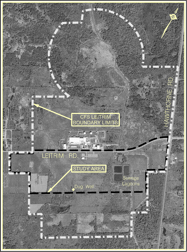
Leitrim Road divides CFS Leitrim into two sections, where approximately 60 per cent of DND’s property (139 hectares) is north of Leitrim Road and 40 per cent of DND’s property (97 hectares) is south of Leitrim Road. The site is described as a portion of Lot 15 and most of Lot 16, in Concession 5, Rideau River Front, situated on the boundary of Ward 10 and Ward 20.
The Study Area is located along Leitrim Road between Bank Street and Hawthorne Road. It extends from the limit of DND property in the west to the limit of DND property in the east incorporating the DND lands. This project is proposed in the area of the existing Leitrim Road and approximately 55 hectares of DND property (at CFS Leitrim) adjacent to the south of Leitrim Road.
CFS Leitrim boundary limits and the study area are shown in Figure 1.
Figure
1: Boundary Limits
The study objectives include:
· Ensure that CFS Leitrim security buffer zone requirement is met;
· Any proposed road configuration changes would comply with the City’s Official Plan (OP), Transportation Master Plan (TMP) design guidelines, standards and specifications.
· Improve safety on Leitrim Road (i.e., decrease conflict points) for all road users;
· Conduct an Environmental Assessment in accordance with provincial and federal requirements; and,
· Minimize negative effects to biophysical, socio-economic and cultural environments and identify mitigation measures.
Options Examined and Recommendation
The road options for Leitrim Road have been identified and include:
1. Status Quo: Leitrim Road remains in the present location.
2. Close this Segment of Leitrim Road: Close Leitrim Road to public within the DND perimeter between Bank Street and Hawthorne Road to allow for the required security zone.
3. Southward Realignment of Leitrim Road: Realign Leitrim Road south of the CFS Leitrim between Bank Street and Hawthorne to allow for the required security zone and to maintain the existing arterial road network in the City.
A summary of the evaluation of these options is shown in Table 1. The preferred solution to address DND’s security zone requirements at CFS Leitrim is the southward realignment of Leitrim Road (Option 3). This option produced the best results or lowest score.
|
Table 1: Options Evaluation Ranking: 1 – Good, 2 – Moderate, 3 – Poor |
|||
|
Factors |
Option 1 |
Option 2 |
Option 3 |
|
Status
Quo |
Close
this Segment |
Southward
Realignment |
|
|
of
Leitrim Road |
of
Leitrim Road |
||
|
Security Zone Compliance |
Does not meet
security requirements at CFS Leitrim. |
Meets security requirements
at CFS Leitrim. |
Meets security requirements
at CFS Leitrim. |
|
3 |
1 |
1 |
|
|
Biophysical Environment |
Biophysical environment
will be maintained as existing. No improvements or effects. |
Effect on
biophysical environment (e.g., construction of cul-de-sacs). |
Increased effects on
biophysical environment (e.g., new culvert in municipal drain, additional
length of paved surface). |
|
1 |
2 |
3 |
|
|
Socio-Economic Environment |
Socio-economic environment
will be maintained as existing. No improvements or effects. |
Effect on socio-economic
environment (e.g., interrupted use of public arterial road and increased
traffic flow at other intersections). |
Positive effects on the
socio-economic environment by improving traffic flow along Leitrim Road (e.g.
fewer access/ conflict points, and construction of cycling lanes). |
|
2 |
3 |
1 |
|
|
Cultural
Environment |
No change to cultural
environment. |
No change to cultural
environment. |
No change to cultural
environment. |
|
1 |
1 |
1 |
|
|
Transportation
|
Complies with City’s TMP,
no road improvements, will continue to have five accesses to CFS Leitrim. |
Does not comply with City’s
TMP, adjacent local roads may require improvements to address increased
volumes and bus traffic, new arterial route may be required. |
Complies with City’s TMP,
road improvements (e.g. approximately 1150m new paved section, turning lanes,
cycling lane, reduced accesses to station, reduced conflicts), right-of-way
to meet city guidelines. |
|
2 |
3 |
1 |
|
|
Construction
Cost |
No cost |
High cost |
Moderate cost |
|
1 |
3 |
2 |
|
|
Total
Points |
10 |
13 |
9 |
|
Recommendation |
DO NOT CARRY FORWARD |
DO NOT CARRY FORWARD |
CARRIED FORWARD |
|
|
|||
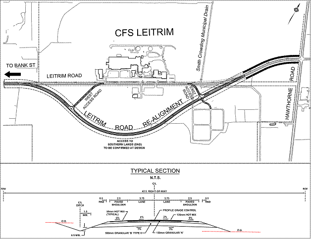
The realignment will add approximately 150 metres of length to Leitrim
Road and will include the construction of a new crossing over the Smith
Crowding Municipal Drain. The road realignment project will be a rural cross
section, increase the right-of-way width to 42.5 metres and include a 2.5-metre
paved shoulder for cycling. Site access to CFS Leitrim will be attained through
two access roads located at the east and west ends of the realigned portion of
Leitrim Road. The recommended Leitrim Road Realignment is shown in
Figure 2.
Figure 2:
Recommended Leitrim Road Realignment
Other Issues
Land Transfer, Road
Maintenance and Operation
As part of commissioning the Leitrim Road realignment, DND is prepared to transfer a new 42.5-metre right-of-way to the City and the City will transfer the existing section of the Leitrim Road right-of-way to DND as part of a land exchange. DND will follow the City’s Road Closure/Opening Bylaw process. The City will be responsible for the maintenance activities related to the new Leitrim Road realignment and DND will be responsible for the maintenance activities required on the access roads, such as road repair, and operation and maintenance activities during winter months.
Fish and Fish Habitat
The presence of fish and fish habitat were observed in two locations in the project area: in the central channel feature in the open field south of CFS Leitrim; and in a portion of the Smith Crowding Municipal Drain which runs parallel to Leitrim Road, east of CFS Leitrim. Brook Stickleback were identified in the central channel and Brook Stickleback, Central Mudminnow, Creek Chub, Finescale Dace and Blacknose Dace were identified in the Smith Crowding Drain. No aquatic species at risk were identified or recorded as occurring in or in the vicinity of the study area. Mitigative measures to reduce potential effects will include materials stockpiled, (covered and barricaded) away from areas that may have an effect on runoff, as well as construction equipment stored away from drainage areas, catch basins and water bodies.
Species at Risk
A targeted species at risk survey for the study area confirmed the presence of Monarch Butterflies and identified suitable habitat for the following five species at risk: Eastern Milksnake, Stinkpot Turtle, Spotted Turtle, Blanding’s Turtle, and Grey Fox.
The study area varies greatly from a highly urbanized
area in the west to a more rural natural area in the east. As a result, the potential impact to the
natural environment, including fisheries and terrestrial, is greatest in the
east end of the study area adjacent to the National Capital Commission’s
Greenbelt lands.
No species at risk have been found in the study area. If
a species at risk is found in the area where construction will take place,
Environment Canada will be contacted prior to the work to confirm the
appropriate protection measures. Mitigative measures will include limiting
amount of damage to nearby trees and where possible, preserving areas with
milkweed plants to maintain Monarch Butterfly habitat.
Archaeological, Heritage and Culture
The results of a Stage 1 Archaeological Assessment indicated that the project area has a low potential for the presence of significant archaeological resources due to the low lying and imperfectly drained soils. A dug well of unknown date was observed on the southern limit of the study area, and areas of archaeological potential were identified on CFS Leitrim adjacent to the study area.
No heritage sites have been identified within the footprint of the southward realignment of Leitrim Road; however, the final road realignment may encroach within 150 metres of the identified dug well. Mitigative measures will include minimizing disturbance in the area surrounding the dug well and if the road alignment falls within 150 metres buffer zone of the dug well, the Ministry of Culture will be notified. This will be addressed at the final design stage, and setbacks will be determined. The preferred option will maintain the existing cultural environment; therefore, no effect on the cultural environment is anticipated.
Noise and Vibration
CFS Leitrim is located on the southern edge of the National Capital Greenbelt and is primarily surrounded by rural land. DND has determined that no further study is required as the new alignment is not in proximity to sensitive land uses, has sufficient setback to residential areas, will not increase volume of traffic or travel speed and is entirely surrounded by DND land.
Utilities
Impacts to utilities, such as City watermain feeder line, hydro, street
lighting, gas mains and telecommunications signify that relocation will be
required.
Stormwater Management
Drainage features at the site are part of the Bear Brook drainage system in the South Nation watershed, under the South Nation Conservation Authority jurisdiction. Onsite drainage features include designated permanent and intermittent water bodies by the Rideau Valley Conservation Authority and classified as Urban Waterways by the City. Surface water features observed during site investigations conducted in the study area include the:
· Smith Crowding Municipal Drain;
· Central drain;
· Sewage lagoons;
· Wetted areas; and,
· Surface ditches.
The Smith Crowding Municipal Drain is a tributary of the Bear Brook. The drain flows in a north-south direction crossing under Leitrim Road east of the CFS Leitrim facilities. The central channel is located directly south of the CFS Leitrim facility in a meadow area, extending west from the tree line towards the permanently wetted area in the meadow.
Sewage from CFS Leitrim facilities is piped to and treated in sewage lagoons located in the eastern portion of the study area south of Leitrim Road. Effluent from the lagoons can be released into the receiving stream as permitted by the Ontario Ministry of Environment (MOE) during the discharge period in the spring. DND will contact MOE if the volume of effluent becomes an issue.
Onsite drainage is directed to a network of surface ditches including roadside ditches and culverts along Leitrim Road.
Historically the study area was part of a larger wetland complex and was drained for agricultural and other uses. The study area continues to remain low-lying and wetted in areas. The shallow groundwater in the overburden at CFS Leitrim generally flows southeast with a gradient of approximately 0.02. Inferred depth to groundwater in the overburden ranges from approximately 0 to three metres. The central channel area remains wet year round, indicating this area is likely a groundwater recharge area. Local groundwater at the site may be influenced by underground utility trenches, conduits, structures, variations in soil type, and minor fluctuations in topography.
Geotechnical
The surface horizon at the CFS Leitrim is comprised of post-Champlain Sea aeolian/alluvial deposits consisting of a surficial layer of topsoil/organic material underlain by clayey silt to sandy silt, and/or silty clay underlain by glacial till. The glacial till deposit consists of sandy silt to silty sand with some gravel and cobbles. Previous environmental investigations observed varying soil textures across the site containing mixtures of clay, silt, sand and gravel. The thickness of surficial deposits ranges approximately 4.5 to six metres below grade. Fill has been identified in some areas of CFS Leitrim north of Leitrim Road up to approximately three metres in thickness containing asphalt, sand and gravel. The surficial geology at CFS Leitrim is underlain by siltstone and limestone of the Carlsbad Formation.
No areas of potential environmental concern were identified in the study area at CFS Leitrim in the Phase I Environmental Site Assessment conducted by Aqua Terre.
CONSULTATION
DND sent contact letters to the Ontario Ministry of Aboriginal Affairs,
Indian and Northern Affairs Canada (INAC) and the Algonquins of Ontario
Consultation Office. At this time, no
aboriginal communities have expressed an interest in the project.
The Ontario Ministry of
Environment (MOE) was contacted and their direct participation is not required
for Municipal Class EA’s as it is the proponent’s responsibility to evaluate
the environment and where environmental impacts are typical and easily
mitigated through standard construction mitigation measures. The MOE will be engaged if a significant
impact from the project is anticipated and falls within MOE’s technical review
mandate.
DND also consulted the National Capital Commission (NCC) as CFS Leitrim is situated within the limits of the National Interest Land Mass (NILM). Under the National Capital Act, NCC authorization is also required upon completion of the Environmental Screening for the Land Use Approval application process. The Environmental Screening report identifies that this land is not at risk.
The South Nation Conservation Authority (SNCA) participated in a pre-consultation meeting held at the City in June 2009 and was consulted as part of the fish and fish habitat study conducted by DND. In December 2009 SNCA was consulted in regards to floodplain mapping of the Smith Crowding Municipal Drain at CFS Leitrim.
The
Algonquins of Ontario (Algonquins) were contacted by the DND federal negotiator
for First Nations in the fall of 2007 with ongoing correspondence taking place throughout
the study. The Algonquins provided a letter, dated 27 April 2010, affirming
that they do not oppose the project however; they are to be notified should any
artefacts of interest be encountered.
The Public Works Department is supportive of recommendation 1. However, when introducing curves into the alignment of a higher speed road, the risk of collisions increases. These risks can be mitigated by proper design where there is an emphasis on safety in the process. An independent road safety audit should be included in the design process. Design elements that specifically need review amongst all elements are clear zones, side slopes, lighting, turning lanes and traffic control at the access points, sight lines, positive guidance, and design speed.
The final design should go through the City’s design circulation process to ensure all standards are met or exceeded. Consideration should also be given to the appropriate right-of-way given the introduction of horizontal curves and the future expansion requirements of this road.
When designing the realignment of the road, it must conform with the Urban Tree Conservation By-Law (2009-200) and the Municipal Trees and Natural Areas Protection By-Law (2006-279).
Public Open Houses (POH)
Public Open Houses were held on two separate occasions:
Public Open House #1 (16 November
2009)
The purpose of the first meeting was to consult the public on the three options. There were eight participants: two were Hawthorne residents, a City Councillor representative and the remainder from municipal, provincial and federal governments. The attendees raised questions regarding the Smith Crowding Drain, watermain, road closure, southward realignment of Leitrim Road, required buffer/security zone, cross walk, potential for future growth of CFS Leitrim, species at risk, noise and light disturbance, risk to the DND infrastructure and explored other options to achieve the required site security zone. Attendees generally supported the project.
Public
Open House #2 (14 December 2009)
At this meeting the preferred solution and alternative design concepts were presented. There were four participants. Similar topics of discussion from Open House #1 were raised. No public feedback letters/ e-mails were received following the meeting. There was general support for the project.
COMMENTS
BY THE WARD COUNCILLOR(S)
Ward 10: Gloucester – Southgate
It is important that this project addresses community concerns and
environmental issues and that the Ontario and Federal EA processes are followed
appropriately. Since this project is
initiated by DND, there should be no cost to the City associated with the
relocation of the road, including the transfer (swapping) of property.
Although DND is responsible for the cycling and pedestrian facilities that are
only in the relocated section of roadway, these facilities should be extended
to Bank and Hawthorne to provide for a continuous east-west link. Please ensure that there are safe turning
access points at both the East and West entrances to the DND property and that
these intersections be monitored for future signals if/when the need arises.
Ward 20: Osgoode
The Councillor is aware of this report and has no comments.
LEGAL/RISK
MANAGEMENT IMPLICATIONS
There are no legal/risk management impediments to implementing this report's recommendations.
CITY
STRATEGIC PLAN
The recommendation contained herein aims to support the following
Strategic Directions adopted by Council on 11 July 2007:
E6 Require
walking, transit and cycling oriented communities and employment centres.
F4 Ensure
that City infrastructure required for new growth is built or improved as needed
to serve the growth.
TECHNICAL IMPLICATIONS
N/A
FINANCIAL IMPLICATIONS
Funding for these works will be provided by the Department of National Defence.
Construction will be completed by DND with inspection by the City. There are no
capital costs for the City. However, there will be additional operating and
maintenance costs associated with the 150-metre increase in roadway length due
to the realignment.
Public Works has estimated the impact on maintenance operations will be minimal as a result of the 150 meters of proposed roadway works and can be accommodated within existing maintenance budgets.
SUPPORTING
DOCUMENTATION
NA
DISPOSITION
Following Committee and Council approval of the functional design, Department
of National Defence will undertake the following:
·
The Environmental
Study Report documenting the entire EA process and study recommendations will
be compiled and made available to the public for a 30-day review period.
·
The public will
be notified through the posting of a “Notice of Study Completion” appearing in
the local newspapers.
·
Real Estate
Partnership and Development Office will prepare the land exchange agreement and
report to Committee and Council.