Report to/Rapport au :
Comité des transports
18 August 2009 / le 18 août 2009
Submitted by/Soumis par : Nancy
Schepers, Deputy City Manager
Directrice municipale adjointe,
Infrastructure Services and Community Sustainability
Services d’infrastructure et Viabilité des
collectivités
Contact/Personne-ressource:
Michael Murr, Acting
Director/Directeur intérimaire, Community and Sustainability Services/Services
de viabilité et des collectivités
(613) 580-2424, 25195 michael.murr@ottawa.ca
SUBJECT:
|
KING EDWARD AVENUE LANE REDUCTION
STUDY RESULTS AND NEXT STEPS |
|
|
|
OBJET :
|
RÉSULTATS DE L'ÉTUDE SUR LA RÉDUCTION
DU NOMBRE DE VOIES SUR L'AVENUE KING-EDWARD ET PROCHAINES ÉTAPES |
REPORT
RECOMMENDATIONS
That
Transportation Committee:
1. Receive the report entitled King Edward Lane Reduction Impact Study as prepared by Dillon Consulting Limited, dated August 14, 2009, a copy of which is on file with the City Clerk; and
2. Direct staff to carry out Phase II of the study as described in this report, including further consultation with relevant stakeholders, and to report on the results of this work by the end of 2009.
RECOMMANDATIONS DU
RAPPORT
Que le Comité des transports recommande:
1. De prendre
connaissance du rapport intitulé King
Edward Lane Reduction Impact Study (Étude de l'impact de la réduction du
nombre de voies sur l'avenue King Edward), produit par la société Dillon
Consulting Limited en date du 14 août 2009, et dont le greffier de la Ville
possè de une copie; et
2. De
donner instruction au personnel de réaliser la phase II de l'étude, décrite
dans le présent rapport, et notamment de mener de nouvelles consultations
auprès des parties prenantes, et de rendre compte des résultats de ces travaux
d'ici à la fin de 2009.
EXECUTIVE SUMMARY
Approved by Council in August 2008, the King Edward Avenue Lane Reduction Study has been undertaken to determine the potential transportation and community impacts of reducing the cross-section on King Edward Avenue from six lanes to four lanes between Rideau Street and Sussex Drive. City staff have worked with members of the King Edward Avenue Task Force and Dillon Consulting Limited to carry out a comparative analysis of three alternative scenarios:
- Scenario 1: Six-lane configuration
(the ‘status-quo’)
- Scenario 2: Six-lane hybrid
configuration
- Scenario 3: Four-lane configuration.
The study
assesses the impact of these lane configurations on a number of community
impact factors (e.g. air quality, noise and urban design) and on various
transportation users (e.g. motorists, pedestrians and transit).
The study
provides a firm understanding of the relative differences between each scenario
and indicates that there is sufficient merit to proceed with Phase 2 of the
study to complete a proper evaluation of the impacts, consult with a broad
range of stakeholders, and to provide a final recommendation regarding a lane
reduction, if appropriate, to Transportation Committee by the end of 2009.
Financial Implications:
Funding for Phase 2 is available within the established project budget and departmental operating budget.
RÉSUMÉ
L’étude sur la
réduction du nombre de voies sur l’avenue King Edward, que le Conseil a
approuvée en août 2008, a été entreprise afin de mesurer
l’impact qu’une réduction du nombre de voies sur l’avenue King Edward pourrait
avoir sur les transports et la communauté. Cette réduction porterait de six à
quatre le nombre de voies entre la rue Rideau et la promenade Sussex. Le
personnel de la Ville, de concert avec des membres du groupe de travail sur
l’avenue King Edward et Dillon Consulting Limited, a effectué une analyse
comparative des trois scénarios
suivants :
- Scénario no 1 :
modèle à six voies (statu quo)
- Scénario no 2 :
modèle hybride à six voies
- Scénario no 3 :
modèle à quatre voies
Dans le cadre de
l’étude, on analyse l’impact de ces trois modèles en fonction de plusieurs
facteurs d’incidence sur le milieu (p. ex., la qualité de l’air, le bruit
et la conception urbaine) et sur divers usagers de la route (p. ex., les
automobilistes, les piétons et les usagers du transport en commun).
L’étude a permis
de bien cerner les différences entre chacun des scénarios, et les résultats indiquent
qu’il est pertinent de passer à la phase 2. Au cours de cette phase, on procédera à une
évaluation formelle de l’impact des modèles, on consultera un large éventail
d’intervenants et, enfin, on présentera au Comité des transports, d’ici la fin
de 2009, une recommandation finale concernant, s’il y a lieu, une
réduction du nombre de voies.
Répercussions financières
Le financement disponible pour la
phase 2 fait partie du budget alloué au projet et du budget de
fonctionnement du Service.
BACKGROUND
King Edward Avenue is a six lane arterial roadway, which currently serves multiple roles in the transportation network in central Ottawa. King Edward Avenue provides local neighbourhood access to Lowertown, an interprovincial link for commuters and commercial traffic to the Macdonald-Cartier Bridge, a public transit corridor for STO buses, and facilities for pedestrians and cyclists.
The Lowertown community has long felt that the interprovincial and mobility functions on King Edward Avenue have overshadowed the needs of the local residents and businesses. The King Edward Avenue Task Force was formed specifically to lobby the City to implement measures to mitigate the impact of King Edward Avenue operations on the community.
At its meeting of 15 October 2008, the Transportation Committee
approved the Terms of Reference (ToR) for the King Edward Avenue Lane
Reduction Study (ACS2008-PTE-DCM-0005).
The study has been undertaken to determine the potential transportation
and community impacts of reducing the cross-section on King Edward Avenue from
six lanes to four lanes between Rideau Street and Sussex Drive. It is important to note that as stated in
the approved ToR, this phase of the study was not intended to provide a
detailed evaluation of the specific impacts nor recommend a particular lane
configuration.
City staff have worked with members of the King Edward Avenue Task
Force and Dillon Consulting Limited (the KEA Study Team) to carry out the
study and assess the community and transportation impacts of three alternative
scenarios:
- Scenario
1: Six-lane configuration (the ‘status-quo’)
- Scenario
2: Six-lane hybrid configuration
- Scenario
3: Four-lane configuration
This report discusses the actions taken since the last report to
assess the lane reduction scenarios and seeks approval to carry out a
subsequent phase of work to complete the evaluation and undertake broader
consultation with relevant stakeholders, with the intent that a specific lane
reduction recommendation, if appropriate, could be brought forward to Committee
by the end of 2009.
DISCUSSION
Scope of Study and
Analysis Framework
The KEA Lane Reduction Study assesses both the community and
transportation impacts of three lane reduction scenarios.
Transportation Impact Assessment
The transportation impacts were assessed using a quantitative
analysis that relied on computer modelling using the VISSIM software package.
In addition, more detailed assessment at the intersection level was
subsequently undertaken using the Synchro software model. Both software
packages are standard assessment tools used to assess potential transportation
impacts.
The transportation analysis considered mobility for interprovincial
traffic, interprovincial goods movement, movement within Lowertown, access for
vehicular traffic to and between Lowertown and the Byward Market, transit and
overall safety. The transportation impact assessment was assessed on the
following groups:
- motorists
- pedestrians
- cyclists
- transit
- goods
movement.
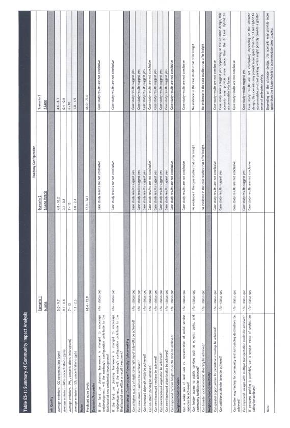
Community Impact Assessment
The effect of the roadway's design was assessed on the following
community impact factors:
- air
quality
- noise
- economic
prosperity
- urban
design/streetscape/identity/place-making
- neighbourhood
cohesion
- neighbourhood
connectivity
- safety.
For most of the community impacts, a qualitative analysis was used
that incorporated a review of case studies from other juridictions where
similar study or lane reduction had taken place. However, impacts such as air
quality and noise were determined using computer modelling and therefore have
quantitative results.
Analysis Framework
A series of criteria were identified by the KEA Study Team to
properly assess the lane reduction impacts and ensure that specific impacts
from a potential lane reduction would be clearly identified and measured. All
quantitative measures needed to be output from a recognized model and/or viable
methodology. All qualitative measures
would ideally be demonstrated in a relevant case study, and allow for a clear
‘yes’ or ‘no’ opinion to be rendered.
These criteria are discussed more fully in the 'Impact Assessment of
Scenarios' section of this report.
Roadway Scenarios
The KEA Study Team considered a variety of alternative roadway
scenarios and selected three, on a consensus basis, for comparison purposes in
the study. The following three scenarios were felt to provide the best insights
for the transportation and community impact assessment:
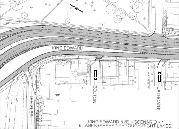
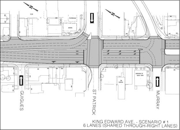
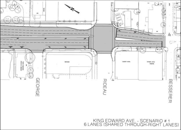
Scenario 1: Six-lane Configuration
Considered to be the 'status-quo', the six lane configuration is
currently being constructed as per the construction contract for King Edward
Avenue. In the southbound direction, it includes three 'through lanes', double
left turn lanes at St. Patrick Street and Murray Street, and shared
through-right lanes at all intersections except Rideau Street where the third
lane becomes an exclusive right‑turn lane. In the northbound direction, a
third through lane is developed immediately north of Rideau Street and is
carried through the entire corridor to Boteler Street where the third lane
becomes a ramp to Sussex Drive.
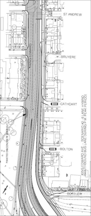
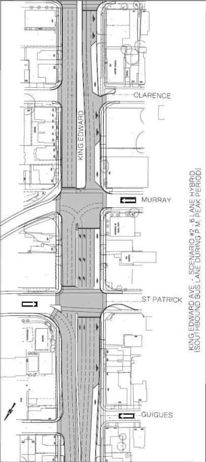
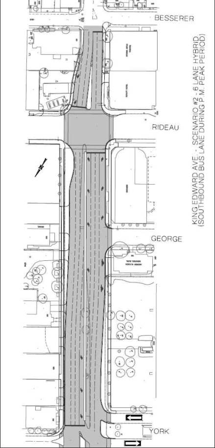
Scenario 2: Six-lane Hybrid Configuration
This scenario includes three 'through lanes' in the southbound
direction with the curb lane (between Bruyère Street and York Street) being
designated for transit vehicles only during the afternoon peak period and
parking at all other non-peak periods. As with scenario 1, this configuration
also includes double left turn lanes at St. Patrick Street and Murray Street,
and shared through-right lanes at all intersections except Rideau Street where
the third lane becomes an exclusive right-turn lane. In the northbound direction, a third through lane is developed
immediately north of Rideau Street and is carried through to St. Andrew Street
at which point the curb lane is designated as a 'right-turn only' lane to
facilitate access into the neighbourhood and to prevent motorists from using
the curb lane as a queue jump to gain faster access the bridge.
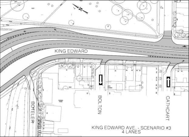
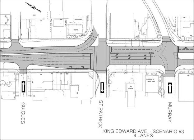
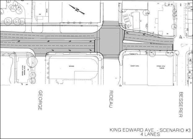
Scenario 3: Four-lane Configuration
The four-lane configuration is essentially the same cross-section as
was proposed in the previous EA study; two 'through lanes' are maintained in
both southbound and northbound directions from Rideau Street to the
MacDonald-Cartier bridge ramp with auxiliary turn lanes at key locations (southbound
double left turn lanes at St. Patrick Street, and exclusive southbound right
turn lane to access the Sussex Drive ramp, with all other right turns shared
with a through lane).
For reference purposes, cross sections of key intersections for each
of the above scenarios is attached as Document 2.
Results of Case Studies
A review of relevant case studies from other jurisdictions was
undertaken to provide insight into the conditions, rationale and the result(s)
of the lane reduction as the basis for providing the qualitative input needed
for the community impact assessment.
After an extensive internet-based search, approximately 80 cases
were found relating to a lane reduction project of which a total of 13 projects
were identified that were considered relevant to King Edward Avenue due to
their context, traffic characteristics, class of road in the overall
transportation hierarchy, existing cross-section, and/or proposed/final
cross-section. It is not surprising that
there were relatively few situations that reflect the exact circumstances of
King Edward Avenue, given the complex characteristics and challenges of
the corridor. The case studies are:
- El
Camino Real, Palo Alto, California
- Jarvis
Streetscape, Toronto
- Kings
Highway, Myrtle Beach, South Carolina
- Lakeshore
Avenue, Oakland, California
- Ninth
Avenue, New York
- Broadway
Boulevard, New York
- Potrero
Avenue, San Francisco
- Bridgeport
Way, University Place, Washington
- Edgewater
Drive, Orlando, Florida
- North
Alameda Street, Los Angeles, California
- Pasadena
+ Broadway, Los Angeles, California
- Front
Street (Union Station), Toronto
- Boulevard
Strandvejen, Hellerup, Denmark
Overall, the case studies demonstrate that a lane reduction in these
jurisdictions provides the propensity to achieve the desired change for many of
the urban design and streetscaping improvements anticipated by members of the
Task Force. Since many of the case
study jurisdictions have given up roadway to promote cycling and transit
ridership, then the case studies support these elements of improved
connectivity.
Impact Assessment of the
Scenarios
This section highlights the results of the Impact Analysis for each
of the community and transportation criteria. A summary of these impacts for
each scenario is attached as Document 3.
Community Impact Assessment
Air Quality - The analysis indicates that the Six-lane Configuration
(Scenario 1) generally results in higher ambient concentrations of CO, NOx,
PM2.5 and SO2 than the Six-lane Hybrid Configuration (Scenario 2). Due to the lower volumes predicted for the
Four-lane Configuration (Scenario 3), the estimated ambient concentrations of
the air contaminants are generally lower than the concentrations predicted
under either Scenario 1 or 2.
Noise - The predicted one-hour equivalent sound level ranged from
68.4 to 72.9 dBA under Scenario 1 (Six-lane Configuration), from 67.9 to 74.3
dBA under Scenario 2 (Six-lane Hybrid Configuration), and from 66.0 to 73.6 dBA
under Scenario 3 (Four-lane Configuration).
Based on the predicted results, the variation in vehicle speed for each
of the scenarios is the primary differentiator for sound levels at each of the
selected receptors. In general, the Four-lane Configuration results in slightly
lower predicted sound levels. It is
important to note that none of the sound levels differs by more than 3 dB in
any of the scenarios. A differential of
3 dB would not be perceptible by most people located at the identified
receptors.
Economic Prosperity - There are no conclusive findings from other
jurisdictions that suggest a lane reduction would contribute to the likelihood
of new residential, office, or retail investment, if the land use planning
framework is changed to encourage (re)development.
Urban Design/Streetscape - A reduction in the number of lanes would
provide additional space that could be used for enhanced night-time lighting of
sidewalks, new street furniture, increased sidewalk width, new/increased
medians and new/increased vegetation.
Practically, the extent of these improvements in the corridor depends on
how a lane reduction is configured and it should be recognized that some of
these elements might compete with each other (e.g. vegetation might
compete with new street furniture within the additional space gained by the
lane reduction).
Neighbourhood Cohesion and Connectivity - Based on the research
conducted, there are no conclusive findings from other jurisdictions that
suggest a lane reduction in the corridor might address issues with mix of land
uses, access to public facilities, or broader socio-economic diversity. There
are also no conclusive findings from other jurisdictions that suggest a lane
reduction might provide opportunities for pedestrian crossings or better
way-finding for the community and surrounding area.
Safety - Many of the case studies did not discuss safety issues so
it was difficult to draw a conclusive observation, however, the consulting team
is aware of substantial planning literature that supports on-street parking as
a means to buffer pedestrians from traffic.
It is anticipated that some greater sense of pedestrian safety can be
achieved if on-street parking is provided.
It should be noted that only the Six-lane scenarios are able to
accommodate on-street parking; Scenario 3 does not allow for parking.
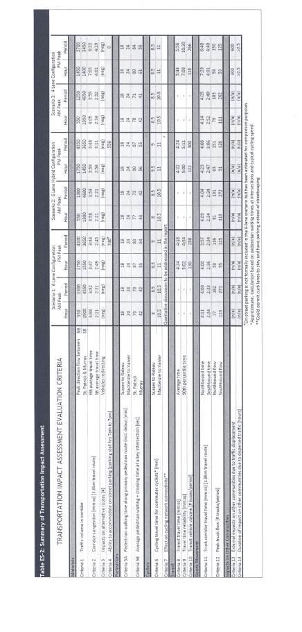
Traffic Impact Assessment
Motorists
Four main criteria were used to assess motorist transportation
impacts relating to ability to accommodate traffic, corridor congestion,
neighbourhood infiltration and availability of parking.
Traffic volumes - Traffic volume in the corridor measured
directional flow (i.e. northbound and southbound) for the AM and PM peaks for
two intervals: one-hour and 2.5-hour peak periods. Volumes were fairly consistent across all three scenarios for the
AM period (i.e., 1300 and 4600 vehicle range for southbound flow in peak hour
and period). The Six-lane and Six-lane
Hybrid configurations exhibited similar traffic flow characteristics in PM peak
(i.e. 1750 and 4300 vehicle range for northbound flow in peak hour and
period). The Four-lane Configuration
exhibited a significant reduction (approximately 20%) in the number of vehicles
able to flow through the corridor in the PM peak hour and period (i.e. 1400 and
3450 range for northbound flow in peak hour and period).
Corridor congestion - In terms of corridor congestion (which
measures the average northbound and southbound travel time in minutes), the
northbound AM peak travel times were consistent across all scenarios. The Four-lane Configuration saw increased
congestion for northbound and southbound PM peak periods, with an estimated
increase in travel time of approximately 3.0 minutes for northbound direction
(from roughly 4 minutes in scenarios 1 and 2 to 7 minutes in scenario 3) and
approximately 1.5 minutes for southbound direction (from roughly 2.5 minutes in
scenarios 1 and 2 to 4 minutes in scenario 3).
Impact on alternative routes - This criterion attempts to measure
the number of vehicles that might reroute to other streets (i.e. neighbourhood
infiltration) to assess the potential impact on adjacent neighbourhoods. Due to software limitations, it was not
possible to quantify this through traffic modelling. It was only possible to
estimate the level of traffic that would no longer be processed in the study
corridor but not to determine where traffic was being diverted to. The traffic on King Edward Avenue could
largely be presumed to be regional travellers attempting to reach destinations
beyond the study area. As such,
neighbourhood infiltration could be considered to be negligible under each of
the three scenarios. Anecdotal information from Transportation Staff suggest
that there may be traffic cutting-through other areas in the broader network on
roads including Dalhousie Street, Sussex Drive through Rockcliffe Park, and
Crichton Street.
Accommodation of on-street parking - The ability to accommodate
on-street parking was considered under each scenario, being mindful of peak
direction parking restrictions that could likely be enforced. For each scenario, the potential availability
of parking stalls over the course of a 12-hour period (7 am-7 pm) was measured
to determine total “parking stall hours” available. Scenario 1 has the ability to accommodate 740 parking space hours
and Scenario 2 has the ability to accommodate 556 parking space hours. Scenario 3 is not able to accommodate any
parking space hours under the configuration assumed; however, if curb lanes
were maintained in this scenario, on-street parking in certain locations could
be included as a trade-off to wider boulevards and streetscaping.
Pedestrians
Two main criteria were used to measure impacts on pedestrians -
walking time along a primary pedestrian route and pedestrian waiting and
crossing time at a key intersection.
Pedestrian walking time along two pedestrian routes was measured in
minutes to estimate the time it might take pedestrians to walk from Sussex
Drive to Rideau Street (north to south) and from Mackenzie Avenue to Vanier
Parkway (west to east). Route distances were approximately 2 km from Sussex Drive
to Rideau Street and approximately 2.5 km from Mackenzie Avenue to Vanier
Parkway. The results did not vary
significantly between the three scenarios.
Pedestrian waiting time at a key intersection measured the amount of
time in seconds it took pedestrians to cross St. Patrick and Murray Streets,
including pedestrian wait time at the intersection before being granted right
of way. For both “pedestrian routes”,
the total pedestrian wait and crossing times were in the same range across all
three scenarios. Crossing times for the
Four-lane Configuration were the shortest because of the narrower intersection
crossing distance, however due to traffic signal timing the wait times between
crossing opportunities offset this benefit.
Cyclists
Two main criteria were used to assess the impact of the lane
reduction scenarios on cyclists - cycling time for commuter cyclists and effect
on cycling network connectivity.
Results indicate that there is no distinct difference for cycling
travel time across scenarios during the AM peak period. In the PM period,
cyclists travelling in the north-south direction benefit from a modified signal
timing (i.e., reduced east-west pedestrian crossing distance), incurring
0.5 to 1.0 minute less signal delay at the St. Patrick Street and Murray
Street intersections with King Edward.
There is little effect on cycling network connectivity due to
changes in configurations since King Edward Avenue is not part of the
Ottawa Cycling Plan (OCP) network, however there is potential for reallocation
of road space within the Four-lane Configuration (Scenario 3), which could
enable the creation of cycling lanes on King Edward Avenue. If this occurred, it would augment the OCP
Spine network and improve connectivity.
Transit
To assess the effectiveness of transit in the four scenarios, three
main criteria were used - transit travel time, travel time reliability, and
transit vehicle volume.
Transit travel time measured the average time it took Société des
transports de l’Outaouais (STO) buses to travel the corridor from a starting
point on the MacDonald-Cartier Bridge to their route starting point at the
intersection of Rideau Street and King Edward Avenue. Transit travel time for the two six lane configurations
(Scenarios 1 and 2) was consistent, and the Four-lane Configuration (Scenario
3) exhibited an increase of approximately 1.5 minutes of travel time per bus
for both the PM peak hour and the peak period.
This was an increase from 4:20 minutes to 5:45 minutes of travel time.
In comparing the Four-lane Configuration (Scenario 3) with the other
scenarios, this increase in travel time for transit vehicles is significant
given that approximately 120 buses per hour start their routes at the corner of
Rideau Street and King Edward Avenue.
Many of these buses are “deadheading” (i.e. travelling without
passengers) between routes. A 1.5 minute delay along King Edward Avenue means a
delay in arriving at Rideau Street at the very start of their route which then
results in a delay for passengers and the potential need to increase the fleet
size in order to compensate for the system-wide effect of this delay or travel
time variability.
Transit time reliability was measured using the 90th percentile
transit travel time, which is a common measurement used in the transit industry
to provide an indication of how well transit vehicles are adhering to a
schedule.
The 90th percentile time for the Six lane Configurations (Scenarios
1 and 2) was comparable to their average transit travel time. This indicates
that it is less likely that additional time would have to be added to bus
schedules under these scenarios.
In the Four-lane Configuration (Scenario 3), the 90th percentile
time was over 10 minutes for the PM peak period. This means that 90 percent of
all buses would complete their route in 10 minutes or less. As such, the STO
may require that additional time be added to all buses scheduled within the PM
peak period.
Transit vehicle volume measured the number of buses that were able
to travel their route in the PM peak hour and peak period. It measured how well transit vehicles were
able to negotiate the corridor under congested conditions.
In the peak hour, 120 buses are expected to flow through the corridor based on STO scheduling. At least this number of buses can get through the corridor in both Scenario 1 and Scenario 2 (130 and 122 respectively). The four-lane configuration only allows 118 buses (2 less than the number of buses scheduled) to complete their route in the modelling software.. In the peak period, the number of buses processed within the corridor was expected to be 300 which dropped to 266 for Scenario 3 as compared to 288 and 300 respectively for Scenarios 1 and 2.
Goods Movement
Two main criteria were used to assess the impact of reducing lanes
on goods movement - truck corridor travel time (measured as the minutes of time
per truck through the corridor in northbound and southbound directions) and
peak truck flow (measured as the number of trucks per period).
In terms of truck corridor travel time, travel times for the AM peak
hour and peak period were consistent across all scenarios with an average
northbound time of approximately 4 minutes and an average southbound time of
approximately 2.5 minutes. Truck travel
times for the PM peak hour and peak period were consistent across Scenario 1
and 2, but were higher for Scenario 3 at roughly 7 minutes and 4 minutes for
the southbound and northbound directions, respectively.
Results for the Peak truck flow criterion were fairly consistent across
all scenarios in the northbound and southbound direction for all time periods,
and no discernable differences were noted.
Safety Considerations
Pedestrian exposure to traffic while crossing an intersection was
assessed using two criteria - time that pedestrians would be exposed to traffic
while crossing King Edward Avenue, based on average walking speed, and
estimated operating speed of vehicles, southbound and northbound during the
peak period.
Under both the Six-lane and Six-lane Hybrid Configurations
(Scenarios 1 and 2), pedestrian exposure to traffic remain essentially the
same. Under the Four-lane Configuration
(Scenario 3) the width of King Edward Avenue is reduced by two lanes and as
such, the pedestrian crossing time in the east-west direction of crossing would
be reduced by approximately 4 metres (one lane equivalent). For the average pedestrian, this translates
to a reduction of walking time or reduced “exposure to traffic” of 3 seconds
(i.e. total of 37 seconds to cross vs. 40 seconds under the other two
scenarios).
In terms of estimated operating speeds, the VISSIM traffic
simulation predicts that Scenario 3 will have the lowest operating speeds with
a weighted average of 39 km/h (with speeds in the range of 24 to 48 kilometres
per hour). Scenario 1 will experience operating speeds in the range of 32 to 48
kilometres per hour (km/h) with a weighted average of 42 km/h. Scenario 2 will experience speeds in the
range of 31 to 48 kilometres per hour (km/h) with a weighted average of 41
km/h. It should be noted that these speeds are predicted during the peak time
and that traffic flow in the corridor is expected to be different during
off-peak times (i.e. free flowing traffic).
Conclusions and Next
Steps
The KEA Lane Reduction Study was initiated to determine whether
alternative roadway configurations would be feasible for King Edward Avenue and
to assess the potential community and transportation impacts. The study's
comparative assessment of the three lane reduction scenarios provide a firm
understanding of the relative differences between each, and indicates that all
three scenarios have sufficient merit to be considered further.
It is recommended that Phase 2 of the study be undertaken to complete a proper evaluation of the impacts, consultation with a broad range of stakeholders, and to provide a final recommendation regarding a lane reduction, if appropriate, to Transportation Committee by the end of 2009. The work to be undertaken in Phase 2 includes the creation of an evaluation framework to weight each of the assessment criteria and costing of the capital and operating costs of the lane reductions. Consultation with a broader set of stakeholders would also be carried out to ensure that their views are taken into consideration. It is anticipated that Phase 2 will take approximately 4 months.
CONSULTATION
Members of the King Edward Avenue Task Force have
been an integral part of the KEA Lane Reduction Study Team. Members of the Task Force have played an
important role with staff and the consultants in defining the project,
designing the analytical framework, and reviewing outputs. To date,
consultation activities have been focussed on members of the King Edward Avenue
Task Force and Lowertown Community Association. Councillor Georges Bédard, the
Ward Councillor for the area, and his staff have also been consulted regularly.
Phase 2, if approved, would see consultation activities expanded to include in addition to the Sandy Hill and Lowertown communities, other stakeholders that have an interest in King Edward Avenue. This includes, for example, adjacent Business Improvement Areas (BIAs), various agencies, transit operators, commuters, and the public-at-large.
LEGAL/RISK MANAGEMENT IMPLICATIONS
There are no legal/risk management impediments to the implementation of this Report's recommendations.
FINANCIAL IMPLICATIONS
Funds are available in Internal Order No. 904920 - King Edward Avenue Lane Reduction Study and the 2009 Operating Budget, Cost Centre 112112 - Economic Development, to fund Phase II of the study, which is estimated to cost $45K.
SUPPORTING DOCUMENTATION
Document 1 King Edward
Avenue Lane Reduction Impact Study (on file with the City Clerk)
Document 2 Key Intersection Cross Sections for Each
Scenario
Document 3 Summary of Community and Transportation Impact Analysis by Scenario
DISPOSITION
Upon approval, Community Sustainability staff will work with the King Edward Avenue Study Team to initiate Phase 2 of the KEA Lane Reduction Study as described in this report.
Key Intersection Cross Sections for Each Scenario DOCUMENT 2
SUMMARY OF COMMUNITY AND TRANSPORTATION
IMPACT ANALYSIS BY SCENARIO DOCUMENT
3