Report
to/Rapport au :
Transportation Committee
Comité des transports
and Council / et au Conseil
30 June 2008 / le 30 juin 2008
Submitted
by/Soumis par: Councillor/Conseiller Rob Jellett
Contact
Person/Personne ressource : Councillor/Conseiller Rob Jellett, Cumberland
613-580-2489,
Rob.Jellett@ottawa.ca
|
Ref N°:
ACS2008-CCS-TRC-0014 |
|
SUBJECT: |
SHOPPERS DRUG MART COMMERCIAL/RETAIL DEVELOPMENT (Tenth Line Road / Blackburn Hamlet Bypass Extension) |
|
|
|
|
OBJET : |
Aménagement commercial/de détail d’un
shoppers drug mart (chemin tenth line/prolongation de la rocade de blackburn
hamlet) |
REPORT RECOMMENDATION
That the Transportation
Committee recommend Council approve provision of a partial-movement site access
to/from the proposed widened Blackburn Hamlet Bypass Extension (BHBPE) (from
2-lanes to 4-lanes) subject to future on-going monitoring of traffic
operations. The requested movements are
right-in, right-out and inbound left turns.
Outbound left-turn movements would be prohibited.
RECOMMANDATION DU RAPPORT
Que le Comité des
transports recommande au Conseil d’approuver la mise en place d’un accès, qui
serait assujetti au contrôle continu à venir de la circulation, à la
prolongation proposée de la rocade élargie (de deux voies à quatre voies) de
Blackburn Hamlet et depuis cette dernière, avec mouvements de circulation
partiels, ce qui entraînerait l’aménagement d’un ilôt tourne-à-droite et d’une
voie de virage à gauche entrante. Les virages à gauche sortants seraient
interdits.
BACKGROUND
Pursuant to Section 77 (12) of the Procedure By-law, this report was requested to be placed on an upcoming Transportation Committee agenda. Originally, it was requested to go to the Planning and Environment Committee, but given that the report deals with a roadway modification and in consultation with staff, it was agreed that it would be appropriate to have the matter considered by the Transportation Committee.
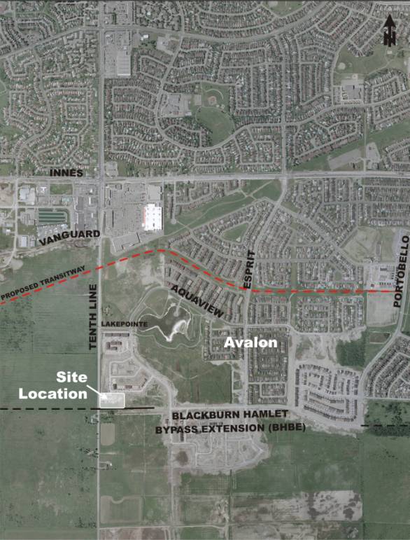
The subject site is situated in the northeast
quadrant of the Tenth Line/Blackburn Hamlet Bypass Extension (BHBE) in the
Ottawa community of Orléans. Shoppers
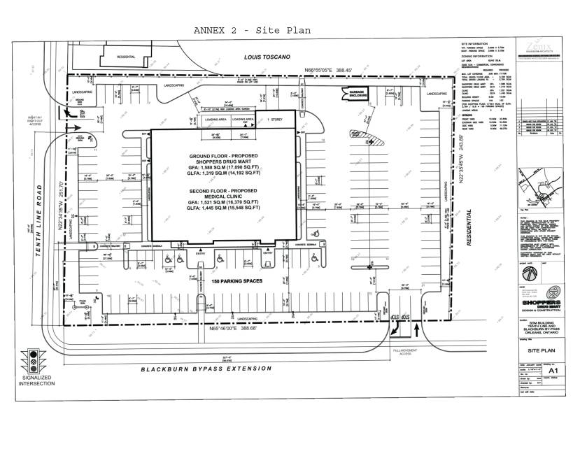
Drug Mart (SDM) is proposing to develop a two-storey retail store and medical
facility, comprised of 1,588 m2 GFA retail pharmacy/drug store on
the ground-level and 1,521 m2 GFA medical offices on the upper
level.
Annex 1 and 2 illustrate site context and the
proposed site plan, respectively.
Both adjacent roads, namely Tenth Line Road
and BHBE, are currently two-lane roads and are planned ultimately as four-lane
divided arterials. Adjacent to the
site, Tenth Line Road is expected to be widened to four lanes by 2010 and BHBE
by 2015. Regarding site access/egress,
a right-in/right-out site connection is proposed to Tenth Line Road, and a
right-in/right-out/left-in connection is proposed to the BHBE. The left-in movement from the BHBE is
considered key to the site’s success as a community health provider and retail
establishment given its relatively central location in the Orléans south growth
area. It is recognized that a balance
needs to be found in providing site access for sustainable new development and
accommodating future arterial road traffic in a safe and efficient manner.
As part of the Site Plan Application, a
Transportation Impact Assessment (TIA) consistent with City of Ottawa
Guidelines was prepared in March 2008.
Public Works and Services have reviewed the study and support the full
movement connection to the BHBE prior to its widening to four lanes
subject to:
- provision of auxiliary turn lanes where necessary to ensure safe operations are constructed; and
- an understanding that left-turn movements will be restricted once the BHBE is widened to four lanes or operation and/or safety concerns arise (as determined by the City).
Public Works and Services does not support left-in access or left-out
access to the BHBE after its widening.
The comments received on the TIA from staff did indicate that the
developer is permitted to provide an assessment and justification to
Transportation Committee and Council seeking approval for the desired road
feature, which is provided next.
DISCUSSION
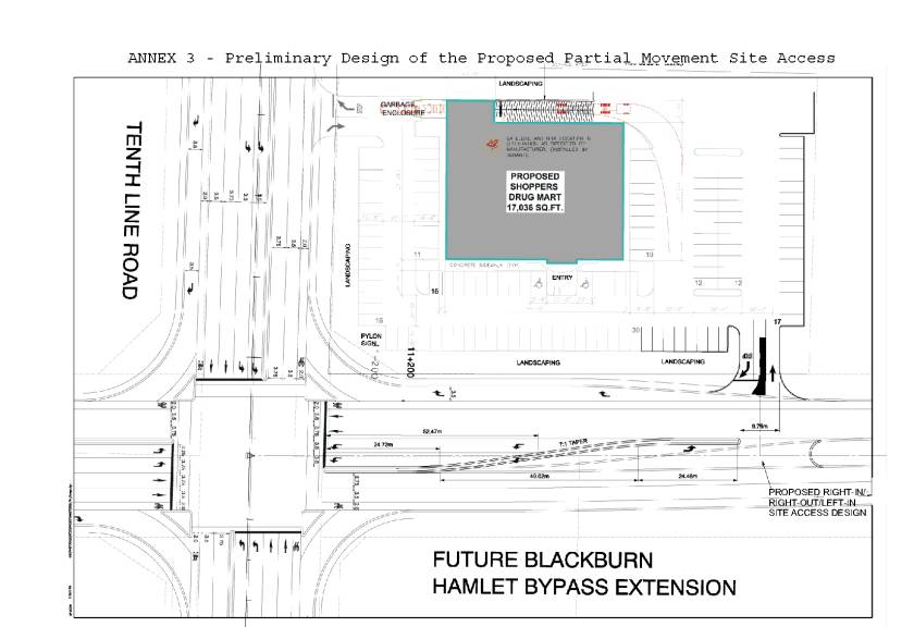
Included as Annex 3 is the proposed design for the right-in/right-out/left-in access to the site from BHBE. It is located approximately 100 m east of the Tenth Line/BHBE intersection. The preliminary design features an auxiliary eastbound left-turn lane into the SDM site and two auxiliary westbound left-turn lanes approaching the Tenth Line Road intersection. Based on volume projections, there is sufficient storage provided in both sets of left-turn lanes to avoid any queuing and turn lane impacts.
As area traffic volumes increase, it is anticipated that the westbound queue forming at the Tenth Line/BHBE intersection will eventually extend beyond the approximate 100 m spacing available between the intersection stop bar and SDM site access driveway connection to the east. This scenario can be considered unsafe given certain design configurations, although the proposed design and overall site context are believed to minimize the typical safety concerns. Specifically, motorists seeking to complete left-turns into the SDM site will be required to find an acceptable gap in only two westbound streams of traffic as the auxiliary turn lanes develop downstream of the driveway connection. When these lanes are queued, equal utilization is expected given that two through lanes are maintained west of Tenth Line Road.
A queuing analysis conducted by the proponent’s consultant, determined that:
- the subject queue is not likely to materialize for many years;
- when it does materialize, the queue will block the site driveway to BHBE for a small portion of the peak hour;
- the projected eastbound left-turn site traffic at the subject location is estimated at one vehicle every 1 to 2 minutes;
- as the subject queue will only block the site entrance for a small portion of the peak hour and as the subject left-turn volumes are very low, there will be only a few occurrences during peak periods when the queue will actually block an inbound left-turning vehicle;
- when this occurs, the subject vehicle (which is positioned with a left-turn lane) can safely wait a number of seconds until the queue clears; and
- during the balance of the day, there will be no conflict between the eastbound left-turn movement and the westbound queue.
Based on the foregoing, it is proposed that it is appropriate to permit the subject eastbound left-turn movement, with the option to close it at some future date should monitoring reveal it results in “out of the ordinary” safety-related issues.
CONSULTATION
A community meeting was held on the evening of 30 April 2008 at the Ray Friel Centre where the proposed Site Plan was presented. No concerns regarding traffic operations and/or safety were voiced by the members of the public at this meeting.
Public Works & Services - Traffic and Parking
Operations
Public Works and Services (PWS) (Traffic and Parking Operations Branch) have been involved with the associated site plan application from a traffic impact perspective. Through pre consultation meetings and a review of the application’s Traffic Impact Assessment report, staff have assessed the site operation and impact as it relates to the adjacent arterial road network.
As identified earlier in this report PWS does not support a left-turn movement into or out of the site from Blackburn Hamlet Bypass Extension once expanded (median divided four lane cross section).
This decision was reached based on
compliance with the City’s road design standards, the application of good
engineering design practices for the safe operation of public roads, and in
support of the Council approved design concept identified in the Blackburn
Hamlet Bypass Extension EA.
Approximately 50% of Ottawa’s 15,300
collisions in 2007 occurred at intersections with the majority of those at
signalized arterial/arterial intersections.
These figures highlight the importance of safety and safe design when
designing intersections and the surrounding area influenced by them.
Minimizing conflict points and driver
workload are the fundament issues. This
is particularly important for the busiest intersections, arterial/arterial
crossings such as the subject intersection, where speeds and volumes are at
their highest levels and there is a greater presence of pedestrians, cyclists
and heavy vehicles. Driver workload and
associated driver expectation is of greatest concern in an intersection’s “area
of influence”. When entering into a
multi-lane intersection the length of the turning lanes and the queue lengths
generated by the traffic signal operation typically set the outer boundaries of
this area. It is in this area that the
demand on the driver’s attention (driver work load) is greatest as frequent
decisions are required to negotiate safe passage. Providing an area where there are no conflicting movements (i.e.
left turn vehicles crossing through traffic) is essential. Where left-turns are permitted it is
critical that gaps in opposing traffic are adequate, acceptable and
left-turning vehicles are not making turns through queued traffic (a recognized
collision concern in a number of Ottawa locations). The proposed left-turn into the site is contrary to both these
design factors. Although traffic
forecasts noted previously in this report indicate that queues will be brief,
the forecasts are provided for the site’s design horizon of 2015. Growth in the opposing through movement
beyond that time period will see the queues extend for longer periods of time.
In terms of driver expectation, good design
practices would suggest that design elements should not be a surprise to
motorists. Inclusion of a left-turn at
the proposed location and within the City’s 120 m minimum guideline for
consideration of full movement access would violate driver expectation with an
unexpected median break. Where turns
are made through queues, existing problem locations exist in Ottawa where queue
lengths are uneven and courteous drivers in the oncoming near lane provide a
gap to allow left-turning vehicles to proceed, only to set up a potential
collision condition with vehicles approaching in the second lane. This report previously states the queues in
the approach lanes will be balanced but there is no way of ensuring this will
happen at all times.
Minimizing the driver work load and vehicle conflict points in an intersection’s “area of influence” has been a key factor in reducing collisions in and around Ottawa intersections over the years, and part of the reason the City of Ottawa has one of the lowest collision rates amongst large urban areas and the lowest auto insurance rates where non public insurance programs exist.
Design practices supporting safe operations
through driver work load and vehicle conflict management include the
restriction of site access movement, near major intersections, from full movement
to restricted movement. To accomplish
this the standard practice is to use curb deflection and/or fixed medians that
extend beyond the intersection’s turning lanes and/or actual or anticipated
queue lengths. This is a supported
practice by the Transportation Association of Canada (TAC) Geometric Design
Guide for Canadian Roads and the City’s standard design practice. Examples of this would include neighbouring
Shoppers Drug Marts on Innes Road that do not have direct uncontrolled full
movement access to their sites.
The design as proposed by this report provides for a median break within the area of influence as defined by the queue lengths associated with this intersection. As previously identified in this report the consultant calculated BHBE queues for the westbound direction would extend beyond Shopper Drug Mart’s proposed site access. Providing the left-turn movement in this situation would violate design consistency, driver expectation and proper engineering design practice for the safe and efficient operation of this road and is therefore not recommended.
Although the proposed design is supported by a monitoring task to allow for the removal or prohibition of the desired left-turn movement in the future should it be deemed unsafe, it has been the City’s practice to prohibit collisions from happening through design where experience tells us they are likely to occur as opposed to facilitating collision occurrences and responding after the fact.
Planning, Transit & the Environment - Infrastructure
Approvals
An application for Site Plan Control Approval was filed March 18, 2008
for a retail store and second floor medical/dental clinic. Notice of the application and proposal have
been available for viewing on the City website since mid-April and signs have
been posted on the site. The
application was circulated to technical agencies, the Ward Councillor and
community groups for comments. A
Community Information and Comment Session was held April 30th with
notice being sent out to property owners within 120 metres of the site. A review of the second submission of the
proposal has been completed and other than the request for the left-turn in
bound off of the By-pass there are only a few minor issues to be addressed
prior to site plan approval.
FINANCIAL IMPLICATIONS
The developer will be responsible for any costs related to providing the proposed site driveway connection to the BHBPE and removal of any restricted movements should they be deemed unsafe at any future time.
SUPPORTING DOCUMENTATION
Annex 1 - Site Context
Annex 2 - Site Plan
Annex 3 - Preliminary Design of Proposed Full Movement Site Access
DISPOSITION
Staff in PTE will follow through with the decision taken by Committee and Council as part of the Site Plan Control Approval process and in line with the requirements of the City's Notice Bylaw for road modifications.
Site Context ANNEX
1