Report to/Rapport au :
Comité des transports
and Council / et au Conseil
26 October 2005 / le 26 octobre 2005
Submitted by/Soumis par :
R.G. Hewitt, Acting Deputy City Manager/Directeur municipal adjoint
intérimaire,
Public
Works and Services/Services et Travaux publics
Contact Person/Personne ressource : Michael J.
Flainek, P. Eng., Director/Directeur
Traffic & Parking Operations/Circulation et
stationnement
(613) 580-2424 x 26882, Michael.Flainek@ottawa.ca
|
SUBJECT: |
|
|
|
|
|
OBJET : |
REPORT RECOMMENDATIONS
That Transportation Committee recommend Council:
1. Approve the Truck Route Designation Policy as outlined in
this report (Document 1);
2. Receive
the 2005 Truck Routes maps for information (Document 2); and,
3. Approve
the installation of permissive truck route signing for those locations where
signs are currently missing
on an "as-required" basis.
RECOMMANDATIONS DU RAPPORT
Le Comité des transports recommande que le Conseil municipal :
1.
Approuve la politique de désignation des
routes pour camions telle qu’énoncée dans ce rapport (Document 1) ;
2.
Prenne connaissance des itinéraires des
camions (Document 2); et,
3.
Approuver l’installation d’une signalisation
autorisant la circulation de camions dans les emplacements où cette
signalisation est absente, selon les besoins.
EXECUTIVE SUMMARY
Assumptions and Analysis
Following amalgamation, it was identified that there was a need to
harmonize City policies. This included
the designation of roads under the jurisdiction of the City of Ottawa that will
be signed as truck routes and identified for that purpose in the Traffic and
Parking By-law. These roads form the
City's Truck Route System.
The basis for the City of Ottawa Truck Route Designation Policy, attached as Document 1, resulted from the work conducted by the consultant (Totten Sims Hubicki Associates) retained to develop and recommend a harmonized Truck Route Policy. The existing and recommended Truck Route System reflects only those truck routes designated by the former Regional Municipality of Ottawa-Carleton and constituent municipalities, including those which have been introduced since amalgamation by virtue of new arterial road construction. As all of those changes were previously approved by Regional Council or a Council of a former constituent municipality, or, City Council since 1 January 2001, individual Ward Councillors were not specifically consulted in the preparation of this report.
Financial Implications
The request for the installation of
permissive signage corresponds with provisions of the City of Ottawa Traffic
and Parking By-law and the Ontario Highway Traffic Act, and will result in
meeting the requirement of the "Ontario Traffic Manual, Book 5 -
Regulatory Signs".
While a detailed city-wide inspection has not been conducted to determine the exact number of new signs required to fully comply with those provisions, it is acknowledged that there are gaps in Truck Route signage particularly in the rural area. These deficiencies are being addressed as they come to light and are being charged to the Traffic Operations Sign Maintenance Operating Budget. As this approach appears to be adequate in coping with that need, it is anticipated that unless there are major changes to the Truck Route Network or in legislated requirements pertaining to Truck Route signage, this trend will continue.
Public Consultation/Input
Consultation with a wide variety of groups was undertaken during the Study. Among others, comments were received from the National Capital Commission, the Ontario Trucking Association, the former City Transportation Advisory Committee, the City's Agriculture and Rural Affairs Committee, and City staff.
As the resultant Truck Route System
reflects only those truck routes designated by the former Regional Municipality
of Ottawa-Carleton and constituent municipalities, including those which have
been introduced since amalgamation by virtue of new arterial road construction,
individual Ward Councillors were not specifically consulted in the preparation
of this report as all of those changes were previously approved by Region
Council or a Council of a former constituent municipality, or, City Council
since 1 January 2001.
RÉSUMÉ
Hypothèses
et analyse
À la suite de la fusion, on a déterminé qu'il
était nécessaire d'harmoniser les politiques de la Ville. Cela consistait notamment à désigner des
routes relevant de la compétence de la Ville d'Ottawa comme itinéraires pour
camions, de les doter de panneaux et de les identifier à cette fin dans le Règlement sur la circulation et le
stationnement. Ces routes
forment le Système d'itinéraires pour
les poids lourds de la Ville.
La base de la Politique de désignation des
itinéraires pour camions de la Ville d'Ottawa, ci-jointe comme Document 1,
découle des travaux accomplis par le consultant (Totten Sims Hubicki
Associates) qui a été chargé d'élaborer et de recommander une politique
harmonisée de désignation des itinéraires pour camions. Le Système
d'itinéraires pour les poids lourds actuel et recommandé ne reflète que les
itinéraires pour camions désignés par l'ancienne Municipalité régionale
d'Ottawa-Carleton et les municipalités constitutives, y compris ceux établis
depuis la fusion en raison de la construction de nouvelles routes de
dégagement. Puisque le Conseil régional, ou le Conseil d’une ancienne
municipalité constitutive ou le Conseil municipal depuis le 1er
janvier 2001 avaient déjà approuvé tous ces changements, les conseillers de
chaque quartier n’ont pas été particulièrement consultés durant la préparation
du présent rapport.
Répercussions
financières
La
demande d’installation de panneaux d’autorisation est conforme aux stipulations
du Règlement sur la circulation et le stationnement de la Ville d’Ottawa et du
Code de la route de l’Ontario, et répondra également aux exigences du
« Manuel du Code de la route de l’Ontario, livret 5 – Panneau de
signalisation ».
Bien qu’on n’ait pas mené une inspection approfondie à la grandeur de la ville afin de déterminer le nombre exact de nouveaux panneaux à installer pour satisfaire pleinement à ces stipulations, on reconnaît que la signalisation des routes pour camions est déficiente, surtout en milieu rural. On installe des panneaux au fur et à mesure que le besoin est relevé et on les facture au budget de fonctionnement du service d’entretien des panneaux de la Circulation routière. Comme cette approche semble combler ce besoin de manière satisfaisante, on prévoit que cette tendance se maintiendra, à moins que d’importantes modifications ne soient apportées au réseau routier pour camions ou aux exigences législatives liées à la signalisation des routes pour camions.
Consultation – rétroaction du
public
Cette étude a fait l’objet d’une consultation auprès de divers groupes d’intérêt présentant des points de vue variés. Entre autres, des commentaires nous sont parvenus de la Commission de la capitale nationale et des membres de l’Association de camionnage de l’Ontario, de l’ancien Comité consultatif de transport, du Comité consultatif sur l’agriculture et les affaires rurales et du personnel de la ville.
Puisque le réseau d’itinéraires pour
camions subséquent ne reflète que les itinéraires pour camions désignés par la
Municipalité régionale d’Ottawa-Carleton et les municipalités constitutives, y
compris ceux qui ont été établis depuis la fusion en raison de la construction
de nouvelles routes de dégagement, et que le Conseil
régional, ou le Conseil d’une ancienne municipalité constitutive ou le Conseil
municipal depuis le 1er janvier 2001 avaient déjà approuvé tous ces
changements, les conseillers
de chaque quartier n’ont pas été particulièrement consultés durant la
préparation du présent rapport.
BACKGROUND
At Council’s direction, a set of projects were
undertaken to harmonize City policies following amalgamation. One of these was the harmonization of the
Truck Route System to designate roads under the jurisdiction of the City of
Ottawa, to be signed as truck routes and identified for that purpose in the
Traffic and Parking By-law. In this
By-law, “heavy trucks” are defined as any motor vehicle having a carrying capacity
in excess of one tonne and/or having a gross weight in excess of four and
one-half tonnes. Public transit
vehicles travelling on transit routes, ambulances and school vehicles, are not
considered “heavy trucks” for the purposes of the Traffic and Parking By-law.
The City retained Totten Sims Hubicki Associates to develop and
recommend a harmonized City of Ottawa Truck Route Designation Policy. The consultant’s report, entitled "Truck
Route Designation Policy", provided the basis for the City of Ottawa Truck Route Designation Policy,
attached as Document 1.
The existing Truck Route System evolved over many years and largely
confirmed the result of a truck route study undertaken in the early 1980’s by
the former Regional Municipality of Ottawa-
Carleton. The proposed harmonized Truck Route System is consistent with the truck routes designated by the former Region of Ottawa-Carleton and constituent municipalities which have been in effect for a number of years.
DISCUSSION
The objectives and criteria used during the
development of the former Region’s Truck Route Policy are still relevant and
were used as the foundation for the development of an updated City of Ottawa
Truck Route Designation Policy, attached as Document 1.
Roadways designated as a result of the City of Ottawa Truck Route
Designation Policy are identified with permissive signage in accordance with
the provisions of the City of Ottawa Traffic and Parking By-law and the Ontario
Highway Traffic Act and are to meet the requirements of the Ontario Traffic
Manual, Book 5 - Regulatory Signs.
CONSULTATION
Internal and external contacts, representing a wide range of interests and perspectives, were made during the Study. In addition to City staff, comments were received from the National Capital Commission and members of the Ontario Trucking Association, the former Transportation Advisory Committee and the Agriculture and Rural Affairs Committee.
Improved public awareness is essential to the understanding of and adherence to the City of Ottawa Truck Route Designation Policy. Based on the consultation undertaken, education was identified as being of key importance. Elements may include placement of display maps and handout maps at truck stops, coordination with centres where truckers are trained, installation of permissive truck route signs where currently missing, and making the truck route map easier to find on the City’s web site. Public education is also required to increase understanding of the provisions the Traffic and Parking By-law that permit deviations from the Truck Route System, such as for successive deliveries off the truck routes.
The existing and recommended Truck Route System reflects only those truck routes designated by the former Regional Municipality of Ottawa-Carleton and constituent municipalities, including those which have been introduced since amalgamation by virtue of new arterial road construction. As all of those changes were previously approved by Regional Council or a Council of a former constituent municipality, or, City Council since 1 January 2001, individual Ward Councillors were not specifically consulted in the prepartion of this report.
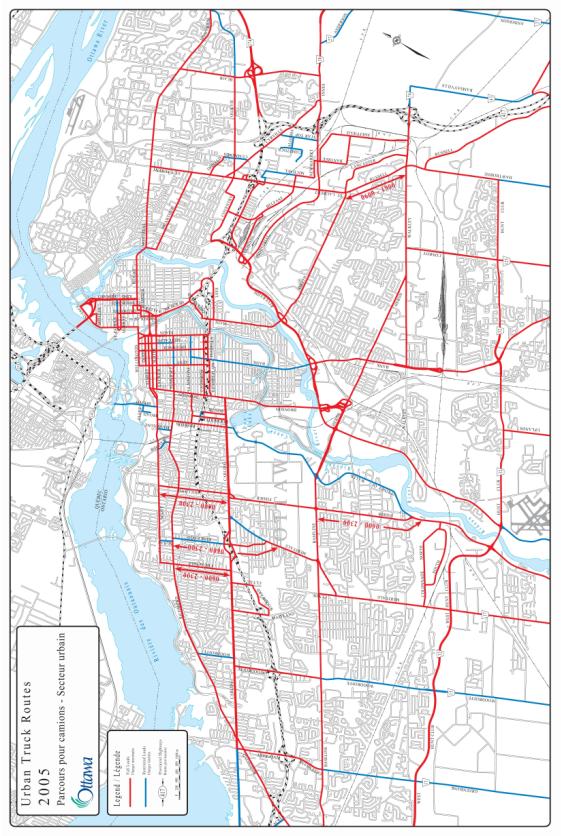
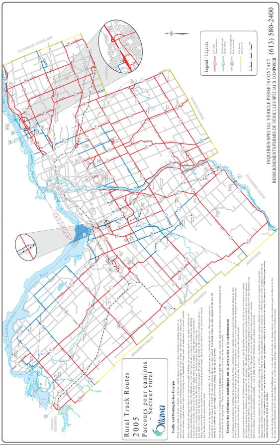
The 2005 Urban and Rural Truck Routes Maps, attached as Document 2, reflect the harmonized policy as discussed. Document 3 provides details of further required changes to the maps and the Traffic and Parking By-law in accordance with the City of Ottawa Truck Route Designation Policy. It is stressed that these amendments represent housekeeping items only as all were previously approved by the former Regional Council, former Municipal Councils, or City Council since 1 January 2001.
Requests for revisions to the Truck Route System will follow the Policy
as attached including consultation with the affected Ward Councillor.
TRANSPORTATION
MASTER PLAN
The objectives and criteria for the designation of truck routes in the attached City of Ottawa Truck Route Designation Policy are consistent with the strategic directions of the City of Ottawa’s Official Plan and the Transportation Master Plan, as approved by City Council.
FINANCIAL
IMPLICATIONS
The request for
the installation of permissive signage corresponds with provisions of the City
of Ottawa Traffic and Parking By-law and the Ontario Highway Traffic Act, and
will result in meeting the requirement of the "Ontario Traffic Manual,
Book 5 - Regulatory Signs".
While a detailed city-wide inspection has not been conducted to determine the exact number of new signs required to fully comply with those provisions, it is acknowledged that there are gaps in Truck Route signage particularly in the rural area. These deficiencies are being addressed as they come to light and are being charged to the general sign maintenance element of the Operating Budget. As this approach appears to be adequate in coping with that need, it is anticipated that unless there are major changes to the Truck Route Network or in legislated requirements pertaining to Truck Route signage, this trend will continue.
SUPPORTING DOCUMENTATION
Document 1 City of
Ottawa Truck Route Designation Policy
Document 2 2005 Urban and
Rural Truck Routes Maps (2)
Document 3 Revisions
Required to the Current By-law Listing and Truck Route Map
DISPOSITION
Staff will prepare amendments to the Traffic and Parking By-law regarding truck route designations to reflect changes identified in Document 3 for implementation. It is stressed that these amendments represent housekeeping items only as all were previously approved by the former Regional and Municipal Councils or City Council since 1 January 2001.
In response to specific problems or issues, staff will proceed with installation of required permissive truck route designation signage, as needed.
Staff will continue efforts to improve public understanding and awareness of the City of Ottawa Truck Route Designation Policy by providing information to truckers and by working to enhance the ease by which the truck route maps and all associated regulations may be accessed through the City's web site.
DOCUMENT
1

|
Subject: Truck
Route Designation Policy
|
New: X Revised: |
Policy/Procedure
No. |
|
|
Source: Council Report
ACS2005-PWS-TRF-0002 |
Date: 6 July 2005 |
Page #: 1 |
No. of Pages : 2 |
Purpose The
purpose of this Policy is to establish the basis for designating roadways
under the jurisdiction of the City of Ottawa as Truck Routes. Objectives The
following objectives are to be used for the development and updates to the
Truck Route System: The
following criteria should be applied as guidelines, to assess existing and
proposed road links for their suitability as Truck Routes and to optimize
the Truck Route System: 1. System/Network Criteria: a.
identify a continuous truck route system
with easy access to and from provincial highways, freeways, major
through routes, and truck traffic generators and attractors; b. include sufficient network linkages to avoid
over-concentration of truck movements and congestion; c. identify routes with good traffic flow to minimize stop and
start occurrences; and, d. avoid high pedestrian corridors and areas with significant
traffic conflicts. 2. Physical Characteristics
Criteria: a. particularly in urban areas, where possible select 4-lane
roadways with 3.5 m lanes, adequate turning radii;
vertical clearance of 5.4 m; and maximum grade of 4%; and, b.
include only those linkages with pavement
and structures that are structurally adequate for truck traffic. 3. Environmental
Criteria: a. minimize impacts of truck traffic
(vibration, noise and emissions) on sensitive areas such as
residential neighbourhoods, hospitals, schools; b. avoid routes adjacent to heritage/weak
structures; and, c. avoid bisecting
communities/neighbourhoods.
Criteria


|
Subject: Truck Route Designation Policy
|
New: X Revised: |
Policy/Procedure
No. |
|
|
Source: Council Report
ACS2005-PWS-TRF-0002 |
Date: 6 July 2005 |
Page #: 2 |
No. of Pages : 2 |
0
The table below summarizes Truck Route Designation Guidelines. Road Class Land Use and Policy Plans City Freeway Arterial Major Collector/Collector Central Area Designate as Truck Route Designate selected arterials to provide necessary connectivity and
continuity while minimizing impacts on residential areas. Designate selected collectors to provide necessary connectivity
and continuity while minimizing impacts on residential streets. General Urban Area Generally designate as Truck Routes. Avoid residential arterials where reasonable. Rural Area Generally designate as Truck Routes. Employment and Enterprise Areas Designate as Truck Route Generally designate as Truck Routes. Generally designate as Truck Routes. Villages Designate as Truck Route Generally designate as Truck Routes. Avoid residential arterials where reasonable. Designate selected collectors to provide necessary connectivity
and continuity while minimizing impacts on residential roads. Review The Truck Route System should undergo a
comprehensive review regularly as part of the Transportation Master Plan
process. On an annual basis, the
Truck Route System should be updated based on current pavement/structure
condition and/or new construction, prior to the publication of the annual
map. Development plans should
consider the need for truck route linkages and ensure that these are
provided in accordance with the desirable criteria established. Signing Permissive signing, consistent with the City of
Ottawa Traffic and Parking By-law and Ontario Traffic Manual Book 5 –
Regulatory Signs, shall be placed on all truck routes. Prohibitive signage may be used at
problematic locations.
TRUCK ROUTE
DESIGNATION GUIDELINES
DOCUMENT 2
2005 URBAN AND RURAL TRUCK ROUTES
MAPS
DOCUMENT
3
REVISIONS REQUIRED TO THE CURRENT BY-LAW LISTING
AND TRUCK ROUTE MAP . THIS IS A HOUSEKEEPING REQUIREMENT ONLY
|
To be added to the Truck Route Map: |
|
·
Ages Drive between Hawthorne Road and Swansea Crescent ·
Blackwell Street between Bantree Street and Leeds Avenue ·
Bourassa Street between St. Laurent Boulevard and Gladwin Crescent ·
Commissioner Street between Wellington Street and Bronson Avenue ·
Gladwin Crescent between Lancaster Road and the easterly end of
Gladwin Crescent ·
Leeds Avenue between Blackwell Street and Sheffield Road ·
Legacy Road between Ages Road and Swansea Crescent ·
Stevenage Drive between the southerly end of Stevenage Drive and
Hawthorne Road ·
Swansea Crescent between the southerly end of Stevenage Drive and
Stevenage Drive |
|
|
|
To be added to the By-law listing: |
|
·
Ages Drive between Hawthorne Road and Swansea Crescent |
|
·
Blackwell Street between Bantree Street and Leeds Avenue |
|
·
Bourassa Street between St. Laurent Boulevard and Gladwin Crescent |
|
·
Cambrian Road from Richmond Road (Ottawa Road 59) to Moodie Drive
(Ottawa Road 11) |
|
·
Castlefrank Road from Highway 417 to Earl Grey Drive |
|
·
Colonnade Road North and South between Merivale Road and Prince of
Wales Drive ·
Frank Kenny Road between Innes Road (Ottawa Road 30) and Rockdale
Road (Ottawa Road 33) |
|
·
Gladwin Crescent between Lancaster Road and the easterly end of
Gladwin Crescent |
|
·
Leeds Avenue between Blackwell Street and Sheffield Road |
|
·
Legacy Road between Ages Road and Swansea Crescent |
|
·
McKenna Casey Drive from Moodie Drive (Ottawa Road 11) to Strandherd
Drive |
|
·
Richmond Road from Eagleson (Oottawa Road 49) to Fallowfield (Ottawa
Road 12) |
|
·
Riddell Road from Dunrobin Road (Ottawa Road 9) to Torwood Road |
|
·
Stevenage Drive between the southerly end of Stevenage Drive and
Hawthorne Road |
|
·
Swansea Crescent between the southerly end of Stevenage Drive and
Stevenage Drive |
|
·
Torwood Road from Riddell Road to Vances Side Road ·
Tremblay Road between St. Laurent Boulevard and Triole Street ·
Triole Street between Parisien Street and Tremblay Road |
|
·
Vances Side Road from Torwood Road to Dunrobin Road (Ottawa Road 9) |
|
To be corrected in the By-law listing: |
|
·
Revise the listing for Gladstone Avenue to read from Preston Street
to Bronson Avenue and from Kent Street to Elgin Street |
|
·
Revise permitted time for heavy vehicles on Russell Road between St.
Laurent Boulevard and Walkley Road to 6:00 a.m. to 7:00 p.m. |
|
·
Revise
Parisien Street between St. Laurent Boulevard and Marchand Street to read
between Triole Street and Marchand Street (Connection from St. Laurent no
longer exists) |
|
·
Delete the listing for Donald Street from Rideau River to Cummings
Avenue (covered in another listing) |
|
·
Revise road names “Road C” and “Road E”, RMOC in the area of St.
Laurent Boulevard and Highway 417.
Road C is Labelle Street and Road E is Lemieux Street |
|
·
Delete St. Laurent Boulevard between Russell Road and Walkley Road
(road not included in truck routes) |
|
·
Remove Walkley Road, City of Ottawa between Russell Road and
Sheffield Road (covered under the Walkley Road listing from Bank Street to
Ottawa Road 43) ·
Revise to read Ottawa Road 33 between Ottawa Road 8 and South limits
of the City of the City of Ottawa. |