Report to/Rapport au :
Transportation
Committee
Comité des transports
and Council / et au Conseil
21 October 2005 / le 21 obtobre 2005
Submitted by/Soumis par : Ned Lathrop, Deputy City Manager/Directeur
municipal adjoint,
Planning and Growth Management/Urbanisme et Gestion de la croissance
Contact
Person/Personne ressource : Peter Steacy, Program Manager - Transportation
Environmental Assessments
Planning, Environment and Infrastructure
Policy/Politiques d’urbanisme, d’environnement et d’infrastructure
(613) 580-2424 x, peter.steacy@ottawa.ca
|
|
Ref N°: ACS2005-PGM-POL-0060
|
|
SUBJECT:
|
NORTH-SOUTH
CORRIDOR LIGHT RAIL TRANSIT (LRT) PROJECT (RIDEAU CENTRE TO BARRHAVEN TOWN
CENTRE) ENVIRONMENTAL ASSESSMENT STUDY RECOMMENDATIONS ARISING FROM 15 JULY 2005 APPROVED COUNCIL MOTIONS
|
|
|
|
|
OBJET :
|
PROJET DE TRONÇON NORD-SUD DU TRANSPORT EN COMMUN PAR TRAIN LÉGER
(TTL) (DU CENTRE RIDEAU JUSQU’AU CENTRE-VILLE DE BARRHAVEN) ÉTUDE
D’ÉVALUATION ENVIRONNEMENTALE RECOMMANDATIONS DÉCOULANT DES RÉSOLUTIONS DU CONSEIL QUI ONT ÉTÉ APPROUVÉES LE
15 JUILLET 2005
|
REPORT RECOMMENDATIONS
That the Transportation Committee recommend Council:
1.
Receive the findings of the technical studies (Documents 1 and 2)
that were undertaken to respond to Council’s six resolutions approved at its 15
July 2005 meeting on the North-South Corridor LRT (Rideau Centre to Barrhaven)
Environmental Assessment Study;
2.
Approve the service design concept shown in Document 1 – Exhibit 3,
which will reduce the numbers of buses on Albert and Slater Streets, as the
future direction for the transit service plan to be implemented in the coming
four years;
3.
Approve that Transplan 2006 includes proposals for the initial
changes in this direction.
Specifically:
a.
the introduction of a new rapid transit 90-series bus route along
Innes Road in Orléans and Blackburn Hamlet;
b.
the extension of rapid transit Route 95 to the Marketplace
commercial core of Barrhaven; and,
c.
restructuring and improving the transit route network in the
Greenboro area.
4.
Include in the 2006 capital budget funding to:
a.
implement transit priority measures on Baseline/Heron corridor to
accommodate the new rapid transit 90-series E-W route;
b.
design a new Transitway station at Jeanne d’Arc Boulevard to be
built and completed by 2008;
c.
design improvements to the Eagleson Transitway Station to be built
and completed by 2008;
d.
initiate the procurement of a smartcard fare system for both bus and
light rail services to be implemented by 2008/9; and
e.
direct staff to incorporate the fleet and infrastructure
requirements to support the service design concept (Document 1 – Exhibit 3) in
the next revision of the Long Range Financial Plan;
5.
Introduce a process to monitor and report to Council on the traffic
conditions on Albert and Slater Streets as detailed within this report,
initially in 2010 after implementation of the LRT and thereafter at three year
intervals, and;
6.
Receive the Terms of Reference – Ottawa Downtown Underground Transit
Facility Study (Document 2 – Appendix B) and direct staff to use this document
to initiate the review of the need for a downtown tunnel in context of the
upcoming TMP and OP updates.
7.
Approve that staff enter into discussions with the University of
Ottawa to extend the North-South LRT corridor onto university property, and to
initiate a public-private partnership to develop an underground parking
facility, integrated light rail transit station and other uses on the proposed
site;
8.
Subject to the successful outcome of the discussions with the
University of Ottawa, approve the 300 metre extension of the North-South LRT
Corridor to the University of Ottawa in the vicinity of Stewart Street at a
cost of approximately $5.0M for the track extension and station;
9.
Subject to Recommendation 8, above, approve the plan for vehicles to
share the LRT lane on the Mackenzie King Bridge;
10.
Subject to Recommendation 8, above, direct staff to obtain EA
approval for the 300 metre extension of the LRT corridor to the University of
Ottawa and permit vehicle traffic on the Mackenzie King Bridge.
RECOMMANDATIONS DU RAPPORT
Que le Comité des transports recommande au
Conseil :
1.
De
demander à recevoir les conclusions des études techniques (documents 1 et
2) qu’on a menées pour répondre à six résolutions du Conseil approuvées lors de
sa réunion du 15 juillet qui portent sur l’étude d’évaluation
environnementale relative au projet de tronçon nord-sud du TTL (du Centre
Rideau jusqu’à Barrhaven).
2.
D’approuver
le concept d’aménagement du service présenté à l’annexe 3 du
document 1, qui permettra de réduire le nombre d’autobus qui circulent sur
les rues Albert et Slater, comme orientation future pour le plan lié au service
de transport en commun, qui sera mis en œuvre au cours des quatre prochaines
années.
3.
D’approuver
que le processus de consultation de Transplan 2006 comprenne des
propositions relatives aux premiers changements à apporter à cette orientation,
plus précisément :
a.
l’ajout
d’un nouveau circuit de transport rapide par autobus de la série 90 le
long du chemin Innes à Orléans et à Blackburn Hamlet;
b.
le
prolongement du circuit de transport rapide no 95 jusqu’au
noyau commercial de Barrhaven (Marketplace);
c.
la
réorganisation et l’amélioration du réseau de transport en commun dans le
secteur Greenboro.
4.
De
prévoir des fonds dans le budget d’immobilisations de 2006 pour faire ce qui
suit :
a.
mettre
en œuvre des mesures de priorité au transport en commun qui s’appliqueront au
tronçon Baseline-Heron pour le nouveau circuit express est-ouest de la
série 90;
b.
concevoir
une nouvelle station du Transitway sur le boulevard Jeanne-d’Arc, qui sera
aménagée et achevée d’ici 2008;
c.
élaborer
des améliorations pour la station Eagleson du Transitway, qui seront apportées
et achevées d’ici 2008;
d.
entamer
l’acquisition d’un système de perception des tarifs par carte à puce pour le
service d’autobus et le service de train léger, qui sera mis en place d’ici
2008 ou 2009;
e.
demander
au personnel d’intégrer les exigences relatives au parc automobile et à
l’infrastructure visant à appuyer le concept d’aménagement du service
(annexe 3 du document 1) dans la prochaine révision du Plan financier
à long terme.
5.
D’instaurer
une procédure visant à surveiller les conditions de circulation sur les rues
Albert et Slater et à présenter un compte rendu au Conseil à cet égard, tel que
précisé dans le rapport, d’abord en 2010, soit après la mise en place du
service de TTL et, par la suite, tous les trois ans.
6.
De
demander à recevoir le document intitulé Cadre de référence – Étude sur
les installations pour le transport en commun souterrain au centre-ville
d’Ottawa (annexe B du document 2) et de demander au personnel de
l’utiliser pour commencer à évaluer la nécessité d’aménager un tunnel
souterrain dans le contexte de la mise à jour prochaine du PDT et du PD.
7.
Approuver
l’amorce de discussions entre le personnel et l’Université d’Ottawa en vue du
prolongement du tronçon nord-sud du TTL sur les terrains de l’Université, et
établir un partenariat public-privé visant à aménager un parc de stationnement
souterrain, une station de trains légers intégrée et d’autres installations sur
le site proposé.
8.
Sous
réserve de résultats satisfaisants dans les discussions avec l’Université
d’Ottawa, approuver le prolongement, sur une distance de 300 mètres, du
tronçon nord-sud du TTL jusqu’à l’Université d’Ottawa à proximité de la rue
Stewart, au coût d’environ 5 millions de dollars pour le prolongement des
voies et la station.
9.
D’approuver,
sous réserve de l’approbation de la recommandation no 8 ci‑dessus,
le plan qui permettra aux véhicules d’emprunter la voie des trains légers sur
le pont Mackenzie-King.
10.
Sous
réserve de la recommandation 8 ci‑dessus, demander au personnel
d’obtenir l’approbation de l’ÉE pour le prolongement, sur une distance de
300 mètres, du tronçon du TTL jusqu’à l’Université d’Ottawa et de
permettre aux véhicules de circuler sur le pont Mackenzie King.
EXECUTIVE SUMMARY
Assumptions and Analysis
On 15 July 2005,
City Council approved the Environmental Assessment (EA) Study’s recommended
plan for the North-South Corridor Light Rail Transit (LRT) Project along with a
series of six additional resolutions aimed at addressing public concerns
regarding the proposed integration of both LRT and bus rapid transit on Albert
and Slater Streets.
The six
resolutions included: the direction to ensure that a minimum of 30% of bus
traffic be removed from Albert and Slater streets by end of 2009; that a full
evaluation be conducted to address the possibility of removing up to 100% of
buses using methods such as possibility using Hurdman and Bayview stations as
transfer stations; that a terms of reference for a study to determine the ways
and means to construct a bus and/or LRT tunnel be prepared; that all businesses
in the Albert and Slater street corridors be provided with budget estimates for
the capital and operating cost for streetscaping these streets; that the
University of Ottawa including the Transitway Station be evaluated as a
terminal point for the LRT service; and, that options be evaluated for the
accommodation of vehicular traffic as well as LRT service on the Mackenzie King
Bridge.
Staff in
conjunction with ENTRA Consultants, and McCormick Rankin Corporation/Hatch Mott
MacDonald (the EA Study consultants) undertook this work. The results of the
analysis appear in Documents 1 and 2.
Four basic
options were identified to reduce bus volumes by 30% on Albert and Slater
Streets. These are:
- Carrying some customers in other
ways, i.e. on LRT or create and operate new east-west cross-town routes;
- Carrying the remaining customers on
fewer buses;
- Operating some buses through
downtown on other streets, i.e. Queen, Laurier and Wellington; and,
- Operating out-of-service buses on
other streets
A recommended
service design concept that significantly reduces bus volumes on Albert and
Slater Streets, which is a combination of all four options, has been developed.
The concept illustrated in Document 1 – Exhibit 3, is based on a limited hub
and spoke system, rapid transit 90-series bus routes by-passing the downtown
and local feeder bus routes to the light rail line. It incorporates 11 frequent
express routes from the suburban communities to the downtown and moves two
routes onto Queen and Wellington Streets.
The recommended service design concept
would reduce the volume of buses on Albert and Slater streets by approximately
30% at the busiest times and would result in a much more fluid, less intrusive
operation in the downtown which, along with the construction of the new light
rail line, would contribute to a significantly enhanced street environment. It
is a sustainable operating strategy for the longer term, with no net change
expected in total ridership. The recommended service concept also provides an
opportunity to significantly reduce the number of out-of-service (dead-head)
buses operating through the downtown.
Certain
infrastructure investment is required to accommodate the recommended service
design concept, including transit priority measures on Baseline and Heron Roads
and new transfer stations at Jeanne d’Arc Boulevard and Eagleson Park and Ride.
It will also require a change in the planned bus fleet incorporating more
high-capacity articulated buses. The required changes to the bus fleet
replacement and acquisition plan would be incorporated into the next revision
of the Long Range Financial Plan.
Implementation of
the recommended service design concept would be staged over four years from
2006 to 2009. The first route changes would occur in 2006, with the final route
changes being made at the time the North-South LRT line begins operation in the
Fall of 2009.
A process to
review transit and auto traffic conditions, develop forecasts for the coming
years, consult with the business community and provide reports to Council at
regular intervals is recommended. A first report would be presented to Council
in 2010, based on the first few months of experience with the LRT. Thereafter
reports would be presented every three years.
A range of options for removing up to 100%
of buses from Albert and Slater Streets were examined. These include:
- Removing all buses on Albert and
Slater Streets and operating them on other east-west streets in downtown
Ottawa;
- Removing a percentage of buses
(greater than 30% but less than 100%) and operating them on other
east-west streets; and,
- Creating transfer hubs and Hurdman
and Bayview Stations, and providing an alternative transit service from
these stations into and across downtown.
Wellington
Street, Queen Street, and Laurier Avenue were considered as alternate streets
for bus operation in downtown. The analysis shows that any of the above-noted
scenarios would not be possible without major impacts to operations on these
streets. Therefore it is concluded that placing 100% of the Albert/Slater
volume on one or both directions of the three streets is not feasible.
Diversion of between 30% to 100% on to any of these streets would be a question
of finding the balance between the number of buses and the capacity of the
roadways and intersections to accommodate the required bus turning movements.
The analysis of
Bayview and Hurdman Stations as transit hubs concludes that it is not a
feasible solution for implementation in 2009. Based on the results of the
analysis of the above-noted options, it is concluded that the recommended
service design concept is the best alternative at this time.
A draft terms of
reference that addresses all of the technical issues associated with examining
a potential tunnel is provided in Document 2 – Appendix B. Key strategic
planning initiatives and studies currently underway (or soon to be initiated)
would provide key input to the planning component of the tunnel study. These
include the 2005 origin-destination survey, the East-West Corridor LRT Project
EA, and EA studies for the Carling and Rideau/Montreal Corridor LRT projects;
and the Interprovincial Rapid Transit EA Study. The City will begin background
work with a view to completing an update of the City’s OP and TMP which will
include an update to population and employment projections, policies, and modal
split targets by 2008. It is recommended that the timing for this study be such
that the above-noted input data is available and the strategic planning need
for a downtown tunnel be examined in
the context of the upcoming TMP and OP updates.
The North-South
Corridor LRT Project EA estimated the cost for landscaping/streetscaping,
platform and sidewalk treatments on Albert and Slater Streets and the Mackenzie
King Bridge at $16 to $17 million. Because bidding teams are being asked to
propose improvements/enhancements as part of the LRT procurement process, operating
costs of the improvements will not be known until the bidding teams have
submitted their proposals.
It is
recommended that the LRT line be extended approximately 300 metres to a
proposed University of Ottawa LRT Station located on University lands immediately
south of Stewart Street, north of Hagen Hall and east of Waller Street,
currently used as a parking lot. A rail cross-over would be located immediately
east of Waller in the western portion of the parking area while the station
area would be positioned in the east end of the block, close to Cumberland
Street. This site connects directly to the University’s current pedestrian
network, and is compatible with a potential future eastern extension of the
LRT. These are lands that the University intends to redevelop at some point in
the future, supporting their vision for expansion of the campus northerly. The
proximity to Arts Court also represents another opportunity for integrated
urban development.
The cost of the
additional track and station, as well as required modifications to the Waller
Street intersection, to construct this option is approximately $5 million,
including engineering and project management costs, but excludes property.
Discussions held
with officials at the University to explore the feasibility of accessing this
property indicate that if the property were to be made available, it could not
be at the expense of preventing development on the site. As a concept it was
suggested that the City consider the construction of an underground parking
facility with an integrated LRT station at grade and the potential for above
grade development. Parking demand at that location will support a three to four
storey parking facility with between 400 and 525 spaces. Preliminary
assessments indicate that the revenue generation from the parking facility
would likely not be sufficient to break even, but conceptually the revenue gap
would represent the value of the ground lease for the LRT station.
The University
has indicated its willingness to explore this concept further under a
public-private partnership. Therefore
it is recommended that the City enter into such discussions with the
University.
Three scenarios for accommodating vehicular
traffic on the Mackenzie King bridge, along with both LRT and bus services were
considered. Each of these options would only work if the change of direction
rail cross-over is provided off of the bridge, adjacent to the proposed
University of Ottawa LRT Station as described above. The analysis determined
that the option of vehicles sharing the LRT lane was the best overall option.
It is recommended that the EA plan incorporate this feature to allow traffic to
use the Mackenzie King Bridge by sharing the LRT lane, contingent on the
relocation of the rail cross-over to a location adjacent to the proposed Ottawa
University LRT Station.
Financial Implications
Funding required
to implement the recommendations has been included in the 2006 budget and will
also form part of the Long Range Financial Plan for subsequent years.
Public Consultation/Input
A comprehensive
and frequent consultation activity with affected downtown business and
landowners was vital to successfully address Council’s resolutions. This was
initiated on 21 July 2005 with a meeting between invited representatives of the
downtown business group and the Mayor. Five additional meetings status and
update meetings were held between the study team and the business group, with
two working meetings were held with a subset of the business group to discuss specific
issues. Feedback received from the business group during the course of the work
was incorporated into the analysis undertaken and into the development of the
recommendations presented herein.
In addition, the
LRT implementation team met twice with a group of Albert and Slater Street
business and property owners to discuss station location and integration
opportunities and a meeting with the University of Ottawa was held on 21
October 2005 to discuss the recommendations to extend the LRT onto its campus.
RÉSUMÉ
Hypothèses
et analyse
Le 15 juillet 2005, le conseil
municipal a approuvé le plan recommandé dans l’étude d’évaluation
environnementale pour le tronçon nord-sud du transport en commun par train
léger (TTL) ainsi qu’une série de six résolutions supplémentaires destinées à
dissiper les inquiétudes du public provoquées par l’intégration proposée du TTL
et du service de transport en commun rapide par autobus rues Albert et Slater.
Voici en quoi consistaient ces six
résolutions : la directive du Conseil voulant que la circulation d’autobus
soit réduite d’au moins 30 % dans les rues Albert et Slater d’ici la fin
de 2009; qu’on procède à une évaluation exacte de la possibilité de retirer
tous les autobus à l’aide de différentes méthodes, comme la possibilité
d’utiliser les stations Hurdman et Bayview comme points de correspondance;
qu’un mandat pour une étude visant à déterminer les façons de construire un
tunnel pour les autobus ou le train léger soit préparé; que toutes les
entreprises dans le corridor des rues Albert et Slater reçoivent des
estimations budgétaires quant aux frais d’immobilisation et d’exploitation pour
l’aménagement paysager de ces rues; qu’on envisage de transférer le terminus
pour le service de TTL à l’Université d’Ottawa, la station Transitway y
compris; qu’on étudie différentes options pour prendre en charge la circulation
ainsi que le service de TTL sur le pont Mackenzie King.
Avec le concours d’ENTRA Consultants
et de McCormick Rankin Corporation et Hatch Mott MacDonald (les experts-conseils
pour l’étude d’évaluation environnementale), le personnel a entrepris ces
travaux. Les résultats de l’analyse sont présentés dans les documents 1 et
2.
On a établi quatre
options de base pour réduire le nombre d’autobus de 30 % rues Albert et Slater :
- assurer
le transport de certains passagers de façons différentes, c’est‑à-dire
le long du tronçon du TTL ou créer de nouveaux parcours traversant la
ville d’est en ouest et les utiliser;
- transporter
les passagers qui restent avec moins d’autobus;
- utiliser
des autobus qui traversent le centre-ville dans d’autres rues (par
exemple, rues Queen, Laurier et Wellington);
- utiliser des autobus hors service dans d’autres rues.
On a mis au point un concept
d’aménagement recommandé qui réduit sensiblement le nombre d’autobus rues
Albert et Slater et qui est une combinaison des quatre options. Le concept
illustré à l’annexe 3 du document 1 est basé sur un système limitée
de réseau en étoile, des circuits de transport en commun rapide avec des autobus
de la série 90 qui contournent le centre-ville et des circuits d’autobus
de rabattement locaux jusqu’au tronçon de transport en commun par train léger.
Le concept comprend 11 circuits express à fréquence élevée des
collectivités en banlieue jusqu’au centre-ville et deux parcours jusqu’aux rues
Queen et Wellington.
Le
concept d’aménagement du service recommandé contribuerait à réduire le nombre
d’autobus rues Albert et Slater d’environ 30 % aux heures les plus
occupées, ce qui rendrait la circulation plus fluide et le service moins
dérangeant dans le centre-ville et, avec la construction du nouveau tronçon du
transport en commun par train léger, améliorerait considérablement
l’environnement dans les rues. Il s’agit d’une stratégie d’exploitation durable
à long terme, qui n’entraîne pas de diminution marquée du nombre total
d’usagers. Le concept de service recommandé prévoit également de réduire
sensiblement le nombre d’autobus hors service (voitures à vide) qui circulent
dans le centre-ville.
Il faut effectuer des investissements
dans l’infrastructure pour prendre en charge le concept recommandé, notamment
des mesures des priorités du transport en commun dans les chemins Baseline et
Heron et dans les nouveaux points de correspondance au boulevard Jeanne d’Arc
et au parcobus Eagleson. Il faudra également modifier le parc de véhicules
prévu en intégrant plus d’autobus articulés à grande capacité. Les changements
qu’il faudrait apporter au plan de remplacement et d’acquisition de véhicules
pour le parc de véhicules devraient être intégrés dans le plan financier à long
terme révisé.
La mise en œuvre du concept de
service recommandé se déroulera sur une période de quatre ans entre 2006 et
2009. Les premiers changements dans l’itinéraire auront lieu en 2006, et les
derniers au moment où le tronçon nord-sud du transport en commun par train
léger entrera en service à l’automne de 2009.
Il est recommandé d’adopter une
procédure pour examiner les conditions de transport et la circulation
automobile, de produire des prévisions pour les années à venir, de consulter
les représentants du monde des affaires et de présenter des rapports au Conseil
à intervalles réguliers. Le premier rapport sera présenté au Conseil en 2010,
quelques mois après l’entrée en service du TTL. Par après, les rapports seront
présentés tous les trois ans.
On a examiné toute une gamme
d’options pour supprimer tous les autobus des rues Albert et Slater :
- enlever
tous les autobus des rues Albert et Slater et les faire circuler dans
d’autres rues orientées est-ouest dans le centre-ville d’Ottawa;
- enlever
un certain pourcentage d’autobus (supérieur à 30 %, mais inférieur à
100 %) et les faire circuler dans d’autres rues orientées est-ouest;
- créer des réseaux de correspondance et aménager les stations
Hurdman et Bayview et offrir un autre service de transport en commun à
partir de ces stations, qui se rend au centre-ville et le traverse.
On a envisagé de faire circuler les
autobus au centre-ville en les faisant passer par les rues Wellington, Queen
ainsi que l’avenue Laurier. D’après l’analyse, il ne serait possible de
réaliser aucun des scénarios ci‑dessus sans qu’ils n’aient d’incidence
majeure sur la circulation dans ces rues. On en est donc venu à la conclusion
qu’il est impossible de transférer tout le trafic d’autobus rues Albert et
Slater dans l’une des directions ou les deux directions de ces trois rues. Pour
détourner entre 30 % et 100 % de la circulation vers ces rues, il
faudrait trouver l’équilibre entre le nombre d’autobus et la capacité des rues
et des intersections à prendre en charge les virages de véhicules requis.
D’après l’analyse à laquelle on a
procédé pour étudier la possibilité de transformer les stations Bayview et
Hurdman en points de correspondance, on en est venu à la conclusion qu’il ne
s’agit pas d’une solution possible à mettre en œuvre en 2009. Compte tenu des
résultats de l’analyse des options décrites ci‑dessus, on en est venu à
la conclusion que le concept de service recommandé est la meilleure option en
ce moment.
La version préliminaire du mandat
qui traite de toutes les questions techniques associées à l’examen d’un tunnel
éventuel figure à l’annexe B du document 2. Des initiatives et des
études de planification stratégique clés en cours actuellement (ou sur le point
de commencer) permettraient d’obtenir les données essentielles pour le volet de
planification de l’étude sur le tunnel. Il s’agit entre autres du sondage sur
la destination d’origine de 2005, de l’évaluation environnementale du projet du
tronçon est-ouest du transport en commun par train léger et des études
d’évaluation environnementale pour les projets du tronçon Carling et
Rideau-Montréal du transport en commun par train léger ainsi que de l’étude
d’évaluation environnementale du transport en commun rapide interprovincial. La
Ville entreprendra des travaux préliminaires en vue de faire le point sur le PD
et le PDP, ce qui comprend une mise à jour des prévisions de la population et
de l’emploi, des politiques et des objectifs scindés du transport modal d’ici
2008. Il est conseillé de fixer le moment où cette étude sera faite de façon à
ce que les données dont il est question ci‑dessus soient disponibles et
qu’on examine la possibilité de planifier sur le plan stratégique un tunnel au
centre-ville dans la perspective de la mise à jour prochaine du PD et du PDP.
Dans l’évaluation environnementale
du projet du tronçon nord-sud du transport en commun par train léger, on estime
le coût de l’aménagement paysager et de l’aménagement paysager de rues, des
quais et des trottoirs rues Albert et Slater et du pont Mackenzie King à 16 ou
17 millions de dollars. Étant donné qu’on demande aux équipes
soumissionnaires de proposer des améliorations dans le cadre de la procédure
d’appel d’offres pour le projet du TTL, on ne connaîtra pas les frais d’exploitation
des améliorations avant qu’elles n’aient présenté leurs propositions.
On conseille que le tronçon du
transport en commun du TTL soit prolongé d’environ 300 mètres jusqu’à la
station du TTL de l’Université d’Ottawa située sur les terrains de l’Université
immédiatement au sud de la rue Stewart, au nord du pavillon Hagen Hall et à
l’est de la rue Waller, qui sert actuellement de terrain de stationnement. Une
liaison de chemin de fera serait située immédiatement à l’est de la rue Waller
dans la partie ouest du terrain de stationnement, et le secteur de la station
se trouverait dans la partie est du pâté de maisons, à proximité de la rue
Cumberland. Ce lieu est directement relié au réseau actuel de voies
piétonnières de l’Université et est compatible avec un prolongement éventuel
vers l’est du TTL. Il s’agit de terrains que l’Université a l’intention de
réaménager plus tard, dans l’optique de sa vision de développement du campus
vers le nord. La proximité de la Cour des Arts représente également une autre
possibilité d’aménagement urbain intégré.
On estime à 5 millions de
dollars le coût de la voie et de la station supplémentaires ainsi que des
changements requis à l’intersection de la rue Waller pour construire cette
option, ce qui comprend les frais de gestion de projet et d’ingénierie, mais à
l’exclusion de la propriété.
Les
pourparlers avec les représentants de l’Université en vue d’étudier la
possibilité d’avoir accès à cette propriété indiquent que si la propriété était
mise à leur disposition, il ne faudrait pas que ça empêche l’aménagement sur
place. Pour ce concept, on pense que la Ville envisage de construire un terrain
de stationnement souterrain avec une station intégrée pour le train léger et la
possibilité d’un aménagement en surface. En raison de la demande d’espaces de
stationnement à cet endroit, on pourra faire valoir qu’il y aurait lieu
d’aménager un terrain de stationnement de trois ou quatre étages offrant de 400
à 525 espaces. D’après les évaluations préliminaires, les recettes générées
par le terrain de stationnement ne seraient pas suffisantes pour assurer la
rentabilité, mais sur le plan conceptuel, l’écart dans les recettes
représenterait la valeur du bail foncier pour la station du train léger.
L’Université a fait savoir qu’elle
est disposée à étudier le concept davantage dans la perspective d’un
partenariat secteur public-secteur privé. Il est donc recommandé à la Ville
d’amorcer des pourparlers avec l’Université.
On a étudié trois scénarios pour prendre en
charge la circulation automobile sur le pont Mackenzie King, avec les services
de train léger et d’autobus. Chacune de ces options ne fonctionnerait que si la
liaison de chemin de fer pour le changement de direction se fait à l’extérieur
du pont, à proximité de la station du train léger proposée à l’Université
d’Ottawa de la façon décrite ci‑dessus. D’après l’analyse, la possibilité
que les véhicules partagent le parcours du TTL représentait la meilleure option
globale. On recommande d’intégrer cette caractéristique au plan d’évaluation
environnementale pour permettre à la circulation d’emprunter le pont Mackenzie
King en partageant le tronçon du train léger, à proximité du nouvel emplacement
de la liaison de chemin de fer au lieu d’un accès à proximité de la station du
train léger de l’Université d’Ottawa proposée.
Répercussions financières
On a inclus les fonds nécessaires
pour mettre en œuvre les recommandations dans le budget 2006, qui font
également partie du plan financier à long terme pour les années à venir.
Consultation publique et
commentaires
Il était primordial d’organiser de
vastes activités de consultation fréquentes auprès des entreprises et des
propriétaires immobiliers du centre-ville concernés pour tenir compte des
résolutions du Conseil en tout état de cause. On a amorcé cette consultation le
21 juillet 2005 par une réunion des représentants invités du groupe
d’entreprises du centre-ville et du maire. On a organisé cinq autres réunions
pour faire le point avec l’équipe responsable de l’étude et les gens d’affaires,
ainsi que deux réunions de travail avec un sous-groupe constitué de
représentants des gens d’affaires pour discuter de problèmes précis. Les
commentaires ajoutés par les gens d’affaires au cours des travaux ont été
intégrés à l’analyse faite et dans les recommandations formulées présentées
ici.
De plus, l’équipe responsable de la mise en
service du TTL s’est réunie à deux reprises avec les propriétaires
d’entreprises et fonciers des rues Albert et Slater pour discuter des
possibilités d’intégration et du lieu de la station, et on a tenu une réunion
avec les représentants de l’Université d’Ottawa le 21 octobre 2005
pour discuter des recommandations concernant le prolongement du TTL sur son
campus.
BACKGROUND
On 15 July 2005
City Council approved the Environmental Assessment (EA) Study’s recommended
plan for the full build-out North-South Corridor Light Rail Transit (LRT)
Project. The recommended plan consists of 31 km of twin-track electric LRT –
including a 2 km spur line to the Ottawa Macdonald-Cartier International
Airport. It includes 34 stations – 27 new and 5 existing on the main line and 2
along the Airport spur, 5 Park & Ride lots and a maintenance and storage
facility. The trains will initially operate at 5-minute headways, eventually
increasing to 3‑minute headways to serve an expected 60,000 to 70,000
daily riders by 2021.
Through the
downtown core both LRT and bus rapid transit service will operate in a shared
lane on Slater (eastbound) and Albert (westbound) Streets. Three LRT platforms
are located on each street between Bay Street and Elgin Street, alternating
with bus platforms on every other block. The tracks converge on the western
approach to the Mackenzie King Bridge where the line terminates at the Rideau
Centre at Mackenzie King Station. The necessity for a crossover track located
at the western approach to Mackenzie King station requires the closing of the
Mackenzie King Bridge to general vehicular traffic.
During the
course of the study it became clear that the single biggest concern expressed
by the public was the proposed integration of both LRT and bus rapid transit on
Albert and Slater Streets. Accordingly, a comprehensive special consultation
effort was undertaken with the businesses, property owners and tenants along
those streets. Their principal concern was related to the volume of buses using
these streets during peak hours.
Along with the
approval of the EA recommended plan, City Council also approved the following
six additional resolutions to address this and other outstanding concerns:
(a) That OC Transpo be
directed to ensure that a minimum of 30% of bus traffic be removed from Albert
and Slater streets by end of 2009, and that city staff be directed to cause a
full evaluation to remove up to 100% of buses from the Slater and Albert
corridor by the end of 2009, and that the findings be presented to
Transportation Committee by September 30, 2005.
(b) That as part of
sub-paragraph (a) above, the LRT Project Team prepare a technical report on the
possibility of using Hurdman and Bayview stations as transfer stations to
assist in the reduction of bus volume on Slater and Albert streets, with the
possibility of retaining the 90-series, but short-turning all local buses at
hub stations.
(c) That the LRT Project
Team together with its consultants prepare the terms of reference for a study
to determine the ways and means to construct a bus and/or LRT tunnel to
accommodate longer term transit including interprovincial transit need in the
city core and to present same to Council by September 30, 2005.
(d) That the LRT Project
Team provide all businesses in the Albert and Slater streets corridors with
budget estimates for the capital costs for streetscaping Albert and Slater
streets and the operating costs of maintaining same.
(e) That by September
30, 2005 the University of Ottawa including the Transitway Station be evaluated
as a terminal point for the North-South Light Rail service.
(f) That by September
30, 2005 the LRT Project Team evaluate options that Mackenzie King Bridge can accommodate
vehicular traffic as well as LRT service.
Staff in the
City’s Transit Services Branch in conjunction with ENTRA Consultants, and staff
in the City’s Planning and Growth Management Department in conjunction with the
EA project consultant (McCormick Rankin Corporation/Hatch Mott MacDonald)
undertook this work. Their analysis to address these motions appears in
Documents 1 and 2. This report summarizes their findings and presents the staff
recommendations emanating from this work.
DISCUSSION
Resolution
(a) – Removal of Buses from Albert & Slater Streets
There are two
distinct components to this resolution:
- That Transit Services (OC Transpo)
be directed to ensure that a minimum of 30% of bus traffic be removed from
Albert and Slater streets by the end of 2009; and,
- That city staff be directed to cause
a full evaluation to remove up to 100% of buses from the Slater and Albert
corridor by the end of 2009.
Each of these
components is discussed separately in the following sections.
1. Removal of a Minimum
of 30% of Buses
Refer to
Document 1 for the detailed analysis for this component of Resolution (a).
Four basic
options were identified to reduce bus volumes by 30% on Albert and Slater
Streets. These are:
- Carrying some customers in other
ways, i.e. on LRT or create and operate new east-west cross-town routes;
- Carrying the remaining customers on
fewer buses;
- Operating some buses through
downtown on other streets, i.e. Queen, Laurier and Wellington; and,
- Operating out-of-service buses on
other streets
The recommended
solution is a combination of all four options.
Three network
design concepts were developed to explore the range of possibilities for
transit services when the LRT is in place.
- The first assumed a continuation of
the widespread use of express routes in areas not directly served by the
LRT.
- The second was developed as a full
‘hub and spoke’ concept, providing strong connections outside of the
central area. To encourage those who can bypass the central area to do so,
cross town rapid transit bus routes serving Orleans to Kanata operating on
Heron/Baseline, and Carling/Queensway, as well as Orleans to Tunneys
Pasture via the Queensway/Holland were provided. With the incorporation of
transit priority measures, these routes have the potential to provide high
quality rapid transit service and attract 5 to 10% of the customers who
now ride the buses which operate through downtown. This network is based
on the replacement of all express routes by local feeder bus routes
connecting to rapid transit 90-series routes and the new light rail line.
- The third network is a hybrid of the
best elements from the first two. It is based on a hub and spoke system,
providing the rapid transit 90-series routes by-passing the downtown and
the local feeder bus routes to the light rail line, but introduces 11
frequent express routes from the suburban communities and moves two routes
onto Queen and Wellington Streets.
The third of
these route design concepts, illustrated in Document 1 – Exhibit 3 is
recommended, as it significantly reduces bus volumes on Albert and Slater
Streets so that it remains operationally feasible in the longer term, provides
convenient new transit connections across the City, results in a balance
between improved service and worse service for customers, and requires only
moderate increases in costs as compared to the other options. This preferred
concept provides the following bus volume reductions compared with 2005
volumes, based upon the TMP ridership projections for 2009:
|
Street
|
Bus Reductions
|
|
Slater
Eastbound Morning
|
-2% buses
+13% standard
equivalents
|
|
Albert
Westbound Morning
|
-29% buses
-18% standard
equivalents
|
|
Slater
Eastbound Afternoon
|
-29% buses
-17% standard
equivalents
|
|
Albert
Westbound Afternoon
|
-12% buses
+3% standard
equivalents
|
The recommended
service design concept would result in a much more fluid, less intrusive
operation in the downtown which would, along with the construction of the new
light rail line, contribute to a significantly enhanced street environment. Because
there would be fewer different bus routes serving downtown, the frequency of
service on the routes that would serve downtown would be much more frequent
than today, and the reduced waiting times for customers would reduce the number
of customers waiting on station platforms. Faster boarding times will be
possible through implementation of the smart card fare system ($12-million
investment), real-time passenger information (with “Smartbus” GPS tracking –
$5.5-million investment) and the increased use of high-capacity articulated
buses with three doors.
The recommended
route network concept would reduce the volume of buses on Albert and Slater
streets by approximately 30% at the busiest times.
The recommended
service design concept is a sustainable operating strategy for the longer term,
providing new cross-town connections and replacing the current 32 express
routes serving downtown with 11 more frequent express routes. The positive
effects on customers balance negative effects resulting in no net change
expected in total ridership, however it will require a change in planned bus
fleet incorporating more high-capacity articulated buses. The required changes
to the bus fleet replacement and acquisition plan would be incorporated into
the next revision of the Long Range Financial Plan.
Implementation
of the recommended service design concept would be staged over four years from
2006 to 2009. The first route changes would occur in 2006, with the new
cross-town routes to be in place by the time construction begins on the LRT in
the downtown. The final route changes would be made at the time the North-South
LRT line begins operation in the Fall of 2009.
Certain
infrastructure investment is required to accommodate the recommended service
design concept. These include transit priority measures on Baseline and Heron
Roads to ensure a fast, reliable service bypassing the downtown, and new
transfer stations at Jeanne d’Arc Boulevard and Eagleson Park and Ride. A more
complete list of infrastructure requirements is in Document 1. The required
infrastructure investments would be incorporated into the next revision of the
Long Range Financial Plan.
The recommended
service concept also provides an opportunity to significantly reduce the number
of out-of-service (dead-head) buses operating through the downtown. From the
current level of 130 and 160 buses per day on Albert and Slater Street
respectively this will be reduced to approximately 25 out-of-service buses per
day on each street. This is brought about because the combination of fewer bus
trips in the downtown and closer balance between service levels east and west
of downtown in the recommended service design concept results in fewer
out-of-service buses required.
The consultation
process with the Albert and Slater Street businesses, property owners and
tenants identified a concern about the future traffic conditions on these
streets. It was proposed that a process be adopted to review transit and auto
traffic conditions, develop forecasts for the coming years based on current
conditions, consult with the Albert and Slater Street business community and
provide reports to Council at regular intervals. A first report would be
presented to Council in 2010, based on the first few months of experience with
the LRT. Thereafter reports would be presented every three years.
Based on the
above analysis, recommendations 2, 3 and 4 were formulated for this report.
2. Removal of up to
100% of Buses
Refer to
Document 2 for the detailed analysis for this component of resolution (a) and
all other subsequent Resolutions.
Three groups of
options for removing up to 100% of buses from Albert and Slater Streets were
examined:
- Removing all buses on Albert and
Slater Streets and operating them on other east-west streets in downtown Ottawa;
- Removing a percentage of buses
(greater than 30% but less than 100%) and operating them on other
east-west streets; and,
- Creating transfer hubs and Hurdman
and Bayview Stations, and providing an alternative transit service from
these stations into and across downtown.
The findings of
the analysis for the first two above-listed options are discussed below, while
the third option (creating transfer hubs at Hurdman and Bayview Stations) is
addressed in response to Council Resolution (b).
It was assumed
that the following measures would be in place as a starting point for the
analysis of the options to remove up to 100% of the buses:
- As many cross-town transit trips as
possible that currently travel through downtown have been diverted;
- A “hub and spoke” system of bus
operation has been implemented where it is appropriate to do so;
- The bus volumes on Albert and Slater
Streets have already been reduced by 30% per the first component of
Council resolution (a);
- As many out of service buses as
possible have been removed from Albert and Slater Streets;
- Future 2009 passenger volumes as
anticipated in the TMP are used;
- The direction and operation of the
existing street system will not be changed and all existing turning
movements would be maintained.
It was also
assumed that only Wellington Street, Queen Street, and Laurier Avenue were to
be considered as alternate streets for bus operation in downtown. Sparks Street
was not considered because of its current configuration as a pedestrian mall
and the unlikelihood of being able to change its configuration by 2009. Also,
streets to the south of Laurier Avenue were not considered for additional bus
operations because they are too far south of the primary downtown transit
demand, and the streets are generally narrower and more residential in
character.
A full range of
operating scenarios were examined to assess the feasibility of removing 100% of
the buses from Albert and Slater Streets. These were:
- All buses in both directions
diverted to Wellington Street;
- All buses in both directions
diverted to Queen Street;
- All buses in both directions
diverted to Laurier Avenue;
- All buses in one direction diverted
to Wellington Street and all buses in the other direction diverted to
Queen Street;
- All buses in one direction diverted
to Wellington Street and all buses in the other direction diverted to
Laurier Avenue;
- All buses in one direction diverted
to Queen Street and all buses in the other direction diverted to Laurier
Avenue.
Assuming that
the 30% reduction in the number of buses operating on Albert and Slater Streets
is in place by 2009, this would leave approximately 120 buses per hour – which
is the theoretical upper limit of the capacity of a curb-side bus lane – to be
diverted. The analysis shows that any of the above-noted scenarios would not be
possible without major impacts to the street operations, including impact on
pedestrian facilities and loss of sidewalk space to bus platforms, the loss of
parking and loading zones, and the lack of capacity to accommodate the volume
of buses turning to or from the streets. Therefore it is concluded that placing
100% of the Albert/Slater volume on one or both directions of the three streets
is not feasible.
Consequently, a proportion of the 120
buses per hour would have to be diverted to operate on one or more of
Wellington Street, Queen Street or Laurier Avenue. For each street, it is a
question of finding the balance between the number of buses and the capacity of
the roadways and intersections to accommodate the required bus turning
movements.
The analysis of
alternatives for diverting buses from Albert and Slater Streets to Wellington,
Queen, or Laurier results in the following conclusions:
- Wellington Street can not
accommodate any additional buses in the westbound direction, and only a
small number of buses in the eastbound direction;
- Queen Street could accommodate 20
buses per hour in the westbound direction and 30 buses per hour in the
eastbound direction;
- Laurier Avenue could accommodate 20
buses per hour in the westbound direction and 15 to 20 buses in the
eastbound direction;
- Intersection and turning movement
issues must be addressed at each end of each of the streets for any of the
alternatives.
It should be
noted that the diversion of 3 bus routes on to Queen Street is recommended as
part of the solution to address Part 1 of Resolution (a). It should not be
assumed that additional buses should automatically be diverted to Queen Street
and/or Laurier Avenue without further consideration of where buses and
passenger are originating from and destined to before deciding what, if any,
routes should be relocated. These
decisions should be made as part of Transit Services’ ongoing review of its
services and following appropriate customer and community consultation.
Resolution
(b) – Bayview and Hurdman Stations as Transit Hubs
As stated
previously, this option was considered as one of the methods reducing the
number of buses on Albert and Slater Streets by up to 100%. Three different
scenarios for operating Hurdman and Bayview stations as transfer stations were
developed and evaluated:
- Stop all buses from the east and
southeast Transitways at Hurdman Station, and all buses from the west and
southwest Transitways at Bayview Station. Replace rapid transit service
across downtown between the two stations with LRT service.
- Stop all Transitway services at
Hurdman and Bayview Stations except for the 90 series routes (presently
routes 95, 96 and 97) and supplement the 90-series service with LRT
service.
- Stop all Transitway services at
Hurdman and Bayview Stations except for the 90-series routes (same as
previous option) and supplement with additional bus service.
In analysing the
above-noted options consideration was given to the Official Plan (OP) and
Transportation Master Plan (TMP) projection of employment growth in the
downtown to reach 120,000 jobs by 2021 and that in order to achieve the City’s
overall 30% transit modal split goal, 80% of these people will take public
transit to and from work. The Transitways connecting to the downtown from
Bayview in the west and Hurdman in the east will continue to carry the largest
number of people on transit, with approximately 15,000 leaving the downtown
during the afternoon peak hour (6,500 traveling toward Bayview Station and
8,500 traveling toward Hurdman Station). These numbers assume full build-out of
the rapid transit network and that as many cross-town trips as possible that do
not need to travel through downtown have been diverted to other services.
Option A
requires all buses to stop at either Bayview or Hurdman stations. LRT service
would connect the two stations through downtown to be provided by an extension
of the North-South LRT service supplemented by additional LRT service shuttling
between the two stations. This option would require the purchase of an
additional 30 LRT vehicles to provide the service between Bayview and Hurdman
Station at a cost between $120 to $150 million; and $30 to $35 million for
track, power facilities, signalling, cross-overs and other necessary infrastructure.
Hurdman and Bayview stations would need to be substantially expanded to
accommodate large passenger movements between the LRT and bus services with an
estimated cost of $20 to $25 million each.
Advantages of
implementing this option include:
- Removal of all buses from Albert and
Slater Streets;
- LRT stops on every second block
only;
- Passenger waiting time, and platform
and sidewalk congestion would be minimized.
Disadvantages of
the option include:
- Large and complex stations at
Hurdman and Bayview on land that is currently green space and/or has
potential for transit friendly development;
- Loss of scheduling efficiency likely
means more buses and higher costs;
- Two transfers required to cross
downtown;
- Risk of ridership loss;
- Cost of between $190 million to $235
million;
- Extending the LRT to Hurdman is not
part of the TMP rapid transit network.
Option B is
similar to Option A in that it requires the LRT to be extended from the
Mackenzie King Bridge to Hurdman Station. However, because the 90-series Transitway
routes are supplementing the LRT service, it is not necessary to provide as
many LRT trips. Therefore, only 20 additional LRT vehicles would be required to
provide the service between Bayview and Hurdman Station at a cost between $80
to $100 million. The same track, power facilities, signalling, cross-overs and
other necessary infrastructure, as well as modifications to Hurdman and Bayview
stations would be required as for Option A.
The advantages
and disadvantages of this option are similar to those outlined in Option A, but
with the following differences:
- Reduced number of buses on Albert
and Slater Streets;
- Separate bus and LRT stops required;
- Split between bus and LRT platforms;
- Potential for two transfers to cross
downtown is reduced;
- Still a risk of ridership loss, but
not likely as high as with Option A;
- Cost of between $150 million and
$185 million.
Option C would
not involve an extension of LRT service, or any additional LRT facilities. Service between Bayview and Hurdman would be
provided by the 90 series routes along with additional supplemental bus
services. This is essentially the service design concept that Transit Services
has developed in response to Part 1 of Resolution (a).
The analysis of
Bayview and Hurdman Stations as transit hubs concludes that Options A and B not
feasible solutions for implementation in 2009 for the following reasons:
- There is no funding available
(between $150 to $235 million is needed) for the extension to Hurdman
Station along with the necessary station facilities, as part of the LRT
project budget;
- An individual environmental
assessment would need to be completed and approved before design and
construction could begin;
- Such an extension is not included in
the OP and TMP;
- They carry a significant risk of ridership
loss;
- They would result in less efficient,
and as a result, more costly operation of the bus service.
Therefore, it is
concluded that the service design concept developed in response to Part 1 of
Resolution (a) is the best alternative at this time.
Resolution
(c) – Tunnel Study Terms of Reference
A draft terms of
reference that addresses all of the technical issues associated with examining
a potential tunnel is provided in Document 2 – Appendix B. This document
describes the necessary tasks to complete a three-step study of a tunnel:
1.
A strategic planning study to examine
the need and justification for a tunnel, identify what rapid transit services
should use a tunnel, identify the technology(s) that should be accommodated in
a tunnel, and to identify the triggers that would cause the full planning for a
tunnel to be initiated.
2.
Determine the preferred alignment and
method for implementing a tunnel.
3.
Develop a full cost estimate using a
work breakdown structure along with a potential planning, design, and
construction schedule.
There are a
number of considerations that should be taken into account when deciding when
one or more of the above steps should be undertaken:
- The City and its partners are
currently conducting a comprehensive survey of travel demand throughout
the National Capital Region. Initial results from this origin-destination
survey will be ready in July 2006.
- The East-West Corridor LRT Project
EA is currently underway, and EA studies for the Carling and
Rideau/Montreal Corridor LRT projects are scheduled to begin in 2006. All
three of these studies are expected to be completed in late 2007 or early
2008.
- An Interprovincial Rapid Transit EA
Study is scheduled to get underway in late 2005 or early 2006. This study
will address how to move large numbers of people between Ottawa and
Gatineau in the future, including an examination of how the service might
be accommodated within the downtowns of each City.
- The City will begin background work
with a view to completing an update of the City’s OP and TMP by 2008. This review will include an update to
population and employment projections, policies, and modal split targets.
Clearly, output
from the above-noted studies would provide key input to the planning component
of the tunnel study. It is therefore recommended that the timing for this study
be such that the above-noted input data is available and the strategic planning
component of this study be carried in the context of the upcoming TMP and OP
updates.
Resolution
(d) – Streetscaping Cost Estimates
The North-South
Corridor LRT Project EA estimated the cost for landscaping/streetscaping,
platform and sidewalk treatments on Albert and Slater Streets and the Mackenzie
King Bridge at $16 to $17 million.
As part of the
LRT procurement process, the bidding teams are being asked to propose
improvements/enhancements over and above the design proposed during the EA. The
estimated operating costs of the planned and potential improvements will not be
known until the bidding teams have submitted their proposals.
Resolution
(e) – Extension to the University of Ottawa
Four options
were developed to extend the LRT corridor to a terminus at the University of
Ottawa. These are illustrated in Document 2 – Figure 6.1 and listed as follows:
- Option 1 – Waller Street, north of
the Mackenzie King Bridge;
- Option 2 – Stewart Street, east of
Waller Street;
- Option 3 – Seraphin Marion/Wilbrod
Street, east of the Transitway;
- Option 4 – The Transitway in the
vicinity of Laurier Station.
For each of the
options it was assumed that the Mackenzie King LRT Station would be maintained
to serve the Rideau and Congress Centres and the DND headquarters, and that bus
rapid transit services would not be compromised. Since for operational reasons
it is desirable to have a rail change of direction cross-over located in the
immediate vicinity of a terminus station, it was assumed that the EA
recommended rail cross-over would be relocated from west of Mackenzie King LRT
Station to a point somewhere between the east end of the Mackenzie King Bridge
and the University LRT station. This would negate the need for the cross-over
on the bridge, which would prove to be key to the development of viable options
to allow general vehicular traffic on the Mackenzie King Bridge as related to Resolution
(f).
From the
analysis, Option 1 was not carried forward due to space considerations as the
available blocks on Waller Street are not long enough to fit the required
station length, or the required rail cross-over length. Similarly, Option 4 was
not carried forward as there is insufficient space to accommodate both LRT and
bus transitway operations within the available rights-of-way either north of or
south of Laurier Avenue. Additionally, it is not possible to provide a change
of direction cross-over for LRT on the current Transitway alignment without
seriously impacting and delaying bus operations.
Despite the fact
that an LRT station and rail cross-over could be accommodated on Seraphin
Marion (formerly Wilbrod Street) between the Transitway and Cumberland Street,
Option 3 was not considered further as connecting this location to the
Mackenzie King Bridge would require widening and modifications to the bridge
over Nicholas Street and would impact the ability to maintain the truck ramp
from Waller onto Nicholas. Additionally the University did not support this
location because of the current quiet pedestrian nature of the street and the
availability of potentially better alternatives.
Option 2 proved
to be the only viable alternative for providing an LRT Station and change of
direction cross-over within the scope of the approved environmental assessment.
The possibility of using Stewart Street is a variation of this option, although
it would result in the complete closure of the street to traffic. Exploration
of this alternative could be pursued further during the design process, if
appropriate.
The recommended
location lies approximately 300 metres east of Mackenzie King Station on
University of Ottawa lands immediately south of Stewart Street, north of Hagen
Hall and east of Waller Street, currently used as a parking lot. The rail
cross-over would be immediately east of Waller in the western portion of the
parking area while the station area would be positioned in the east end of the
block, close to Cumberland Street. This station location connects directly to
the University’s current pedestrian network, and is compatible with a potential
future eastern extension of the LRT.
The cost of the
additional track and station, as well as required modifications to the Waller
Street intersection, to construct this option is approximately $5 million,
including engineering and project management costs, but excludes property.
This proposed
station location is the only feasible option to provide reasonable direct light
rail transit service to the University campus. It is situated on lands that the
University intends to redevelop at some point in the future, however it would
require the removal of some older office facilities that the University
currently maintains adjacent to Cumberland Street.
Preliminary
discussions have been held with officials at the University to explore the
feasibility of accessing this property. The initial reaction was that if the
property were to be made available, it could not be at the expense of
preventing development on the site. As a concept it was suggested that the City
consider the construction of an underground parking facility with an integrated
LRT station at grade and the potential for above grade development.
The City retained
an engineering firm to look at the feasibility of building an underground
parking facility at that location and the report confirms that the site could
support an efficient parking floor template, but only with an underground
easement under Stewart Street of approximately six meters. Construction could
accommodate future above grade construction through properly sized columns
located on a standard grid system.
Parking demand
at that location will support a three to four storey parking facility with
between 400 and 525 spaces. Preliminary assessments indicate that the revenue
generation from the parking facility would likely not be sufficient to break
even, but conceptually the revenue gap would represent the value of the ground
lease for the LRT station.
A parking
facility at that location including an integrated light rail transit station
and future above grade development thus represents a real option for further
investigation. That site is critical to the University as it supports their
vision for expansion of the campus northerly. Its proximity to Arts Court also
represents another opportunity for integrated urban development.
The University
has indicated its willingness to explore this concept further under a
public-private partnership. A successful partnership would allow for some
valuable development on that site and would allow for continued use of the
Mackenzie King Bridge to car traffic.
Therefore it is
recommended that the LRT line be extended approximately 300 metres to the
proposed University of Ottawa LRT Station, and that the City enter into
discussions with the University to initiate a public-private partnership to
develop an underground parking facility, integrated light rail transit station
and other uses on the proposed site. Staff will report back to Committee and
Council on the results of these discussions.
Resolution
(f) – Options to Accommodate Vehicular Traffic on the Mackenzie King Bridge
Three scenarios
for accommodating vehicular traffic on the Mackenzie King bridge, along with
both LRT and bus services were considered to address this resolution:
- Allowing general traffic to operate
in either the bus or LRT lane;
- Providing bus lanes against the
curb, vehicle lanes next to the bus lanes, and LRT lanes in the centre of
the bridge; and
- Providing bus lanes against the
curb, LRT lanes next to the bus lanes, and vehicle lanes in the centre of
the bridge.
These scenarios
are illustrated in Figures 7.1, 7.2, and 7.3 of Document 2 respectively.
The analysis of
scenario 1 indicates that it is not feasible to allow general traffic to
operate in the curb bus lane due to the negative impact on bus transit
operations, difficult weaving movements and congestion issues. However,
allowing vehicles to operate in the LRT lane is a feasible option.
Scenario 2 was
not identified as a feasible option due to insufficient space to accommodate
the required 6-lane cross section and sufficient rapid transit platform and
pedestrian space.
Scenario 3 was
identified as a feasible option, however east of the bus stop areas, new
cantilever sections would need to be added to the bridge in order to provide
sufficient sidewalk space.
Thus two
feasible options for accommodating general vehicle traffic on the bridge, along
with bus and LRT service, were identified:
- The approved EA plan, but with
vehicles sharing the LRT lanes;
- Vehicles using their own lanes with
buses and LRT either sharing or in separate lanes, depending on the
location on the bridge.
Each of these
options would only work if the change of direction rail cross-over is provided
off of the bridge, adjacent to the proposed University of Ottawa LRT Station as
described above under Resolution (e).
The criteria
used to compare these options with the approved EA plan were effects on
Pedestrians and Passengers, Cyclists, Transit Operations, Traffic Operations,
Property and Business, and Costs. The evaluation of the options was completed
using the following steps by a study team consisting of City of Ottawa staff
from Traffic and Parking Operations, Transit Services, Infrastructure Planning,
and the Light Rail Project Office, as well as staff from McCormick Rankin
Corporation:
- Evaluation of each of the options by
identifying which option was the best one from the perspective of each of
the comparison criteria, and then providing a relative ranking for each of
the other options.
- Weighting of the comparison criteria
in order to provide perspective on which of the criteria might be more
important than others.
- Members of the Albert/Slater
business community were asked to provide their weighting of the comparison
criteria, in order to provide a sensitivity test to the results of the
study team.
The results of
this process determined that the option of vehicles sharing the LRT lane was
the best overall option. Both the overall study team weighting and the business
community weighting confirmed this. Therefore it is recommended that the EA
plan incorporate this feature to allow traffic to use the Mackenzie King Bridge
by sharing the LRT lane, contingent on the relocation of the rail cross-over to
a location adjacent to the proposed Ottawa University LRT Station.
CONSULTATION
A comprehensive
and frequent consultation activity with affected downtown business and
landowners was vital to successfully address Council’s resolutions. This was
initiated on 21 July 2005 with a meeting between invited representatives of the
downtown business group and the Mayor.
A draft study
work plan was prepared and presented to the business group for comment. The
work plan was discussed and confirmed at a subsequent meeting with the business
group on 29 July 2005. The work to address Council’s resolutions was undertaken
in accordance with this work plan.
Status and
update meetings were held between the study team and the business group on 07,
20 and 28 September and 12 October 2005. Working meetings were held with a
subset of the business group to discuss specific issues on 01 and 13 September
2005.
Feedback
received from the business group during the course of the work was incorporated
into the analysis undertaken and into the development of the recommendations
presented herein.
In addition, the
LRT implementation team met with a group of Albert and Slater Street business
and property owners to discuss station location and integration opportunities
and issues on 07 July and 22 August 2005.
A meeting with
the University of Ottawa was held on 21 October 2005 to discuss the
recommendations to extend the LRT onto its campus.
FINANCIAL
IMPLICATIONS
Funding required
to implement the recommendations has been included in the 2006 budget and will
also form part of the Long Range Financial Plan for subsequent years.
SUPPORTING
DOCUMENTATION
Document 1 – 2009 Route
Network Concepts – Evaluation and Recommendation
Document 2 – Response to Council Resolutions of July 15, 2005 (McCormick Rankin Corporation/Hatch Mott
Macdonald) (distributed separately)
DISPOSITION
Upon receipt of
Council approval staff will enter into discussions with the University of
Ottawa to initiate a public-private partnership to develop an underground
parking facility, integrated light rail transit station and other proposed uses
on the site. Subject to the successful outcome of the discussions with the
University for this extension, EA approval for the 300 metre extension of the
LRT corridor to the University of Ottawa and permit vehicle traffic on the
Mackenzie King Bridge will be obtained.
Staff will
continue to refine the approved route network concept and will develop specific
proposals for route changes for the Transplan 2006 planning and consultation
process. Consultation with customers would take place beginning in February
2006, and the first route changes could be introduced starting in September
2006.
Design work on
the Baseline/Heron corridor transit priority measures will be undertaken for
construction of the first phase in 2006. Design and engineering work will be
started for a new Transitway station at Jeanne d'Arc and improved facilities at
Eagleson.
Staff will
develop changes to the Long Range Financial Plan to include a bus fleet
acquisition plan that follows the approved route network concept.
EXECUTIVE SUMMARY.. 36
Study Background and Process. 36
Descriptions of Network Concepts. 36
Comparison of Network Concepts. 37
Comparison of Bus Volumes on Albert
and Slater 38
Conclusions Based on Evaluation. 38
Recommendations. 39
RÉSUMÉ.. 41
Contexte dans lequel s’inscrivent
l’étude et le procédé. 41
Descriptions des concepts de réseau. 41
Comparaison des concepts. 42
Comparaison du nombre d’autobus
empruntant les rues Albert et Slater 43
Conclusions tirées de l’évaluation. 44
Recommandations. 46
STUDY BACKGROUND.. 48
Current Service Design. 48
Light Rail and Buses on Albert and
Slater Streets. 48
Transit Ridership Projections. 49
STUDY APPROACH.. 49
Consulting Assistance. 51
BUS ROUTE CHANGES PROPOSED FOR LIGHT RAIL IMPLEMENTATION.. 52
Southern Connections to the Light
Rail Line (Exhibits 4 and 5) 52
Revised Routes in Greenboro
(Exhibit 6) 53
East-West Connections to Light Rail
Line (Exhibits 7 and 8) 54
Downtown Connections to Light Rail
Line (Exhibit 9) 54
Continued Operation of Current Network Concept.. 55
Network 1 Characteristics. 56
Operational Feasibility. 56
Operating and Capital Costs. 57
Consequences for Transit Customers. 57
Conclusions. 58
Network 2 Characteristics. 59
Crosstown Rapid Transit Bus Routes. 59
New Innes Road Rapid Transit Bus
Route (Exhibit 10) 61
Effects on Customers. 62
Operational Feasibility. 62
Operating and Capital Costs. 63
Conclusions. 64
Development of the recommended route network concept.. 65
Network 3 Characteristics. 65
Express Routes (Exhibits 11, 12 and
13) 65
Effects on Customers. 66
Operational Feasibility. 66
Operating and Capital Costs. 67
Compatibility with Future Rapid
Transit Plans. 68
Compatibility with Other Major
Transit Investments. 68
Operation in the Years Beyond 2009. 68
Conclusions. 69
OUT-OF-SERVICE BUSES. 70
IMPLEMENTING THE RECOMMENDED SERVICE NETWORK.. 72
Infrastructure Requirements. 72
Transit priority measures. 72
New Transitway station. 72
Improvements to Transitway stations. 72
New bus loops. 73
Improved passenger facilities at major transfer points. 73
Road modifications. 74
Bus Fleet Requirements. 74
Technology Improvements. 74
Four-Year Phase-in Plan for Route
Changes. 75
EXHIBIT 1 - 2009 NETWORK CONCEPT 1. 77
EXHIBIT 2 - 2009 NETWORK CONCEPT 2. 78
EXHIBIT 3 - 2009 NETWORK CONCEPT 3. 79
EXHIBIT 4 – south nepean.. 80
EXHIBIT 5 - RIVERSIDE SOUTH, LEITRIM AND AIRPORT.. 81
EXHIBIT 6 - GREENBORO.. 82
EXHIBIT 7 - ALTA VISTA-WALKLEY AREA.. 83
EXHIBIT 8 - CENTRAL NEPEAN.. 84
EXHIBIT 9 - DOWNTOWN.. 85
EXHIBIT 10 - INNES ROAD.. 86
EXHIBIT 11 - ORLÉANS. 87
EXHIBIT 12 - KANATA.. 88
EXHIBIT 13 - SOUTH NEPEAN.. 89
APPENDIX A – 2009 TRANSIT NETWORK PLANNING PROJECT –
ENTRA CONSULTANTS (distributed under separate cover)
In response to council’s direction that
OC Transpo ensure that a minimum of 30 percent of bus traffic be removed from
Albert and Slater Streets by the end of 2009, a comprehensive transit planning
study has been undertaken.
The study has
been conducted with the assistance of ENTRA Consultants. The consulting role
was to review and advise on network design, assist in the compilation of data
and analysis of travel demand, and to determine the likely impact of each
service concept on ridership. ENTRA’s technical report is attached to this
document as Appendix A.
The initial
approach to the study was to develop two route network concepts, one (Network 1
in the table below) with a hub-and-spoke design in the area of the City to be
served by the new light rail line and the continued operation of
direct-to-downtown express routes from other parts of the City and the second
(Network 2) with a complete hub-and-spoke design for all parts of the study.
Maps of these network concepts are at Exhibits 1 and 2. The two concepts were
compared based on an evaluation of their feasibility, impacts on transit
riders, infrastructure requirements, operating costs, and the number of buses
per hour that would run on Albert and Slater Streets.
Based on the
results of the evaluation and the comparison between the two network design
concepts, a hybrid concept (Network 3) was developed as a composite of the best
features of the two. This network concept uses a hub-and-spoke design for all
parts of the City and also retains a small number of frequent
direct-to-downtown express routes from the parts of the City not served by the
new light rail line. To meet Council’s direction to reduce the number of buses
per hour on Albert and Slater Streets by 30 percent, two bus routes were moved
onto Queen and Wellington Streets. A map of this network concept is at Exhibit
3. This concept was compared to the first two using the same evaluation
criteria.
Network 1 – Light rail line and express
routes
The first network concept developed includes
the implementation of the new light rail line and the basic service design
concept for the bus network as is currently applied. Specifically, this full service includes all the express routes
in the east and west that currently exist with expansion into the new growth
areas. No other enhancements to service
were included such as new crosstown routes or additional Transitway service.
Network 2 – Light rail line and
hub-and-spoke network
In order to achieve the targets set by Council, a second transit
network was developed without express services but with strengthened
hub-and-spoke connections.
Three new rapid transit crosstown
bus routes would provide direct connection between Orléans and Kanata, Civic
and Queensway-Carleton Hospitals, the Booth/Carling employment area, and Algonquin
College, eliminating the current transfer and reducing travel time with a more
direct travel path. This would also
reduce the number of customers travelling through the central area.
The local bus network was made more direct and all local routes were focussed
on connections with rapid transit services, at either Transitway or light rail
stations. The restructured local
network and rapid transit connections replaced the need to provide
direct-to-downtown express trips. Customers would transfer to the appropriate
service at a rapid transit station.
Service levels on existing Transitway routes were improved and new Transitway
routes added. These routes would
operate along the existing Transitway from between residential communities to
major employment areas, such as Gatineau and Tunney’s Pasture.
Network 3 –
Light rail line, hub-and-spoke network, some express routes – two bus routes on
Queen Street and Wellington
This network concept was a hybrid of the
“business as usual” approach on Network 1 and the full hub-and-spoke approach
of Network 2. It retains the attractive crosstown rapid transit 90-series
routes but introduces some frequent direct-to-downtown express routes. It
includes two routes moved onto Queen and Wellington.
Summary
comparisons of the three networks are shown in the Tables below. Network 1 is
not operationally feasible; unstable operations would result because of the
numbers of buses and crowding at bus stops in the central area. Network 3 has a
lower impact on riders than Network 2 and the positive impacts would balance
the negative ones. In addition, Network 3 would have lower operating and
capital costs than Network 2.
|
|
Network 1
|
Network 2
|
Network 3
|
|
Service
concept
|
Light
rail line and express routes
|
Light
rail line and hub-and-spoke network
|
Light
rail line, hub-and-spoke, some express routes – two routes on Queen and
Wellington
|
|
Impact on customers
|
Low
|
High
|
Medium
|
|
Impact on costs
|
Low
|
High
|
Medium
|
|
Operationally
feasible?
|
Not
in the longer term
|
Yes
|
Yes
|
The critical
movements on Albert and Slater Streets are in the morning peak period on Albert
and the afternoon peak period on Slater. Network 3 would reduce bus volumes by
approximately 25 percent over current volumes.
|
|
Network 1
|
Network 2
|
Network 3
|
|
Service concept
|
|
Light
rail line and hub-and-spoke network
|
Light
rail line, hub-and-spoke, some express routes – two routes on Queen and
Wellington
|
|
Slater Eastbound Morning
|
+18%
buses
+19%
std equiv
|
-15%
buses
+5%
std equiv
|
-2%
buses
+13%
std equiv
|
|
Albert Westbound Morning
|
N/C
in buses
+10%
std equiv
|
-30%
buses
-14%
std equiv
|
-29%
buses
-18%
std equiv
|
|
Slater Eastbound Afternoon
|
-4%
buses
+8%
std equiv
|
-28%
buses
-12%
std equiv
|
-29%
buses
-17%
std equiv
|
|
Albert Westbound Afternoon
|
-3%
buses
+1%
std equiv
|
-21%
buses
-3%
std equiv
|
-12%
buses
+3%
std equiv
|
Notes: Standard equivalent buses are used to take account of
the proportion of articulated buses operating. One articulated bus is 1.5
standard equivalent buses. N/C is “no change”.
The following
are the main conclusions reached in this study, which have guided the
development of the recommended network concept for 2009 and the recommendations
for its implementation:
- The continued operation of a large
number of express routes from residential areas direct to downtown is not
sustainable in the longer term because, with continued ridership growth,
the number of buses per hour required and the numbers of passengers
crowding at bus stops would exceed the capacity of the space available on
Albert and Slater Streets.
- The adoption of a full hub-and-spoke
type of route network, with frequent local routes in residential and
commercial areas connecting with frequent rapid transit services, is
feasible and would reduce the number of buses per hour on Albert and
Slater Streets by the 30 percent level in line with the direction from
Council. However, it would lead to a significant ridership loss and would
have a high operating cost and a high capital cost for new infrastructure
and an expanded bus fleet.
- The adoption of a hybrid route
network, providing a hub-and-spoke type of route network across the City
all day long, supplemented by a small number of frequent express routes
from residential areas not served by the new light rail line, is
operationally feasible and would reduce the number of buses per hour on
Albert and Slater Streets by approximately 30 percent, in line with the
direction from Council. This network concept would have negligible impact
on the overall level of ridership, but would have some capital costs for
new infrastructure and would require changes to the plans for bus fleet
replacement and growth in the Long Range Financial Plan.
- The introduction of frequent and
convenient new crosstown rapid transit 90-series bus routes between
Orléans and Kanata via Baseline and Heron Roads, between Orléans and
Kanata via the Queensway and Carling Avenue, and between Orléans and Tunney’s
Pasture via the Carling and Holland Avenues, would improve service for
customers who now travel on bus routes that operate through downtown but
who are not themselves travelling to or from points in downtown.
- The adoption of a hub-and-spoke type
of route network in the areas of the city that would not be served by the
north-south light rail line would require infrastructure investment to
allow customers to transfer conveniently between local bus services and
rapid-transit 90-series bus routes. Specifically, a new transit station
would be required at Jeanne d’Arc and Road 174 and an improved transit
station would be required at the Eagleson park and ride lot. In addition,
terminal facilities would be required for buses at Millennium Park in
Orléans and at Hawthorne and Hunt Club in Greenboro.
- The reduction of the number of bus
routes operating on Albert and Slater Streets would greatly reduce waiting
times at bus stops and, therefore, reduce the number of passengers waiting
at any time.
- The smart card fare system, planned
for implementation in 2008 and a real-time bus arrival information system
based on the GPS tracking system currently being implemented will speed up
boarding times and improve operations on Albert and Slater Streets.
- The service changes to make the
transition to the recommended network concept should be phased-in over a
four-year period starting in 2006 and should be co-ordinated with the
major construction work in the central area. Route changes in the area
that would be served by the light rail line should be implemented in 2009
along with the opening of the light rail line.
- The recommended service design
results in a dramatic reduction in the number of out-of-service
(deadheading) buses on Albert and Slater Streets, from 130 to 160 per day
currently to 20-25 per day.
Network 3, the
hybrid network with the light rail line in place, a hub-and-spoke system of
local and rapid transit bus routes across the City, and a limited number of
high-frequency direct-to-downtown express routes during peak periods, is the
concept recommended for implementation over the next four years. Network 3 is
recommended because it is operationally feasible, does not have a negative
impact on ridership overall, and would result in smooth operations on Albert
and Slater Streets with shorter waiting times and faster boarding times. The
number of buses per hour on Albert and Slater Streets would be reduced by
approximately 30 percent.
The following
recommendations arising from this study are being made to Transportation
Committee in the accompanying report, North-South Corridor Light Rail
Transit Project (Rideau Centre To Barrhaven Town Centre) Environmental
Assessment Study Recommendations Arising From 15 July 2005 Approved Council
Motions.
It is
recommended that the Transportation Committee recommend Council:
- Approve the service design concept shown in Exhibit 3 of this
document, which will reduce the numbers of buses on Albert and Slater
Streets, as the future direction for the transit service plan to be
implemented in the coming four years;
- Approve
that the Transplan 2006 planning and consultation
process include proposals for the
initial changes in this direction, specifically:
-
The
introduction of a new rapid transit 90-series bus route along Innes Road in
Orléans and Blackburn Hamlet;
-
The
extension of rapid transit Route 95 to the Marketplace commercial core of
Barrhaven; and,
-
Restructuring
and improving the transit route network in the Greenboro area.
- Include
in the 2006 capital budget funding to:
-
Implement
transit priority measures on Baseline/Heron corridor to accommodate the new
crosstown rapid transit 90-series route;
-
Design
a new Transitway station at Jeanne d’Arc Boulevard to be built and completed by
2008;
-
Design
improvements to the Eagleson Transitway Station to be built and completed by
2008;
-
Initiate
the procurement of a smartcard fare system for both bus and light rail services
to be implemented by 2008/2009; and
-
Direct
staff to incorporate the fleet and infrastructure requirements to support the
service design concept (Exhibit 3 of this document) in the next revision of the
Long Range Financial Plan;
- Introduce
a process to monitor and report to Council on the traffic conditions on
Albert and Slater Streets as detailed within this report, initially in
2010 after opening of the new light rail line and thereafter at three-year
intervals.
En réponse à la directive du Conseil voulant qu’OC Transpo veille à
ce que la circulation d’autobus soit réduite d’au moins 30 pour cent en ce
qui a trait aux rues Albert et Slater d’ici la fin de 2009, on a entrepris une
vaste étude de planification du transport.
L’étude a été menée avec le concours d’ENTRA Consultants. À l’étape de
la consultation, il fallait examiner la conception du réseau et donner des
conseils à son sujet, collaborer à la compilation des données et l’analyse de
la demande de déplacements et déterminer les répercussions vraisemblables de
chaque concept de service sur l’achalandage. Le rapport technique d’ENTRA est
joint au présent document à l’annexe A.
L’approche empruntée initialement pour l’étude consistait à développer
deux concepts de réseau, le premier (réseau 1 dans le tableau ci‑après)
avec un aménagement de type réseau en étoile dans le secteur de la Ville
desservi par le nouveau tronçon du train léger et le fonctionnement continu des
circuits express directs vers le centre-ville à partir d’autres secteurs de la
Ville et le deuxième (réseau 2) avec un aménagement complet de type réseau
en étoile pour tous les secteurs à l’étude. Les cartes de ces concepts de
réseau sont annexées (annexes 1 et 2). Les deux concepts ont été comparés
par rapport à l’évaluation de leur faisabilité, aux répercussions sur les clients,
aux exigences de l’infrastructure, aux frais d’exploitation et au nombre
d’autobus à l’heure qui circuleraient rues Albert et Slater.
À partir des résultats de
l’évaluation et de la comparaison entre les deux concepts de réseau, on a
développé un concept hybride (réseau 3), composé des meilleures
caractéristiques des deux réseaux. Ce concept repose sur l’aménagement de type
réseau en étoile pour tous les secteurs de la Ville et conserve également un
petit nombre de circuits express fréquents directs vers le centre-ville de
toutes les parties de la Ville qui ne sont pas desservies par le nouveau
tronçon du train léger. Afin de satisfaire à la directive du
Conseil visant à réduire le nombre d’autobus par heure empruntant les rues
Albert et Slater, deux circuits ont été déplacés afin d’emprunter les rues
Queen et Wellington. La carte de ce réseau est annexée
(annexe 3). Ce concept a été comparé aux deux premiers à l’aide des
mêmes critères d’évaluation.
Réseau 1 : tronçon du
train léger et circuits express
Le premier concept de réseau mis au point comprend la mise en œuvre du
projet du nouveau tronçon du train léger et le concept de service de base pour
le réseau d’autobus de la façon dont il s’applique actuellement. Plus
précisément, ce service intégral comprend tous les circuits express dans les
secteurs Est et Ouest qui existent actuellement, prolongés dans les secteurs en
croissance. On n’a pas apporté d’autres améliorations au service, ni nouveaux
circuits qui traversent la Ville ni de service du Transitway supplémentaire.
Réseau 2 : tronçon du
train léger et réseau en étoile
Afin d’atteindre les objectifs fixés par le
Conseil, on a mis au point un deuxième réseau de transport sans service
express, mais avec des correspondances améliorées de type réseau en étoile.
Trois nouveaux circuits du service de transport en commun en site propre
qui traversent la ville relieraient directement Orléans et Kanata, l’hôpital
Civic et l’hôpital Queensway-Carleton, le secteur d’emploi de Booth-Carling et
le Collège Algonquin, ce qui ferait disparaître la correspondance actuelle et
raccourcirait le temps de déplacement grâce à un trajet plus direct. De cette
façon, le nombre de clients qui traversent le centre-ville se trouverait
également diminué.
Le réseau local d’autobus a été conçu avec des circuits plus directs, et
tous les circuits locaux s’articulaient autour de correspondances avec les
services de transport en commun en site propre, soit les stations du Transitway
ou les stations de train léger. Le réseau local réorganisé et les
correspondances de transport en commun en site propre ont remplacé la nécessité
d’organiser des circuits express directs le centre-ville. Les clients
effectueraient une correspondance avec le service approprié dans une station de
transport en commun en site propre.
On a amélioré la qualité du service
sur les circuits actuels du Transitway et on en a ajouté d’autres. Ces circuits
fonctionneraient le long de l’actuel Transitway entre les secteurs résidentiels
et les secteurs d’emploi importants, comme Gatineau et Tunney’s Pasture.
Réseau 3 : tronçon du
train léger, réseau en étoile, certains circuits express, deux circuits d’autobus rues Queen et Wellington)
Ce concept de
réseau était un compromis entre l’approche de type « faire des affaires
comme d’habitude » du réseau 1 et l’approche intégrale de type réseau
en étoile du réseau 2. Il conserve les circuits de transport en commun en
site propre de la série 90 qui traversent la Ville et sont intéressants, mais
on ajoute des circuits express fréquents directs vers le centre-ville. Il
comprend deux circuits qui vont jusqu’à Queen et Wellington.
Les comparaisons sommaires des trois réseaux sont présentées dans les
tableaux ci‑après. Le réseau 1 n’est pas réalisable sur le plan
opérationnel : les opérations seraient déstabilisées par le nombre
d’autobus et de passagers aux arrêts dans l’aire centrale. Le réseau 3 a
une incidence plus faible sur les passagers que le réseau 2, et les
répercussions positives contrebalanceraient les répercussions négatives. En
outre, le réseau 3 obligerait à engager des frais d’exploitation et
d’immobilisations inférieurs à ceux du réseau 2.
|
|
Réseau 1
|
Réseau 2
|
Réseau 3
|
|
Concept de service
|
Tronçon du train léger et circuits express
|
Tronçon du train léger et réseau en étoile
|
Tronçon du train léger, réseau en étoile, certains circuits express
(deux circuits rues Queen et Wellington)
|
|
Incidence sur les clients
|
Faible
|
Élevée
|
Moyenne
|
|
Incidence sur les coûts
|
Faible
|
Élevée
|
Moyenne
|
|
Faisabilité sur le plan
opérationnel?
|
Pas à long terme
|
Oui
|
Oui
|
Les déplacements critiques rues
Albert et Slater se produisent pendant la période de pointe le matin rue Albert
et la période de pointe l’après-midi rue Slater. Le réseau 3 réduirait le
nombre d’autobus d’environ 25 pour cent par rapport au nombre actuel.
|
|
Réseau 1
|
Réseau 2
|
Réseau 3
|
|
Concept du service
|
|
Tronçon du train léger et réseau en étoile
|
Tronçon du train léger, réseau en étoile, certains circuits express
(deux circuits rues Queen et
Wellington)
|
|
Rue Slater en direction est le
matin
|
Augmentation de 18 pour cent du nombre d’autobus.
Augmentation de 19 pour cent du nombre d’autobus équivalents
standard
|
Diminution de 15 pour cent du nombre d’autobus.
Augmentation de 5 pour cent du nombre d’autobus équivalents
standard
|
Diminution de 2 pour cent du nombre d’autobus.
Augmentation de 13 pour cent du nombre d’autobus équivalents
standard
|
|
Rue Albert en direction ouest le
matin
|
Pas de changement dans le nombre d’autobus.
Augmentation de 10 pour cent du nombre d’autobus équivalents
standard
|
Diminution de 30 pour cent du nombre d’autobus.
Diminution de 14 pour cent du nombre d’autobus équivalents
standard
|
Diminution de 29 pour cent du nombre d’autobus.
Diminution de 18 pour cent du nombre d’autobus équivalents
standard
|
|
Rue Slater en direction est
l’après‑midi
|
Diminution de 4 pour cent du nombre d’autobus.
Augmentation de 8 pour cent du nombre d’autobus équivalents
standard
|
Diminution de 28 pour cent du nombre d’autobus.
Diminution de 12 pour cent du nombre d’autobus équivalents
standard
|
Diminution de 29 pour cent du nombre d’autobus.
Diminution de 17 pour cent du nombre d’autobus équivalents
standard
|
|
Rue Albert en direction ouest
l’après‑midi
|
Diminution de 3 pour cent du nombre d’autobus.
Augmentation de 1 pour cent du nombre d’autobus équivalents
standard
|
Diminution de 21 pour cent du nombre d’autobus.
Diminution de 3 pour cent du nombre d’autobus équivalents
standard
|
Diminution de 12 pour cent du nombre d’autobus.
Augmentation de 3 pour cent du nombre d’autobus équivalents
standard
|
Remarques : On se sert du concept d’autobus équivalent standard
pour tenir compte de la proportion d’autobus articulés qui circulent. Un
autobus articulé équivaut à 1,5 autobus équivalent standard.
Conclusions tirées de l’évaluation
Voici les
principales conclusions tirées de cette étude, qui a orienté la construction du
concept du réseau recommandé pour 2009, et les recommandations quant à sa mise
en place :
- Il n’est pas viable de
maintenir à long terme un nombre élevé de circuits express dans les
secteurs résidentiels directs vers le centre-ville parce qu’en raison de
l’augmentation continue d’achalandage, le nombre d’autobus à l’heure
requis et le nombre de passagers qui se massent aux arrêts d’autobus
dépasseraient la capacité de l’espace dont on dispose rues Albert et
Slater.
- L’adoption d’un type de réseau
intégral de trajets de type réseau en étoile, comprenant des circuits
locaux desservis fréquemment par des autobus dans les secteurs
résidentiels et commerciaux avec correspondance avec les services de
transport en commun en site propre fréquents, est réalisable et réduirait
le nombre d’autobus à l’heure rues Albert et Slater d’environ 30 pour
cent ce qui correspond à la directive du Conseil. Cependant, cette ligne
de conduite entraînerait une diminution sensible du nombre de clients et
obligerait à engager des frais d’exploitation et des frais
d’immobilisation élevés pour la nouvelle infrastructure et l’acquisition
d’autres autobus.
- L’adoption d’un réseau hybride,
de type réseau en étoile partout dans la Ville pendant toute la journée,
complété par un petit nombre de circuits express fréquents à partir des
secteurs résidentiels qui ne sont pas desservis par le nouveau tronçon du
train léger est réalisable sur le plan opérationnel et réduirait le nombre
d’autobus à l’heure rues Albert et Slater d’environ 30 pour cent tel que
stipulé dans la directive du Conseil. Ce concept de réseau aurait des
répercussions négligeables sur l’achalandage global, mais il obligerait à
engager des frais d’immobilisation pour la nouvelle infrastructure et à
apporter des changements aux prévisions pour le renouvellement du parc
d’autobus et sa croissance dans le Plan financier à long terme.
- L’ajout de circuits de
transport en commun en site propre de la série 90 qui traversent la Ville,
fréquents et pratiques entre Orléans et Kanata par les chemins Baseline et
Heron, entre Orléans et Kanata par le Queensway et l’avenue Carling et
entre Orléans et Tunney’s Pasture par les avenues Carling et Holland
contribuerait à améliorer la qualité du service pour les clients qui se
déplacent actuellement en empruntant des trajets qui passent par le
centre-ville mais qui ne partent pas du centre-ville ou ne s’y rendent
pas.
- L’adoption d’un réseau de type
réseau en étoile dans les secteurs de la Ville qui ne seraient pas
desservis par le tronçon du train léger nord-sud obligerait à investir
dans l’infrastructure pour permettre aux clients de correspondre de façon
pratique entre les services d’autobus locaux et les circuits de transport
en commun en site propre de la série 90. Plus précisément, il
faudrait une nouvelle station rue Jeanne d’Arc et le chemin 174 et
restaurer la station au parc‑o‑bus Eagleson. De plus, il
faudrait un terminal pour les autobus au parc Millennium à Orléans ainsi
qu’au chemins Hawthorne et Hunt Club à Greenboro.
- La réduction du nombre de circuits
rues Albert et Slater réduirait sensiblement les temps d’attente aux
arrêts d’autobus, donc le nombre de passagers qui attendent en tout temps.
- Le système de perception des
tarifs par carte à puce, dont la mise en œuvre est prévue en 2008, et un
système d’information en temps réel sur l’arrivée des autobus basé sur un
système de localisation GPS qu’on travaille actuellement à mettre en
service raccourciront le temps pour monter à bord et amélioreront les
opérations rues Albert et Slater.
- Les changements au service pour
assurer l’adoption du concept de réseau recommandé doivent être apportés
progressivement sur une période de quatre ans commençant en 2006 et
doivent être coordonnés avec les grands travaux de construction dans
l’aire centrale. Les changements des trajets dans ce secteur qui seraient
desservis par le train léger doivent être apportés en 2009 en même temps
que le lancement du tronçon du train léger.
- La conception du service
recommandé contribuera à réduire sensiblement le nombre d’autobus hors
service rues Albert et Slater en les faisant passer leur nombre qui varie
de 130 à 160 par jour actuellement à 20 à 25 par jour.
Le concept qu’on recommande de mettre en œuvre au cours des quatre
prochaines années, c’est le réseau 3, le réseau hybride complété par le
tronçon du train léger en place, composé d’un système de type réseau en étoile
fait de trajets d’autobus locaux et de circuits de transport en commun en site
propre qui traversent la Ville ainsi que d’un nombre limité de circuits express
à fréquence élevée directs vers le centre-ville. Le réseau 3 est
recommandé parce qu’il est réalisable sur le plan opérationnel, qu’il n’a pas
d’effets néfastes sur l’achalandage global et qu’il contribuerait à assouplir
les opérations rues Albert et Slater en diminuant les temps d’attente et en
permettant aux gens de monter plus rapidement à bord. Le nombre d’autobus à
l’heure rues Albert et Slater serait réduit d’environ 30 pour cent.
Voici les recommandations lors de l’étude présentée au Comité des
transports dans le rapport ci-joint intitulé Projet de tronçon nord-sud du
transport en commun par train léger (TTL) (du Centre Rideau jusqu’au
centre-ville de Barrhaven), Étude d’évaluation environnementale,
Recommandations découlant des résolutions du Conseil qui ont été approuvées le
15 juillet 2005.
On recommande au Comité des
transports de recommander au Conseil ce qui suit :
- D’approuver le concept
d’aménagement du service présenté à l’annexe 3 du présent document,
qui permettra de réduire le nombre d’autobus qui circulent rues Albert et
Slater, comme orientation future pour le plan lié au service de transport
en commun, qui sera mis en œuvre au cours des quatre prochaines années.
- D’approuver que le processus de
consultation Transplan 2006 comprenne des propositions relatives aux
premiers changements à apporter à cette orientation, plus
précisément :
-
l’ajout
d’un nouveau circuit de transport en commun en site propre de la série 90
le long du chemin Innes à Orléans et à Blackburn Hamlet;
-
le prolongement
du circuit 95 de transport en commun un site propre jusqu’au noyau commercial
de Barrhaven (Marketplace);
-
la
réorganisation et l’amélioration du réseau de transport en commun dans le
secteur Greenboro.
- De prévoir des fonds dans le
budget d’immobilisations de 2006 pour faire ce qui suit :
-
mettre
en œuvre des mesures de priorité au transport en commun qui s’appliqueront au
tronçon Baseline-Heron pour le nouveau circuit de transport en commun en site
propre de la série 90;
-
concevoir
une nouvelle station du Transitway sur le boulevard Jeanne-d’Arc, qui sera
aménagée et achevée d’ici 2008;
-
élaborer
des améliorations pour la station Eagleson du Transitway, qui seront apportées
et achevées d’ici 2008;
-
entamer
l’acquisition d’un système de perception des tarifs par carte à puce pour le
service d’autobus et le service de train léger, qui sera mis en place d’ici
2008 ou 2009;
-
demander
au personnel d’intégrer les exigences relatives au parc automobile et à
l’infrastructure visant à appuyer le concept d’aménagement du service
(annexe 3 de ce document) dans la prochaine révision du Plan financier à long terme.
- D’instaurer une procédure
visant à surveiller les conditions de circulation rues Albert et Slater et
à présenter un compte rendu au Conseil à cet égard, tel que précisé dans
le rapport, d’abord en 2010, soit après la mise en place du service du
nouveau tronçon du train léger et, par la suite, tous les trois ans.
During the
discussions of the North-South Corridor Light Rail Project Environmental
Assessment Study, City Council approved the following as part of a larger
motion:
That OC Transpo be directed to ensure that a
minimum of 30 percent of bus traffic be removed from Albert and Slater streets
by end of 2009.
This report responds to that direction. It
has three objectives:
- To
respond to Council’s direction to reduce bus traffic from Albert and
Slater Streets by at least thirty percent by developing a future concept
for the transit network citywide including both bus and light rail
networks
- To
provide Council with comprehensive information on the impacts on ridership
of the recommended network design, as well as the capital and operating
costs and
- To
recommend a process of change to achieve the desired goals
Currently all
day long a network of local feeder services serves transit hubs, rapid transit
90-series routes operate on the Transitway and the O-Train operates between
Bayview and Greenboro. In addition, a number of main line routes operate across
town connecting communities, activity centres and other transit focal points.
In peak periods, the route network is supplemented by express routes and
direct-to-downtown routes, giving direct service from residential areas to
downtown.
This arrangement
makes efficient use of available vehicles but means that the express routes
must be scheduled to accommodate maximum passenger loads some distance from the
centre of town, which adds to the bus volumes in the central area. In addition,
it means that significant numbers of out-of-service buses run on Albert and
Slater Streets in peak periods. It also gives rise to problems at the busy bus
stops on Albert and Slater Streets, particularly in the afternoon peak period,
when large numbers of passengers wait trying to identify and board their
specific buses. The large numbers of buses operating in the afternoon peak on
Slater Street in the winter of 2004 led to long delays and it was necessary to
take immediate action to reduce the numbers of buses by starting some of the
less busy direct-from-downtown routes in the afternoon peak period at Hurdman
Station.
The North-South
light rail line will operate on Albert and Slater Street in the same lanes as
buses. The buses and trains will have separate platforms and it will be
essential to ensure that, as passenger volumes increase, it will be possible to
sustain smooth bus and light rail operations through the central area.
The City’s Official
Plan and Transportation Master Plan require transit to play an increasingly
strong role in Ottawa’s transportation system. In particular, the overall peak
hour modal share for transit will need to increase from 17 percent today to 30
percent by the time the population reaches 1.2 million in the early 2020s if
the city’s transportation system is to support the approved development
strategy. To achieve the modal share objective, it will be necessary to
increase the percentage of downtown commuters who chose transit from about 60
percent to 80 percent when the number of jobs downtown will increase from
90,000 to 120,000.
To ensure that
the findings of this project are comparable to previous information presented
to City Council, no new forecasts were developed. Population growth forecasts
were obtained from the Official Plan, which estimates that by 2009 population
will be approximately 966,000. Transit
ridership growth was obtained from the Transportation Master Plan, with
approximately 116 million annual riders.
Light rail ridership was obtained from the previous work conducted by
The IBI Group for the North-South Light Rail Environmental Assessment, with
approximately 40,000 daily trips.
Estimates of
service levels and of fleet requirements are based on ridership estimates for
each route, which were based on the population and mode share levels
established in the Official Plan and the Transportation Master Plan. Any fluctuation from these targets will
affect the estimates developed for this report. Unexpected changes in the pace, location or magnitude of any
development would require adjustments to route design, service levels or
proposed infrastructure changes.
Therefore, the details of the recommendations in this report remain
fluid and will require continual monitoring and adjustment.
Council has
directed the development of a service plan that reduces bus volumes on Albert
and Slater by 30 percent and this triggered the focussed effort on the work
described in this report. However, staff had already recognized the need for
this study and some work had already started. Council’s resolution provided
direction and a time line that have moved the work ahead faster than would have
otherwise been the case.
There are four
ways to reduce bus volumes on Albert and Slater Streets:
- To carry customers in different ways
– in particular to attract those people who can bypass the central area to
do so and to attract as many people to the light rail service as possible
- To carry the remaining people on
fewer buses by increased use of higher capacity buses and by designing
service with maximum load point closer to the downtown
- To operate some buses through
downtown on other streets: Laurier, Queen, or Wellington
- To reduce the number of
out-of-service deadheading buses that pass through downtown
Initially two
network concepts were developed:
·
Network 1 (Exhibit 1)
The first network concept developed includes the
light rail implementation and the basic service design concept for the bus
network as is currently applied.
Specifically, this full service includes all the express routes in the
east and west that currently exist with expansion into the new growth
areas. No other enhancements to service
were included such as new cross-town routes or additional Transitway service.
·
Network 2 (Exhibit 2)
In order to achieve the targets set by
Council, a second transit network was developed without express services but
with strengthened hub and spoke connections. This network includes the light
rail implementation and the proposed bus route network is restructured beyond
the continuation of current design of the route network. The network includes new and improved
east-west cross-town services that would provide transit customers with more
alternatives to destinations outside downtown and remove the need to travel
through downtown for some people.
New crosstown routes would provide direct connection between Orléans and
Kanata, the Civic and Queensway-Carleton Hospitals, the Booth/Carling
employment area, the Tunney’s Pasture employment area, and Algonquin College,
eliminating the current transfer and reducing travel time with a more direct
travel path. Extending crosstown service to begin in Orléans and travel west by
either the Carling or Baseline/Heron corridors, would eliminate transfers
currently being made at Hurdman Station or in downtown to other westbound
routes.
The local bus network was also
redesigned. Routes were made more
direct as they operate through the local communities and all local routes would
connect to rapid transit services, at either Transitway or light rail
stations. This redesign would improve
travel times and reliability, while providing customers with alternative route
options. The restructured local network
and rapid transit connections would replace the need to provide
direct-to-downtown express trips.
Customers would transfer to the appropriate service at a rapid transit
station.
Service levels on existing Transitway routes were also improved and new
Transitway routes added. These routes
operated along the existing Transitway from between residential communities to
major employment areas, such as Gatineau and Tunney’s Pasture. As well, the
plan added three rapid transit 90-series cross-town routes.
These networks
represent the two extreme positions from the “business as usual” approach to a
complete “hub-and-spoke” service concept. Both networks were developed in
detail and both with the objective of providing service that would be as
convenient as possible for customers. This level of detail was needed so that
the impact of the service design on customers could be assessed as well as the
resource requirements.
For each
network, ridership was assigned to individual routes based on the future
residential and employment growth as well as the projected growth on existing
services. Ridership was then used to
calculate service requirements, frequencies and service hours, for each
route. Impacts on customers, such as
changes in travel time or transfers, were identified and tabulated.
Detailed service
schedules were developed for both networks, which made it possible to identify
the fleet and infrastructure requirements.
Based on the
results of the evaluation and the comparison between the two network design
concepts, a hybrid concept (Network 3) was developed as a composite of the best
features of the two. This network concept uses a hub-and-spoke design for all
parts of the City and also retains a small number of frequent
direct-to-downtown express routes from the parts of the City not served by the
new light rail line. A map of this network concept is in Exhibit 3.
The study has
been conducted with the assistance of ENTRA Consultants. The consulting role
was to review and advise on network design, assist in the compilation of data
and analysis of travel demand, and to determine the likely impact of each
service concept on ridership.
ENTRA
Consultants is a transit planning firm with a wide range of experience of
projects in the transit industry.
ENTRA’s technical
report is attached to this document as Appendix A.
The construction
of the new light rail line will reduce travel time and introduce new travel
choices for many current customers, and will lead to increased ridership.
The realignment
of bus routes to connect with the light rail line will support the light rail
line and will also allow for easy connections to Transitway bus routes. In
areas served by the light rail line, the replacement of direct-to-downtown
express routes with more-frequent local feeder routes will simplify transit
travel choices for customers and give a greater choice of travel times for
local travellers within each community. Operating cost savings will result from
the replacement of buses operating from suburban areas to downtown by
higher-capacity light rail trains.
The route
changes recommended in this section are common to all three Networks described
in more detail and evaluated in the sections which follow.
In addition,
expansion into new residential growth areas would be accommodated by either the
extension of existing routes or the introduction of new routes. These changes
are not detailed in this report, but are shown conceptually on the accompanying
maps. The details of service expansion into new areas would be developed
through the annual Transplan planning and consultation process.
With the opening
of the light rail line, bus routes in South Nepean, Riverside South, and
Leitrim will be changed to make convenient connections to the light rail
service.
·
South Nepean – All of the bus routes in Barrhaven, Stonebridge, and other parts
of South Nepean would be changed to provide convenient connections to both the
light rail line and to the Southwest Transitway. Customers who are travelling
to downtown will have the choice of using either rapid transit facility, and
will have similar travel times to the centre of downtown using either one.
Customers who are travelling to points such as Confederation Heights will
choose to use the light rail line, and customers who are travelling to points
such as Tunney’s Pasture will choose to use the Transitway service. Rapid
transit bus Route 95 will be extended to the developing commercial core of
South Nepean at the Chapman Mills Marketplace. In the central and southern
parts of South Nepean, located near the light rail terminal at Woodroffe and
Strandherd, the direct-to-downtown express bus services would be removed and
replaced by frequent feeder bus routes to the “hub” stations. In the northern
part of South Nepean, north of the VIA/CN railway line and further from the
light rail terminal, two express routes would continue to provide direct
service to downtown via the Southwest Transitway (see Exhibit 4).
·
Riverside South – The current bus service in Riverside South, and new services that
would be in place by 2009 to serve newly-developed areas of Riverside South,
would be designed to make convenient connections with the light rail service.
The current Route 145 would be changed to make connections with light rail
trains at both the Spratt West Station and at the Main Street Station in the
commercial core of Riverside South. The current direct-to-downtown service on
Route 45 would be removed (see Exhibit 5).
·
Leitrim
– The current bus service in Leitrim, Route 144, would be extended to connect
with the light rail line at Leitrim Station as well as at Greenboro Station.
The routing of the service within the Leitrim community will be expanded as
development continues (see Exhibit 5).
·
Airport
– Connections from the light rail line to the airport would be provided by a
short shuttle route from Lester Station to the airport terminal, with stops
also near the employment areas on the airport grounds. This shuttle route would
connect with every light rail train, and it would use specialised small buses
that have low floors for easy access and luggage racks for the convenience of
airport travellers. At Lester Station, the transfer between train and bus will
be very easy, perhaps as simple as just crossing a platform to a bus that is
already waiting. The aim will be for the shuttle bus service to be an extension
of the light rail experience. This service will replace the current Transitway
service to the airport; Route 97 will be cut back to end at Hunt Club Loop at
the south end of the Southeast Transitway (see Exhibit 5).
The
reconfiguration of the bus route network in the area of the light rail line
provides the opportunity to reconfigure the bus network in the Greenboro area
and along St. Laurent Boulevard to address some long-standing issues causing
inconvenience for customers and affecting the reliability of service.
The current
Route 84, the main route serving Greenboro, would be replaced by two new
routes. One would be a rapid transit 90-series bus route starting at a new bus
loop at Hunt Club Road and Hawthorne Road, serving the Greenboro area with a
routing along Blohm, Lorry Greenberg, Hunt Club, Cahill, and Bank, then joining
the Southeast Transitway at Hunt Club Loop and continuing on the Transitway
through Hurdman Station and downtown to Tunney’s Pasture. The second
replacement route would be a main-line route operating between Hurdman Station
and Greenboro Station via the East Transitway, St. Laurent Boulevard, Walkley,
Conroy, Lorry Greenberg, Hunt Club, Cahill, Bank, Hunt Club, and the Southeast
Transitway. These two routes would combine to provide very frequent service
between Lorry Greenberg at Conroy and Greenboro Station. The new rapid transit
bus route and the current Route 97 would combine to provide very frequent
service on the Southeast Transitway.
The current
Route 143, a local route serving the northern part of Greenboro, would be
extended further east, would be made more frequent, and would operate seven
days a week. Route 143 would provide the local service on Johnston, Esson, and
Karsh that is now provided by some trips on Route 84 in the residential area
east of Conroy, and would continue to provide service west of Conroy on
Johnston, Tapiola, and Albion. When the light rail line opens, the
direct-to-downtown bus trips from this area on Route 43 would be replaced by
additional service on Route 143 connecting with both the light rail line and
Transitway service at Greenboro Station.
The current
Route 85 would be shortened so that its east end is at Elmvale Terminal. The
section of this route north of Elmvale to St. Laurent Station would be replaced
by the new main line route between Hurdman Station and Greenboro Station via
St. Laurent Boulevard, as described in the previous paragraph. The current Route 86 would be extended to
the new bus loop at Hunt Club and Hawthorne, and new two-way service would be
provided on Southvale.
The bus route
network in the Alta Vista-Walkley area and in central Nepean would be
reconfigured to provide convenient connections to both the light rail line and
to the Southeast Transitway.
·
Alta Vista-Walkley – The current Route 111 would operate directly west on Heron Road,
bypassing Billings Bridge Station, and making a connection with the Southeast
Transitway at Heron Station and with the light rail line at Confederation
Station, and would end at Confederation Heights. The current Route 8 would
operate directly south on Alta Vista and Bank to Walkley and would make a
connection with both the Southeast Transitway and the light rail line at
Walkley Station. A new local route would serve Heatherington, Baycrest, and
Herongate Mall, and would operate west on Walkley to make a connection with
both the Southeast Transitway and the light rail line at Walkley Station (see
Exhibit 7).
·
Central Nepean – The current Route 111 would be replaced by a new route between
Lincoln Fields Station and Billings Bridge Station, via Baseline Station,
Meadowlands, Viewmount, Chesterton, Meadowlands, and Hog’s Back. The current
Route 117 would be changed to operate seven days a week, all year long, between
Lincoln Fields Station and Billings Bridge Station, via Baseline Station,
Meadowlands, Prince of Wales, and Heron. Both of these routes would connect
with the light rail line at Confederation Station and with the Southeast
Transitway at both Heron and Billings Bridge Stations. The current Route 86
would be changed to start at Colonnade, then operate via Merivale and Viewmount
and directly north on Fisher and Holland to Tunney’s Pasture Station, and then
continue east from there. The current Route 107 would continue to provide a
peak-period service from Billings Bridge Station and Confederation Station to
the Colonnade employment area. The current Route 3 would be removed west of
downtown, replaced by the light rail line and by the revised Route 86 (see
Exhibit 8).
To take advantage of the frequent, convenient service that the light
rail line will provide through downtown, some of the routes that now cross
downtown will be divided and shortened (see Exhibit 9).
The current
Route 2 would be divided into two separate routes, one between Blair Station
and downtown via Montreal Road and Rideau Street, and the other between
Westboro Station and the Rideau Centre via Richmond and Somerset. The current
Route 3 would be shortened to operate only between the Rideau Centre and
Hurdman Station via Sussex Drive and the Vanier Parkway. The current Route 16
would be divided into two separate routes, one between the hospital complex on
Smyth Road and the Rideau Centre, and the other between Lincoln Fields Station
and Bayview Station via Dovercourt and Byron. The current Route 18 would be
divided into two separate routes, one between St. Laurent Station and the
Rideau Centre through Overbrook and via Rideau Street, and the other between
Britannia and Bayview Station via Richmond and Scott.
Main line bus
operation on Preston Street, now provided by Route 3, would be removed.
Customers travelling to and from this area would use the frequent service
provided by the light rail line, with its stations at Carling, Gladstone, and
Bayview. East-west service crossing Preston Street would continue to be
provided on Somerset, Gladstone, and Carling. The current Route 316 would
continue to provided limited local service on Preston Street for who prefer not
to walk to the nearest light rail station.
Albert and
Slater Streets have experienced operating difficulties due to the volumes of
buses during the peak hours. Both streets serve as the main travel routes for Transitway services
and many main-line routes traveling through the downtown core. The most sensitive of the peak movements occurs eastbound along
Slater Street during the afternoon. Approximately 170 buses carry 6,600
customers during the afternoon peak hour. Transit services on the streets are
currently running very close to their capacity both in terms of the numbers of
buses and the times it takes to service passengers at the stops.
By 2009, increased passenger demand will
occur due to the future population growth from the outlying areas, increased
employment growth and transit’s increased mode share. Part of the work of this
study is to determine whether continuing to serve transit customers by the
offering the choice of express routes directly from all suburban residential
areas is operationally feasible.
Currently,
travel on Albert and Slater Streets occurs as shown below:
|
|
Morning Peak Hour
|
Afternoon Peak Hour
|
|
|
Passengers on buses
|
Total Buses
|
Standard Equivalent Buses
|
Passengers on buses
|
Total Buses
|
Standard Equivalent
Buses
|
|
Eastbound Slater
|
6,300
|
160
|
188
|
6,600
|
170
|
200
|
|
Westbound Albert
|
8,000
|
222
|
261
|
5,300
|
140
|
165
|
Note: Standard equivalent
buses are used to take account of the proportion of articulated buses
operating. One articulated bus is 1.5 standard equivalent buses.
With the opening
of the north-south light rail line, eight new light rail platforms will be
added between Bronson and Elgin, four on Slater and four on Albert. These
stations will be located on the same side of the street as the existing bus
stops. With service every five minutes during the peak hour, twelve trains must
also be accommodated in each direction. The Transportation Master Plan projects
that transit ridership downtown will increase significantly in the coming years
due to population growth and the increased attractiveness of light rail
service. However, no changes to the
existing street infrastructure, outside the construction of the light rail
stations, are planned. Therefore, increased demand must be met within the
current street profile.
To evaluate whether an expanded route
network of the same configuration as is currently in place would be
operationally feasible, and to serve as a base for comparing other types of
route networks, a conceptual route network was developed with a hub-and-spoke
design in the area that will be served by the new light rail line and with the
continued operation of direct-to-downtown express routes in peak periods from
other suburban parts of the City (Attachment 1).
Network 1
Characteristics
The route
network concept that was developed to evaluate the continued use of the current
service design concept would have these characteristics.
- New light rail line in place
- Bus route changes for light rail
implementation in place
- Service expanded into new
residential areas in Orléans, Leitrim, Riverside South, South Nepean, and
Kanata West
- Frequencies of service on rapid
transit bus routes 95, 96, and 97 increased in line with expected
ridership growth
- Frequent local bus services
connecting with the new light rail line
- All direct-to-downtown express
routes remain in place from Kanata, central and northern Nepean, and
Orléans
With the expanded “business as usual”
network, bus operations and ridership on Albert and Slater Streets would be:
|
Network 1
|
Morning Peak Hour
|
Afternoon Peak Hour
|
|
|
Passenger Volumes
|
Total Buses
|
Standard Equivalent Buses
|
Passenger Volumes
|
Total Buses
|
Standard Equivalent
Buses
|
|
Eastbound Slater
|
7,100
|
188
(+18%)
|
224
(+19%)
|
7,300
|
164
(-4%)
|
216
(+8%)
|
|
Westbound Albert
|
9,600
|
221
(Same)
|
287
(+10%)
|
5,600
|
136
(-3%)
|
167
(+1%)
|
Note: Standard equivalent
buses are used to take account of the proportion of articulated buses
operating. One articulated bus is 1.5 standard equivalent buses.
Outside of the downtown, the current road
network, transit station facilities, planned expansions to the road network in
new areas, and transit station facilities to be as part of the new light rail
line would be sufficient to accommodate all of the bus routes in Network 1, the
expanded “business as usual” network.
A preliminary
schedule was prepared for every route in Network 1 to determine the approximate
bus fleet size required and to estimate the total operating cost of the transit
system. Network 1 requires a fleet of 1130 buses (825 standard and small buses
and 305 articulated buses, for a fleet equivalent to 1283 standard buses). The
number of hours of service per year would be approximately 2.87 million. These
numbers are used as a base from which to compare the requirements under the
different network concepts.
Retaining the
current service design concept has the least effect on the travel patterns of
current transit customers. Only the customers who are travelling to, from, or
through the areas that will be served by the light rail line would be affected
by the introduction of the bus route changes to make connections with the light
rail line.
Though the
travel patterns would not be changed for many current transit customers, their
reliability of service would become worse, as a result of the increased
congestion and slower operations through downtown. The continued availability
of a wide choice of destinations from downtown on express routes would mean
increasing crowding and less efficient operations at bus stops.
Transit
ridership will continue to grow beyond 2009, and if the current network service
design concept were retained, the congestion downtown would increase every year
and the reliability of transit service would continue to decline, itself
leading to losses in transit ridership.
So, this study recommends that a new route network design concept be
adopted, so that it is fully in place by the time the new light rail line
opens, and so that ridership growth beyond 2009 can be accommodated adequately.
The continued
operation of a large number of express routes from residential areas direct to
downtown is not sustainable in the longer term because, with continued
ridership growth, the number of buses per hour required and the numbers of
passengers crowding at bus stops would exceed the capacity of the space
available on Albert and Slater Streets.
Network 1
changes travel patterns only in the area to be served by the new light rail
line but it is not the recommended approach for the future, because of the
congested operation in downtown and the great likelihood of resulting delays
for transit customers. Although the service schedules developed for the study
indicate that this network would have the lowest operating costs and require
the smallest bus fleet, these results could be compromised by unreliable
operations in the downtown. Network 1 does not meet the direction from Council
to reduce the number of buses per hour on Albert and Slater Streets by 30
percent.
Evaluation of a full hub-and-spoke route network
concept
The number of
buses per hour on Albert and Slater Streets can only be lowered significantly
by adopting a new route network concept for the OC Transpo system. Such a network concept has been developed to
evaluate its impact on transit riders and its operating and capital costs.
This full
hub-and-spoke network is designated in this report as Network 2, and is shown
in Exhibit 2.
The route
network concept that was developed to demonstrate and evaluate the hub-and-spoke
configuration would have these characteristics.
- New light rail line in place
- Bus route changes for light rail
implementation in place
- Service expanded into new
residential areas in Orléans, Leitrim, Riverside South, South Nepean, and
Kanata West
- Increased frequencies of service on
rapid transit bus routes 95, 96, and 97
- New downtown-oriented rapid transit
bus routes from south Orléans to Tunney’s Pasture and from north Orléans
to Gatineau
- New crosstown rapid transit bus
routes from Kanata to Orléans via Baseline and Heron Roads, from Kanata to
Orléans via Highway 417 and Carling Avenue, and from Orléans to Tunney’s
Pasture via Carling and Holland Avenues
- Frequent local bus services
connecting with the new light rail line and with rapid transit bus routes
at “hub” stations
- No direct-to-downtown express routes
The restructured
route network would eliminate the direct-to-downtown express trips. Customers would use their new local route
and transfer to either the light rail line or Transitway route at a rapid
transit station. This would introduce a new or additional transfer as compared
to today’s service.
On Albert and
Slater, in the restructured network, customers would experience reduced waiting
times. With the elimination of express routes, customers would be using more
frequent Transitway routes. There would be fewer customers waiting at any point
in time. Increased Transitway route frequency would make wait time shorter for
all customers. The time that buses need to be stopped would also be reduced,
thereby reducing bus congestion at stops. This in turn would also reduce the
time required to pass through downtown and therefore lower customer travel
time.
Analysis of available origin-destination information available from
the census, along with current OC Transpo ridership data, shows that there is a
large group of transit customers who are travelling between points east of
downtown and points west of downtown but who use the bus services that pass
through downtown because they are more convenient than the alternative
services. The introduction of new and improved crosstown rapid transit bus
routes that bypass downtown would allow many of these customers to make a more
direct trip, saving themselves travel time, and would reduce ridership on the
bus routes that pass through downtown, either making that capacity available
for other customers travelling to or from points in downtown or allowing the
number of buses operating through downtown to be reduced.
Network 2, the
hub-and-spoke network concept, would introduce three major crosstown rapid
transit bus routes:
·
Orléans to Kanata via
Heron/Baseline – This service would extend from
Orléans to Hurdman Station along the East Transitway, use the Southeast
Transitway from there to Billings Bridge Station, run west on Heron Road and
Baseline Road to Baseline Station, where it would make a connection with the
Southwest Transitway, continue west on Baseline Road, Richmond Road to Bells
Corners, Robertson Road, and Hazeldean Road, then north on Terry Fox Drive to
Terry Fox Station in Kanata. Along the way, it would serve major nodes at Blair
(Gloucester Centre), St. Laurent, Confederation Heights, Algonquin College,
Queensway-Carleton Hospital, and Hazeldean Mall. Baseline and Heron have been
designated as a transit priority corridor in the Transportation Master Plan,
and work is now underway to design transit priority measures that will reduce
travel time for transit customers and make transit service in this corridor
more reliable. The new rapid transit route would replace and extend the current
Route 118, which now operates between Hurdman Station and Terry Fox Station in
Kanata.
·
Orléans to Kanata via
Carling/Queensway – This service would also extend
from Orléans to Hurdman Station along the East Transitway, leave the Transitway
and join Highway 417 at Lees Station to cross the Rideau River into the south
part of downtown, make local stops across downtown on Catherine and Raymond
Streets (Chamberlain and Isabella Streets for eastbound service), run south on
Booth Street and west on Carling Avenue, making a connection with the
north-south light rail line at Carling Station, just west of Preston Street.
From there, buses would continue west on Carling Avenue, join Highway 417 again
at Kirkwood Avenue, and make stops just off the highway at Woodroffe Avenue,
Queensway Station (connection with the Southwest Transitway), Pinecrest Road,
Bayshore Station, and Moodie Drive. Buses would leave the highway at Eagleson
Road, where they would make connections with local bus routes in Kanata, and
then continue north on March Road to the Kanata North employment area. This
route would serve major nodes at Blair (Gloucester Centre), St. Laurent, Booth
and Carling, the Civic Hospital, and the Royal Ottawa Hospital. This route
would be an extension and improvement of the current Route 99, which now
operates between Blair Station and Bayshore Station and is extended to Kanata
North during peak periods.
·
Orléans to Tunney’s Pasture via
Carling – Like the previous two, this route would
begin at Orléans and follow the East Transitway to Hurdman Station. From there,
buses would follow the same route as Route 99 now does to the Civic Hospital at
Carling and Holland. The buses would then turn north on Holland to the Tunney’s
Pasture employment area, and make a connection there with the West Transitway.
This route would serve major nodes at Blair (Gloucester Centre), St. Laurent,
Booth and Carling, and the Civic Hospital. This would be a new route offering a
new direct service from the east end to Tunney’s Pasture without passing
through downtown.
The
attractiveness of these new crosstown rapid transit bus routes would be
increased because of their introduction as part of a full hub-and-spoke route
network. Currently, almost all residential areas in Orléans and Kanata have
direct express routes to downtown, and so transit customers are encouraged to
travel downtown and to make transfers there for their continuing trip to
non-downtown locations. The relocation of transfer activity to the “hub”
stations, for example at Terry Fox Station in Kanata or a new Jeanne d’Arc
Station in Orléans, would give customers the opportunity to board from their
home community a rapid transit bus route direct to their destination, whether
it is downtown or a non-downtown location along one of these new crosstown
routes.
The
origin-destination and ridership data show that five to ten percent of the
customers who now ride on bus routes through downtown would choose to use one
of these new crosstown routes in preference to their current travel pattern
through downtown.
In addition to
being a long-term solution to reduce the number of buses passing through
downtown and to make that capacity available for future ridership growth, these
new routes will also be a component of the management of the construction of
the light rail line. The major construction of the downtown section of the
light rail line, planned for 2007 and 2008, will introduce new congestion, as
bus routes are changed to avoid the areas where the major construction is
underway. By introducing these new and improved crosstown routes before the
major construction begins, the non-downtown customers would be able to avoid
delays caused by the construction and the number of buses that would need to be
accommodated on alternative streets would be less.
The new and
improved crosstown bus routes would also serve as a precursor to future rapid
transit facilities, building a market and a habit of transit customers
travelling between non-downtown locations in the east and west. When the future
east-west light rail line is completed, many of the customers of these interim
bus routes would switch to the new line, and benefit from further reductions in
travel time.
Network 2 also includes
an extension of rapid transit Route 97 to a new “hub” transfer location in
Bells Corners.
An integral part
of Network 2 is a new east-west rapid transit 90-series bus route on Innes
Road, serving the south part of Orléans and Blackburn Hamlet, and connecting
those areas with downtown (see Exhibit 10). The route would start at a small
bus terminal facility near Millennium Park, off Trim Road south of Innes, and
would run west on Innes Road, including the local section of Innes Road through
Blackburn Hamlet, north on Blair Road, and west on the East Transitway through
Hurdman Station and into downtown. In Network 2, the route would continue
through downtown and across the Portage Bridge into the Hull sector of
Gatineau, with stops at both Place du Portage and les Terrasses de la
Chaudière, the major employment locations. When the proposed Rapibus service is
in place in Gatineau, the route could end at the Montcalm Rapibus station, and
make convenient connections there with STO routes to all parts of Gatineau.
The Innes Road
route will also serve as a precursor to future rapid transit facilities,
building a market and a habit of transit customers travelling from southern
Orléans and Blackburn Hamlet. When the future east-west light rail line or
Cumberland Transitway is completed, most of the customers of this interim bus
routes will switch to the new line, and benefit from further reductions in
travel time.
The
hub-and-spoke route network concept would have many benefits for transit
customers:
- Direct service to downtown and to
other major destinations on the new light rail line
- More direct crosstown service for
customers not travelling to or from downtown
- More frequent service on rapid
transit bus routes
- More frequent service on almost all
local bus routes
- Less crowding and faster boarding
times at downtown bus stops
The improvements
in service are projected to lead to an increase in ridership of approximately
280,000 customers per year. The inconveniences are projected to lead to a loss
of approximately 1.6 million customers per year. The net change in annual
ridership is thus projected to be a loss of approximately 1.3 million customers
per year. As annual ridership is projected in the Transportation Master Plan to
be 116 million by 2009, this represents a projected loss of over one percent, a
substantial number.
These
projections of ridership change, both positive and negative, are based on
experience and observations from Ottawa and from other cities. More information
on the methods of projecting ridership change and on the details of these
projections is contained in the report from ENTRA Consultants in Appendix A.
With the hub-and-spoke network, operations
and ridership on Albert and Slater Streets would be:
|
Network 2
|
Morning Peak Hour
|
Afternoon Peak Hour
|
|
|
Passenger Volumes
|
Total Buses
|
Standard Equivalent Buses
|
Passenger Volumes
|
Total Buses
|
Standard Equivalent
Buses
|
|
Eastbound Slater
|
6,900
|
136
(-15%)
|
198
(+5%)
|
6,200
|
122
(-28%)
|
175
(-12%)
|
|
Westbound Albert
|
8,100
|
155
(-30%)
|
224
(-14%)
|
5,300
|
110
(-21%)
|
160
(-3%)
|
Note: Standard equivalent
buses are used to take account of the proportion of articulated buses
operating. One articulated bus is 1.5 standard equivalent buses.
The number of
bus routes operating on Albert and Slater would be reduced significantly, from
27 to nine (eastbound on Slater, afternoon peak period). Each of the routes
that would remain would operate much more frequently than the routes do now or
than they would under the expanded “business as usual” concept.
The smaller
number of routes would reduce the time that customers need to wait for buses
downtown, as customers would travel out of downtown to “hub” transit stations
before making their selection of a local route to their local destination. The
waiting times would be further reduced by the increased frequency of the bus
routes. The reduced waiting times for all customers would allow the increased
ridership by 2009 to be accommodated with a reduced level of crowding at the
bus stops on Albert and Slater Streets. This is particularly important because
the approved plan for the addition of the light rail line to these streets
reduces the amount of standing area available for customers waiting for buses.
A preliminary
schedule was prepared for every route in Network 2 to determine the approximate
bus fleet size required and to estimate the total operating cost of the transit
system. Network 2 requires a fleet of 1174 buses (635 standard and small buses
and 539 articulated buses, for a fleet equivalent to 1444 standard buses). The
number of hours of service per year would be approximately 3.08 million.
Thus, Network 2
requires 161 more standard-equivalent buses in the fleet and has an annual
operating cost approximately seven percent higher than Network 1.
These higher
fleet requirements and operating costs are predominantly the result of the
changes to the network design that reduce the ability of the “interline”
scheduling optimisation to link together, for example, trips ending on the east
side of downtown with trips beginning in the east part of the City. The current
network design concept results in many one-way trips to downtown in the morning
peak period and away from downtown in the afternoon peak period, and scheduling
procedures and systems have been developed and refined over many years to link
these trips together very efficiently into a scheduling solution with as small
a fleet size and as small a total cost as possible. A full hub-and-spoke system
reduces (but does not eliminate) these types of trips and the ability to
optimise the scheduling solution. In Network 2, the pool of buses which operate
the local routes in Kanata, for instance, will generally remain within Kanata
through the peak period, and the pool of buses which provide supplementary
trips on the Transitway routes will be the only ones that cross through
downtown and are available to be linked to other trips starting nearby. This effect
is an inevitable result of this type of network design, and inevitably results
in higher costs. (There are also some benefits which can accrue from these
higher costs, such as the ability to add service in the less-busy direction on
a route at a lower marginal cost than with the current network design; this can
be used to encourage non-downtown-oriented transit travel. This possibility has
not been explored in the current study, because it would further increase
costs.)
The evaluation
of the hub-and-spoke network gives several key conclusions:
- A hub-and-spoke bus route network is
operationally feasible and would have benefits for many customers
- A hub-and-spoke network would also
require many customers to have an additional transfer, and the ridership
loss resulting from this inconvenience would be greater than the ridership
increase resulting from the benefits
- A hub-and spoke network would have
substantially-higher operating costs than an expanded “business as usual”
network
- A hub-and-spoke network would
require a number of new or expanded transit facilities and would require
significant increases to the bus fleet size
Because of the
high impact on customers and ridership levels and the high capital and
operating costs, staff continued the study to develop a hybrid solution, aimed
at retaining the best characteristics of the hub-and-spoke concept and the best
characteristics of the expanded “business as usual” concept.
DEVELOPMENT OF THE
RECOMMENDED ROUTE NETWORK CONCEPT
Networks 1 and 2
illustrate the two extremes of service design: a business as usual approach and
a complete abandonment of the express network in favour of feeder-line haul
services. In light of the evaluation of these two options, it was possible to
develop a third, hybrid network combining the best aspects of both.
This hybrid
network is designated in this report as Network 3, and is shown in Exhibit 3.
The recommended
route network concept would have these characteristics.
- New light rail line in place
- Bus route changes for light rail
implementation in place
- Service expanded into new
residential areas in Orléans, Leitrim, Riverside South, South Nepean, and
Kanata West
- Increased frequencies of service on
rapid transit bus routes 95, 96, and 97
- New downtown-oriented rapid transit
bus routes from south Orléans to Tunney’s Pasture and from north Orléans
to Gatineau
- New crosstown rapid transit bus
routes from Kanata to Orléans via Baseline and Heron Roads, from Kanata to
Orléans via Highway 417 and Carling Avenue, and from Orléans to Tunney’s
Pasture via Carling and Holland Avenues
- Frequent local bus services
connecting with the new light rail line and with rapid transit bus routes
at “hub” stations
- Frequent direct-to-downtown express
routes: five from Orléans, four from Kanata, and two from South Nepean
- Two routes operating through
downtown on Queen and Wellington Streets rather than on Albert and Slater
Streets
The only
significant difference between Network 2 and this hybrid route network is the
addition of a limited number of frequent express routes direct from suburban
residential areas to downtown. These
express routes would be centrally located in the suburban communities,
generally on arterial roads and major collector roads.
·
Orléans
– There would be five express routes from Orléans: one from Chapel Hill, one
along Jeanne d’Arc Boulevard south of Road 174, one along Jeanne d’Arc north of
the highway, one along Prestwick, and one from south of Innes and along Esprit,
Orchardview, and Charlemagne. Each of these routes would operate every six to
seven minutes in the morning peak period and every 10 to 12 minutes in the
afternoon peak period. These routes would use Road 174 and the East Transitway
to reach downtown, and would drop customers off on Albert Street in the morning
and pick customers up on Slater Street in the afternoon (see Exhibit 11).
·
Kanata
– There would be four express routes from Kanata: one from Morgan’s Grant and
Beaverbrook, one from Kanata Lakes, one from Glen Cairn, and one from
Bridlewood. Each of these routes would operate every five to ten minutes in the
morning peak period and every eight to 15 minutes in the afternoon peak period.
These routes would use Highway 417 and the West Transitway to reach downtown,
and would drop customers off on Slater Street in the morning peak period and
pick customers up on Albert Street in the afternoon (see Exhibit 12).
·
South Nepean – There would be two express routes from the section of Barrhaven north
of the CN/VIA railway line, an area not convenient to the light rail station at
Woodroffe and Strandherd. One of the routes would operate from Cedarview and
along Larkin and the other would operate from Tartan, along Jockvale, Sherway,
and Foxfield. Each of these routes would operate every six to seven minutes in
the morning peak period and about every 12 minutes in the afternoon peak
period. These routes would use the Southwest Transitway and the West Transitway
to reach downtown, and would drop customers off on Slater Street in the morning
peak period and pick customers up on Albert Street in the afternoon (see
Exhibit 13).
The recommended
route network concept would have many benefits for transit customers:
- Direct service to downtown and to
other major destinations on the new light rail line
- More direct crosstown service for
customers not travelling to or from downtown
- More frequent service on rapid
transit bus routes
- More frequent service on most local
bus routes
- More frequent service on
direct-to-downtown express routes
- Less crowding and faster boarding
times at downtown bus stops
The improvements
in service are projected to lead to an increase in ridership of approximately
105,000 customers per year. The inconveniences are projected to lead to a loss
of approximately 625,000 customers per year. The net change in annual ridership
is thus projected to be a loss of 520,000 customers per year. As annual
ridership is projected in the Transportation Master Plan to be 116 million by 2009,
this represents a projected loss of under one-half of one percent, a very small
number, and approximately 40 percent of the projected loss under Network 2.
These
projections of ridership change, both positive and negative, are based on
experience and observations from Ottawa and from other cities. More information
on the methods of projecting ridership change and on the details of these
projections is contained in the report from ENTRA Consultants in Appendix A.
With the recommended network,
operations and ridership on Albert and Slater Streets would be:
|
Network 3
|
Morning Peak Hour
|
Afternoon Peak Hour
|
|
|
Passenger Volumes
|
Total Buses
|
Standard Equivalent Buses
|
Passenger Volumes
|
Total Buses
|
Standard Equivalent
Buses
|
|
Eastbound Slater
|
7,400
|
157
(-2%)
|
213
(+13%)
|
6,900
|
121
(-29%)
|
166
(-17%)
|
|
Westbound Albert
|
9,200
|
158
(-29%)
|
213
(-18%)
|
5,600
|
123
(-12%)
|
170
(+3%)
|
Note: Standard equivalent
buses are used to take account of the proportion of articulated buses
operating. One articulated bus is 1.5 standard equivalent buses.
The number of
separate bus routes operating on Albert and Slater would be reduced
significantly, from 27 to 16 (eastbound on Slater, afternoon peak period). Each
of the routes that would remain would operate much more frequently than the
routes do now or than they would under the expanded “business as usual”
concept. The reduced number of routes would reduce the time that customers need
to wait for buses downtown, as customers would travel out of downtown to “hub” transit
stations before making their selection of a local route to their local
destination. The waiting times would be further reduced by the increased
frequency of the bus routes. The reduced waiting times for all customers would
allow the increased ridership by 2009 to be accommodated with a reduced level
of crowding at the bus stops on Albert and Slater Streets. This is particularly
important because the approved plan for the addition of the light rail line to
these streets reduces the amount of standing area available for customers
waiting for buses.
When compared to
the full hub-and-spoke network that was evaluated, the average waiting time and
the level of crowding at the downtown bus stops would be marginally higher
under this hybrid concept but still very much better than for the business as
usual concept.
Staff in the
City’s Traffic and Parking Operations Branch have concluded that there is road
and intersection capacity available for the operation of the two bus routes on
Queen Street as proposed in this concept. As part of the work toward
implementing these routes, staff will examine possibilities for local transit
priority solutions and any changes to bus stop locations that would be
necessary to allow the buses to operate along Queen Street with as few delays
as possible resulting from other traffic on the road.
Estimates have been developed for Network 3
to determine the approximate bus fleet size required and to estimate the total
operating cost of the transit system. Network 3 requires a fleet of 1152 buses
(730 standard and small buses and 422 articulated buses, for a fleet equivalent
to 1363 standard buses). The number of hours of service per year would be
approximately 2.98 million.
Thus, Network 3
requires 80 more standard-equivalent buses in the fleet and has an annual
operating cost approximately four percent higher than Network 1.
These numbers
are both lower than the requirements for Network 2. The operation of a limited
number of direct-to-downtown express routes allows the schedule to be more
fully optimised than in a full hub-and-spoke network.
The recommended
route network concept is compatible with the City’s long-term plans as an
interim step toward the completion of the rapid transit plan approved as part
of the Transportation Master Plan.
The new rapid
transit bus routes between Orléans and Kanata and on Innes Road would be
precursors of the future east-west light rail line and the future bus rapid transit
facility on Baseline and Heron Roads. The bus routes would allow transit
customers to become accustomed to the travel patterns that the rapid transit
network will provide and would build ridership in these corridors in advance of
the completion of the future rapid transit facilities. The future facilities
would be a further improvement for customers beyond the quality of service that
can be provided by the interim services operating in mixed traffic.
In addition to
the reductions in waiting time resulting from the new route network
configuration, there are three other ways that bus operation will be made
faster and more fluid through downtown:
·
The development of the smartcard fare
collection system, required for the operation of the light rail line and
planned to be implemented across the entire transit network, will reduce travel
time for all customers by reducing the time for customers to pay their fares.
·
The roll-out of the SmartBus GPS
tracking system, already under way, will allow for the installation of
electronic information screens at downtown bus stops, to advise customers in
real-time of the next arrival times for all routes, and also to advise
customers of the order in which the buses will be stopping at the platform, so
that they can begin to move toward the spot where their bus will be boarding
even before it arrives.
·
The use of more high-capacity
articulated buses on the frequent routes that will operate through downtown
will allow for customers to board through all three doors, again for reduced
boarding times.
The
recommended route network concept, Network 3, is based on the ridership level
projected for the Transportation Master Plan, 116 million customer-trips per
year. At this level of ridership, Network 3 accommodates all of the transit
customers to and from downtown and also meets the Council direction to reduce
the number of buses per hour on Albert and Slater Streets by 30 percent from
the 2005 levels.
Ridership growth
will continue beyond 2009 and as more of the City’s approved rapid transit
network is built. Continuing ridership growth will require continuing increases
in service levels.
It is
recommended that a process be
introduced to monitor and report to Council on the traffic conditions on Albert
and Slater Streets, initially in 2010 after the new light rail line opens, and
thereafter at three-year intervals. This review would examine the transit
ridership levels, transit service levels, automobile traffic levels, quality of
service provided to transit customers, and the number of buses operating on
Albert and Slater Streets, and would make projections of those characteristics
for the next three year period, and any recommendations for route changes or
infrastructure improvements to manage the increasing service levels.
There remains the possibility that additional
bus service beyond the two routes in Network 3 could be changed to operate on
Queen Street through downtown. The feasibility of such a change, and the
effects that it would have on the reliability of transit service, the
convenience of bus stop locations for transit customers, and the ability of the
road network to accommodate automobile traffic, would be examined in each of the
three-year reviews.
The evaluation
of this hybrid network design, made up mostly of a hub-and-spoke network
overlaid with a limited number of frequent direct-to-downtown express routes
gives these conclusions:
- The addition of a limited number of
direct-to-downtown express routes to a hub-and-spoke bus route network
allows for customers from the suburban areas with the highest transit
ridership to retain their single-seat ride to downtown
- A hub-and-spoke design remains the
most appropriate network for the system overall
- The hybrid network would have higher
operating costs than an expanded “business as usual” network
- The hybrid network would require a
number of new or expanded transit facilities and would require changes to
the mixture of bus types in the fleet
Because Network
3 as described and evaluated in this section has the advantage over Networks 1
of being operationally feasible in 2009 and over the longer term and because it
has the advantages over Network 2 of having less of a negative effect on
transit customers, having higher system-wide ridership, requiring a smaller bus
fleet, and having a lower operating cost, it is the recommended network design
for the future.
Currently,
approximately 290 buses each day move through downtown on Albert and Slater
Streets without carrying customers. These buses are either en route between the
bus garages and the starting or finishing point of their trips or en route
between the finishing point of one trip and the start of the next. These
out-of-service buses are currently routed via Albert and Slater Streets because
every alternative route would be slower and thus more expensive. Albert and
Slater Streets are connected directly to the Transitway east and west of
downtown, and most of the downtown-oriented bus service begins, ends, or passes
through the stations on the Transitway and the bus stops on Albert and Slater
Streets.
This table shows
the current number of out-of-service buses by time of day:
|
Time Period
|
Albert
|
Slater
|
|
Morning (Start-9:00)
|
14
|
148
|
|
Midday (9:00-15:00)
|
4
|
0
|
|
Afternoon (15:00-19:00)
|
111
|
6
|
|
Evening (19:00-End)
|
1
|
6
|
|
Total, all day
|
130
|
160
|
Notes: These numbers show the total number of buses in
each period of the day, not the number per hour that are shown in other tables
in this report. Most of the out-of-service buses operate in the less-busy
direction, east through downtown in the morning and west in the afternoon.
During the peak periods, most of the out-of-service buses operate outside of
the busiest hour for in-service buses.
With
any of the three networks evaluated in this report, the number of out-of
service buses which will need to pass through downtown is reduced. In all of
Networks 1, 2, and 3, there would be a closer balance between the level of
service east of and west of downtown because of the number of customers who
would choose to use the new light rail line rather than bus routes which enter
downtown from the east. This closer match will result in the need for fewer
buses to cross from one side of downtown to the other to move to or from the
garage or to start their next trip. In Networks 2 and 3, the reduced number of
express routes and the increased use of higher-capacity articulated buses would
reduce the total number of buses operating in downtown, which would result in
further reductions in the number of out-of-service buses.
This table shows
the estimated number of out-of-service buses for Network 3:
|
Time Period
|
Albert
|
Slater
|
|
Morning (Start-9:00)
|
2
|
12
|
|
Midday (9:00-15:00)
|
0
|
0
|
|
Afternoon (15:00-19:00)
|
20
|
2
|
|
Evening (19:00-End)
|
2
|
10
|
|
Total, all day
|
24
|
24
|
Notes: These numbers show the total number of buses in
each period of the day, not the number per hour that are shown in other tables
in this report. During the peak periods, most of the out-of-service buses
operate outside of the busiest hour for in-service buses.
There
are few alternative routes that exist to move buses between the garages and
their starting and finishing points. Those that do exist would be slower than
operating via Albert and Slater and would thus increase operating costs. In
addition, some of the alternative routes would be via other busy streets or
through residential areas, where the out-of-service buses could be considered
intrusive.
Some examples of
alternative routes for out-of service buses would be:
· From the garage to Gatineau via King Edward
· From the garage to the bus staging area near Bayview Station via
Bronson
· From the garage to Tunney’s Pasture Station via Parkdale
Because the recommended
route network concept would result in a great reduction in the number of
out-of-service buses which pass through downtown and because the alternatives
are generally slower and intrusive, none of the alternative routings is
recommended.
The success of
the recommended service structure will depend on ensuring that the new services
are fast and reliable and that transfers can be made in comfortable
environments. To this end, the following infrastructure requirements have been
identified:
·
Heron/Baseline – Transit priority measures are required to reduce travel times and
to improve the reliability of service between Heron Station, Baseline Station,
and Queensway-Carleton Hospital. These improvements will increase the
attractiveness of the new crosstown east-west rapid transit 90-series bus
routes that will bypass downtown. A transit priority study is underway by
consultants to the Traffic and Parking Operations Branch; this study will
define the feasible options (in two phases – short-term and longer-term) and
make estimates of costs for each element. The first, short-term, phase of these
measures will be required by early 2007, so that the crosstown rapid transit
bus routes can be in place to encourage customers to bypass the heavy
construction in downtown for the light rail line. Possible transit priority
measures include:
-
Signal priority;
-
Signal pre-emption;
-
Bus lanes;
-
Removal of bus bays and installing bus
bulbs;
-
Traffic management measures such as
queue relocation and traffic metering;
-
Turn and operation restrictions to
non-transit vehicles;
-
Corridor-wide traffic management and
public information systems favourable to transit users.
·
Jeanne d’Arc – A new Transitway type of station is required at the intersection
of Jeanne d’Arc Boulevard and Road 174. This station would allow customers to
transfer comfortably and easily between local feeder bus routes on Jeanne d’Arc
Boulevard and rapid transit bus routes, both those passing through and
bypassing downtown, on Road 174.
·
Eagleson – Improvements are required to the passenger facilities and to the
bus operating facilities at the Eagleson park and ride lot. Currently, the station is configured only
for customers waiting for buses toward downtown and for buses operating through
the lot from Kanata and toward downtown. To this will be added the operating
requirements for buses to stop, discharge passengers, turn around and wait for
their scheduled departure time, and pick up passengers. More platform space and
more waiting area for customers will be needed, as will a small washroom for
bus operators.
·
Heron –
A new pedestrian connection will be needed from the southbound platform on the
Southeast Transitway to the south side of Heron Road. With the change to Route
111 to make its main connection with the Transitway at Heron Station rather
than at Billings Bridge Station, new bus stops will be added on Heron Road at
Heron Station. There is now a pedestrian walkway to the station suitable for a
westbound bus stop on the north side of Heron Road. A new pedestrian connection
is required to establish an eastbound bus stop for Route 111 on the south side
of Heron Road, to accommodate customers travelling towards the east. This
connection could be a walkway over Heron Road constructed as a modification of
the Transitway overpass or could be a new pedestrian traffic signal across
Heron Road at the walkway from the station.
·
Hunt Club/Hawthorne – A new off-street bus loop is required at or near the intersection
of Hunt Club and Hawthorne, to serve as the terminal for the new rapid transit
bus route from the Greenboro area to downtown and the extended Route 86. The loop
will need to have room for buses to turn around and to wait for their scheduled
departure time, and will also need a small washroom for bus operators. Land is
available at this intersection for the future extension of Hunt Club Road east
to Highway 417, and it may be possible to build the loop on this land and
integrate it with the future road extension.
·
Millennium Park – A new off-street bus loop is required in southeastern Orléans, to
serve as the terminal for the new rapid transit bus route on Innes Road and for
local bus routes in the area. The loop will need to have room for buses to turn
around and to wait for their scheduled departure time, and will also need a
small washroom for bus operators. Millennium Park is designed to be compatible
with the future construction of the east-west light rail line or the Cumberland
Transitway, and land may be available for the construction of a bus loop that
is either temporary or a pre-build of one of these future rapid transit
facilities. It may also be possible to share the use of some of the park
roadways as an interim step.
·
Bells Corners – Bells Corners will become a major transfer point between local
bus routes and rapid transit bus routes. The local feeder bus routes from Bells
Corners would connect to the surrounding residential and employment areas and
also with southern Kanata, Nortel, and the Natural Resources facility in the
greenbelt. Rapid transit bus routes will connect Bells Corners to the west with
Kanata, to the northeast with downtown (via Bayshore), and to the east with
Baseline Station, Algonquin College, Confederation Heights, Billings Bridge,
Hurdman Station, and Orléans. The passenger facilities at Bells Corners could
be an improved on-street waiting area with shelters or could be a small
off-street bus terminal such as the one at Kanata Town Centre.
·
Rideau Centre/Mackenzie King – With the construction of the station for the light rail line on
the Mackenzie King Bridge and the possible extension of the line east to the
University of Ottawa, there is an opportunity to integrate into this work
improved passenger and operating facilities for the bus routes that will
connect with the light rail line and that will end at the Rideau Centre. Currently,
buses which finish their trips at the Rideau Centre wait for their next
scheduled departure time on the south side of Daly Street. This lay-up location
is planned to be moved to Nicholas Street as part of the implementation of the
recommendations of the Rideau Street taxi study. A permanent terminal facility,
integrated with a light rail station, could offer improved connections for
customers and also a bus staging area that is less intrusive and that
interferes less with other downtown activities.
·
Elgin at Mackenzie King Bridge – One of the ways that the number of buses per hour operating on
Slater Street would be reduced is for two bus routes to pick up customers
downtown on Wellington Street, and then use Elgin Street to reach the Mackenzie
King Bridge, from where they would continue on the East Transitway. The current
left-turn lane from Elgin to the Mackenzie King Bridge is not long enough for a
bus, and so any buses which use the lane block auto traffic in the adjacent lane
until the way is clear to make the left turn. A reconfiguration of this
intersection would be required in order for this operation to be feasible.
The fleet
requirements for each of the three network concepts were estimated for comparison
purposes. These were based on preliminary schedules and assumptions that the
TMP transit ridership growth projections will be met.
Further detailed
study will be required to define the fleet requirements that should be included
in the Long Range Financial Plan (LRFP), but based on this work it is possible
to conclude that:
·
A higher proportion of articulated
buses will be required in the fleet by 2009 to implement Network 3;
·
The size of the overall fleet will
depend on actual transit ridership growth.
However, based on this preliminary work and recent experience of transit
ridership growth, the numbers of buses required are likely to be similar to
those in the LRFP but there will be a need to purchase 140 60-foot buses
instead of 140 40-foot buses in 2008 and 2009.
Two important technology investments will help to ensure smooth
transit operations through the central area. The investments already included
in the LRFP of $12 million for a Smartcard Fare system and $5.5 million for the
GPS vehicle tracking system will help to reduce boarding times at stops on
Albert and Slater.
Contactless
smartcards with off-bus purchase will allow passengers to pay their fares
rapidly on boarding. The GPS system will enable customers to be given
information on the order of approaching buses, which will make boarding at
downtown stops more orderly and faster.
The recommended
new route network should be phased-in over the four years from 2006 to 2009.
Some of the route changes need to be in place by 2007, to allow for customers
to bypass the major construction for the light rail line downtown. Other
changes should not be made until the light rail line opens in 2009, so that
customers are not inconvenienced unnecessarily by two major route changes in
just a few years.
Also, it is
unwise to make too many transit route changes all at one time. The ability of
City staff to sufficiently communicate and administer a change is reduced if
the changes are too many and too wide-spread. Information for customers becomes
difficult to disseminate and the system becomes too confusing.
A staged
introduction also allows the required infrastructure work and bus fleet
acquisition to be spread out over several years.
Some of the
recommended route changes can be carried out independently from the opening of
the light rail line, and so should be made before 2009, so that the number of
route changes in 2009 is not impractically high.
A preliminary
timetable to implement the changes that is consistent with the above noted
constraints is outlined below:
February 2006
·
Transplan 2006 consultation on service
changes for September 2006 and Spring of 2007
May 2006
·
Approval of final service changes
resulting from public consultation
September 2006
·
New rapid transit bus route between
Orléans and Tunney’s Pasture via Innes Road and Blair Station
·
New rapid transit bus route between
Hawthorne/Hunt Club and Tunney’s Pasture
·
New main line route between Hurdman
Station and Greenboro Station via St. Laurent and Lorry Greenberg
·
Extension of Route 86 to
Hawthorne/Hunt Club
·
Extension of Route 143 to Blohm
·
Reduction of Route 85 to end at
Elmvale
·
Extension of Route 95 to Chapman Mills
Marketplace
February 2007
·
Transplan 2007 consultation on service
changes for September 2007 and Spring of 2008
·
Financial performance review of
express routes with mid-level ridership
April 2007
·
Year 1 of major downtown construction
begins
·
Services on Albert and Slater modified
to follow final construction management plan
·
New east-west crosstown rapid transit
bus route between Kanata and Orléans via Heron/Baseline, replacing the current
Route 118
·
Improved east-west crosstown rapid
transit bus route between Kanata and Orléans via Carling and Highway 417, improving
on the current Route 99
·
New east-west crosstown rapid transit
bus route between Orléans and Tunney’s Pasture via Carling
·
Change of Route 86 to operate via
Wellington through LeBreton Flats and via Queen westbound and Wellington
eastbound through downtown
February 2008
·
Transplan 2008 consultation on service
changes for September 2008
April 2008
·
Year 2 of major downtown construction
begins
·
Services on Albert and Slater modified
to follow final construction management plan
September 2008
·
Extension of rapid transit bus Route
97 to Bells Corners
·
New express routes in Kanata and
Orléans in place
February 2009
·
Transplan 2009 consultation on service
changes for September 2009
September 2009
·
Light rail line opens
·
Connecting bus routes in South Nepean,
Riverside South, Leitrim
·
New airport connector shuttle,
replacing Route 97 service to the airport
·
Connecting bus routes in central
Nepean and Alta Vista-Walkley area
·
Connecting bus routes downtown
·
Direct-to-downtown routes from
Riverside South, Greenboro, and part of South Nepean removed
It should be
noted that this plan will be developed to incorporate information on the
financial performance of services, consistent with the approved Transit System
Demand Policies.
S:\PDAdmin\Corporate\Committees\Transportation
Cttee\Transit Cttee 2005\2009 Transit Network Planning Project.doc
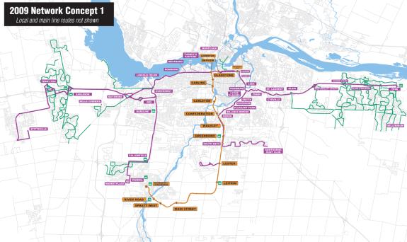
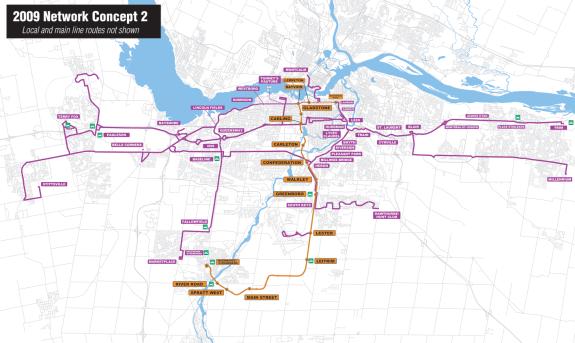
RECOMMENDED ROUTE NETWORK CONCEPT
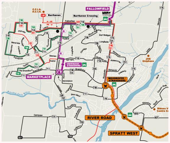
RECOMMENDED ROUTE NETWORK CONCEPT
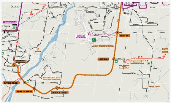
RECOMMENDED ROUTE NETWORK CONCEPT
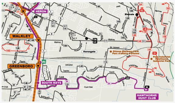
RECOMMENDED ROUTE NETWORK CONCEPT
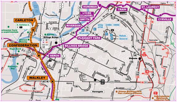
RECOMMENDED ROUTE NETWORK CONCEPT
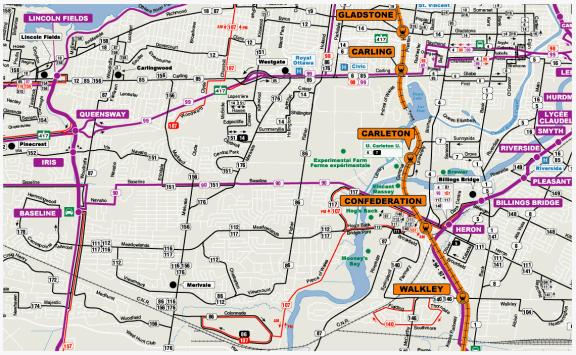
RECOMMENDED ROUTE NETWORK CONCEPT
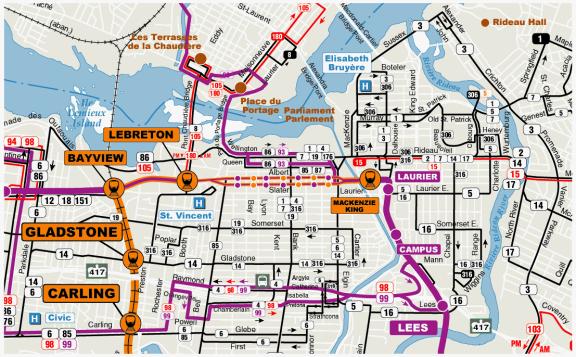
RECOMMENDED NEW RAPID TRANSIT BUS ROUTE
RECOMMENDED ROUTE NETWORK CONCEPT
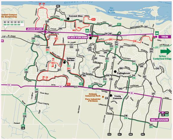
RECOMMENDED ROUTE NETWORK CONCEPT
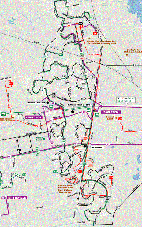
RECOMMENDED EXPRESS ROUTES