Report to/Rapport au :
Transportation
Committee
Comité des transports
and Council / et au Conseil
1
October 2004 / le 1 octobre 2004
Submitted
by/Soumis par :
R.T. Leclair, Deputy City Manager / directrice
municipale adjointe
Public Works and Services/Services et Travaux publics
Contact
Person/Personne-ressource : Michael J. Flainek, P. Eng./ing.,
Director/directeur
Traffic & Parking
Operations/Circulation et Stationnement
(613)
580-2424 x/poste 26882, Michael.Flainek@ottawa.ca
|
Ref
N°:
ACS2004-TUP-TRF-0019
|
|
SUBJECT:
|
Glebe traffic management implementation Study
|
|
|
|
|
OBJET :
|
ÉTUDE DE MISE EN œuvre SUR LA GESTION DE LA
CIRCULATION DANS LE GLEBE
|
REPORT
RECOMMENDATIONS:
That Transportation
Committee recommend that Council:
1. Receive the Glebe Traffic Plan as
approved by the Glebe Community Association (Annex 2).
2. a) Approve the recommendations of the
Glebe Traffic Management Implementation Study as listed in Annex 3 of this
report.
b) Approve the publishing of a “Notice of
Completion” for those components of the study that require an environmental
assessment as noted in Annex 3 of this report.
3.
Approve the following measures to be
implemented concurrently:
a) The prohibition of right turns from northbound Bronson
Avenue between Findlay Avenue and Renfrew Avenue and from eastbound Chamberlain
Avenue to Imperial Avenue, as detailed in Annex 6 of this report, to reduce the
impact of through traffic on the community during the morning peak period; and,
b) Modifications to the intersection of Carling Avenue and
Bronson Avenue, to address current safety issues, subject to funding approval
in the 2005 Capital Budget.
RECOMMENDATIONS DU RAPPORT :
Que
le Comité des transports recommande au Conseil municipal :
1.
de prendre connaissance du
Plan de circulation du Glebe approuvé par l’Association communautaire du Glebe
(annexe 2).
2.
a) d’approuver les recommandations de l’Étude de mise en œuvre
sur la gestion de la circulation dans le Glebe énumérées dans l’annexe 3 du
présent rapport.
b) d’approuver la diffusion d’un avis
d’achèvement pour les éléments de l’étude qui requièrent une évaluation
environnementale. Ces éléments sont mis en évidence dans l’annexe 3 du présent
rapport.
3. d’approuver la mise en œuvre simultanée des mesures
suivantes :
a) L’interdiction
des virages à droite de l’avenue Bronson en direction nord, entre les avenues
Findlay et Renfrew, et de l’avenue Chamberlain en direction est jusqu’à
l’avenue Imperial, comme le précise l’annexe 6 du présent rapport, en vue de
réduire la circulation de transit dans le secteur pendant la période de pointe du matin,
b) Les
modifications apportées à l’intersection des avenue Carling et Bronson visant à
améliorer la sécurité à cet endroit, sous réserve de l’approbation du
financement dans le cadre du budget des immobilisations de 2005.
EXECUTIVE SUMMARY
Assumptions
and Analysis
In 1998, the Glebe Community
Association, along with the former City of Ottawa and the former Regional
Municipality of Ottawa-Carleton, started a formal traffic review of the Glebe
neighbourhood. Phase 1 of the Glebe
Area Transportation Study was completed in late 2000. The Study developed a detailed list of traffic-related issues and
concerns through a series of meetings, walkabouts, data collection exercises,
and observations. Unfortunately, at the
time, there was insufficient funding available for further municipal
involvement in the Study.
The Glebe Community Association decided to
continue with the work on its own and produced the Glebe Traffic Plan (GTP)
(Annex 2). The GTP, which was approved
by the Glebe Community Association on 26 February 2002, provided an analysis of
each of the problem sets identified, that included the problem definition, the
community vision/desired state, and over 70 detailed recommendations of how to
solve the problems.
Following receipt of the
GTP, the City undertook the Glebe Traffic Management Implementation Study to
assess and evaluate the GTP from a technical perspective. It considered the relative merits of the
recommended traffic management/calming measures, identified any potential
changes, and more importantly, developed an implementation program. The measures from the GTP that were deemed
to effectively solve quantifiable problems are carried forward for
recommendation and are shown in Annex 3; those that are deferred and/or
forwarded to others for consideration are shown in Annex 4; and those that are
not recommended are shown in Annex 5.
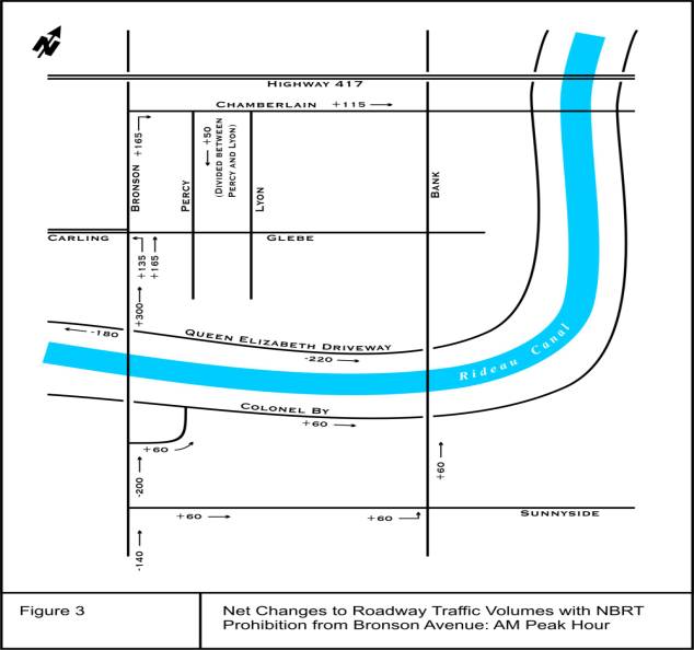
Annex 6 provides
technical details about the specific recommendation to reduce
the traffic on Findlay Avenue, Broadway Street and Torrington Place. The Glebe Traffic Plan made a recommendation
to prohibit northbound right turns from Bronson Avenue onto Findlay Avenue
during the AM peak period. Realizing
that this would simply shift the problem onto the next available street, they
further recommended that all intersections between the Rideau Canal and
Chamberlain Avenue be subject to the same restriction, thereby ensuring that
traffic remains on the arterial road network and not on the local road network. As this would have considerable impacts on
other streets in the area, a detailed analysis was carried out by the City to
properly understand the full implications of the recommendation. Staff recommend that the implementation of
the right-turn prohibitions on Bronson Avenue be carried out concurrently with
safety improvements currently under review for the intersection of Bronson
Avenue and Carling Avenue, to ensure that safety issues are addressed at this
intersection.
Financial Implications
Approval of expenditures for
the implementation of the recommended measures will form part of the annual
Capital Budget process.
Public Consultation/Input
Public consultation was a
key aspect of the Glebe Traffic Management Implementation Study. It included a newspaper advertisement
indicating that the Study was underway, a Steering Committee made up of
community representatives, and a Public Open House held on 5 June 2003.
RÉSUMÉ
Hypothèses et analyse
En 1998, l’Association communautaire du Glebe, l'ancienne Ville d'Ottawa et
l'ancienne Région d'Ottawa-Carleton ont entrepris une étude officielle de la
circulation dans le quartier du Glebe. À la fin de 2000 s’est achevée la
première phase de l’Étude de la circulation dans le Glebe, laquelle a permis d’établir
une liste détaillée de questions et de problèmes liés à la circulation
automobile à la faveur de réunions, de visites guidées, de collectes de données
et d’observations. À l’époque, la Ville ne disposait malheureusement pas des
ressources financières voulues pour pousser cette étude plus loin.
Ayant décidé de
poursuivre les travaux seule, l’Association communautaire du Glebe a produit le
Plan de circulation du Glebe (PCG)
(annexe 2), qu’elle a approuvé le 26 février 2002. Ce plan comportait
une analyse de chaque série de problèmes recensée, la définition des problèmes,
la vision des résidents du quartier ou la situation souhaitée ainsi que plus de
70 recommandations détaillées sur les solutions possibles.
Après avoir pris
connaissance du PCG, la Ville a entrepris l’Étude sur la mise en oeuvre de
mesures de gestion de la circulation dans le Glebe en vue d’analyser et
d’évaluer le plan d’un point de vue technique.
Elle a étudié le bien-fondé relatif des mesures de gestion et de
modération de la circulation envisagées pour le Glebe, a proposé certains
changements et, surtout, a conçu un plan de mise en oeuvre. Les mesures préconisées dans le PCG qui, de
l’avis de la Ville, permettent de régler efficacement des problèmes
quantifiables sont retenues en vue d’être recommandées et figurent à
l’annexe 3; celles qui sont reportées ou transmises à d’autres instances
chargées de les examiner figurent à l’annexe 4 alors que celles qui ne
sont pas recommandées sont à l’annexe 5.
L’annexe 6
présente des détails techniques sur la recommandation concernant la réduction
de la circulation sur l’avenue Findlay, la rue Broadway et la place
Torrington. Le Plan de circulation du
Glebe propose d’interdire les virages à droite sud-nord à partir de l’avenue
Bronson vers l’avenue Findlay pendant la période de pointe du matin. Comme cette solution ne ferait que
transposer le problème à la première rue pouvant être empruntée, le plan
recommande en outre que toutes les intersections situées entre le canal Rideau
et l’avenue Chamberlain soient assujetties à la même restriction, ce qui
obligerait les automobilistes à emprunter le réseau des grandes artères et non
celui des voies de circulation locales.
Comme cette mesure se répercuterait de façon non négligeable sur les
autres rues du quartier, la Ville a entrepris une analyse détaillée de cette
recommandation afin d’en bien mesurer toutes les conséquences. Le personnel recommande que la mise en
oeuvre de l’interdiction de tourner à droite à partir de l’avenue Bronson
intervienne parallèlement aux améliorations à la sécurité envisagées
actuellement à l’angle des avenues Bronson et Carling afin de répondre aux
problèmes de sécurité que pose cette intersection.
Répercussions financières
L’approbation des dépenses nécessaires à la mise
en œuvre des mesures recommandées fera partie du processus annuel
d’établissement du budget des immobilisations.
Consultation
publiques / commentaires
La
consultation du public a représenté un aspect essentiel de l’Étude sur la mise
en oeuvre de mesures de gestion de la circulation dans le Glebe. La Ville a notamment passé une annonce dans
les journaux indiquant que l’étude était en cours, créé un comité directeur
composé de représentants de la collectivité et tenu une séance portes ouvertes
le 5 juin 2003.
BACKGROUND
In 1998, the Glebe Community Association, along with the former City of
Ottawa and the former Regional Municipality of Ottawa-Carleton, started a
formal traffic review of the Glebe neighbourhood. Phase 1 of the Glebe Area Transportation Study was completed in
late 2000. The Study developed a
detailed list of traffic-related issues and concerns through a series of
meetings, walkabouts, data collection exercises, and observations. It also made a series of recommendations to
address these issues and concerns with the understanding that further
feasibility studies/detailed design studies would be required. Unfortunately, at the time, there was insufficient funding available
for further municipal involvement in the Study.
The Glebe
Community Association decided to continue with the work on its own and, in
2002, produced the Glebe Traffic Plan (GTP) (Annex 2). It divided the Glebe/Dow's Lake area into
three distinct but related problem sets: the Bronson Corridor, the Queen
Elizabeth Driveway, and the rest of the Glebe (which was further divided to
allow for local issues to be resolved).
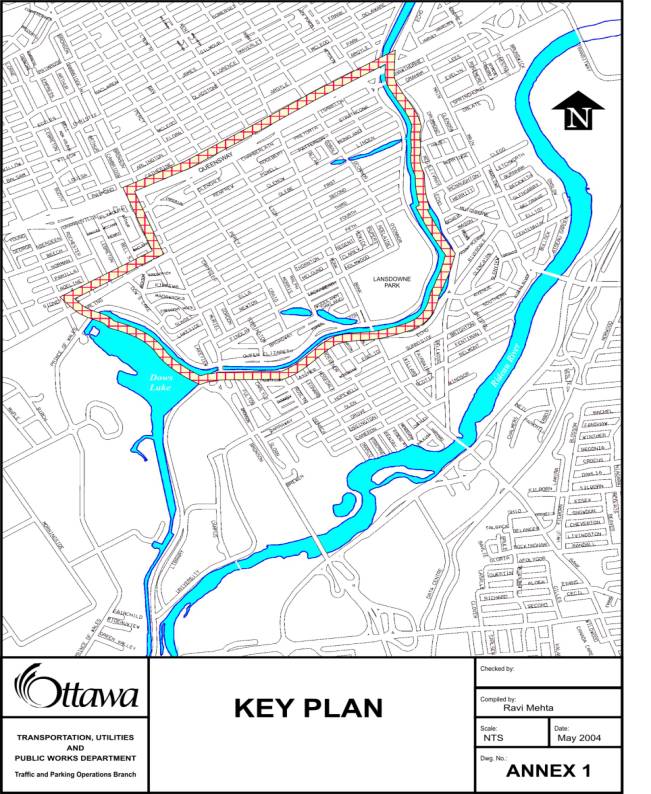
A map of the study area can be found in Annex 1. The GTP provided an analysis of each of the
problem sets that included the problem definition, the community vision/desired
state, and over 70 detailed recommendations of how to solve the problems.
The GTP
involved many hours of community consultation and concensus within the
community was reached on the measures outlined in the plan. The GTP was approved by the Glebe Community
Association on 26 February 2002. The
community has high expectations that most, if not all, of the measures will be
implemented.
DISCUSSION
Following receipt of the GTP, the City undertook the Glebe Traffic
Management Implementation Study to assess and evaluate the GTP from a technical
perspective. It considered the relative
merits of the recommended traffic management/calming measures, identified any
potential changes, and more importantly, developed an implementation
program. The Study also completed the
necessary work to ensure compliance with “Schedule B” of the Municipal Class
Environmental Assessment. It was not
the intent of staff to revisit previous efforts, but rather to ensure that
proposals were technically sound, and to develop an implementation plan that
establishes the process of mitigating negative traffic impacts in the Glebe
community.
For each of the measures (or group of measures, if appropriate) proposed
in the GTP, this implementation study carried out the following technical
analysis:
· Data
was collected to verify the extent of the problem being addressed. This
included speed surveys, traffic counts, road geometrics, etc.
· Based
on the data, warrant analyses were carried out to determine whether there was a
quantifiable problem to solve. This was
important as all of the measures cost money, and the intention is to spend
money only on measures that would solve quantified problems.
· For
those issues that were quantified and determined by staff to be problems, the
proposed measures were studied to determine if they were appropriate in solving
or partially solving the problem which they were meant to address. If they were not, alternative measures were
identified.
- If proposed solutions
potentially caused traffic to be diverted onto other streets, the negative
effects caused by this diverted traffic were predicted. Ways of mitigating these effects were
developed and included in the study recommendations if deemed necessary.
The measures from
the GTP that were deemed to effectively solve quantifiable problems are carried
forward for recommendation and are shown in Annex 3; those that are deferred
and/or forwarded to others for consideration are shown in Annex 4; and those
that are not recommended are shown in Annex 5.
Annex 6 provides
technical details about the specific recommendation to reduce
the traffic on Findlay Avenue, Broadway Street and Torrington Place. The Glebe Traffic Plan made a recommendation
to prohibit northbound right turns onto Findlay Avenue. Realizing that this would simply shift the
problem onto the next available street, it further recommended that all
intersections between the Rideau Canal and Chamberlain Avenue be subject to the
same restriction, thereby ensuring that traffic remains on the arterial road
network and not on the local road network.
Since the problem was more pronounced in
the morning peak period, and since this was seen as the time period when
community access was least critical, the community plan recommended that this
prohibition only be in place between 7:00 a.m. and 9:00 a.m., Monday to
Friday. As this would have considerable
impacts on other streets in the area, a detailed analysis was carried out by
the City to properly understand the full implications of the recommendation.
The most significant of the negative impacts of the
right-turn prohibitions are the increased traffic volumes predicted at the
Bronson Avenue/Carling Avenue intersection.
This intersection is currently very congested during the morning
peak hour, with long northbound queues of traffic forming, and an average
of 19 collisions occurring per year.
The predominant collision pattern is northbound left-turning vehicles
conflicting with southbound through vehicles. The current collision rate
for this type of crash is five times higher at this intersection than
the average rate. This is further exacerbated by the large number of southbound
drivers running red lights as evidenced in the high number of violations
captured by the red-light camera at this location. This intersection is
currently under review in the Safety Improvement Program to reduce the number
of collisions and address pedestrian concerns at the intersection. The collision situation is expected to
worsen with implementation of the right-turn prohibitions
on Bronson Avenue. It is
predicted that an additional 135 vehicles per hour will turn left onto Carling
Avenue from northbound Bronson Avenue, increasing the level of congestion, leading
to increased delays for motorists, which may lead to an increase in the number
of collisions due to the increased risk that drivers will accept as they turn
left through the intersection. Remedial measures may include shortening
the pedestrian walking distances across the intersection and creating a
protected northbound left-turn phase.
It is therefore recommended that the implementation
of the right-turn prohibitions on Bronson Avenue be carried out concurrently
with the safety improvements currently under review for the intersection
of Bronson Avenue and Carling Avenue to ensure that safety issues are addressed
at this intersection. This review will
also take into consideration the City’s transit priority needs as Carling
Avenue, between Bayshore Drive and Bronson Avenue, is designated a Transit Priority
Corridor in the City’s Official Plan.
ENVIRONMENTAL IMPLICATIONS
The Municipal Class Environmental
Assessment classifies the speed humps recommended in this report as “traffic
calming.” These measures, as well as
any other measures that are directly related to or dependent on these traffic
calming measures (i.e. address the same specific problem as the recommended
traffic calming measures), will require completion of the Municipal Class
Environmental Assessment – “Schedule B” (i.e. estimated implementation cost is
less that $1,500,000). This process
requires several key steps to be followed including a mandatory public
consultation regarding the problem and the alternative solutions (this step
already completed). Non-traffic calming
measures that are not directly related to or dependent on traffic calming
measures are considered “Schedule A” (or pre-approved) with respect to the
Municipal Class Environmental Assessment process, and are therefore approved
once approved by Council.
For those measures that require Municipal
Class Environmental Assessment approval, following Council approval of the
recommendations of this report, a “Notice of Completion” will be published in
the Ottawa Citizen and Le Droit advising the public that the Study is complete
and the process that should be followed if there are any outstanding concerns
with the proposed traffic calming components.
This process includes attempting to resolve the concerns with the City,
and, if the concerns cannot be resolved, requesting that the Minister of the
Environment order an “Individual Environmental Assessment.” The Minister must receive this request
within thirty days of the “Notice of Completion.” Following receipt of the request and further attempts on the part
of the City to resolve the concerns raised, the Minister, upon reviewing the
project file, may either approve the project or order that an “Individual
Environmental Assessment” be carried out.
If no concerns are brought forward within 30 days of the “Notice of
Completion,” these measures are automatically approved.
CONSULTATION
Public consultation was a
key aspect of the Glebe Traffic Management Implementation Study. It included a newspaper advertisement
indicating that the Study was underway, a Steering Committee made up of
community representatives, and a Public Open House held on 5 June 2003.
Approximately 150 members of the public
attended the Public Open House held at the Glebe Community Centre on 5 June
2003. An open format took place between
6:00 p.m. and 7:30 p.m. People were
encouraged to read display panels, ask questions and provide input and ideas to
staff. Between 7:30 p.m. and 9:00 p.m.,
the format changed to a question and answer period where the public could ask
questions and provide input to staff.
Following the release of the
draft recommendations, the Glebe Community Association organized a walkabout of
the Glebe and provided further suggestions to improve the plan, building on
their original recommendations. These
were studied and many are being recommended for implementation. These are listed in Annex 3.
Although newspaper ads were place in the
daily newspapers, the majority of the consultation was directed to the Glebe
and Dows Lake communities. It is
recognized that other communities will also be affected by the proposals,
particularly communities to the south whose residents use Bronson Avenue as
their primary commuter route. As
changes proposed in this report will restrict access to the Findlay Avenue /
Broadway Street / Torrington Place for morning northbound commuters,
alternative routes will have to be taken.
Commuters will be required to use the arterial road network (as is
intended) rather that the local residential streets. As the affected streets are designated as local roads in the
City’s Official Plan, consultation was focused on the local (Glebe and Dow’s
Lake) communities.
TRANSPORTATION MASTER PLAN
The Study
recommendations are in accordance with the mandate of Area Traffic Management
as defined in Section 9.6 the Transportation Master Plan. The Transportation Master Plan describes
Area Traffic Management as both a process and technique of preserving
neighbourhood liveability by mitigating the undesirable effects of motor
vehicle travel including excessive traffic volumes and speeds, aggressive drive
behaviour and the creation of unfavourable conditions for walking and cycling.
FINANCIAL IMPLICATIONS
Approval of expenditures for the implementation
of the recommended measures will form part of the annual Capital Budget process.
The total cost of the measures
identified in this report is $544,600.
Cost estimates of each of the individual recommended measures are
provided in Annex 3. Full implementation
of the measures recommended in this report will result in an estimated $18,000
in additional annual operating costs for the City. These costs will need to be added to the Operating Budget as a
pressure at the time that these measures are implemented.
In
2002, $100,000 was provided in the Capital Budget under Internal Order # 900685
for the Glebe Study identified in this report.
A purchase order was set up for $72,600,
including net taxes. Net payments to
date total $67,500.
The
Sign Maintenance Operating Budget can accommodate the estimated cost of the
turn restriction sign installation, estimated at $2,000.
SUPPORTING DOCUMENTATION
Annex 1 Key Plan
Annex 2 The Glebe Traffic Plan, 2002
Annex 3 Measures Recommended by Staff for
Implementation
Annex 4 Measures Deferred and/or Forwarded to
Others for Consideration
Annex 5 Measures Not Recommended for
Implementation
Annex
6 Detailed Evaluation of the
Proposed Northbound Bronson Avenue Right-Turn Prohibitions
DISPOSITION
Subject to approval by
Council of the recommendations contained in Annex 3 of this report, a “Notice
of Completion” will be published in the Ottawa Citizen and Le Droit advising
the public that the Study is complete and the process that should be followed
if there are any outstanding concerns related to measures that require
completion of the Municipal Class Environmental Assessment - Schedule B.
The approved measures will be implemented
based on the needs-based priority system detailed in the draft Area Traffic
Management Guidelines. Measures that
rely solely on signage or pavement markings will be implemented as soon as
possible.
ANNEX 1
KEY PLAN
ANNEX
2
ANNEX 2
Glebe
Traffic Plan, 2002
Amended
and Approved by the Glebe Community Association
FEBRUARY
26, 2002
GLEBE
TRAFFIC PLAN 2002
AMENDED
AND APPROVED
BY GCA
FEBRUARY
26, 2002
Preamble:
This document is the
culmination of five years work and extensive public consultation. Drawing upon the recommendations of Cumming
Cockburn and JP Braaksma and Associates, consultants hired to assist the
community with its review, the Glebe Community Association (GCA) Traffic
Committee has elaborated a consolidated traffic plan for the Glebe/Dow’s Lake
area. The Plan builds upon the measures
introduced in the original Glebe Traffic Plan of the early 1970’s and is
presented as an integrated set of measures, interlinked and indivisible. While the Plan is designed to deal with both
general and specific traffic issues affecting this community, the members of
the Traffic Committee recognize that additional measures not set out in the
Plan may well be necessary in the future.
The Glebe Traffic Plan 2001 is based on the
following principles, which have been widely endorsed by community members
during the course of over three years of consultation:
·
Priority within the neighbourhood shall be given to the
safety and comfort of pedestrians,
cyclists and residents;
·
Traffic flowing through the Glebe shall be largely
restricted to arterial roads in such a way as to minimize its effect on
the neighbourhood and its core shopping and community facilities;
- The existing restrictions on entry and
flow within the neighbourhood shall be maintained and enhanced; and,
- While entry and egress by Glebe residents
will necessarily be affected by the measures set out in the plan, measures
shall distribute such effects as equitably as possible consistent with the
overall objective of restricting traffic flow through the community.
Background
During the 1990’s, issues related to the growing impact of traffic
traveling through the Glebe and Dow’s Lake areas increasingly became the focus
of discussion at meetings of the Glebe and Dow’s Lake Community
Associations. Complaints regarding the
number of vehicles using residential streets within the Glebe and Dow’s Lake to
access the downtown core from other parts of the City and Region, and the
threat to pedestrian safety and quality of life posed by vehicular traffic,
grew in both number and intensity during this period.
ANNEX
2
Beginning in 1997, deliberations of the Traffic Committee of the GCA
turned to the need for coordinated action to deal with problems created by
levels of traffic that could no longer be adequately accommodated within the
framework of the original Glebe Traffic Plan implemented in the early 1970’s.
In response to a formal request by the GCA in early 1998, the former
Regional Municipality of Ottawa-Carleton approved funding for a traffic study
for the Glebe and Dow’s Lake communities.
In preparation for the launch of the study, many local residents
participated in a major consultation exercise aimed at developing an inventory
of traffic-related problems. A Public
Workshop was held in September 1998 to identify the issues. Evidence of the high level of community
concern about traffic in the Glebe was provided by the active participation of
over 100 community members in the gathering of traffic data during the Fall
1998 – one of the largest such initiatives ever undertaken in the Ottawa area.
On 21 April 1999, the GCA Traffic Committee, working with municipal
staff, finalized the Terms of Reference for the Glebe Traffic Review. The consultants who were to conduct the
review were selected at the end of June 1999.
Following initial review of the available data and consultation with
residents over the course of a series of neighbourhood “walkabouts”, the
consultants prepared a Background Report setting out their summary of the
traffic-related problems facing the community.
An Open House was held in June 2000 to confirm and invite comment on the
various traffic-related problems that area residents had identified. Consultants analyzed the over 200 individual
submissions and proposed potential corrective measures which were set out in
their Final Report to the former Regional Municipality of Ottawa-Carleton.
The Glebe Traffic Plan 2001
is organized around three distinct, but related, problem sets – (1) the Bronson
Avenue Corridor, (2) the Queen Elizabeth Driveway and (3) the “Rest
of Glebe” (ROG).
While the last category was
considered as “one” problem area for the purposes of identifying community-wide
issues requiring a common treatment, it was further broken down geographically
to allow the Committee to address localized problems and propose appropriate
corrective measures. These are: Area
1: Dows Lake (bounded by Queen Elizabeth Driveway, Carling and Bronson); Area
2: Southwest Glebe (bounded by Fifth, Bronson, Queen Elizabeth Driveway and
Bank); Area 3: Glebe West (bounded by Fourth, Bronson, Glebe and Bank); Area
4: Northwest Glebe (bounded by Clemow, Bronson, Chamberlain and Bank); Area
5: Bank Street (Canal to Queensway); Area 6: Southeast Glebe
(bounded by Bank, Glebe/First and Queen Elizabeth Driveway); And Area 7:
Northeast Glebe (bounded by Bank, Isabella, Queen Elizabeth Driveway and Linden
Terrace/Clemow).
The elaboration of the Glebe
Traffic Plan 2001 was guided by the principles set out above. Building on these, the Committee first
envisaged each problem area in terms of the intended effect of any proposed
improvements, before moving on to identify the proposals themselves.
ANNEX
2
The Glebe Traffic Plan
proposes measures to manage existing traffic.
It was beyond the scope of its terms of reference to address broader issues
of overall transportation demand management and its effects on the quality of
life in the inner city. However, the
community wishes to express its concurrence with the findings and
recommendations of the Airport Parkway Extended Traffic Impact Study (APETIS)
Steering Committee Report, particularly those encouraging the use of more
community-friendly modes of transportation, such as light rail.
In many significant ways, the Glebe/Dows Lake area resembles a village,
a village oriented towards its commercial center, or a main street (Bank). Virtually all residents in the community
live within three quarters of a mile of that main street – a feature that,
along with the availability of a complete range of essential personal, retail
and commercial services, accounts for the extraordinary sense of community
identification and cohesiveness. Ours
is a mixed-age community and our residents walk more than do those of the
suburbs. The safety, comfort and
security of our sidewalks and intersections, and the careful and appropriate
behaviour of motor vehicle drivers, are vitally important to the continued
well-being and well-functioning of our village.
Our Traffic Plan will preserve the continued health and vibrancy of our
village and maintain and sustain the integrity of individual neighbourhoods
within the wider community.
Our Plan will reduce the number of cars being driven on our local
residential streets and encourage slower and more respectful driving. Our Plan looks to the City of Ottawa and the
Ottawa Police to diligently enforce all traffic regulations through an ongoing
highly visible program designed to enhance the safety and viability of
vehicular traffic in the Glebe and Dow's Lake area. Our Plan also envisages sidewalks that are safe and comfortable
to use – wide enough for people to pass comfortably and designed for walking
not cars.
Our streets will be used in ways that are appropriate to their essential
character and that enhance the safety, security, comfort and enjoyment of all
users, whether resident or visitor. Our
streets will be pleasant to travel along whatever the chosen mode of
transportation.
Our Plan will focus
improvements on streets so as to ensure that solutions do not simply shift the
problem elsewhere.
Our Plan recognizes, accounts
for, and will not interfere with the operation of emergency vehicles and public
transportation.
Bronson
Avenue Corridor:
Problem
Definition
Bronson Avenue is now used extensively as an express link between
communities in the south end of the region and the Queensway, downtown, and the
bridges to the Outaouais. Enhanced
access to the Airport Parkway has increased the volume of traffic on Bronson,
which, in turn, has increased the number commuters using local residential
streets to bypass the congestion.
ANNEX
2
The volume and excessive speed of traffic on Bronson now constitutes a
significant barrier separating Dow’s Lake from the Glebe.
Aggressive and inconsiderate
drivers run through intersections, ignoring signals and endangering those
crossing – particularly children, older people and the disabled. Close proximity to fast, dense traffic is
menacing to pedestrians and cyclists, inhibiting the use of these
environmentally friendly, community sustaining modes of transportation.
Community
Vision/Desired State
Dow’s Lake and the Glebe
form a single, contiguous, integrated community. Bronson Avenue is primarily a residential street, the
scale and ambience of which should be consistent with the rest of the
neighbourhood. Bronson should not
constitute a barrier to movement between the two neighbourhoods.
The realization of our vision calls for measures that will allow Bronson
Avenue to continue to offer access to the downtown while at the same time
enhancing the safety and comfort of all users and the adjacent neighbourhoods.
Recommendations
Safety (Speed)
- Reduce existing speed limits along Bronson
to 60 km/h at the Dunbar Bridge, to 50 km/h at Sunnyside and to 40 km/h at
the Bronson Bridge;
- Establish a Community Safety Zone in the
40 km/h zone on Bronson from the Bronson Bridge to Chamberlain, with
higher fines and increased enforcement.
Examples are similar zones established on Smythe Road and on Dynes
Road. This would include measures
such as signs stating increased fines in the Community Safety Zone;
- School crossing signs on Bronson at the
Glebe/Carling intersection. Lift restrictions on off-peak parking;
- Install from time to time, a visible,
speed-feedback monitor on or near the Bronson Bridge;
- Adjust the synchronization of the signal
lights at all Bronson intersections to support the above-noted speed
limits;
- Mark pedestrian crossings with permanent
acrylic zebra stripes; and,
- Have City staff study the results of an
experiment in Indianapolis that linked speed signs with red lights: “Warning, if you exceed the speed
limit, the upcoming traffic light will turn red.”
Intersections
- Adjust traffic signal cycles to provide
more time for pedestrians to cross at Holmwood, Fifth, Carling, and Powell
Avenues;
- Reduce the waiting time for pedestrian
crossings on Bronson;
- Install Red Light Cameras at first traffic
light north of Sunnyside, in addition to the one at Carling Avenue, to
inhibit drivers running red lights;
ANNEX
2
- Install photo radar cameras at the Bronson
Bridge, in addition to the one at Carling Avenue, as soon as this traffic
enforcement measure is once again approved by the Provincial legislature;
- Install a new traffic light at the
intersection of Bronson and Findlay Avenues;
- Install a pedestrian activated traffic
signal mid-block between Second and Third Avenues to facilitate pedestrian
crossing. This signal should be
synchronized with the other traffic signals on Bronson; and,
- Install an audible signal at Fifth and
Bronson.
Traffic Management:
Reduce Cut-through Traffic
- During AM Peak, prohibit right turns from
Bronson northbound, between Bronson Bridge and Chamberlain Avenue.
(Bicycles Excepted - suggest same restriction at Sunnyside);
- During AM Peak, prohibit left-turns from
Bronson northbound at Madawaska and Kippewa (Bicycles Excepted);
- Reconfigure the Bronson/Chamberlain
intersection, and add an on-ramp from Chamberlain to the Queensway. Make use of the opportunity to purchase
the unused Board of Education property to provide additional space for the
on-ramp. This will reduce cut-through
traffic in the Glebe, and take traffic off Chamberlain and Isabella;
- At the existing billboard at Bronson and
Carling, have OC Transpo advertise the O-Train as an alternative for
Bronson commuters;
- Prohibit left-turns from Bronson
northbound onto Sunset (24/7), (Bicycles Excepted);
- During AM Peak, prohibit access to Glebe
Avenue from Carling Avenue eastbound (Buses, Emergency Vehicles, and
Bicycles Excepted);
- During AM Peak, prohibit right turns onto
Imperial (Buses, Emergency Vehicles, and Bicycles Excepted); and,
- During PM Peak, prohibit access to Glebe
Avenue from Carling Avenue eastbound (Buses, Emergency Vehicles, and
Bicycles Excepted). As well,
prohibit right turns onto Powell, Renfrew, and Imperial (Buses, Emergency
Vehicles, and Bicycles Excepted).
Sense of Neighbourhood:
Streetscaping
- Landscape Bronson Avenue (in particular,
plant trees);
- Install lower, ornamental street lighting,
as in Somerset Village or on Clemow Avenue;
- Allow off-peak parking;
- Post signage to advise drivers that they
are entering/traveling through a residential district; and,
- Offer incentives to encourage
compatible/complementary street-oriented commercial redevelopment of
Bronson Avenue between First Avenue and the Queensway.
ANNEX
2
Queen Elizabeth Driveway
Transfer:
Problem
Definition
Drivers use Findlay, Broadway, and Torrington Avenues on the east side
and Lakeside Avenue on the west side (all densely populated residential
streets) to transfer between Bronson Avenue and the Queen Elizabeth
Driveway. The incentive to use the
Queen Elizabeth Driveway has been heightened by a dedicated northbound turning
lane, beginning south of the Bronson Bridge and merging with Findlay
Avenue. This turning lane also
eliminated the northbound bicycle lane on the Bronson Bridge, encouraging
cyclists to use the sidewalks, creating a conflict with pedestrians.
This arrangement dates back
to the 1960’s, when the Bronson Bridge was constructed and the old Bronson
Avenue was redirected, it presumed the expropriation of the properties adjacent
to Bronson on the north side of the Canal for a dedicated ramp to/from the
Queen Elizabeth Driveway (as exists on the south side). As the expropriation was never undertaken,
the existing residential road network has been forced to absorb this transfer
traffic.
Initially, Bronson Avenue
carried relatively little traffic, as the Airport Parkway functioned solely as
a dedicated route to and from Ottawa International Airport. With the effective conversion of the Parkway
to a commuter corridor serving south-end communities, the number of drivers
transferring to Queen Elizabeth Driveway has increased dramatically, to the
point where the roads have become almost unusable during the morning rush hour
and residents fear for the safety of their school-aged children.
Clearly, the weekday, peak
hour volume on these residential streets is excessive and unacceptable. More than 1000 vehicles currently travel the
Findlay, Broadway, Torrington leg between 7:00 a.m. and 9:00 a.m. The situation is aggravated further by the
behaviour of drivers, many of whom travel too fast and fail to respect stop
signs.
Finally, these streets carry too much and inappropriate commercial
traffic, such as large tour buses.
Community
Vision/Desired State
Findlay, Broadway, Torrington
and Lakeside will regain their character as quiet, family-oriented residential
streets. Weekday commuter traffic will
not cut through residential neighbourhoods but will remain on the appropriate
arterial roads.
Drivers using all
residential streets will do so in ways that are mindful of the safety, comfort
and security of the people living there.
This vision can be realized only by substantially reducing the volume of
traffic on these streets and by introducing measures that will constrain driver
behaviour in ways that are compatible with the quiet, residential character of
the neighbourhood.
ANNEX
2
Recommendations
Volume
- Prohibit right turns from Bronson Avenue
northbound during the AM Peak to significantly reduce volume (Bicycles
Excepted - see Bronson Corridor recommendations);
- Eliminate the third (dedicated turning)
northbound lane over the Bronson Bridge.
This would return the Bronson Bridge to the previous design, which
protected Findlay. It would
provide increased pedestrian safety on Bronson, Findlay, Broadway, and
Torrington;
- Install a traffic signal at the
intersection of Bronson and Findlay Avenues;
- Reconstruct the intersection of Bronson
and Findlay Avenues to reduce turning radii;
- Establish a bicycle lane northbound on the
Bronson Bridge to Holmwood. This
will encourage cyclists away from the sidewalks and to use the existing
Bronson/Holmwood/Craig/Percy cycling route;
- Add signage to direct cyclists to follow
the Holmwood/Craig/Percy cycling route; and,
- No right turns on red at proposed traffic
light at Findlay and Bronson.
Behaviour
- Post more explicit and larger signage on
the Bronson Bridge indicating that drivers are now on a residential street
and now entering a residential neighbourhood;
- Subject taxi and other commercial drivers
to special restrictions/ penalties with respect to traffic infractions;
and,
- Install a bulbout at the intersection of
Lakeview and Bronson.
Speed
- Install a sign on the Bronson Bridge
warning drivers to “Be Prepared to
Stop”;
- Install speed humps on Broadway Avenue,
Findlay and Torrington Avenues between Bronson Avenue and the Queen
Elizabeth Driveway;
- As for all residential streets in the
Glebe, limit speed on Broadway, Findlay and Torrington Avenues to 40 km/h,
with advisory that recommended speed is 30 km/h;
- Allow parking on both sides of Broadway
Avenue; and,
- Introduce staggered parking on Findlay.
Rest of Glebe:
Problem
definition
The vast majority of problems in the area are related to the
unacceptable volume of cut-through traffic and driver behaviour (compliance and
mindfulness) on our local residential streets.
Some streets are also subject to extraordinary volumes of traffic due to
decisions taken in the past regarding desired traffic routes for traffic to
take within and through the community.
Additionally, there are infrastructure issues, including the
inconsistent application of all-way stops, dysfunctional directional flow
patterns, and poor sidewalk design and maintenance.
ANNEX
2
Community
Vision/Desired State
Cars on residential streets
will be principally local traffic originating and/or terminating in the
community, or will belong to people visiting residents.
Drivers on local streets
will behave civilly and respectfully and will travel at a pace that does not
threaten pedestrians or compromise the quality of life of residents.
Sidewalks will be wide
enough for people to pass comfortably and designed and maintained so that they
may be walked on safely in all weather conditions.
Community-wide Recommendations
- Set speed limit on all streets to
40 km/h, as per provincial regulations;
- All-way stops introduced at all
intersections along Lyon, Percy, Chrysler, and O’Connor;
- Mid-block speed humps, bulb-outs, and
raised intersections on Glebe streets, with particular priority for
east-west and west-east oriented streets, east of Bronson; and,
- Implement Community Safety Zones around
all schools in the Glebe.
Area 1: Dow’s Lake (bounded
by Queen Elizabeth Driveway, Carling and Bronson)
Problem
Vehicles approaching Bronson
from Carling Avenue travel at excessive speeds, endangering pedestrians and
cyclists. They also produce noise and
splashing which is unpleasant for people whose residences border the road. Some drivers in sport utility vehicles
(SUVs) cross the sidewalk and barrier strip at Opeongo.
Recommendations
Eliminate the third lane on
Carling Avenue in each direction, which will allow for widening sidewalks and
additional streetscaping to increase residential setback. Specifically, on the south side of Carling,
eliminate the third lane between Cambridge and the tour bus parking area.
Maintain the tour bus parking area at its present size.
Add planters and trees at the barrier strip at Opeongo and Carling.
Problem
Vehicles anticipating a red
light at Fifth/Madawaska while traveling northbound along Bronson Avenue turn
left onto Sunset, usually at a speed that is inappropriate and thus unexpected
by the people living on that street.
The unexpected nature of the speed increases the danger to residents,
particularly to the young children.
Recommendations
Prohibit all left-turns onto
Sunset from Bronson Avenue (24/7 - Bicycles Excepted),
ANNEX
2
Narrow the Bronson-Sunset
intersection on south side with a bulbout.
Problem
Drivers are using local
streets to transfer between Bronson Avenue and Queen Elizabeth Driveway/Preston
Street.
Recommendations
During AM Peak, prohibit
left-turns from Bronson onto Madawaska and Kippewa Avenues. (Bicycles Excepted
- see Bronson Corridor Recommendations).
Study the impact of
the following: during PM Peak (3:30 p.m.- 5:30 p.m., Monday to Friday),
prohibit left-turns off Queen Elizabeth Driveway onto Lakeside and Crescent
Heights (Bicycles Excepted).
Introduce traffic calming
measures on Lakeside, as deemed necessary.
Possibilities to be studied are:
- Two-sided parking in non-winter months;
- Widen sidewalks; and,
- Introduce speed humps.
Maintain the following
traffic calming measures on Kippewa, Madawaska, and Opeongo:
- Kippewa: maintain one-sided parking in
winter and two-sided parking for rest of year;
- Madawaska: maintain two-sided parking, but
reduce parking near Bronson by 2 to 3 car lengths; and,
- Opeongo: maintain one-sided parking.
Add a pedestrian activated traffic light at Crescent Heights and Queen
Elizabeth Driveway.
Problem
Drivers accelerating
downhill on southbound route: Cambridge, Frederick, and Jackson, cutting
through from Carling to get to Madawaska/Bronson, or Kippewa/Bronson.
Recommendation
- Post stop sign at the northeast corner of
Frederick and Jackson (one-way stop).
Area 2: Southwest Glebe (Bounded by Fifth, Bronson, Queen Elizabeth
Driveway and Bank, but Excluding Queen Elizabeth Driveway)
Problem
Approaching drivers use
excessive speed and frequently disregard traffic signals, making the
intersection crossing at Holmwood and Bronson dangerous and uncomfortable for
pedestrians
ANNEX
2
(includes many Carleton
University students) to use. Further,
the signal cycle is heavily biased in favour of the north-south flow, which
encourages speeding and means pedestrians and other westbound traffic must wait
an uncomfortably long time. The
diminished turning opportunity induces drivers to speed up when approaching the
intersection from Holmwood Avenue. The
problems are accentuated in off-peak hours.
Recommendation
- Adjust signalization cycle to support
recommended speed limits and shorten button response time for pedestrians
wishing to cross.
Problems
A growing number of drivers
are using Fifth Avenue to transfer between Bronson Avenue and Bank Street. The volume on Fifth at Bronson exceeds 200
vehicles per hour during both the morning and afternoon peaks.
Intersection volume
encourages drivers (particularly taxis and other commercial vehicles) to use
Muriel Street and Gordon Street to avoid waiting for the lights at either Bronson
and Fifth or Bronson and Holmwood.
Cars traveling west along Fifth Avenue and anticipating a red light at
the Bronson Avenue intersection use Muriel Street to access Bronson at Holmwood
Avenue.
Recommendations
- Speed hump mid-block on Muriel;
- Raised intersection from Muriel to Gordon
on Holmwood instead of all-way stops;
- Add all-way stop at Torrington on
Holmwood;
- Reconfigure intersections of Muriel and
Gordon Streets and Fifth Avenue to ensure drivers slow down and use the
appropriate lane when turning onto the street;
- Establish parking on alternating sides of
the avenue for a chicane effect;
- Extend a streetscaping verge (about 3
feet) on the no parking sides of the Avenue;
- Plant trees on the verges;
- The existing placement of the sidewalk
will remain; and,
- This is made opportune and economical by
the pending reconstruction of Fifth Avenue.
Problem
Drivers at intersection of
Percy, Fifth and Craig often do not come to a full stop.
Recommendation
- Narrow streets at intersection and
introduce bulbouts to ensure cars come to a full stop and make the proper
turns from one street onto the other.
Problem
Drivers at the intersection of Fifth Avenue and Ralph Street (at
Mutchmor School) consistently ignore the all-way stops, endangering children
crossing at this location.
ANNEX
2
Recommendations
·
Add flashing signals to stop signs during school
crossing hours;
·
Modify intersection (narrow, bulbouts, bollards) to
ensure cars come to a complete stop;
·
Post additional signage indicating the presence of
children;
·
Paint zebra stripes over pedestrian crossing areas;
and,
·
Designate intersection as a community safety zone and
therefore a high fine area.
Problem
Speed of vehicles using
Queen Elizabeth Place between Bank Street and Queen Elizabeth Driveway,
creating a conflict between pedestrians and automobiles.
Recommendations
·
Add marked pedestrian crossing on Queen Elizabeth
Place at the Queen Elizabeth
Driveway;
·
Provide advanced green at proposed light at Wilton and
Bank, turning left onto Wilton, to reduce speed of drivers turning left.
Area 3: Glebe West (bounded
by Fourth. Bronson, Glebe and Bank)
Problem
Glebe Avenue directly links Carling eastbound with Bank Street and/or
Colonel By northbound (via the Pretoria Bridge). The volume of this traffic has grown dramatically (in fact Glebe
has experienced the highest percentage increase in traffic over the past few
years of any local residential street).
The fact that the street is unidirectional encourages drivers to travel
at inappropriate speeds between intersections.
Recommendations
·
During AM Peak, prohibit right turns from Bronson.
(Bicycles Excepted - see Bronson Corridor recommendations); and,
·
In order to allow residents access to their homes,
Glebe Avenue to become two-way between Percy and Bronson, but with no exit onto
Bronson from Glebe.
Area 4: Northwest Glebe
(bounded by Clemow, Bronson, Chamberlain and Bank)
Problems
High traffic speed and
volume on Chamberlain endanger children and pedestrians at school and
pedestrian crossings.
There is heavy volume on
Percy during peak periods resulting from commuters and other drivers trying to
avoid congestion on Bronson.
Cars using residential cross
streets to transfer between Bank Street and Bronson Avenue.
ANNEX
2
Recommendations
·
Community Safety Zone along Chamberlain from Imperial
to Kent with higher fines and increased enforcement;
·
School crossing for school children to access Glashan
School, and access physical education facilities in the Central Park chain at
multiple times during the day;
·
Prohibit morning peak right turns off Bronson
northbound will reduce cut-through traffic (Bicycles Excepted - see Bronson
Corridor recommendations); and,
·
Raised intersections on Chamberlain at pedestrian
crossings at Percy and at Kent.
Problem
High traffic volume on Powell because Clemow (the closest adjacent
street) cannot be accessed either at Bank or Bronson. Note that Powell is the entrance for Renfrew, Powell, Glebe, and
Clemow.
·
Mid-block “No
Through Traffic” signs on Powell between Lyon and Percy, except emergency
vehicles, buses, and bicycles;
·
Add bulbout mid-block;
·
Add signs at Powell and Bank and Powell and Bronson,
saying "Not a Through Street - Local
Traffic Only"; and,
·
Add signs at Powell and Percy and Powell and Lyon: “No Exit”.
Problem
The bus shelter on the small
island at the intersection of Bank and Chamberlain endangers those waiting at
the stop and impedes eastbound right-turning drivers’ view of southbound Bank
Street traffic.
Recommendation
·
Eliminate turning lane between Chamberlain and Bank. Convert
intersection to T-shape and eliminate island. Move the bus shelter further to
the west of the intersection.
Area 5: Bank Street (Canal
to Queensway)
Problem
Between Wilton/Canal Bridge and Fifth Avenue, cars using Bank Street
travel at excessive and unsafe speed, especially during off-peak periods,
frequently running red lights at Holmwood Avenue. The third lane between Holmwood and the Canal Bridge facilitates
and encourages speed.
Recommendations
·
Remove the third lane and add parking;
·
Install a traffic signal at Bank and Wilton;
·
Set signal cycle to keep Bank Street traffic at 30
km/h and to allow frequent opportunity for crossing; and,
·
Add trees and other streetscaping features to slow
drivers down.
ANNEX
2
Problems
Although Bank Street between
Holmwood and Glebe Avenue attracts heavy pedestrian traffic the traffic
environment on Bank Street is not very pedestrian-friendly.
During peak hours, when
parking is restricted, many cars use the curb lane to pass. This has led to cars mounting the sidewalk,
particularly when roads are slippery.
Not only does this endanger the life and health of pedestrians, it
results in their being splashed in wet or slushy weather.
Many cars travel along Bank
Street at speeds that are unsafe in such a pedestrian-intensive area.
Recommendations
·
Configure flow along Bank Street between the Canal and
the Queensway for speed limits and speed targets of 30 km/h;
·
Remove all parking restrictions and add bulbouts to
stop drivers from using the curb lane when no parked vehicles are present; and,
·
Eliminate requirement for pedestrians to push a button
in order to trigger the walk signal at traffic signals on Bank Street.
Problem
Between First Avenue and the
Queensway, there are too few opportunities for pedestrians to cross Bank Street
safely. Cars often travel at speeds
that make pedestrians uncomfortable, particularly in off-peak hours.
Recommendations
·
Remove all parking restrictions, except between
Pretoria and Catherine, and add bulbouts to protect parked cars;
·
Relocate parking meters to curbside of the sidewalk
(defines sidewalk and imposes a barrier between vehicles and pedestrians); and,
·
Remove parking meters on Powell at Bank Street.
Area 6: Southeast Glebe
(bounded by Bank, Glebe/First and Queen Elizabeth Driveway)
Problem
Particularly in the PM Peak, the high volume of northbound (to Quebec)
commuters using Holmwood to transfer from Bronson Avenue to Queen Elizabeth
Driveway/Pretoria Bridge is making Holmwood Avenue increasingly unsafe for
pedestrians and unpleasant for residents.
The problem is particularly
acute east of Bank Street, where cut-through traffic on Holmwood is increasing,
traveling too fast and frequently not complying with traffic regulations.
General failure to come to a
full stop at the indicated stop line before entering an intersection is
hazardous for pedestrians throughout the Glebe and of particular concern along
O’Connor Street.
ANNEX
2
Drivers ignore restrictions
on through traffic on Fifth Avenue at O’Connor.
Recommendations
·
Introduce heavy-duty traffic calming measures (such as
speed bumps, bulbouts, etc.) along Holmwood east of Bank Street; and,
·
Add a stop sign at Holmwood and Adelaide.
Problem
Designating Fifth and
O’Connor as emergency routes, restricts the number and kinds of traffic calming
and control measures that may be introduced.
Recommendation
·
Install a pedestrian activated traffic signal at Fifth
Avenue and the Queen Elizabeth Driveway so that pedestrians can cross safely.
Problem
Volume of cars using O’Connor Street is the highest of any non-arterial
street in the Glebe.
Cars using O’Connor travel at unsafe speeds and ignore stops signs,
especially near First Avenue School.
Recommendations
·
On O’Connor, widen sidewalks (especially critical at
the O’Connor Street Bridge), provide landscaping, clearly designated bicycle
lanes and bulbouts or speed humps;
·
Install flashing stop signals at intersection of First
and O’Connor during school crossing hours; and,
·
Post additional signage indicating school area around
First Avenue school and designate area as a high-fine zone.
Area 7: Northeast Glebe
(bounded by Bank, Isabella, Queen Elizabeth Driveway and Linden/Clemow)
Problem
Dangerous speeds and high
volumes of cars on residential streets is a concern. Many cars use Glebe/O’Connor/Strathcona/Metcalfe as a funnel to
downtown core, and Pretoria/O’Connor/First as return route to avoid congestion
on Bank Street.
High volume and speed of vehicles on O’Connor endangers pedestrians and
is of particular concern in the area of First Avenue School.
Cars
avoiding congestion at Isabella and Queen Elizabeth Driveway use Loblaws
parking lot as cut-through lane.
ANNEX
2
Speed and volume of cars and
trucks on Chamberlain and Isabella due to limited east bound access to
Queensway and to the Pretoria Bridge (Queensway exits at Bronson, Kent,
O’Connor, but only has one east bound entry ramp at Metcalfe).
Recommendations
·
Implement speed reduction and streetscaping
initiatives in the area. For example; on Pretoria Avenue, provide a mid block
speed hump between O’Connor and Bank; on O’Connor, widen sidewalks (especially
critical at the O’Connor Street Bridge); provide landscaping, clearly
designated bicycle lanes with bulb-outs or speed humps; on Glebe add a sidewalk
with a landscaped buffer on the north side to narrow lanes for cars and slow
the traffic. As an immediate measure to
calm traffic on Glebe and other one-way streets within the northeast Glebe
area: introduce alternating left-right side street parking to create chicanes.
·
Make O’Connor a two-way street in order to open
northbound access from O’Connor to Isabella with a four-way stop at Patterson
and a three-way stop Pretoria. This
allows an outlet to Isabella from O’Connor and would ease traffic on Strathcona
and Metcalfe. Traffic traveling from
north of the Queensway will be forced to turn at Isabella and not be permitted
to proceed on O'Connor south of the Queensway.
Also allow two-way local movement on Strathcona from Metcalfe to Queen
Elizabeth Driveway to ease local access, but continue no access restriction
from the Queen Elizabeth Driveway.
·
Create a Community Safety Zone for First Avenue
School;
·
Install flashing stop signals at intersection of First
and O’Connor during school crossing hours;
·
Post additional signage indicating school area around
First Avenue school and designate area as a high-fine zone;
·
Make Metcalfe Street, between Strathcona and Pretoria,
two-way. This will reduce circuitous
travel by residents of Patterson, Monkland and part of Strathcona who are
returning home from Loblaws and downtown;
·
Allow left-turns from Queen Elizabeth Driveway
southbound onto the Pretoria Bridge;
·
Provide for an advanced green for those vehicles
northbound on Elgin turning left on to Catherine Street; and,
·
Add a four-way stop at Second and O’Connor.
ANNEX 3
Measures Recommended by Staff for Implementation
This Annex lists, in tabular
form, the measures recommended by staff for implementation in the Glebe. The table lists the measure, and summarizes
the technical rationale used in the assessment process. The recommendations marked with an asterisk
(*) consist of signage or paint markings only and therefore do not require
Capital funding.
|
No
|
Measure/Location
|
Discussion
|
Estimated
Construction Cost
|
|
1
|
Install School Crossing signs at Bronson Avenue and Carling /
Glebe Avenue*.
|
A School Advance Sign will be implemented. It
will require one of the “Glebe Kids” signs to be moved.
|
$300 (signage)
|
|
2
|
|
|
|
|
3
|
Use Speed Radar
Board occasionally on Bronson Avenue near the Canal Bridge*.
|
Speed boards can be readily implemented near the
Bronson Avenue Bridge or any other location.
|
N/A
|
|
4
|
|
Based on the
City’s warrant system for Zebra Crossings, the following intersections will
be painted:
·
Bronson
Avenue and
Powell Avenue
·
Bronson
Avenue and
Carling Avenue
·
Bronson
Avenue and
Holmwood Avenue
·
Bronson
Avenue and
Fifth Avenue (completed)
|
$600 (paint)
|
ANNEX 3
|
5
|
Upgrade existing
traffic control signals to include audible signals at Bronson Avenue and
Fifth Avenue.
|
An audible
signal is scheduled for installation in 2004.
|
$15,000
|
|
6
|
Prohibit
northbound left-turns in morning peak period (7:00 a.m. to 9:00 a.m.) from
Bronson Avenue to Madawaska Drive and Kippewa Drive*.
|
|
|
|
7
|
Prohibit
northbound left-turns at all times from Bronson Avenue at Sunset Boulevard*.
|
This measure will reduce through traffic on
Sunset Boulevard. It will improve safety/capacity on Bronson Avenue by eliminating
left-turn movements, however it will increase out-of-way travel for local residents.
(Note that a left-turn restriction is currently in place at this intersection
between the hours of 7:00 a.m. and 9am and 3:30 p.m. and 5:30 pm.)
|
$450 (signage)
|
|
8
|
Eliminate the
third northbound (dedicated turn lane) on Bronson Avenue over the Canal
Bridge and convert it to a bus-only/cycle lane*.
|
|
|
|
9
|
Reduce curb radius at the southeast corner of the
Bronson Avenue and
Findlay Avenue intersection, and remove the channelization island.
|
Will
reduce vehicle-turning speeds from Bronson Avenue to Findlay Avenue
by eliminating
channelization/high speed treatment. Will also reduced the
pedestrian crossing distance from crossing Findlay Avenue.
|
$15,000
To be done as part of the Bronson Bridge rehabilitation
|
|
10
|
Improve
Cycle Route signage to properly direct cyclists to the Holmwood Avenue/Craig Street/Percy Street
cycling route.
|
Implemented
Summer 2003.
|
Completed
|
|
11
|
Add a curb
extension at Lakeview Terrace and Bronson Avenue.
|
Will reduce turning speeds from Bronson Avenue to
Lakeview Terrace and will reduce pedestrian crossing distance.
|
$7,000
|
|
12
|
Introduce
staggered parking on Broadway Avenue between Findlay Avenue and Torrington
Place*.
|
The GTP
recommended parking on both sides of Broadway Avenue. The roadway width is
inadequate for two-sided parking, but staggered parking would assist in
reducing speeds as a result of the shift in roadway centreline.
|
$600 (signage)
|
ANNEX 3
|
13
|
Introduce
staggered parking on Findlay Avenue east of Broadway Avenue*.
|
Staggered
parking would assist in reducing speeds as a result of the shift in roadway
centreline.
|
$600 (signage)
|
|
14
|
Add bollards at
the barrier strip between Dows Lake Road (formerly Opeongo Drive) and Carling
Avenue .
|
Will eliminate
the ability for vehicles to access Dows Lake Road by jumping the curb from
Carling Avenue. The original plan called for planters, but bollards are
recommended because of lower maintenance costs.
|
$5,000
|
|
15
|
Add a curb extension at the Bronson Avenue/Sunset Boulevard
intersection
|
|
|
|
16
|
Add speed humps
on Lakeside Avenue
|
Will reduce travel speeds on Lakeside.
This measure has been planned under “Schedule B” of the Municipal Class
Environmental Assessment process. Following Council approval, a “notice of
completion” will be published in Le Droit and The Citizen.
|
$6,000
|
|
17
|
Introduce
staggered parking on Lakeside Avenue*.
|
The GTP
recommended parking on both sides of Lakeside Avenue during the winter. The
roadway width is inadequate for two-sided parking, but staggered parking
would assist in reducing speeds as a result of the shift in roadway
centreline.
|
$600 (signage)
|
|
18
|
Maintain 1-sided parking in winter and
2-sided for rest of year on Kippewa Drive*.
|
Increased
parking activity may decrease travel speeds as a result of narrower driving
lanes.
|
$600 (signage)
|
|
19
|
Introduce staggered parking on Madawaska
Drive between Dows Lake Road and a point 20 metres west of Bronson Avenue*.
|
The GTP
recommended parking on both sides of Madawaska Drive. The roadway width is
inadequate for two-sided parking, but staggered parking would assist in
reducing speeds as a result of the shift in roadway centreline.
|
$900 (signage)
|
|
20
|
Implement
mid-block narrowings on Powell Avenue: one between Bronson Avenue and Percy
Street, one between Percy Street and Lyon Street, and one between Lyon Street
and Bank Street. These will be combined with a mid-block parking shift
|
This will help
slow traffic on Powell Avenue. The original plan showed only one narrowing
between Percy Street and Lyon Street, but others were added following public
consultation. The curb extensions will be located approximately half way
along each block.
|
$42,000
|
|
21
|
Eliminate
right-turn channel from Chamberlain Avenue to Bank Street and eliminate the
island. Move bus shelter slightly west of intersection.
|
This will
improve visibility for eastbound drivers turning right, and hence, will
improve pedestrian safety. It will decrease the overall length of pedestrian
crossing on the west side of Bank Street; however, the length of a single
crossing will increase as the island is to be eliminated.
|
$120,000 (signal
and drainage modifications, and signage)
|
ANNEX 3
|
22
|
Construct a curb
extension within the third northbound travel lane (i.e. the curb lane) on
Bank Street in front of Lansdowne Park to prevent through traffic from using
this lane.
|
The GTP
recommended removing the third northbound lane in front of Lansdowne Park.
This lane is currently used for bus storage and some auxiliary movements on
Bank Street in front of Lansdowne Park. Constructing a curb extension at a
key location in this lane will ensure that the lane is not used by through
traffic, and that it can continue to be used by transit vehicles. This will
result in a roadway cross-section that is consistent with the adjoining
sections of Bank Street.
|
To be done as part of the Bank Street
reconstruction
|
|
23
|
Speed humps on
Holmwood Avenue east of Bank Street, and one on O’Connor Street between
Holmwood Avenue and Fifth Avenue.
|
Will reduce travel speeds on Holmwood
Avenue. This measure has been planned under “Schedule B” of the Municipal
Class Environmental Assessment process.
Following Council approval, a “notice of completion” will be published
in Le Droit and The Citizen.
|
$6,000
|
|
24
|
Widen sidewalks
on O’Connor Street near the bridge over Patterson Creek.
|
The current sidewalks are very narrow over
the Patterson Creek Bridge. Widened sidewalks are very costly to construct.
Therefore boulevards will be constructed adjacent to the sidewalks, thereby
providing a buffer between the travelled portion of the road and the
sidewalk. The boulevards will extend between Glebe Avenue and Clemow Avenue
on the west side of O’Connor Street and from Glebe Avenue to Linden Terrace
on the east side. Implementation of this measure should include the
realignment of the south side crosswalk at Glebe Avenue and the northbound
stop bar such that the school parking lot entrance is outside of the Glebe
Avenue / O’Connor Street intersection
In addition, intersection narrowings will
be implemented at the intersections of O’Connor Street and First Avenue (SW
corner), at O’Connor Street and Second Avenue (NE and SE corners), and at
O’Connor Street and Third Avenue (NW corner)
|
$25,000
$28,000
|
|
25
|
Post additional
signage indicating school area around First Avenue School *.
|
School signage has been recently upgraded
to fluorescent yellow.
|
Completed
|
|
26
|
Implement curb
extensions on Glebe Avenue between Percy Street and Bank Street and introduce
staggered parking.
|
Curb extensions
will be implemented on Glebe Avenue approximately half way between Percy
Street and Lyon Street, and half way between Lyon Street and Bank
Street. Parking will be shifted from
the north side of the street to the south side of the street east of the curb
extensions.
|
$17,600
|
ANNEX 3
|
27
|
Allow two-way
travel on Strathcona Avenue from Metcalfe Street to Queen Elizabeth Driveway,
but do not allow access from Queen Elizabeth Driveway*.
|
Will improve
accessibility for local residents.
|
$900 (signage)
|
|
28
|
Implement a
multi-way stop at Second Avenue and O’Connor Street*.
|
Implemented Fall
2003.
|
Completed
|
|
29
|
Implement
multi-way stops at all intersections along Lyon Street, Percy Street,
Chrysler Street and O’Connor Street*.
|
Warrant analyses
were conducted and multi-way stops were warranted at Second Avenue and
O’Connor Street and at Percy Street and Fourth Avenue. Both were implemented
in Fall 2003.
|
Completed
|
|
30
|
Set speed limit
on all study area streets to 40 km/h*.
|
This
recommendation was adopted by City Council in September 2003. To date, the
lower speed limits on Fifth Avenue, Glebe Avenue and O’Connor Street have
been implemented.
|
Partially
complete. Remaining cost as of June 2004: $45,000 (signage)
|
|
31
|
Widen sidewalks
on Lakeside Avenue.
|
Sidewalks
are currently 1.6m wide on the north side of the street and 1.35m wide on the
south side.
|
$60,000
|
|
32
|
Add
sidewalk/landscape buffer on the north side of Glebe Avenue between Bank and
O’Connor Streets.
|
This
measure will increase accessibility for pedestrians. It has been added to the
City’s New Sidewalks request list and has been ranked against other sidewalk
requests on the list. The priority ranking system takes into account three
major criteria: pedestrian generators, traffic concerns and general concerns.
|
$40,000
|
ANNEX 3
|
33
|
A
number of measures were proposed for Fifth Avenue:
·
Establish parking on alternating sides of road
for a chicane effect
·
Extend streetscaping verge (about 0.9m) on no
parking side of road
·
Plant trees on the verges
·
Existing location of the back of sidewalk to
remain
·
Narrow streets at Percy / Craig / Fifth
intersection and introduce curb extensions
·
At Fifth / Ralph, modify intersection
(narrowings, curb extensions, bollards)
·
At intersection of Fifth / Ralph, post signage
indicating presence of children
·
At intersection of Fifth / Ralph, paint zebra
stripes over pedestrian crossing areas
|
This
road is currently undergoing design and reconstruction. To ensure that
implementation occurs at the same time as reconstruction, the measures were
forwarded to the design and construction project manager early in the
process. In addition, a design committee that includes the Ward Councillor,
residents and the construction project manager was established to fine-tune
these measures and ensure that the design meets City and community
expectations. It will not likely be possible to implement all of the
recommended measures given the narrow right-of-way that exists on Fifth
Avenue.
As of
29 March 2004, the plan for the Fifth Avenue reconstruction included the
following features:
·
Overall narrowing of Fifth Avenue
·
Widening the Fifth Avenue sidewalks Narrowing of
Fifth west of Muriel Street in front of 346 – 352 Fifth Avenue
·
Curb extension and smaller curb radius at Muriel
Street
·
Curb extension at Gordon Street
·
Smaller curb radii at Chrysler Street
·
Curb extension at Craig Street
·
Narrowing of Fifth Avenue at Ralph Street
·
Narrowing of Fifth Avenue at Lyon Street
·
Narrowing of Fifth Avenue between Monk Street and
Bank Street
·
Removal of the eastbound left-turn lane at Bank
Street
|
To be
done as part of roadway reconstruction
|
|
34
|
Add
marked pedestrian crossing of Queen Elizabeth Place at the Queen Elizabeth
Driveway.
|
The
current pedestrian crossing is unmarked and occurs behind the stop bar. The
pedestrian crossing will be properly marked and the stop bar and stop sign
will be relocated.
|
$200
(signage)
|
|
35
|
Install
Red Light Cameras at the first signal north of Sunnyside Avenue.
|
A Red
Light Camera is in place at the Bronson/Carling Avenue intersection, and the
cost of relocation to another intersection is significant. The Red Light Camera Program has recently
been recognized as effective by the provincial government, and it is recommended
that this area be considered when new equipment is to be implemented
|
|
Following receipt of the draft recommendations, the Glebe Community
Association provided suggestions to improve the plan. The following
recommendations were added:
ANNEX 3
|
36
|
Implement curb
extensions and staggered parking on Holmwood Avenue between Bronson Avenue
and Torrington Place
|
Curb extensions
are recommended as follows:
·
At Muriel Street (NW corner, extending into both
streets)
·
At Gordon Street (NW corner, extending into both
streets)
·
At Torrington Place (SE corner, extending into
Holmwood Avenue)
·
On Holmwood Avenue immediately west or Torrington
Place (on the north side)
Add parking on
the north side of Holmwood Avenue between Muriel Street and Gordon Street and
between Gordon Street and the north side curb extension
|
$28,000
|
|
37
|
Implement curb
extensions and staggered parking on Muriel Street
|
Curb extensions
will be implemented on Muriel Street approximately half way between Fifth
Avenue and Holmwood Avenue. Parking will be shifted from the east side of the
street to the west side of the street south of the curb extensions.
|
$14,000
|
|
38
|
Construct a
boulevard on the south side of Glebe Avenue between Bronson Avenue and Percy
Street
|
This will
provide a buffer for the many pedestrians who use the south sidewalk
|
$50,000
|
ANNEX 4
Measures Deferred and/or Forwarded to Others for
Consideration
This Annex lists the measures that have been deferred for various
reasons.
|
No
|
Measure/Location
|
Discussion
|
Reason
Deferred
|
|
39
|
Advertise
O-Train as an alternative for drivers on Bronson Avenue.
|
Forwarded to
Transit Services for consideration.
|
N/A
|
|
40
|
Study the impact
of prohibiting left-turns from the Queen Elizabeth Driveway to Lakeside
Avenue and Crescent Heights on weekdays during the afternoon peak period.
|
This will be
considered following the implementation of the other measures to ensure that
the impacts of other measures are fully understood.
|
Awaiting results
of other measures in the area.
|
|
41
|
Prohibit
eastbound through movements at all times from Carling Avenue to Glebe Avenue
and as part of this measure, convert Glebe Avenue to two-way operation between
Percy and Bronson, with no exit onto Bronson for westbound traffic.
|
This measure
will be considered once the effects of the northbound right-turn prohibition
are understood. If these changes do not appreciably reduce volumes on Glebe
Avenue, this measure will be further considered.
This measure, if implemented, will reduce
traffic volumes on Glebe Avenue and will reduce out-of-way travel for
residents of Glebe Avenue.
As an interim measure, the Glebe Community
Association recently suggested a prohibition of through moves
from Carling Avenue to Glebe Avenue in the PM peak period. To reduce the negative effects of this, prohibit
northbound right turns during the PM peak period from Bronson Avenue to
Powell Street and Renfrew Avenue.
This will reduce
the traffic volume on Glebe Avenue by about 180 vehicles per hour during the
peak period, and will prevent this traffic from diverting onto local streets
further north of Glebe Avenue.
An
origin-destination study will be carried out to determine the affects of the
proposed change, and to determine if other mitigating measures are required
to implement this measure.
|
Awaiting results
of prohibiting morning right turns from NB Bronson Avenue.
Will carry out
an origin-destination study to consider this interim measure.
|
|
42
|
Reconfigure the
Chamberlain / Bronson intersection and provide on-ramp to the eastbound Queensway
from Bronson Avenue.
|
This has been
forwarded to the MTO for inclusion in the ongoing study of Highway 417 that
is assessing short and long terms needs. This Study is scheduled to be
complete by the end of Summer 2005.
|
Awaiting MTO
study completion.
|
ANNEX
4
|
No
|
Measure/Location
|
Discussion
|
Reason Deferred
|
|
43
|
Convert the
third eastbound lane on Carling Avenue between Cambridge Street and Tour Bus
parking area to a Bus-Only lane.
|
The GTP recommended completely removing
this lane to provide widened sidewalks and an increased buffer between the
travel lanes and the adjacent land uses.
The City’s Official Plan shows Carling Avenue between Bayshore Drive
and Bronson Avenue as a “Transit Priority Corridor.” The City will therefore be reviewing this
area to determine appropriate transit priority needs, which
may require the modification of the existing lane configuration. Capacity
analysis shows that the eastbound curb lane can be converted to a transit
priority lane as far east as Cambridge Street, at which point the existing
three-lane cross-section of eastbound Carling Avenue will be required.
Through the
Safety Intersection Program, the City is considering reconfiguring the
Bronson/Carling intersection.
|
Awaiting
review of transit priority needs on Carling Avenue. The outcome of the Safety Improvement Program work at the
Carling/Bronson intersection will also have an effect on this measure.
|
|
44
|
Add trees and
other landscape features to Bank Street.
|
This measure
will require a comprehensive streetscaping plan.
|
This
measure will be kept on file until the planning for the Bank Street
reconstruction starts, at which time it will be considered further.
|
|
45
|
Make O’Connor
Street a two-way street between Isabella Street and Strathcona Avenue.
|
Will improve
accessibility for local residents, but may cause traffic increases on
O’Connor Street, north of Strathcona Avenue.
Traffic control at Isabella Street and Pretoria Avenue to be
determined. The MTO has jurisdiction
at the intersection of Isabella Street and O’Connor Street (due to the
Eastbound 417 Off-ramp) therefore they will have to approve any changes to
signal phasing.
This measure
will be deferred until the current MTO Highway 417 review is completed
(currently scheduled for the end of summer 2005), at which point it will be
evaluated.
|
Awaiting
completion of MTO’s Highway 417 Study.
|
|
46
|
Relocate parking
meters to curb side of sidewalk on Bank Street through the Glebe.
|
This measure provides added buffer for
pedestrians along the roadway. Maintenance, however, will be more
difficult.
|
|
ANNEX 4
|
No
|
Measure/Location
|
Discussion
|
Reason Deferred
|
|
47
|
Implement
intersection narrowings, raised intersections, and mid-block speed humps on
Glebe streets, with particular priority for east/west and west/east-oriented
streets, east of Bronson Avenue.
|
These measures
would reduce the negative impacts of vehicular traffic on these streets.
There are design-related issues unique to each project that must be
considered in addition to the need to consult thoroughly with the public
during the design stage. Budget
constraints may limit the ability to implement all of the desired measures. It is essential that measures be
identified far in advance of planned construction.
Recognizing
that the reconstruction of some roads may be many years in the future, it is
recommended that low-cost measures such as staggered parking be implemented.
These will be done on an individual basis and will be done in close
consultation with the local residents and the Glebe Community Association
|
|
ANNEX
5
Measures Not Recommended for Implementation
(This Annex lists the
measures not recommended for implementation in the Glebe)
|
No
|
Measure/Location
|
Discussion
|
|
48
|
Reduce speed
limits on Bronson Avenue:
·
60km/h
at Dunbar Bridge
·
50km/h
at Sunnyside Avenue
·
40km/h
at Bronson Bridge
|
Bronson Avenue
is a major arterial roadway and experiences greater speeds and higher volumes
than the local roads. It therefore
should be posted at a speed limit that users will voluntarily obey. An arbitrary reduction in the limit may
actually worsen conditions on a roadway by introducing an increase in the
range of vehicle speeds increasing collision potential. Most drivers travel at a speed they
consider comfortable, regardless of the posted speed limit. Before and after speed surveys have shown,
that there are no significant changes in average vehicle speeds following the
posting of new or revised speed limits.
It is intended
that this section of Bronson Avenue undergo a Safety Audit in 2005, (pending
funding) and this request will be considered.
|
|
49
|
Landscape
Bronson Avenue through the planting of trees and the provision of ornamental
street lighting.
|
This measure
will require a comprehensive streetscaping plan. This measure will be kept on file until the planning for the
Bronson reconstruction starts, at which time it will be considered
further. Bronson is not currently on
any lists for reconstruction in the near future. Ornamental street lighting is currently intended for streets
with commercial frontage where the business improvement association is
willing to cost-share with the City.
|
|
50
|
|
|
|
51
|
Adjust timing of
traffic signals on Bronson Avenue to support lower speed limits and
Review
Indianapolis experiment linking speeding to red light indications.
|
The current
design speed used for signal timings is less than the posted speed. In addition, the frequency of intersections
on Bronson Avenue precludes the use of signal synchronization to control
speed.
|
|
52
|
Adjust traffic
signal cycles on Bronson at Holmwood. Fifth, Powell and Carling Avenues to
provide additional crossing time for pedestrians.
|
Pedestrian
crossing times at these locations currently meet City standards: A minimum 7 second walk display is
followed by a flashing “Don’t Walk”, sufficient to complete crossing. The “Don’t Walk” phase is sufficient in
itself to allow for a full safe crossing of Bronson at a standard walking
speed of 1.2m/second.
|
|
53
|
Reduce waiting
time for pedestrians crossing Bronson Avenue.
|
Pedestrian
waiting times at signals on Bronson Avenue meet City standards
|
ANNEX 5
|
54
|
Install photo
radar at Bronson Bridge.
|
The Province
discontinued this Program therefore no legislation exists which allows
municipalities to implement photo radar.
If the Program gets reinstated, this location will be considered.
|
|
55
|
Install new
traffic signals at Bronson and Findlay Avenues and prohibit right turns on
reds at the intersection.
|
Traffic signal
warrants not met at this intersection.
|
|
56
|
Post signage along
Bronson Avenue indicating residential district.
|
Special signage
has not been found to reduce traffic speeds or volumes.
|
|
57
|
Install sign at
Bronson Bridge warning drivers “Be
Prepared to Stop”.
|
This is not
recommended as visibility coming over the Bronson Bridge is good and the
sight distance to Holmwood Avenue intersection is good. No accidents involving right-turning vehicles at the Bronson/Findlay
intersection have been reported.
|
|
58
|
Install speed
humps on Broadway Avenue, Findlay Avenue and Torrington Place between Bronson
Avenue and the Queen Elizabeth Driveway.
|
Speed control
measures are not justified in any of these locations.
|
|
59
|
Post stop sign
at northeast corner of Frederick Place and Jackson Avenue.
|
Stop sign
not warranted: These are local
streets with low volumes and with good visibility at the intersection.
No collisions
were reported during the last three years.
|
|
60
|
All-way stop at
Torrington Place on Holmwood Avenue.
|
Multi-way stop
not warranted.
|
|
61
|
Mid-block speed
hump on Muriel Street.
|
Speed control
measures are not justified at this location. An alternative solution is proposed in
Annex 3 that proposes curb extensions and a parking shift.
|
|
62
|
Raised Holmwood
Avenue from Muriel Street to Gordon Street instead of all-way stops and reconfigure
Muriel/Gordon and Muriel/Holmwood intersections to slow vehicles.
|
Raised
lengths of roadways are not recommended as it negates the protection to
pedestrians and the positive road guidance offered by curbs. An alternative
solution is proposed in Annex 3 that includes curb extensions and staggered
parking.
|
|
63
|
School crossing
for children who cross Chamberlain Avenue to access Glashan School/Central
Park.
|
Pedestrian
signals are currently provided at this crossing. In addition, Glashan School
staff did not express any concerns regarding this crossing location.
|
|
64
|
Implement raised
intersections on Chamberlain Avenue at Percy Street and Kent Street.
|
This is not
recommended, as Chamberlain is an arterial roadway that accommodates transit,
is a designated truck route and is used by emergency vehicles. Raised intersections would result in
significant increases in noise, vibration, passenger and cargo instability,
and are not recommended at these locations.
|
|
65
|
Install traffic
signal at Wilton and Bank Street and provide an advanced green for northbound
left-turn phase.
|
Warrants, based on traffic counts are not
met. This measure has, however, been
referred to the Traffic Safety group for inclusion on their traffic signal
request list and will be reviewed on a regular basis.
|
ANNEX 5
|
66
|
To support the
mid-block narrowings on Powell Avenue, implement mid-block “No Through Traffic Signs” on Powell
between Lyon Street and Percy Street, add “Not
a Through Street – Local Traffic Only” signs at Powell/Bank and
Powell/Bronson, and add “No Exit”
signs to Powell /Percy Street and Powell/Lyon Street.
|
These signs are
not enforceable under the Highway Traffic Act. The “No Exit” sign has a specific use as a traffic advisory sign and
is not applicable in this case. An alternative solution is proposed in Annex
3 that includes curb extensions and staggered parking.
|
|
67
|
Remove parking
meters on Powell Avenue near Bank Street.
|
Parking is
required in the area and meters are an effective way to control the parking.
|
|
68
|
Use signal
cycles to keep Bank Street traffic speeds at 30km/h (Canal to the Queensway).
|
The current
design speed used for signal timings is less than the posted speed. In
addition, the nature and frequency of intersections on Bank Street precludes
the use of signal synchronization to control speed.
|
|
69
|
Remove parking
restrictions on Bank Street and add curb extensions to prevent drivers from
using curb lanes when no parked cars are present. Remove parking restrictions
on Bank except between Pretoria Avenue and Catherine Street, and add curb
extensions to protect parked cars.
|
Bank Street is
an arterial roadway that accommodates transit and is a designated truck
route. Capacity in the peak periods is a significant concern and the
permanent removal of one travel lane in each direction would have a
significant effect on mobility for both local residents and non-local users,
and would likely result in increased traffic diversion onto local streets.
|
|
70
|
Add a stop sign
at Holmwood Avenue and Adelaide Street.
|
Multi-way stop
warrants are not met at this location.
|
|
71
|
Provide bicycle
lanes on O’Connor Street.
|
The
roadway is not wide enough to accommodate two through lanes, a parking lane
and two cycle lanes.
|
|
72
|
Provide speed
humps on O’Connor Street.
|
This is a major
fire response route and therefore speed humps are not recommended. In
addition, speed control measures are not justified at this location.
|
|
73
|
Install flashing
stop signals at First Avenue and O’Connor Street during school crossing
hours.
|
Flashing lights
do not improve compliance and are not recommended at this location. They are
normally used at high-speed rural approaches where there is low ambient
lighting.
|
|
74
|
Implement
mid-block speed humps on Pretoria Avenue between O’Connor Street and Bank
Street.
|
Speed control
measures are not justified at this location.
|
|
75
|
Make Metcalfe
Street a two-way between Strathcona and Pretoria Avenues.
|
Although this
measure would result in a moderate increase in local mobility, it will also
introduce a new route for through traffic.
Residents of this area did not support the measure.
|
|
76
|
Permit
southbound left-turns from Queen Elizabeth Driveway to Pretoria Bridge.
|
Without
a dedicated southbound left-turn lane any vehicle waiting to turn left would
block the single southbound approach and increase delay significantly. By restricting the north-south movements
to the straight through and Northbound right-turn only allows the signal
operations to favour the traffic crossing the Pretoria bridge. All existing movements are heavily used
and addition of any other movements would only add to the existing delays at
this intersection.
The movement is
currently accommodated at Queen Elizabeth Drive and Catherine Street.
|
ANNEX 5
|
77
|
Provide advanced
green for northbound left-turns from Elgin to Catherine Street.
|
A review of
traffic volumes and collision data shows that an advanced green is not justified.
|
|
78
|
Install flashing
stop signals at Fifth Avenue and Ralph Street during school crossing hours.
|
Flashing signs
are not recommended at this location.
They are normally used at high-speed rural approaches where there is
low ambient lighting. At this
location, there is a very low accident rate and visibility is good.
|
|
79
|
Install
pedestrian activated traffic signal at Fifth Avenue and Queen Elizabeth
Driveway.
|
This
intersection is under the jurisdiction of the NCC. This request was forwarded to the NCC for its consideration and
did not meet its warrants.
|
|
80
|
For the
Bronson/Queen Elizabeth Driveway transfer, subject taxi and other commercial
drivers to special turn restrictions and penalties for infractions.
|
Heavy commercial
vehicles are already prohibited on study area local streets, as they are not
a part of the truck route network.
(They are allowed on local streets if it forms a part of the shortest
route to their destination from a designated truck route.) In addition, commercial vehicles are not
allowed on the Queen Elizabeth Driveway, therefore they should not be using
the transfer. Regarding taxis, they
have a legitimate need to use Glebe area streets, particularly if they have
pick-ups or drop-offs in the area, or if the drivers live in the area. The morning peak period right-turn
restriction from Bronson Avenue to Glebe streets will remove much of the
morning taxi traffic on Findlay, Broadway and Torrington.
|
|
81
|
Install a new pedestrian signal on Bronson
Avenue between Second and Third Avenue.
|
Warrants,
based on pedestrian counts are not met. This measure has, however, been
referred to the Traffic Safety group for inclusion on their traffic signal
request list and will be reviewed on a regular basis.
|
|
82
|
Eliminate requirement for pedestrians to push
a button to trigger the walk signal at traffic signals on Bank Street.
|
This was
reviewed and delays to pedestrians were minimal. Traffic Operations will
review these intersections again to determine if and where the push buttons
can be eliminated.
|
|
83
|
Offer incentives
to encourage complementary street oriented commercial redevelopment on
Bronson between the Queensway and First Avenue.
|
This measure was referred to the Planning and
Growth Management for comment. There
is no secondary plan that covers this area and this area is likely not to be
a priority for a Community Design Plan (CDP) where such area-specific
policies would reside. CDP’s are normally undertaken for Town Centres and
Mixed-Use Centres, Villages, Main Streets and Developing Community
Designations where significant new and infill development is expected to
occur.
The Official Plan designates this section
of Bronson Avenue as ‘General Urban Area,’ which allows a range of uses
including residential and commercial. Most of the frontage on the west
side of Bronson Avenue and some on the east side is zoned commercial; the
remainder is zoned residential or institutional. The Official
Plan, in the General Urban Area section 3.6.1, goes on to state
that if an rezoning application came forth for additional commercial
frontage, it would be reviewed to ensure that the uses proposed complement
adjacent residential uses and are of a size and scale consistent with the
needs of nearby residential areas.
|
ANNEX 6
Detailed Evaluation of the
Proposed Northbound Bronson Avenue Right-Turn Prohibition
Recommendation
In the Glebe Traffic Plan, the Glebe
Community Association (GCA) made the specific recommendation that the City
prohibit right turns from northbound Bronson Avenue in order to reduce the
impact of through traffic on the community in the morning peak period,
particularly for Findlay Street, Broadway Street and Torrington Place. The community has indicated that the effects
of this through traffic has been growing through the years and has reached a
point where it is intolerable. This
recommendation was made with several other complementary measures that would
prevent diverted traffic from using other residential streets as through
routes. City staff considered this
recommendation as well as other means of achieving the same results and came to
the conclusion that the community’s recommendation was the only way of curbing
the through traffic. Therefore, staff
support the GCA’s recommendations and recommends that the following measures be
implemented:
Prohibit northbound right turns from all intersections along Bronson
Avenue between Findlay Avenue and Renfrew Avenue, and eastbound right turns
from Chamberlain Avenue to Imperial Avenue during the morning peak period,
cyclists, buses and emergency vehicles exempted.
The following complementary
measures are also recommended by staff to be implemented. These are included in
Annex 3 of the main report and are repeated here for clarity:
·
Prohibit the northbound left-turns from Bronson Avenue to Sunset
Boulevard at all times;
·
Prohibit the northbound left-turns from Bronson Avenue to Madawaska
Drive and Kippewa Drive during the morning peak period;
·
Convert the third northbound lane on the Bronson Bridge from just north
of the Bronson Place turn-off to Findlay Avenue to a shared bus-only/cycle
lane; and,
·
Reconstruct the Bronson/Findlay intersection to reduce the turning
radius.
In addition to the above
measures as proposed in the GTP, existing traffic safety issues at the
intersection of Bronson Avenue and Carling Avenue must be addressed as a
prerequisite to the implementation of the right-turn restrictions along Bronson
Avenue. Details of the modification
proposal for the Bronson Avenue/Carling Avenue intersection are contained in
this annex.
With respect to all of the above, a
monitoring and evaluation program will be carried out to assess the level of
improvement that the project has achieved and assess any secondary impacts that
may have arisen one year and three years after implementation.
ANNEX 6
BACKGROUND
In 2002, the GCA presented
the City with the Glebe Traffic Plan.
The Plan’s intention was to reduce the negative effects of motor vehicle
traffic on the Glebe and Dow’s Lake communities. This Plan was developed
following a community lead public participation process.
One of the issues identified
in the plan was the traffic volume using Findlay Avenue, Broadway Street and Torrington
Place as a link between Bronson Avenue and the Queen Elizabeth Driveway. These are well-established local residential
streets that are approximately nine metres wide. Sidewalks are in place on both sides of these streets. Parking is
permitted on one side of Broadway Street and Torrington Place, and prohibited
on Findlay Avenue between Bronson Avenue and Broadway Street. These streets are designated as local
streets in the Official Plan and operated as such until the early 1960’s when
the Bronson Avenue Bridge was reconstructed with a grade separation of the
Queen Elizabeth Driveway. Although
originally included in the bridge plan, a connecting ramp between northbound
Bronson Avenue and the Queen Elizabeth Driveway was never constructed and thus connecting
traffic was directed to use Findlay Avenue, Broadway Street and Torrington
Place. Figure 1 is a map showing the Study area.
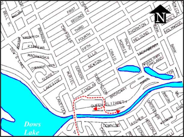
Figure 1: Study Area
ANNEX
6
Urban growth in the south of
the City has lead to increasing traffic volumes on these three local streets
and today, they are experiencing traffic volumes of over 400 vehicles in the
morning peak hour. Based on observed
driving patterns, most of these vehicles are non-local in nature. This lead the community to identify a series
of concerns, as noted below, over the impacts of this traffic on the overall
liveability along these streets:
·
Poor pedestrian environment caused by the continuous flow of traffic;
·
Safety concerns for school-aged children;
·
Poor driver behaviour including many who travel too fast, fail to stop
at stop signs, or drive in opposing lanes to circumvent a traffic queue; and,
·
Poor air quality from excessive traffic volumes.
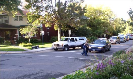
Figure 2: Photo of the intersection of Findlay and Broadway showing
a taxi illegally bypassing a
traffic
queue by driving in the wrong lane and the impact of this on the pedestrian
environment.
In order to reduce the traffic on Findlay
Avenue, Broadway Street and Torrington Place, the Glebe Traffic Plan made a
recommendation to prohibit northbound right turns onto Findlay. Realizing that this would simply shift the
problem onto the next available street, they further recommended that all
intersections between the Rideau Canal and Chamberlain Avenue be subject to the
same restriction, thereby ensuring that traffic remains on the arterial road
network and not on the local road network.
Since the problem was more pronounced in the morning peak period, and
since this was seen as the time period when community access was least critical,
the community plan recommended that this prohibition only be in place between
7:00 a.m. and 9:00 a.m., Monday to Friday.
Prohibiting the left-turns
to Madawaska Drive and Kippewa Drive will ensure that traffic does not start
using other local streets to avoid congestion at the Bronson/Carling Avenue
intersection.
ANNEX
6
Since right turns will be
prohibited at Findlay Avenue during the morning peak period, the third
northbound lane over the Canal Bridge would not be required for right turning
vehicles and can be converted to a shared bus-only/cycle lane. This will help improve transit travel on
Bronson
Avenue, particularly if
northbound traffic queues extend south of Findlay Street. Buses will be able to bypass these traffic
queues. This will be beneficial for
users of OC Transpo Route #4, which connects with the O-Train at Carleton
University. Not converting this lane
has potential implications for levels of compliance with the right-turn
restriction.
Reducing the turning radius at the Bronson/Findlay
Avenue intersection will also reduce vehicle turning speeds (during the times
of the day that vehicles are allowed to turn) and shorten the pedestrian
crossing distance at the intersection.
ANALYSIS
City staff were given the
mandate to carry out a technical review of the measures put forward in the
Glebe Traffic Plan and recommend which measures should be implemented and which
should not be implemented. The purpose
of this appendix is to report on the staff findings of the specific recommendation
as noted above.
In addition to the
recommendation brought forward by the GTP, staff carried out an assessment of
alternate solutions to that proposed in the Glebe Traffic Plan, and studied the
benefits and consequences of the GTP recommendations.
Alternate
Solutions
Several alternate solutions
were developed and evaluated, including:
·
Road Closures: A series of road
closures were considered that would block access to the Queen Elizabeth
Driveway from Torrington Place and Queen Elizabeth Place. This would reduce the desirability of using
Glebe streets as a link between Bronson Avenue and the Queen Elizabeth
Driveway. Staff did not consider this
idea to be viable since it would permanently remove all access to and from the
Queen Elizabeth Driveway between Fifth Avenue and Lakeview Terrace. It would also require excessive out-of-way
travel for many drivers and, hence, could result in increased infiltration
through the community;
·
One-way streets and/or traffic diverters: The designation of a series of one-way streets and traffic
diverters could be used to discourage through traffic movements between Bronson
Avenue and the Queen Elizabeth Driveway.
Staff rejected this idea due to the effects on local accessibility
within the community and the high likelihood of traffic volumes actually
increasing on certain local roadways;
·
Physical measures: Physical
measures such as speed humps or road narrowings were considered as a way to
address the problem in a less invasive manner. Although these measures can be
used to modify driver behaviour while travelling on a roadway, they are
unlikely to result in any significant reductions in volumes along these; and,
·
ANNEX
6
·
Change the limits of the right-turn prohibitions: for example, ban morning peak-period right
turns from Bronson Avenue at Findlay Street, Holmwood Avenue and Fifth Avenue
only; or between Findlay Avenue and Fifth Avenue only. A number of scenarios were considered and
rejected due to the increase in traffic that would result on the first street
that would not
·
have turn prohibitions. Table 1
illustrates the expected results of ending the right-turn prohibition at
various locations:
|
Table
1
Expected
results of ending the right-turn
prohibition
at various locations
|
|
Streets with NB
Right-turn Prohibition from Bronson Avenue
|
Effect
|
Only
Findlay Street.
|
Would
remove most traffic on:
·
Findlay
between Bronson Avenue and Broadway Street
·
Broadway
between Findlay Street and Torrington Place
Traffic
would reroute to Holmwood and access the Queen Elizabeth Driveway via
Torrington. This solution would simply displace the problem to a different
local street and is therefore not recommended.
|
|
Findlay
Street and Holmwood Street.
|
Would
remove most traffic on:
·
Findlay
Street between Bronson Avenue and Broadway Street
·
Broadway
Street between Findlay Street and Torrington Place
|
|
Findlay
Street, Holmwood/Fifth Avenues.
|
Would
remove most traffic on:
·
Findlay
between Bronson Avenue and Broadway Street.
·
Broadway
between Findlay Street and Torrington Place.
|
ANNEX 6
|
Findlay
Street, Holmwood Street, Fifth Avenue, Fourth Avenue, Third Avenue, Second
Avenue, and Glebe Avenue. (Note that First Avenue is a westbound one-way
street)
|
Would
remove most traffic on:
·
Findlay
Street between Bronson Avenue and Broadway Street.
·
Broadway
Street between Findlay Street and Torrington Place.
|
|
All
streets from Findlay Street to Renfrew Avenue and Imperial Avenue.
|
Would
remove most traffic on:
·
Findlay
between Bronson Avenue and Broadway Street.
·
Broadway
between Findlay Street and Torrington Place.
|
It was determined that turn restrictions
as recommended in the GTP were the best means of achieving the desired goals of
less traffic and higher liveability on Findlay Avenue, Broadway Street and
Torrington Place. Of particular
importance in considering this recommendation is that although the proportion
of non-local traffic using these local streets is high, the introduction of
turn-prohibitions will equally affect those people who have a legitimate reason
to be on these streets.
Traffic Impact Assessment of the GTP Recommendation
To adequately assess the
potential impacts of the prohibition, several redistribution scenarios were
identified and assessed. Based on this
analysis, the anticipated net change in vehicle volumes was predicted and is
shown in Figure 3 of document.
Predicting detailed traffic flows in a complex and congested network is
a difficult and inexact process at best.
Since the Findlay/Broadway/Torrington connection is used as a part of
the City’s arterial road network, it is difficult to determine where each
vehicle driver is coming from or going to or the route that they would take
should the restrictions be implemented.
It is recognized that some drivers will choose not to use Bronson Avenue
as their preferred route, but rather, will find another route entirely. An estimate of this was made in the traffic
prediction. However, the extent to
which this actually occurs could have a significant impact on the resulting
delays along the Bronson Avenue corridor.
ANNEX
6
It was predicted that the
following traffic-related impacts on the road network during the morning peak
period were most likely to occur:
·
Traffic volumes on the Findlay/Broadway/Torrington connection would
drop by about 400 vehicles per hour;
·
140 vehicles per hour that were using Findlay Avenue, Broadway Street
and Torrington Place as a link between Bronson Avenue and the Queen Elizabeth
Driveway will find alternate routes that do not include Bronson north of
Riverside Drive. Alternate routes may
include sections of Heron Drive/Walkley Road, Prince of Wales Drive, Riverside
Drive, Bank Street, Smyth Road/Main Street;
·
135 vehicles per hour that previously turned from Torrington Place onto
westbound the Queen Elizabeth Driveway were reassigned to the left-turn from
northbound Bronson to Carling Avenue;
·
50 additional vehicles per hour will use either Percy Street or Lyon
Street via Chamberlain to access the Glebe;
·
60 additional vehicles per hour will turn right on Sunnyside Avenue and
then left onto Bank Street. Some of these vehicles may turn onto Wilton Street
to access the Queen Elizabeth Driveway via Queen Elizabeth Place. The recent removal of the eastbound
left-turn lane at Sunnyside Avenue and Bank Street has caused eastbound traffic
queues to increase. The addition
traffic will further increase these queues;
·
60 additional vehicles per hour will use Colonel By Drive northbound
via Bronson Place.
·
Average travel times for northbound traffic travelling the 1.1 km on
Bronson Avenue between Findlay Avenue and Chamberlain Street is expected to
approximately double from 160 seconds per vehicle to 300 seconds per
vehicle. These additional delays would
affect 275 riders on 13 buses operating on OC Transpo Routes #4 and #41; and,
·
The effects to the Bronson Avenue/Carling Avenue intersection would be
considerable. It is currently heavily
congested during the morning peak hour with queues that extend past Fifth
Avenue. This situation will worsen due
to the volume of traffic that will be diverted as a result of the turn restrictions. It is expected that the average delay for
the vehicles travelling northbound through the Carling Avenue intersection
would increase from an average of 45 seconds per vehicle to 120 seconds per
vehicle, and the average delay to vehicles turning left at Carling Avenue would
increase from the observed 75 seconds per vehicle to 180 seconds per
vehicle. The additional left-turn
volume may also lead to a potential increase in collisions involving northbound
left-turning motorists who are already taking risks when turning onto Carling
Avenue. Mitigation of these safety
concerns is discussed below.
These predictions are based
on an assumed high level of compliance.
Experience would suggest, however, that some illegal right-turns can be
expected, ranging anywhere from 5% to as high as 30% or more, depending on
enforcement. The level of violation, of
course, influences the resulting traffic-related impacts of these restrictions.
ANNEX 6
Other benefits and concerns
of prohibiting the right turns are listed below in Table 2.
Table 2:
Benefits and Concerns of the Right-Turn Prohibition
|
Benefits
|
Concerns
|
|
·
Improves
quality of life for residents on Findlay Avenue, Broadway Street, and
Torrington Place.
·
Puts
arterial road traffic back onto the arterial roads
·
Improves
the environment for pedestrians and cyclists on local streets.
·
Negative
effects to transit would be somewhat mitigated by the conversion of the third
northbound lane on Bronson Avenue over the Bronson Bridge for bus/cycle use.
|
·
Increases
out-of-way travel for people whose destination is within the Glebe.
·
Potential
for violation of turn prohibitions that would lessen the effects of the turn
prohibitions.
·
Increased
traffic and delays on the various roadways can potentially lead to:
- Increased emergency
vehicle response times
- Increased difficulty for
pedestrians crossing Bronson
- Driver delay and
frustration due to reduced levels of service at intersections along
Bronson.
- Potential of increase in
greenhouse gases caused by increased vehicle idling on Bronson Avenue.
- Impacts on other community
streets including Sunnyside Avenue, Bronson Place, Percy Street and Lyon
Street.
- Reduced access to the
Queen Elizabeth Driveway during the AM Peak period.
- Increased potential of
collisions due to increased driver frustration.
|
Mitigation
The most significant of the negative impacts of the
right-turn prohibitions are the increased traffic volumes predicted at the
Bronson Avenue/Carling Avenue intersection.
This intersection is currently very congested during the morning
peak hour, forming long northbound queues of traffic, and experiences
an average of 19 collisions per year. The predominant collision pattern
is northbound left-turning vehicles conflicting with southbound through
vehicles. The current collision rate for this type of crash is
five times higher at this intersection than the average rate. This is further
exacerbated by the large number of southbound drivers running red lights as
evidenced in the high number of violations captured by the red-light camera at
this location. This intersection is currently under review in the Safety
Improvement Program to reduce the number of collisions and address pedestrian
concerns at the intersection. This review will also take into
consideration the City’s transit priority needs as Carling Avenue, between
Bayshore Drive and Bronson Avenue, is designated a Transit Priority Corridor in
the City’s Official Plan. The collision situation is expected to worsen
with implementation of the right-turn prohibitions
on Bronson Avenue as an additional 135 vehicles per hour will
turn left onto Carling Avenue from northbound Bronson Avenue. These additional vehicles will increase the
level of congestion leading to increased delays for motorists and may lead to
an increase in the number of collisions due to the increased risk that drivers
will accept as they turn left through the intersection. Remedial measures
may include shortening the pedestrian walking distances across the intersection
and creating a protected northbound left-turn phase. It is therefore recommended
that the implementation of the right-turn prohibitions on Bronson Avenue be
carried out
ANNEX
6
concurrently with the safety
improvements currently under review for the intersection of Bronson and
Carling Avenues to ensure that safety issues are addressed at this
intersection.
Monitoring
As recommended in the draft Area Traffic
Management Guidelines, all measures, when implemented, will be monitored and
evaluated to ensure that they are operating satisfactorily. One year after
implementation, traffic volume, traffic speed and compliance data will be
collected to assess the level of improvement that the project has achieved and
to assess secondary impacts that may have arisen. Data will be collected on all
roads affected or potentially affected by this Plan. Particular attention will
be paid to local and collector streets where increases in traffic volume
predicted including Sunnyside
Avenue, Bronson Place, Percy Street and Lyon Street. If unreasonable traffic
occur, measures for their mitigation will be developed.
Three years after implementation,
collision rates and patterns will be reviewed and compared with
pre-installation experiences.
Evaluation reports will be prepared at these two points and the results
will be made available. These reports
may recommend adjustments to the original plan if concerns have not been
adequately addressed or if unacceptable secondary impacts have occurred as a
result of the implemented measures.
OTHER ISSUES
Enforcement: Levels of police enforcement are likely to
have a direct effect on the levels of compliance, should the recommendations of
this report be approved.
Implementation: It is
recommended that implementation be carried out with as much advanced notice as
possible. This should include roadside
announcements (e.g. variable message signs) on Bronson Avenue indicating the
proposed changes that are put up at least two weeks before the changes, as well
as advertisements in The Citizen, Le Droit and the local community newspaper.
Timing of the implementation to coincide with the completion of the Bronson
Avenue / Carling Avenue reconstruction would be beneficial as the increased
congestion caused by the reconstruction would end at the same time as the
increase congestion due to the morning right turn prohibitions.
The turn restrictions can be implemented
before the implementation of the Bronson Avenue/Findlay Avenue intersection
radius reduction and the conversion of the third northbound lane on the Bronson
Bridge over the Rideau Canal provided that clear and adequate signage
indicating the turn restrictions is in place south of Findlay Avenue.
ANNEX 6
The cost of implementing
these measures will include:
·
The costs of the additional signage,
·
The cost of the physical changes of the curb radius at and removal of
the channelization at Findlay Avenue; and,
·
The cost of road painting associated with the conversion of the third
lane on the Bronson Avenue Bridge to a shared cycling/transit lane.
There will be some
additional maintenance costs associated with the recommendations related to
maintaining the line painting.
CONCLUSIONS
Based on the above analysis,
staff conclude that the recommendations as stated at the outset of this
appendix should be implemented. The reduction in curb radius at the
Findlay/Bronson Avenue intersection can be implemented at a later time, but the
other elements of the recommendation must be implemented as a “package” and
should not be separated.
It is important to carry out
the monitoring and evaluation program to assess the level of improvement that
the project has achieved and to assess any secondary impacts that may have
arisen one year and three years after implementation.
ANNEX 6