Report to/Rapport au :
Transit Committee
Comité
du transport en commun
and
Council / et au Conseil
30
July 2010 / le 30 juillet 2010
Submitted
by/Soumis par : Nancy Schepers, Deputy City Manager/Directrice municipale adjointe,
Infrastructure Services and Community Sustainability/Services d 'infrastructure
et Viabilité des collectivités
Contact/Personne
ressource: Vivi Chi, Manager/Gestionnaire, Transportation
Planning/Planification des transports, Planning and Growth Management/Urbanisme
et Gestion de la croissance
(613)
580-2424 x 21877, Vivi.Chi@ottawa.ca
|
|
Ref N°: ACS2010-ICS-PGM-0156
|
SUBJECT:
|
WEST TRANSITWAY CONNECTION (terry FOX drive
to fernbank road) pLANNING Study - functional design recommendations
|
|
|
|
OBJET :
|
ÉTUDE DE PLANIFICATION RELATIVE
AUX RACCORDEMENTS DU TRANSITWAY OUEST (DE LA PROMENADE TERRY FOX AU CHEMIN
FERNBANK) – RECOMMANDATIONS RELATIVES À L’ÉTUDE FONCTIONNELLE
|
REPORT RECOMMENDATIONS
That the Transit Committee
recommend Council:
1.
Approve the recommended functional design for the West Transitway
Connection from Terry Fox Drive to Fernbank Road;
2.
Direct staff to initiate the Transit Project Assessment Process based
on the functional design in accordance with the Ontario Environmental
Assessment Act (Regulation 231/08) including the preparation and filing of the
Environmental Project Report for formal public review and comment; and
3.
Direct staff to
initiate the property acquisition, subject to the completion of the
Environmental Assessment process and annual capital budget approval.
RECOMMANDATIONS DU RAPPORT
Que le Comité du transport en commun
recommande au Conseil :
1.
D’approuver l’étude fonctionnelle
recommandée concernant les raccordements du Transitway Ouest de la promenade Terry
Fox au chemin Fernbank;
2.
De superviser le personnel dans le cadre
du déclenchement du processus d’évaluation du projet de transport en commun en
fonction de l’étude fonctionnelle, conformément à la Loi sur les évaluations
environnementales de l’Ontario (règlement 231/08), ce qui comprend
l’élaboration et le dépôt du rapport de projet environnemental aux fins de
l’examen officiel et de l’émission de commentaires par le public; et
3.
D’enjoindre au personnel de commencer
l’acquisition de la propriété, sous réserve de l’achèvement du processus
d’évaluation environnementale et de l’approbation du budget d’immobilisation
annuel.
Executive
Summary
Assumptions and Analysis
This study was undertaken to
confirm the location of the future Transitway alignment and station locations through
Kanata West and Fernbank communities in order to allow development to
proceed. Previous planning work identified the need and rationale for the
Transitway, which was further confirmed in the 2008 Transportation Master Plan.
The corridor was identified by
the planning processes for the Kanata West and Fernbank Communities. Running
through the centre of the communities it will promote transit-oriented
development and encourage transit use. Within Kanata West, the Transitway
alignment was identified east of the North-South Arterial and the Fernbank Community
Design Plan placed it in the median of the roadway.
In total, 7.9 kilometres of
Transitway and eight stations are being proposed as part of this EA.
A key issue to be determined through
this study was transition from adjacent to median transit operation relative to
the proposed North-South Arterial. Options for the transition were
developed and analyzed. Option 2, with grade separations at Maple Grove Road and
Hazeldean Road, and a transition south of Hazeldean Station is
recommended. This Option has the highest capital cost, but most closely
resembles land use plans for Kanata West and Fernbank, provides superior
transit service for the long term, and has the least impact on traffic
operations at Hazeldean. The overall higher costs can be offset by
construction staging, with the grade separation being deferred until traffic
and transit demands warrant. The throw away costs would amount to $2 M in 2010
dollars, unescalated.
Next steps include starting the
formal EA process and completion of the EA in 2011, and initiating the property
protection process, subject to the provisions of the Planning Act, as
plans are received from adjacent developers.
Legal/Risk Management
Implications:
There are no Legal/Risk
Management impediments to implementing this Report's recommendation.
Technical Implications:
N/A
Financial
Implications:
The preliminary project cost
estimate to design and construct the West Transitway Connection from Terry Fox
Drive to Fernbank Road is approximately $425 M, unescalated. The following
provides a cost breakdown in 2010 dollars:
•
Construction – Terry Fox Drive to Fernbank Road (7.9 km) $260
M
•
Design, Project Management, Construction Administration (30%) $80
M
•
Property Acquisition $15
M
•
Project Contingency (20%) $70
M
$425
M
Funding for these works will be requested at the
appropriate time, as part of the annual Capital Budget process cycle to be
approved by Council.
Funding for the environmental assessment process is
provided for in Capital Account 902973 (Smart Growth Transit-Environmental
Assessment).
Public
Consultation/Input:
This study involved stakeholder
groups, including community organizations, property owners, businesses within
the study area, institutions, approval agencies and groups with a special
interest in the study. In addition to the Agency, Business and Public
Consultation Group meetings (two meetings each), three formal Public Open
Houses were conducted this year on 25 March, 02 June, and 22 June. A
project bulletin and comment-questionnaire was developed and distributed at
each of the open houses.
Information from the study has been posted on the City’s web
site:
(http://ottawa.ca/residents/public_consult/transitway_connections/index_en.html)
Consultation efforts will
continue as the study progresses to the EA phase of this project.
RÉSUMÉ
Hypothèses et analyse :
Cette étude a
été entreprise en vue de confirmer les emplacements du futur tracé du Transitway
et de ses stations au sein des collectivités de Kanata-Ouest et de Fernbank,
afin d’en faciliter le développement. Les travaux de planification antérieurs
ont permis d’établir le besoin et la raison d’être d’un Transitway, lesquels
ont par la suite été confirmés dans le Plan directeur des transports de 2008.
Les processus de
planification pour les collectivités de Kanata-Ouest et de Fernbank ont permis
de définir le couloir projeté. Traversant le centre des collectivités, il
favorisera un développement axé sur le transport en commun ainsi qu’une
utilisation accrue de ce service. À Kanata-Ouest, on a établi le tracé du
Transitway à l’est de l’artère nord-sud, tandis que le Plan de conception
communautaire de Fernbank le place au centre de la chaussée.
Au total, cette
évaluation environnementale (ÉE) vise 7,9 kilomètres du Transitway et huit
stations.
Dans le cadre de
cette étude, il a fallu examiner l’élément clé qu’est la transition entre la
circulation adjacente et la circulation médiane du transport en commun, par
rapport à l’artère nord-sud projetée. On a procédé à la conception et à l’analyse
de différentes options relativement à cette transition, à la suite desquelles
on a recommandé l’option nº 2, préconisant des carrefours à niveaux
différents sur les chemins Maple Grove et Hazeldean, ainsi que le déplacement
de la station Hazeldean vers le sud. Cette option présente les
dépenses en immobilisations les plus importantes; en revanche, il s’agit de
l’option la plus fidèle aux plans d’aménagement de Kanata-Ouest et de Fernbank,
en plus de garantir, à long terme, un service de transport en commun de qualité
supérieure et d’avoir l’incidence la plus faible sur la circulation au niveau
d’Hazeldean. Les coûts globaux plus élevés associés à cette option peuvent être
compensés par l’échelonnement des travaux, en retardant la construction du
carrefour à niveaux différents en fonction des besoins de la circulation et du
transport en commun. Il en résulterait des frais de deux millions de dollars
(dollars de 2010 non actualisés).
Incidences juridiques / concernant la gestion des risques :
La mise en œuvre
de la recommandation du présent rapport ne fait l’objet d’aucune contrainte
juridique ou de gestion des risques.
Incidences techniques :
S.O.
Répercussions financières :
Le coût
approximatif du projet préliminaire de conception et de construction des
raccordements du Transitway Ouest, de la promenade Terry Fox au chemin
Fernbank, s’élève à 425 millions de dollars, coût non actualisé. Les coûts affichés ci-dessous sont en dollars de 2010 :
•
Construction – de la promenade Terry Fox au
chemin Fernbank (7,9 km) 260 M$
•
Conception, gestion de projet et administration de
la construction (30 %) 80 M$
•
Acquisition de biens 15 M$
•
Fonds pour imprévus (20 %) 70 M$
425 M$
Le financement de ces travaux sera
demandé au moment opportun, pendant le cycle du processus du budget
annuel des immobilisations qui doit être approuvé au Conseil.
Le financement du processus d’évaluation
environnementale est assuré par le compte d’immobilisations no 902973
(études d’évaluation environnementale de la croissance intelligente du
transport en commun).
Consultation publique / commentaires :
Ont pris part à
cette étude différents groupes d’intervenants, dont des organismes
communautaires, des propriétaires fonciers, des entreprises du secteur visé par
l’étude, des institutions, des agences d’approbation et des groupes ayant un
intérêt particulier dans l’étude. En plus des réunions des groupes de
consultation publique, de consultation d’organismes et de consultation
d’entreprises (2 réunions chacun), trois séances portes ouvertes formelles ont
eu lieu au cours de l’année, soit le 25 mars, le 2 juin et le
22 juin. On a élaboré et distribué un bulletin et une fiche de
commentaires sur le projet à chacune des séances portes ouvertes.
Les renseignements concernant l’étude ont
été affichés sur le site Web de la Ville à l'adresse suivante :
(http://ottawa.ca/residents/public_consult/transitway_connections/index_fr.html)
Les efforts
consultatifs se poursuivront au gré de la progression de l’étude, jusqu’à la
phase d’évaluation environnementale (EE) du projet.
Les étapes à venir comprennent le
démarrage du processus officiel d’EE et sa finalisation en 2011, ainsi que le
déclenchement du processus de protection de la propriété, sous réserve des
dispositions de la Loi sur l’aménagement du territoire, dès la réception des
plans de la part des promoteurs du secteur.
BACKGROUND
Transportation system
improvements are crucial to accommodating the City’s population growth and the
associated increases in travel demand. Consequently, a Rapid Transit Network
was developed, and approved by Council in 2008, which includes new Light Rapid
Transit (LRT) lines and a number of extensions and additions to the existing
Bus Rapid Transit (BRT) Transitway system. In Kanata, two extensions of the
BRT network were included: a connection from Terry Fox Drive to Fernbank Road,
and a connection from Eagleson Road north along March Road to Old Carp Road.
Both corridors will be protected for conversion to LRT in the future. The two
corridors are shown in Figure 1.
The two segments were originally combined
into a single study based on previous work and based on the economies of
combining two smaller studies into a single larger one. The two segments are
independent, however as both are in Kanata, joint public meetings were
possible. As the study developed, additional corridor options beyond those
previously examined were identified for the March Road corridor, which required
additional work compared to the Kanata West corridor. Time to assess the
additional options made the joint schedule incompatible, as the Kanata West
section approval is required to address development applications and subdivision
plans currently underway.
This report focuses on the
functional design for the West Transitway (Terry Fox Drive to Fernbank Road) in
Kanata West. The functional design for the March Road section will be presented
to Committee and Council in 2011.
Figure 1: West Transitway Connection
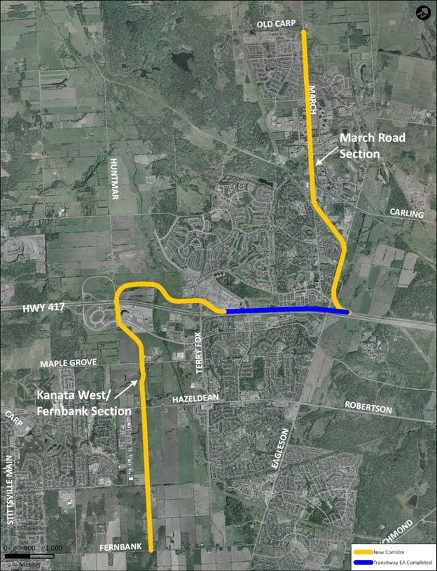
The West Transitway Connection,
Terry Fox Drive to Fernbank Road extends west of Terry Fox Drive and has a
southern extension that proceeds through development areas known as Kanata West
and Stittsville to the extent of the urban boundary at Fernbank Road.
In reconfirming the alignment
through the two development communities, consideration was given to satisfying
the need/opportunity for transit, as well as approved development plans and
approvals already in place under previous planning exercises in Kanata West. For
this reason, alignment alternatives were not re-assessed through Kanata West or
Fernbank development areas as transportation master plans exist that defined
these alignments. The rapid transit corridors identified in the Kanata West
and Fernbank Community Design Plans (CDPs) are being carried forward as part of
the West Transitway Connection project. This study examines, in further
detail, the corridor identified through those planning processes, to develop an
alignment, station locations and configurations for the West Transitway
Connection.
The environmental assessment will
be in accordance with the Transit Project Regulations (Ontario Regulation
231/08) which was enacted in 2008 and has strict timelines for the EA process.
The Regulation assumes that all detailed planning efforts (such as TMPs, CDPs,
functional design) are completed before the EA is initiated. This report
addresses the functional design for the transitway alignment.
DISCUSSION
Existing Community Planning Efforts:
The Kanata West development
concept plans (Figure 2), shows the Transitway located generally through the
centre of the community, and adjacent to the North-South Arterial from Maple Grove Road to Hazeldean Road. Stations were shown at Carp River, Campeau Drive,
Scotiabank Place, Maple Grove Road and Hazeldean Road. A planned station
at Didsbury Road is east of the development area, but was indicated on earlier
plans for the Kanata Centrum area.
As noted, the Kanata West
Transportation Master Plan (June 2006) identified the general alignment of a
rapid transit corridor west of Kanata Centrum through the Kanata West
Development Area to Hazeldean Road. The alignment for rapid transit to extend
from Hazeldean Road south to Fernbank Road was generally identified in the
Fernbank Community Design Plan (CDP) as shown in Figure 3.
Figure 2: Kanata West Concept
Plan
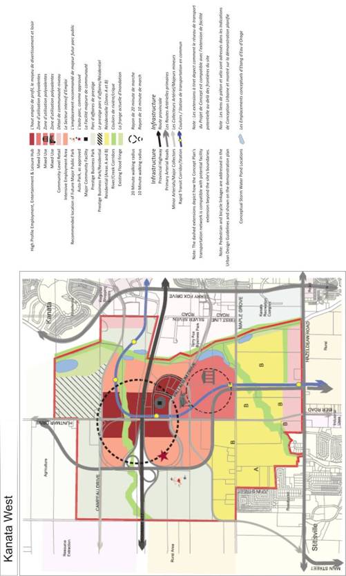
Figure 3: Fernbank Community
Design Plan
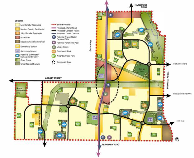
The Fernbank Community Design
Plan also evaluated and identified a transit corridor. The Fernbank
Transportation Master Plan and the CDP show the Transitway in the median of the
North-South Arterial with major stations to be located at Hazeldean Road,
Abbott Street and Fernbank Road.
The Kanata West and Fernbank
plans also illustrate the location and proposed use of the lands within their
plan areas. Transitway stations have been located at major arterial road
crossings, development nodes or recreational sites, recognizing that further
Environmental Assessment work would be undertaken to identify the alignment and
station locations and to complete the functional design and impact assessment
of the Transitway.
Project Need
The West Transitway Connection
(Terry Fox Drive to Fernbank Road) will:
•
Respond to growth pressures by providing improved transportation in the
study area;
•
Contribute to keeping Ottawa a liveable and economically viable city by
providing a valuable facility for structuring and achieving land use,
environmental, and social objectives; and
•
Expand the City’s rapid transit network to accommodate existing and
future travel demand in Kanata and to key regional centres.
The West Transitway Connection
offers significant opportunities for compact, mixed-used development in the
vicinity of stations. Defining and protecting the Transitway alignments and
station locations allows for transit-oriented development in the appropriate
forms at the right locations. As development proceeds, by providing an
efficient, reliable and safe transit system will encourage desirable shifts to
travel by transit in the Mixed-Use Centres, Employment Areas and Enterprise
Areas.
This project is highlighted in
the TMP: the portion from Terry Fox to Scotiabank Place is a Phase 2 project,
Phase 1, Increment 3.
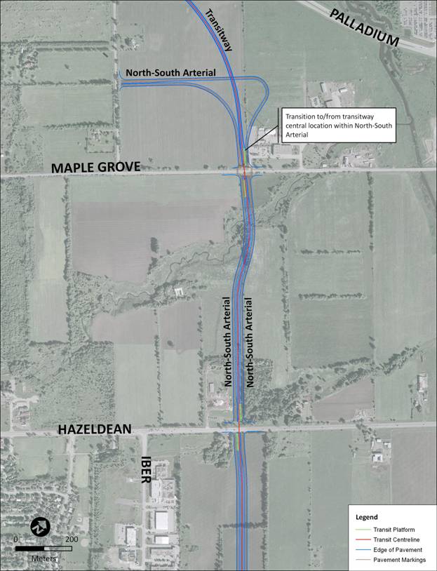
Evaluation of Alternative Alignments
Three alignment options were
developed for the Transitway as it transitions from adjacent to the North-South
Arterial at the northern half of the study area, to the median of the Arterial
in the southern half. The details and assessments of these transition options are
summarized below.
Option 1: Transition
between Maple Grove Road and Hazeldean Road
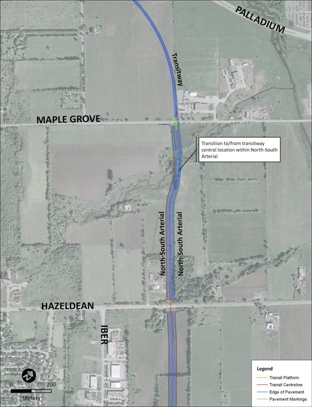
Option 2: Transition south
of Hazeldean Road
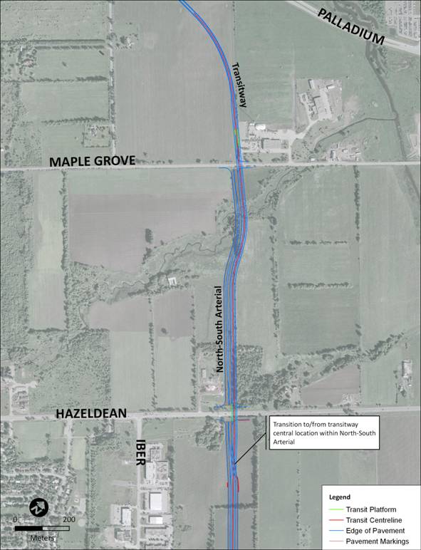
Option 3: Transition north
of Maple Grove Road
The
evaluation of the transition alternatives was based on the impact to the
existing environment with input from the public. Criteria included:
•
Compatibility with Existing and Future Road System
•
Ridership and Transit Operations
•
Geometrics
•
Compatibility with Existing and Future Communities
•
Effects on Noise, Air Quality and Vibration
•
Soil and Groundwater Considerations
•
Effects on Natural Features
•
Constructability
•
Capital Cost
•
Land Acquisition Requirements
The evaluation of transition
alternatives is summarized in Table 1 and includes the indicators used to
evaluate each of the corridor alternatives.
Table 1: Evaluation of Corridor
Options
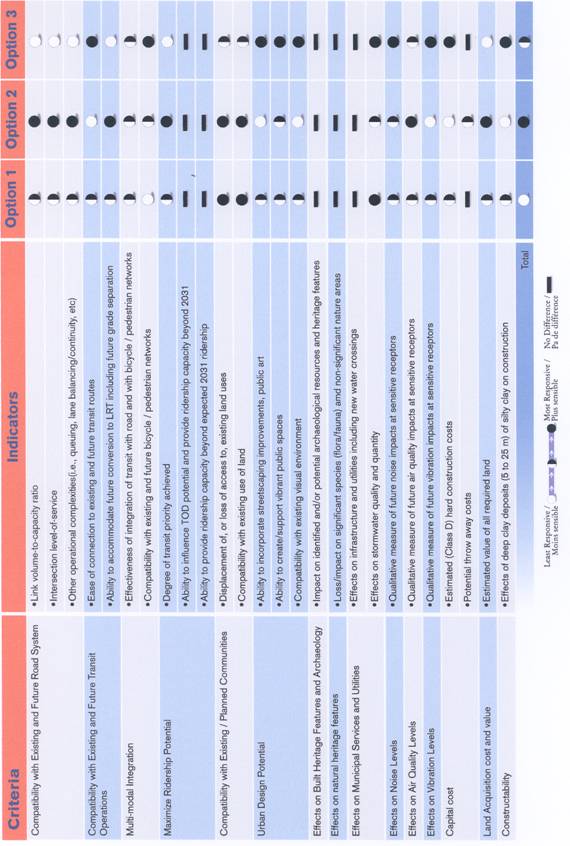
 The evaluation results show that
Options 2 and 3 were ranked similarly with the primary difference relate to
grade separation. Option 2 provides grade separation of the Transitway at
Hazeldean Road and Maple Grove Road, resulting in better traffic operations for
all vehicles and transit. Option 3 is at grade at Hazeldean Road and Maple
Grove Road, which results in poor performance for traffic operations at the
intersections, particularly the intersection at Hazeldean.
The evaluation results show that
Options 2 and 3 were ranked similarly with the primary difference relate to
grade separation. Option 2 provides grade separation of the Transitway at
Hazeldean Road and Maple Grove Road, resulting in better traffic operations for
all vehicles and transit. Option 3 is at grade at Hazeldean Road and Maple
Grove Road, which results in poor performance for traffic operations at the
intersections, particularly the intersection at Hazeldean.
Option 2 is recommended because
it:
•
Is most compatible with approved land use plans for the Kanata West and
Fernbank communities,
•
Provides superior transit service for the long term,
•
Provides the least impact on traffic operations at Hazeldean Road, and
•
Provides opportunities for phased construction.
While Option 2 is approximately $95
million greater in cost, the implementation of the Transitway grade-separation
can be done in stages. The North-South Arterial will be constructed in
sections from south to north to accommodate development, however, more
northerly portions could be constructed for bus use only, or widened from an
initial two lanes to the ultimate four lanes and provide transit use in mixed
traffic or in dedicated bus lanes. Once the arterial reaches capacity, the
grade-separated Transitway would need to be constructed to improve transit
service and reduce congestion. The throw away costs would amount to $2 M in
2010 dollars, unescalated.
The geotechnical investigation
undertaken as part of the CDP and this project indicates that there are poor to
very poor soil conditions along most of the corridor. Grade raise limits for
local roads and development have been respected and the costs for the project
reflect the need for deep pile foundations for the elevated station and
Transitway construction and the need for specialized light-weight or ultra
light-weight fill at the transitions.
A description of the functional
design is provided below and illustrated in Document 1.
Recommended Alignment (7.9 km total)
Centrum – Scotiabank Place:
2.8 km
Beginning at Terry Fox Station,
the proposed Transitway is located along the north side of Highway 417. West
of Terry Fox Station, the Transitway follows the curve of the westbound Highway
417 off-ramp at Terry Fox Drive. The Transitway then passes under Terry Fox
Drive before reaching Didsbury Road, where a typical 4-lane station will be
provided. The alignment will require the closure of Goulbourn Forced Road at
the Transitway to allow for the extension of Earl Grey Drive under Terry Fox
Drive to serve the local neighbourhood.
After crossing Didsbury Road at
grade, with a controlled intersection, the Transitway curves to the northwest
before entering Carp River Station. West of the Carp River Station, the
alignment crosses over the Carp River on a new bridge structure, before curving
to the left and entering Campeau Station. Both the Carp River and Campeau
Stations will be typical 4-lane Transitway Stations. At the east end of Campeau
Station there will be a second road crossing to provide access to the
development lands south of the Transitway and north of Highway 417. The
sidewalks on the roadway will provide the access to the Station. West of
Campeau Station, the Transitway curves towards the south and passes over
Feedmill Creek before rising to cross over Highway 417, east of Huntmar Drive.
South of Highway 417, the Transitway remains on an elevated structure located
on the east side of Huntmar Drive, and west of Scotiabank Place. A station
serving Scotiabank Place will be provided between Cyclone Taylor Drive and Palladium Drive. This station will need to serve large volumes of passengers before and
after events. By‑pass lanes and platforms are supported with adequate
circulation capacity to manage operations.
Scotiabank Place – Fernbank
Road: (5.1 km)
South of Scotiabank Place, the elevated
Transitway passes over Palladium Drive before descending back to grade. South
of Palladium Drive, the Transitway proceeds towards the corridor for the future
North-South Arterial. The Transitway will be located along the east side of
this road and continue south before rising onto a structure to cross over Maple Grove Road. At Maple Grove Road, a station will be provided on the elevated
structure, with pedestrian access from the north side of the street. The
station was shown conceptually during the public consultation and has now been
located to serve both Maple Grove Road and the potential soccer complex to the
northeast. By-pass lanes will be provided through the station to meet
operational needs. South of Maple Grove Road, the Transitway descends back to
grade and passes over Poole Creek on a new bridge structure.
North of Hazeldean Road, the
alignment rises onto another elevated structure to cross Hazeldean Road. A
station will be provided on the elevated structure. The station is positioned
directly over Hazeldean Road to provide good access to both the north and south
sides of the road. By‑pass lanes are included through the station to meet
the operational needs. Two park and ride facilities will be provided at
Hazeldean Station, located north (325 spaces) and south (325 spaces) of
Hazeldean Road, and linked by the station.
South of Hazeldean Station, the
elevated structure will cross the northbound lanes of the North‑South
Arterial, descend back to grade and continue south in a dedicated transit
facility located within the median of the North-South Arterial. At Abbott
Street, an at-grade station will be provided, consisting of staggered bus
platforms within the median. A third central by-pass lane has been included
and will provide a by-pass immediately adjacent to each platform, transitioning
through the intersection with Abbott Street. A Park and Ride Facility (250
spaces) will be provided on the southeast corner of the Abbott/North-South
Arterial intersection. South of Abbott Street, the alignment continues
at-grade within the median of the North-South Arterial until reaching Fernbank
Road, where a terminus station and Park and Ride Facility (200 spaces) will be
provided. As a terminal station, the platforms may be located in the Park and
Ride area, or split by direction such that one platform remains in the median
and the other is located in the Park and Ride. The arrangement will need to be
revisited if the Transitway is extended further south in the future.
Implementation/Staging Opportunity
The TMP indicates that the
construction of the West Transitway Connection (Terry Fox Drive to Fernbank Road)
is expected to happen in two phases:
•
The section from Terry Fox Drive to Scotia Bank Place is included in
Phase 1, Increment 3; and
•
The section from Scotiabank Place to Fernbank Road is included in Phase
2.
Scotiabank Place Station will
serve as the terminus for initial construction of the West Transitway
Connection. Terminal facilities consisting of a turnaround loop, operator
facilities and lay-by spaces for buses will need to be provided at this
location in order to support regular transit operations as well as additional
service requirements for events at the stadium.
Staging of construction south of Scotiabank Place could
include:
•
Constructing portions of the North-South Arterial not already in place
and using them as dedicated transit lanes, or opening them for general traffic
and operating bus service in mixed traffic;
•
Widening portions of the North-South Arterial to allow buses to operate
in mixed traffic or in dedicated shoulder lanes; and ultimately
•
Constructing the adjacent Transitway and grade separations when demand
dictates.
Constructing the project in
stages as described above allows the City to defer the majority of the costs
associated with the structures in excess of $95 million of expenditure until
congestion dictates the requirement for a grade-separated transit facility.
Major activities for the initial stage include the
construction of:
•
The paved running way, including embankments, drainage, road base,
asphalt and lighting;
•
Stations, including the platforms, shelters, buildings and connections
to the roads, sidewalks and bicycle pathways;
•
Bridge structures, including a major bridge over Highway 417 near Scotia Bank Place; and
•
Park and Ride facilities at key stations including, parking areas,
access points and pedestrian access to the adjacent station.
Park and Ride Lot Locations
In addition to confirming the
alignment and station locations, the study also examined the potential for four
Park and Ride locations, including two at Hazeldean Road, one at Abbott Street
and one at Fernbank Road. None of the locations presented critical impediments
to development as a Park and Ride. As a result, the park and ride space
allotment was distributed amongst all four locations to best capture ridership
and reduce localized land use impacts. The four Park and Ride Facility
locations are shown on the plans in Document 1.
Approximately 650 park and ride
spaces will be provided in the vicinity of Hazeldean Station in two lots. One
lot will be located on the north side of Hazeldean Road on land acquired by the
City for the original terminal station site. Access will be provided directly
off Hazeldean Road and could also be integrated with the access provided by the
adjacent development. The second lot would be on the south side of Hazeldean
Road and would be approximately the same size depending on property
negotiations with the current land owner. Access could be directly off
Hazeldean Road or integrated with the adjacent development. Providing two lots
at this location will improve access and egress queuing and provide for
improved access to the station.
The park and ride lot at Abbott Street
will be dual purpose, serving commuters during the weekdays and providing
access to the adjacent neighbourhood park and Trans-Canada trail at other
times. This lot would be constructed under the hydro towers. The Fernbank
Road lot would provide a location for rural transit users and those close to
the south edge of the urban area to access the Transitway. The lot and station
are located on the north side of Fernbank Road inside the urban boundary. Land
for this site was identified in the Fernbank CDP.
Analysis of Environmental Effects
Localized, site specific impacts
are summarized below including recommended mitigation measures:
Transportation
The Extension of Earl Grey Drive:
In order to accommodate the
grades in the vicinity of Terry Fox and Highway 417 it is necessary to close
Goulbourn Forced Road at the intersection with the Transitway. To facilitate
continued movement and access to existing and planned development, Didsbury
Road will be extended south and then east along the southern edge of the MTO
Works Yard (adjacent to Highway 417) and north towards the Transitway. Earl
Grey Drive will be extended under Terry Fox and back to the Centrum
development, allowing for a better level of service to the area and improving
traffic circulation patterns.
Station Connection to Scotiabank Place:
The Transitway is grade separated
across Highway 417. The alignment and station are located to the west side of
Scotiabank Place (adjacent to Huntmar Road), with pedestrian access connecting
to the second level of the stadium. Internal access and egress patterns within
the stadium will need to be altered to accommodate an efficient connection to the
Transitway station.
A Pedestrian Crossing at Abbott Street:
The Trans-Canada Trail crosses
the Fernbank CDP area and intersects with the adjacent North‑South
Arterial and the Transitway. The Fernbank CDP recommends protecting for a
grade‑separation of the Trans-Canada Trail at this location. Given the
very poor soil conditions at this location, the intersection of the North-South
Arterial and Transitway with Abbott Street and the hydro lines immediately
south of Abbott Street, the only feasible alternative for a grade separation is
to provide an underpass for the Trail. The functional plan would accommodate a
crossing of the Trail under the Transitway. If grade separation is not
feasible or is cost prohibitive, alternate protection for an at-grade crossing
of the Trail will need to be provided.
Traffic Management, Access and Pedestrian Control Plan:
A traffic management plan would
be developed during the detailed design/pre-construction phase and implemented
in the construction phase. Traffic detours and lane reductions will be
required during construction of the segregated transitway. Traffic detours or
lane reductions may be required at Terry Fox, Goulbourn Forced Road, Didsbury
Drive, Campeau Drive, Huntmar Drive, Scotiabank Place, Palladium Drive, Maple Grove Road, Hazeldean Drive and Fernbank Road. The Contractor will be required to
develop a traffic management plan for all detours which shall be monitored by
the City.
Natural Environment
Fisheries Compensation Plan for the Crossing of the Carp River and Poole Creek:
Within the Kanata West
development area, the Transitway has been considered within the nine roadway
crossings proposed to be constructed over the next 20 years. These proposed
works may result in the Harmful Alteration Disruption and Destruction (HADD) of
fish habitat. Through negotiations with the Department of Fisheries and Oceans
it has been agreed that the ecological restoration works associated with the
Carp River Restoration will be "credited" against the future proposed
crossings and that this is an acceptable project for utilizing the habitat
banking concept.
Butternut Tree Survey and Management Plan for Identified
Sites:
Butternut trees have been
identified in the area. They are a protected species due to the presence of a
canker which is a disease that is drastically reducing the population. The MNR
has a recovery and protection plan in place provincially and mitigation is
possible. Prior to construction of the Transitway a survey of the butternut
trees should be conducted and a site specific mitigation plan developed. Part
of the considerations is that the timing for construction is far into the
future and any butternuts present today may potentially not survive at time of
Transitway construction.
Erosion and Sediment Control Plan:
The purpose of the erosion and
sediment control plan is to determine the degree of erosion and sedimentation
that would occur under normally anticipated weather conditions during the life
of the project, and to develop and implement mitigative measures to control any
unforeseen areas determined to be predisposed of the problem. These elements
would be identified in the detailed design process and construction
specifications. The plans will be prepared to the satisfaction of the regulatory
authorities including the City and the Conservation Authority.
Landscaping Plan:
A landscape plan will be prepared
during the detailed design and pre-construction phase and implemented during
the construction phase for the median and roadside areas identified in the
functional plan. An allowance for landscaping has been included in the cost
estimate.
Emergency Response Plan During Construction:
The preparation of an emergency
response plan by the Contractor shall allow for full emergency services access
during the construction period, such that at any time there is a method to
access all land uses in the event of an emergency. The plan should also
include provisions for providing temporary services to end uses in the event of
a construction related service outage or other service disruption. A spills
response and reporting process should also be included in the plan and adhered
to by the Contractor. In the event of a spill, the Ministry of the Environment
is to be contacted, spills and discharges of pollutants or contaminants will be
contained immediately, and clean up should be initiated quickly to ensure
protection of the environment.
Management of Excess Materials:
Construction waste types may
include the following: soil, rock, concrete, asphalt, natural wood and other
vegetation, sod, steel and other metals, etc. General management and disposal
of construction waste by the Contractor will be similar to the guidelines and
practices of the Ontario Provincial Standards Specifications, and must conform
to Ontario's Environmental Protection Act and associated regulations, and, if
applicable, to the Ontario Dangerous Goods Transportation Act and the Canadian
Transportation of Dangerous Goods Act.
Social Environment
Stage Two
Archaeological Assessments Adjacent to the Corridor from Hazeldean Road to
Abbott Street:
Areas of archaeological potential
were identified in the Fernbank CDP area. If development has not occurred in
advance of the Transitway construction, a Stage 2 Archaeological Assessment
would need to be undertaken.
Property Impact
Property acquisition requirements
have been identified along the corridor. Some of the lands have been acquired
through the site plan process, while others are awaiting applications from land
owners. Some of the identified lands will need to be acquired by the City to
support the project. Costs associated with acquiring property and property
rights on which to build or provide construction easements for the construction
of the West Transitway includes right‑of‑way preparation, legal and
appraisal services and land survey.
CONSULTATION
This study involved stakeholder
groups, including community organizations, property owners and businesses
within the study area, institutions, approval agencies and groups with a
special interest in the study. In addition to the Agency, Business and Public
Consultation Group meetings (two meetings each), three formal Public Open
Houses with presentation were conducted this year on 25 March, 02 June, and 22 June.
A project bulletin and comment‑questionnaire was developed and
distributed at each of the open houses. A summary of the comments and
responses are included below.
Contact with Aboriginal
Communities (Algonquins of Ontario and Metis) were made initially to inform
them of the project and identify opportunities for involvement. In accordance
with the Provincial EA process, the Aboriginal Communities will be given an
opportunity to review the draft EA and provide input into the process following
the Notice of Commencement. No comments have been provided to date.
Information from the study has
been posted on the City’s web site: (http://ottawa.ca/residents/public_consult/transitway_connections/index_en.html).
Consultation efforts will continue as the study progresses to the EA phase of
this project.
Public Open House#1
The purpose of the first public
open house was to present existing conditions and alternative alignment options
for two section of the West Transitway Connection, the March Road Corridor and
the connection south from Terry Fox Drive to Fernbank Road via Scotiabank
Place. A total of 32 people attended the Open House, the majority of the
participants originated from the Beaverbrook Community. The majority of the
comments related to the segment of the West Transitway between March Road and
Kanata Centrum which has already been approved through a prior environmental
assessment process. Similarily, comments relating to the March Road Corridor
will be reviewed during the environmental assessment for that corridor which
will be presented to Council seperately at a later date. A portion of the
comments related to existing and future road and transit operations that are beyond
the scope of this study (such as Highway 417 operation, and current bus
services).
Specific concerns relating to the
Transitway portion between Terry Fox Drive and Fernbank Road include noise,
vibration and soil suitablity for the transit facility, Park and Ride Facility
locations and preference for a grade-separated solution.
Noise and Vibration:
Comments related to noise and
vibration are common to this class of project. An Environmental Noise, Air
Quality and Ground Vibration Study was completed for the project. The
assessment procedure included a combination of of computational modelling based
on current environmental data, physical site measurements, and interpretation
of gathered data. The existing conditions data is compared to established City
guidelines and provincial guidelines set forth by the Ministry of the
Environment. The report concluded that noise levels at existing or possible
future sensitive points of reception are within acceptable limits.
Soil Suitablilty:
Soil conditions in the area vary
from poor to very poor. The clay soils are susceptible to settlement, and the
area CDPs indicate minimal grade changes for all development to minimize
potential settlements. As a result, structures and embankments for the
Transitway will need to rely on deep piles for foundations and use of light
weight or ultra light weight fill materials, increasing the capital cost of the
project. These conditions have been accounted for in the cost estimate.
Park and Ride Facility Locations:
It was suggested that a Park and
Ride Facilty be located at Fernbank Road for the convenience of Stittsville
residents. A Park and Ride Facility in this location was included as part of
the evaluation and recommendation.
Grade-Seperation:
A preference was noted that a
grade-seperated solution should be implemented at the onset to ensure a
cost-effective alternative and one that would be truly rapid transit. The
recommended alignment includes grade-separated solutions where possible, and
includes potential staging strategies to minimize initial capital costs and
provide for future grade separations when traffic and transit volumes warrant.
Natural Environment:
The protection of Poole Creek and
its inhabitants as well as wildlife in the area was cited as a concern,
particularly during construction. The functional plan identifies requirements
for conservation and protection of aquatic habitats and their inhabitants.
Design:
General design comments were
received with respect to facility design including transit station design and
park and ride lots and will be incorporated into future detailed design work
including such elements as: station safety, landscaping, and lighting.
Public Open House #2
The purpose of the second public
open house was to present the evaluation of alignment alternatives and evaluate
the preliminary preferred alternative solution. The event specifically dealt
with the West Transitway Connection between Terry Fox Drive and Fernbank Road.
The open house included a presentation to the community. A total of 15 people
attended with the majority representing the communities of Kanata South and
Stittsville.
Concerns specific to the project
included noise, the ability to incorporate a multi-use pathway over the
Queensway at Scotiabank Place, and the plan’s alignment with the City's
environmental stategy, the objectives of the TMP and NCC’s sustainability
objectives.
Multi-Use Facility:
The Official Plan, the TMP, and
the Pedestrian and Cycling plans require a multi-use pathway to be constructed
adjacent to transit facilities where feasible. While this can be achieved for
a significant proportion of the Transitway, the structure over Highway 417 and
the area adjacent to Scotiabank Place is not well connected to adjacent
facilities and would essentially confine pedestrians or cyclists to the
Transitway, thus reducing the integration with the community and adjacent
facilities. The pathway should be developed along arterial roadways through
this area.
Station and Park and Ride
locations have been integrated to make the experience of walking or cycling
both convenient and positive in a way to enhance the overall experience of
getting to and from the transit stop or station in accordance with the
Transit-Oriented Development (TOD) guidelines.
Sustainability Objectives:
The West Transitway Connection
between Terry Fox Drive and Fernbank Road implements the objectives of the
City’s Official Plan and its supporting plans.
Public Open House #3
A subsequent open house was
convened at the request of the Ward Councillor on 22 June 2010 for the
community of Stittsville. This event again focused on the portion of the
Transitway between Terry Fox Drive to Fernbank Road. A total of 14 people
attended with the majority representing Stittsville. One written comment was
received, expressing a preference for LRT over BRT for this project. A verbal
comment was received with respect to protection of prime agricultural land.
COMMENTS BY THE WARD
COUNCILLOR(S)
Councillor Wilkinson supports the recommendations in the
report.
Councillor Qadri
is aware of this report.
Councillor Brooks -
“Move ahead, you have my concurrence.”
LEGAL/RISK
MANAGEMENT IMPLICATIONS
There are no legal/risk
management impediments to implementing this report's recommendations.
CITY STRATEGIC
PLAN
The
recommendation contained herein aims to support the following Strategic
Directions adopted by Council on 11 July 2007:
A1 Improve the City's transportation network to afford ease of
mobility, keep pace with growth, reduce congestion and work towards model split
targets.
B1 Attain transit goals (30 per cent modal split) by 2021.
E6 Require walking, transit and cycling oriented communities
and employment centres.
F4 Ensure that City infrastructure required for new growth is
built or improved as needed to serve the growth.
TECHNICAL IMPLICATIONS
N/A
FINANCIAL IMPLICATIONS
The preliminary project cost
estimate to design and construct the West Transitway Connection from Terry Fox
Drive to Fernbank Road is approximately $425 M, unescalated. The following
provides a cost breakdown in 2010 dollars:
•
Construction – Terry Fox Drive to Fernbank Road (7.9 km) $260
M
•
Design, Project Management, Construction Administration (30%) $80
M
•
Property Acquisition $15
M
•
Project Contingency (20%) $70
M
$425
M
Cost estimates will form part of
the Long-Range Financial Plan, which will be tabled later this year. Funding
will be requested, at the appropriate times, through the capital budget
process.
Funding for the environmental assessment process is
provided for in Capital Account 902973 (Smart Growth Transit-Environmental
Assessment).
SUPPORTING DOCUMENTATION
Document 1 West
Transitway Connection (Terry Fox Drive to Fernbank Road) Functional Design
Plans
DISPOSITION
Following Committee and Council
approval of the functional design, Planning and Growth Management will
undertake the following:
·
Initiate and complete the formal Environmental Assessment process
using the functional design to define the undertaking and file the
Environmental Assessment Report with the Ministry of the environment in
accordance with Ontario EA Regulation 231/08 for transit project.
·
Initiate the property protection process, subject to the
provisions of the Planning Act as plans are received from adjacent developers
·
Initiate the property acquisition process, subject to subsequent
year capital funding requests, and the completion of the EA process.