M
E M O / N O T E D E S E R V I C E
|
|

|
To / Destinataire |
Chair
and Members of the Transit Committee / Président et
membres du Comité des services de transport en commun |
File/N° de fichier: ACS2009-ICS-TRA-0013 |
|
From / Expéditeur |
Nancy Schepers, Deputy City Manager/Directrice municipale
adjointe, Infrastructure Services and Community Sustainability/Services d’infrastructure et Viabilité des
collectivités |
Contact / Personne-ressource : Alain Mercier, General Manager/Directeur
général
Transit Services/Services du
transport en commun |
|
Subject / Objet |
Strategic Plan for Bus Connections with Rail Line / Plan stratégique pour les correspondances entre autobus et train leger |
Date: 27 November 2009 |
SUMMARY
This memo presents a plan, at the
concept level, for the way that bus routes would be changed to connect with the
new rail line once it is built and open. The construction of the rail line
allows for much of the current bus operation within downtown to be replaced by
train operation in the new tunnel. The removal of longer-distance bus routes
from downtown, in turn, allows for the reorganization of local bus routes
within downtown to improve connections and to meet other identified priorities.
The downtown part of this plan would
ensure that all customers on local bus routes in downtown would have a good
connection to the rail line, a good connection to major downtown destinations,
and a good connection to other local bus routes in downtown. It would also
substantially reduce the number of buses operating on Rideau, Albert, and
Slater Streets, and it would maintain most of the current transit-related
pedestrian flow through the Rideau Centre.
Under this plan, bus routes from
points near or east of Blair Station would end there, where customers would
transfer to the train. Bus routes from points near or south of Hurdman Station
would end there. Bus routes from points west of Tunney’s Pasture Station would
end there, except that a limited number of buses from Kanata and Barrhaven
would continue on-street east of there, to provide connections to the O-Train
at Bayview Station and to provide service via LeBreton Station to the major
employment areas in Gatineau.
This plan for bus route connections with
the rail line is being used to develop the functional requirements for stations
on the rail line. Input from transit customers and residents will be sought
through the consultation process for the Downtown Ottawa Transit Tunnel
Environmental Assessment, through comment on ottawa.ca and octranspo.com, and
through the normal Transplan consultation and approval process in the years
before the rail line opens. Approval by
Council of the particular route changes would be part of the normal Transplan
process in future years.
DIRECTION FROM COUNCIL
In its approval on May 27, 2009, of the
corridor alignment and station locations for the environmental assessment of
the downtown rail line (Downtown Ottawa Transit Tunnel Planning and
Environment Assessment Study Update, ACS2009-ICS-PLA-0069) Council directed
staff to evaluate and report on several matters related to bus operation once
the rail line is built and open.
The pertinent elements of the
decision by Committee and Council were:
3. That in consultation
with the Ward Councillor, staff investigate options with the goal to minimize
bus traffic along Albert Street as it passes through the LeBreton Flats and
report back to Transit Committee.
4. That Transit Services staff be directed
to develop for the approval of Committee and Council a conceptual transit plan
for surface operations;
And that the following principles be incorporated into the terms of
reference of the plan:
a)
The
recognition of the continued importance of preserving the economic vitality and
viability of the Rideau commercial district
b)
The
importance of transit service – both access from all areas of the City and the
details of operations – to support this economic vitality and viability
c)
The
need for convenient connections from the surface transit service to the
underground light rail line
d)
The
need for continued transit service on Mackenzie King Bridge to maintain a
pedestrian flow through the Rideau Centre and nearby businesses and to maximize
existing infrastructure investment
e)
The
need for substantial reductions in the number of buses operating on Rideau
Street and on Albert and Slater Streets to improve the general environment on
those streets and for businesses along those streets
f)
The
possible need for transit priority measures or physical modifications to
streets or stations to allow the recommended plan to be implemented
g)
The
need for convenient connections for customers travelling from points west of
Tunney's Pasture to downtown
h)
The
need for convenient connections for those customers travelling from points west
of Tunney's Pasture to points served by the O-Train from Bayview Station and
points served by OC Transpo buses into Gatineau from LeBreton Station
And that staff be directed to interpret Recommendations 3 and 4 (as
amended) in such a way that the conceptual surface transit plan provides a
balance between customer convenience and community impact for bus service on
Scott and Albert Streets between Holland and Empress Streets.
DISCUSSION
The new rail line would provide the
primary transit service to and from downtown Ottawa, and would replace much of
the current bus operation. The entire transit system would be designed and
operated in such a way that the rail line is its spine. Planning the future
route network will be a task that continues from now, through the opening of
the first increment of the rail line, and on into the future as the City’s
rapid transit network expands. Planning of a strategic or conceptual nature
will often be required many years before the final service plans are developed
and approved, in order to provide input to the design of the rail stations and
in order to answer general questions about the future operation of the OC
Transpo system.
There are four elements of the
future transit network that are described in this memo:
- Bus
route connections at the Rideau Centre and at downtown rail stations;
- Bus
route connections at Blair, St. Laurent, and Hurdman Stations;
- Bus
route connections at Tunney’s Pasture Station; and,
- Connections
with Gatineau and Carleton University.
This memo provides information on
the current strategy for the bus routes connecting with the rail line in these
four areas, and in particular to show how the directions that were provided by
Council on some specific issues have been incorporated into the plan. These are
the bus operating plans that are providing input to the functional design of
the rail line and its stations. The route planning, however, is not complete,
and will be refined based on the outcome of the functional design and the
environmental assessment process and based on ongoing changes in travel needs
over the years before the rail line opens. The eventual route changes to
integrate the bus routes with the rail line would be part of the normal
Transplan consultation and approval process in the years before they are made.
Bus Route Connections at the
Rideau Centre and at Downtown Rail Stations
Staff have designed a future bus
route configuration for downtown that responds to the direction from Council to
follow three objectives:
- A
very good quality of transit service for transit customers;
- A
pattern of pedestrian flow that supports the downtown economy; and,
- Improved
urban conditions with reduced volumes of bus operation on Rideau, Albert,
and Slater Streets.
While the new rail line would
replace most of the current bus operation within downtown, there remain major
parts of central Ottawa which would be served predominantly by bus service –
examples are Vanier, Lower Town, Sandy Hill, and the Glebe. The routes serving these areas need to be
designed to provide connections to major downtown destinations, to the rail
line, and to each other.
The plan that has been developed for
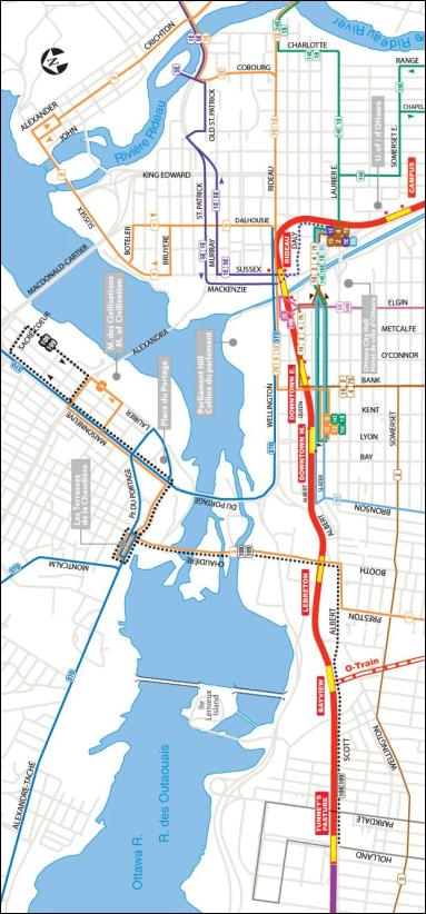
bus routes in downtown is attached in Document 1 and explained in Document 2.
The plan achieves the three objectives outlined above and achieves the
directions of Council.
All bus routes provide convenient connections
All bus routes in downtown would
connect with the rail line at one or more downtown stations. There would be
consistent connection points for buses heading to common destinations, to keep
the services easy to understand and to use. The map in Document 1 shows six
groups of routes in downtown.
- Routes
7E, 9, and 12 on Rideau Street, connecting with the rail line at Rideau
Station and making secondary connections at Downtown East and Downtown
West Stations;
- Routes
1E and 5E on Sussex and Mackenzie, connecting with the rail line at Rideau
Station;
- Routes
14E, 16E, and 18 on Laurier Avenue in Sandy Hill and on Mackenzie King
Bridge, connecting with the rail line at Rideau Station and making
secondary connections at Downtown East and Downtown West Stations;
- Routes
5S and 14W on Elgin Street, connecting with the rail line at Rideau
Station and also within a short walk of Downtown East Station;
- Routes
1S, 2, 4, and 7S on Bank Street, Queen Street, and Mackenzie King Bridge,
connecting with the rail line at Downtown East Station and making a
secondary connection at Rideau Station; and,
- Route
85 on Bronson and Albert/Slater, connecting with the rail line at Downtown
West Station and making secondary connections at Downtown East Station and
Rideau Station.
All bus routes in downtown would
connect with each other, either at common stops, at intersections, or through
rail stations.
Bus routes serve important downtown destinations
All bus routes in downtown would
serve the major employment and shopping areas within downtown, including the
Rideau Centre. As today, some customers would need to walk or to transfer to
the rail line or another bus route to reach a particular location within
downtown.
Pedestrian traffic at the Rideau Centre is maintained
The
number of OC Transpo customers who walk to, from, or through the Rideau Centre
would be at approximately 85 per cent of the levels that would be experienced
if the current routes were to remain unchanged. This meets the objective of
Council to sustain pedestrian traffic in this area, without causing
inconvenience to transit customers.
The
distribution of the pedestrian traffic within the Rideau Centre would be
different from today, however. OC Transpo-related pedestrian traffic would be
at approximately 60 per cent of the current levels at the Mackenzie King Bridge
end of the Rideau Centre and at approximately 105 per cent of the current
levels at the Rideau Street end.
OC Transpo bus operations on Rideau, Albert, and Slater are reduced dramatically
The number of OC Transpo bus trips
operating on Rideau Street between Sussex and Nicholas would be at
approximately 30 per cent of the levels that would be experienced if the
current routes were to remain unchanged. This would reduce the intrusion of
transit operations in this area and would allow for improved urban conditions.
(Reductions in the number of STO buses operating on Rideau Street will be
possible based on the outcome of the forthcoming interprovincial rapid transit
strategy study and the decisions that are made by Council and by other bodies
following that study.)
The number of OC Transpo bus trips
operating on Albert and Slater Streets between Elgin and Lyon would be at
approximately one-third of current levels, and west of Lyon at approximately
five per cent of current levels. This would reduce the intrusion of transit
operations in this area and would allow for improved urban conditions.
No major road work is required
Staff evaluated whether any substantial
physical changes would be needed to roads or to transit facilities within
downtown to support the new downtown route plan. No new bus lanes would be
required, and in particular no changes would be needed to the section of Waller
Street between Rideau Street and the Mackenzie King Bridge.
The reduction in the number of buses
operating on downtown streets may also create opportunities for road changes
that are not currently feasible. The current bus lanes on Albert and Slater
Streets and on the Mackenzie King Bridge would be able to be redesigned, and
some sections may no longer be needed, because of the reduced number of buses
operating in them.
It is important for the continued
success of the transit system in carrying customers to, from, and through downtown
that the reduction in the number of buses operating on downtown streets not
result in a reduced competitive position for transit. Any road change that is
being considered for downtown as a result of the rail project should be
evaluated to ensure that capacity and convenience for auto traffic is not
unduly increased.
Facilities are required for customers to wait and for buses to turn around
The entrances to the downtown
stations of the rail line will be designed to accommodate many needs, including
convenient connections to the bus routes within downtown. Space will be
designed and developed for customers to wait for buses at these stations.
Locations for buses to stop, turn
around, and wait for their next departure time would be required at three locations:
the current Transitway both north and south of Laurier Avenue; a location on
Albert or Slater near Lyon, perhaps using part of the current bus lane; and on
Elgin Street at Confederation Square, perhaps using the current space allocated
for tour buses, which could perhaps be moved to space made available by the
removal of the bus lanes on Albert and Slater. Further planning on how best to
meet these operational requirements will be carried out along with the rail
line project.
Next steps
This route plan meets the objectives
established by Council. It will serve as the long-term plan for bus routes in
downtown and it will be used as one foundation for the design of the rail line
and its downtown stations. A map and description of the downtown route plan
will be made available on the web for customers to review and to provide
comments. If there are opportunities to introduce any of the features of the
new route plan before the opening of the rail line, staff will present those
for consultation and approval as part of the normal Transplan planning process.
Bus Route Connections at
Blair, St. Laurent, and Hurdman Stations
Blair Station would be the eastern hub
Blair Station would be the primary
connection with the new rail line for services from the east. All current
express and rapid transit routes from Orléans would end at Blair Station, and
customers would transfer there to the rail line. Due to the short distance
between Orléans and Blair Station, the express and local routes within Orléans
would be combined so that there would be a single route operating from each
area within Orléans directly to Blair Station. There would continue to be local
service linking areas within Orléans, as the current Route 130 does today.
Blair Station would also be the connection point between the rail line and
local routes in its vicinity.
Blair Station is being designed to
conveniently accommodate all of the customers who would be changing to or from
the rail line or transferring between bus routes there, and to also provide
space for buses to stop, turn around, and wait for their next departures.
Customers alighting from buses would be able to move directly down from the bus
platform to the train platform using stairs, escalators, and elevators, and
because the station will be designed as an all-fare-paid area, they would not
need to show a transfer or pass to change between buses and trains. Drawings of
Blair Station are provided in the report on the functional planning of the rail
line. Further information will be available on the operating procedures at
Blair Station as the detailed design of the rail line and of the future bus
route network continues.
Place d’Orléans Station would be
less of a focal point for local bus operations than it is now. As almost all services to or from different
parts of Orléans would connect with the rail line at Blair Station, Place
d’Orléans Station would be used primarily by customers who are travelling to or
from the commercial areas nearby or to or from the park and ride lot. Route 95
would no longer exist in its present form. With all areas of Orléans connected
directly to the rail line at Blair Station, the replacement for Route 95 would
operate only as frequently as required to provide the additional capacity
needed between Blair Station and Jeanne d’Arc, Place d’Orléans, and Trim
stations in Orléans.
St. Laurent and Hurdman Stations would be major transfer points
St. Laurent Station would serve a
role similar to its current one, as a transfer point between the rail line and
local routes in its vicinity. No substantial changes would be required to the
current upper-level platform of the station. Some routes which now join the
Transitway at St. Laurent Station and end at Hurdman Station would instead end
at St. Laurent Station.
Hurdman Station would be the primary
connection with the rail line for services from the Southeast Transitway and
from locations such as Elmvale, Alta Vista, and the hospital complex on Smyth
Road. All current direct-to-downtown and rapid transit routes from these areas
would end at Hurdman Station, and customers would transfer there to the rail
line.
Hurdman Station is being designed to
conveniently accommodate the customers who would be transferring there. There
would be a single bus platform, from which customers can walk a short distance
to stairs, escalators, and elevators, which would rise to the elevated train
platform. Because the station will be designed as an all-fare-paid area,
customers would not need to show a transfer or pass to change between buses and
trains. Customers who start their trip at Hurdman Station would pay their fare
before entering the station. With the reconfiguration of the area now used for
bus operations on the Transitway, there are means to improve walking access to
the station and improved access for cars and taxis that are picking up or
dropping off customers.
Bus Route Connections at
Tunney’s Pasture Station
Tunney’s Pasture Station would be the temporary western hub
Tunney’s Pasture Station would be
the primary connection with the new rail line for services from the west. All
current express and rapid transit routes from Barrhaven, Nepean, Kanata, and
Stittsville would connect at Tunney’s Pasture Station, and most customers would
transfer there to the rail line. Tunney’s Pasture Station would also be the
connection point between the rail line and nearby local and main line routes.
The role of Tunney’s Pasture Station
will change twice in the forthcoming years. When the first phase of the rail
line opens, Tunney’s Pasture Station will be the western terminal of the rail
line, and the eastern terminal for buses from all areas to the west. As such,
it will temporarily need to accommodate a high volume of bus operations. When
the rail line is extended further west to Baseline Station, the nature of
Tunney’s Pasture will change again, and it will serve a role similar to today,
as a connection point for bus routes in the neighbouring areas and on Holland
Avenue and as a walk-in station for customers working or living in the area.
Tunney’s Pasture Station is being
designed to serve its temporary role as a major transfer station, but also to
be converted back to an on-line station. The station would accommodate all of
the customers transferring and would have room for buses to stop, turn around,
and wait for their next departure. In order to allow operations at the station
to flow smoothly and for customers transferring in the afternoon to be carried
as effectively as possible, new operating procedures will be developed as the detailed
design of the station and of the future bus route network continues.
Connections with Gatineau and
Carleton University
Connections to Gatineau from the east via downtown or LeBreton Station
With the opening of the rail line,
customers travelling from points in downtown and east of downtown would have
two ways to travel to Gatineau. Customers who are heading for all major
employment locations in Gatineau would be able to change to STO bus service at
Rideau Station or elsewhere downtown. This connection would replace the current
service provided by OC Transpo Routes 27 and 40. Customers who are heading for
points at or near les Terrasses de la Chaudière would also be able to transfer
at LeBreton Station to OC Transpo bus service across the Chaudière Bridge,
which would replace the current service on Routes 8, 88, and 105.
Further changes to this connection
will be possible based on the outcome of the forthcoming interprovincial rapid
transit strategy study and the decisions that are made by Council and by other
bodies following that study.
Connections to Gatineau from the west via Tunney’s Pasture and LeBreton Stations
During the years that the rail line
ends at Tunney’s Pasture Station, direct bus service would be provided during
peak periods from Kanata and Barrhaven to Gatineau, in order to avoid the need
for customers to transfer to the rail line at Tunney’s Pasture Station and to
change again to a bus just two stations later, at LeBreton Station. These
routes are shown as Routes 108 and 109 on the map in Document 1. They would
operate on the Transitway to Tunney’s Pasture Station and after stopping there
would continue via Scott Street and Albert Street to LeBreton Station, and then
across the Chaudière Bridge into Gatineau. This service would not be required
once the rail line is extended to Baseline Station.
The direct service from Kanata and
Barrhaven would operate only during peak periods. At all times of the week, OC
Transpo Route 3, which provides north-south service on Preston Street, would be
extended north on Booth Street via LeBreton Station and into Gatineau,
replacing the current Route 8.
Further changes to this connection
will be possible based on the decisions after the interprovincial rapid transit
strategy study.
Bus operations on Scott and Albert
After
the rail line is extended to Baseline Station, the operation west of the bus
turning and waiting area at City Centre Avenue would not be required, as the
direct service would end. Bus operation on Albert Street between City Centre
Avenue and Booth Street would continue, in order to provide the required
transit capacity across the Chaudière Bridge. Further changes could be possible
based on the decisions made after the interprovincial rapid transit strategy
study.
Connections to Carleton University
Customers travelling from points in
downtown and east of downtown on the rail line would make their connections to
Carleton University either through Bayview Station, to the O-Train (or its
future replacement), or at Hurdman Station, to buses from there to the
university.
Customers travelling from Barrhaven,
Kanata, and other locations west of Tunney’s Pasture Station would make their
connections to Carleton University by bus to Bayview Station and then by
O-Train. They would be able to use the bus trips that are extended through to
Gatineau by alighting from those buses at Bayview Station and changing to the
O-Train there.
CONSULTATION
Staff have also briefed Councillors
Bédard, Holmes, Leadman, and Wilkinson on the details of this plan and on the
results of the consultations noted above.
Input from transit customers and residents will be possible during the consultation process for the Downtown Ottawa Transit Tunnel Environmental Assessment, through comment on ottawa.ca and octranspo.com, and as part of the normal Transplan consultation and approval process in the years before the rail line opens.
Original signed by
Nancy
Schepers
:ps
ATTACHMENTS
Document 1 Downtown
and LeBreton Area Route Plan
Document 2 Downtown
Route Summary
Document 3 Downtown
Pedestrian and Bus Numbers