Report
to/Rapport au :
Comité de
l'urbanisme
and Council / et
au Conseil
30 April 2012
/ le 30 avril 2012
Submitted
by/Soumis par : Nancy Schepers, Deputy City Manager/Directrice
municipale adjointe, Planning and Infrastructure/Urbanisme
et Infrastructure
Contact
Person/Personne-ressource : John Smit, Manager/Gestionnaire, Development
Review/Examen des projets d'aménagement, Planning and Growth
Management/Urbanisme et Gestion de la croissance
(613) 580-2424, 13866 John.Smit@ottawa.ca
|
SUBJECT: |
ZONING - 2781, 2791,
2797 Baseline Road |
|
|
|
|
OBJET : |
ZONAGE – 2781, 2791 et
2797, chemin Baseline |
REPORT RECOMMENDATION
That
the Planning Committee recommend Council approve an amendment to the Zoning
By-law 2008-250 to change the zoning of
2781, 2791, 2797 Baseline Road 2704, 2706, 2724 and 2734 Draper Avenue from
R5A[1700] S247 (Residential Fifth Density Subzone A, Exception 1700, Schedule
247 Zone) to R5A[1700] S247, 282-h (Residential Fifth Density Subzone A,
Exception 1700, Schedules 247 and 282 Holding Zone) as detailed in Document 2
and shown on Document 1, 3 and 4.
RECOMMANDATION DU RAPPORT
Que le Comité de recommande au Conseil d’approuver
une modification au Règlement sur le zonage 2008-250 afin de changer la désignation
de zonage des 2781, 2791 et 2797, chemin Baseline ainsi que des 2704, 2706,
2724 et 2734, avenue Draper de R5A[1700] S247 (Zone résidentielle de densité
cinq, sous-zone A, exception 1700, annexe 247) à R5A[1700] S247, 282-h (Zone résidentielle de densité cinq, sous-zone A,
exception 1700, annexes 247 et 282, aménagement différé), comme il est expliqué en
détail dans le document 2 et indiqué dans les documents 1, 3 et 4.
BACKGROUND
The following supplement report has
been prepared in response to a direction to staff at the April 10, 2012 Planning
Committee meeting. The Committee
provided direction to staff with respect to performance standards that were to
be included within a Zoning By‑law amendment for the subject lands that
captures a revised development concept. In compliance with this direction, this
report recommends appropriate zoning amendments to ensure the orderly
development of the site in a manner consistent with the revised development
concept. The revised development concept
produced is the result of consultation and discussion with staff, the Ward
Councillor and the public to address concerns which were raised from recent
applications for Site Plan Control and a City-initiated Zoning By-law
amendment.
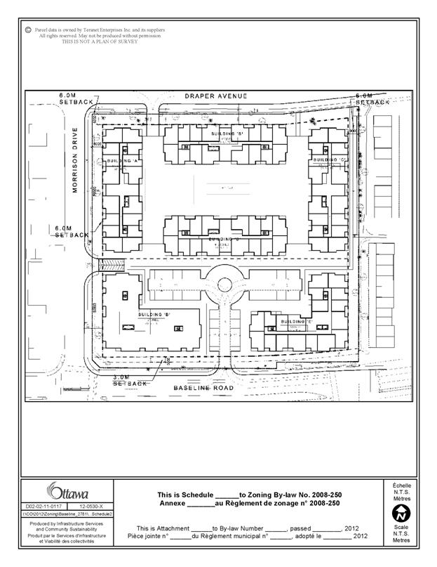
The revised development concept
proposes six buildings on the site as shown on Document 4. The new buildings are orientated around the
perimeter of the site to create a continuous built form along the Baseline
Road, Morrison Drive and Draper Avenue frontages which is consistent with the
existing built form in the area. The
buildings range in height from 17 metres (4.5 storeys) on the northern portion
to 18 metres (5 storeys) on the southern portion abutting Baseline Road. On the northern portion of the site, the
internal area is programmed with passive uses such as a large courtyard and pedestrian
walkways while the interior area of the southern portion of the site is proposed
as a surface parking area. Limited
commercial uses would be permitted for the two buildings fronting along
Baseline Road with the recommend zoning also permiting outdoor commercial
patios within a specified area. The majority
of the required parking for the site will be provided through one level of
underground parking that would be accessible from Morrison Drive and Draper
Avenue. One access is proposed from
Baseline Road that would service visitor and commercial parking.
Purpose of Zoning Amendment
The recommended zoning will implement a revised development concept for
the subject property. This new
development proposal represents a departure from the original concept plan
approved on September 17, 2010. The recommended
by-law would amend the existing zoning by adding additional site-specific performance
standards and schedules that will capture and regulate the revised development concept
as shown on Document 4.
Existing Zoning
The site is zoned Residential Fifth
Density Exception Zone - R5A[1700] S247. The current zoning permits a range of
residential uses such as multiple attached dwellings and low and high-rise
apartments. Schedule 247 sets out the
maximum permitted height over the site, and areas where no principle building
is permitted above grade. The exception
also sets out site-specific provisions with respect to minimum landscaping
requirements and the size and location for additional permitted uses which include
uses such as office, retail, restaurant, personal service and convenience
store. The existing zoning does not have
a performance standard that regulates the amount of development permitted on
site through either a unit cap or maximum gross floor area.
Proposed Zoning
The proposed zoning, as shown on Document 2, will modify the existing
exception by adding additional site-specific performance standards that will
limit the maximum number of residential units permitted to 400 units with a
maximum permitted Gross Floor Area (GFA) of 34,000m2. These limits are consistent with unit count
and GFA represented in the initial development scheme as assessed through staff
report ACS2009-ICS-PGM-0129. The
proposed zoning will also replace the schedule 247 which regulates the maximum
permitted height, minimum yard set-backs and locations where an outdoor patio
is permitted. The permitted heights are being significantly reduced from a
maximum of 39 metres (12 storeys) that was permitted under the previously
approved zoning to 18 metres (5 storeys).
Required parking for the site has been reduced from 1.2 spaces to
1.0. The required rate for visitor
parking remains unchanged at 0.2 spaces per dwelling unit. The amendment will also introduce a holding
provision that will prohibit development on the site until such time as an
application for Site Plan Control has been approved. The holding provision will also require that
any phase of development be consistent with the revised development concept as
shown on Document 4.
DISCUSSION
Official Plan
Strategic Directions
To meet the challenge of managing
growth, the City will direct development to locations within the urban area
where services already exist or where they can be provided efficiently. Within
the lands designated General Urban Area, opportunities for intensification
exist and will be supported.
The subject property is designated as General Urban
Area in the Official Plan. The General
Urban Area permits the development of a full range and choice of housing types
in combination with conveniently located employment, service and uses to
facilitate the development of complete and sustainable communities. The City promotes infill development and
other intensification within the General Urban Area in a manner that enhances
and complements the desirable characteristics and ensures the long-term
viability of a community.
The introduction of a low-rise
apartment buildings provides for a variety of housing forms for various incomes
and life cycles, and is considered appropriate and consistent with the policies
of the Official Plan.
Compatibility Considerations
Compatible development means
development that, although not necessarily the same as or similar to existing
buildings, nonetheless enhances an established community and co-exists without
causing undue adverse impact on surrounding properties. Section 2.5.1 sets out broad design
objectives as qualitative statements on how the City will influence the
evolution of the built environment.
These objectives are focused on enhancing the sense of community and
maintaining places with their own distinct identity, providing quality public
and private spaces through development, creating places that are safe,
accessible and are easy to get to and move through, and ensuring that new
development respects the character of existing areas. Design principles further
describe how each of the design objectives may be achieved.
The proposed development achieves the
design principle of considering the street as a public space with a
well-designed streetscape which includes landscaping and a continuous built
edge facing the street that is void of surface parking and multiple private
driveways. The limited access points to
the site and underground garage is consistent with the existing built form
along Morrision Drive. The proposed
development also achieves the design principles of ensuring that development
respects the character of existing areas by transitioning the building height
to be consistent with existing built forms.
To this end, the proposed building heights schedule as shown on Document
3 which provides for height transitions downwards to the north, with the taller
building elements located on the southern portion of the site with heights up
to five stories permitted.
Section 4.11 of the Official Plan, as
well as the City’s Urban Design Guidelines, provide further direction on design
and compatible development. Objective criteria that can be used to evaluate compatibility include:
height, bulk or mass, scale relationship, and building/lot relationships, such
as the distance or setback from the street, and the distance between buildings.
An assessment of the compatibility of new development will involve not only
consideration of built form, but also of operational characteristics, such as
traffic, access, and parking. The
following is an analysis of the applicable criteria in Section 4.11 of the
Official Plan.
Transportation and Access
An updated traffic impact study will
be required through the Site Plan Control process to determine any potential
roadway modifications which may be required to support the interim and end
state development program. A traffic
study was submitted in support of the previous Site Plan Control applications
which proposed over 590 units. Through
the review of the study, staff concluded that the existing network was able to
accommodate such a level of development with only minor roadway
modifications. With the reduced level of
development, as recommended, it is reasonable to assume that any potential
modification will be minimal.
Nonetheless, the traffic impacts of the revised development will be
fully assessed through the Site Plan Control process.
Parking
Required parking for the site will
largely be provided underground with minimal surface parking which is only
accessible form Baseline Road. An
entrance to the underground garage will be provided along Morrison Drive and
Draper Avenue. Owing to the orientation
of the proposed buildings, a limited amount of surface parking will be visible
from Baseline Road.
Sunlight
A sun-shadow study was prepared for
the revised submission which modelled the expected shadows to be cast
throughout the year. The proposed
shadows are expected to have minimal impacts on the abutting properties. The revised building heights have reduced the
shadowing impacts.
Building Profile and Compatibility
Integrating taller
buildings within an area characterized by a lower built form is an important
urban design element when considering an application for intensification.
Development proposals will address the issues of compatibility and integration
by ensuring that an effective transition in built form is provided between
areas with different development profiles.
Transitions in built form will serve to link proposed development with
both planned, as well as existing uses, thereby acknowledging the planned
function of an area.
The community surrounding the site is
characterized as a stable low-profile community along Morrison Drive and Draper
Avenue and the abutting streets. The
existing built form along Morrison Drive and Draper Avenue consists of two-storey
multiple attached dwellings and single-storey detached dwellings. Multiple attached dwellings are arranged as
both street townhouses as found along Morrison Drive, and within clustered
developments as found to the east of the site.
Permitted heights within the area range from 8 metres to north, 9.5
metres to the west, and 11 metres to the east.
In a response to providing an
appropriate transition to create a compatible form of development, the tallest
building elements have been located on the southern portion of the site
abutting Baseline Road transitioning downward to the north. The overall massing
of the program for the site has been significantly revised from the original
proposal with a reorganization of the tallest built elements from the centre of
the site towards Baseline Road. The
original buildings proposed at the southwest and southeast corner of the site
have been reduced from eight (27 metres) and six storeys (21 metres)
respectively to five storeys (18 metres).
With respect to privacy impacts, the
units abutting the surrounding streets are designed to address the street, with
private amenity space located within the interior of the site which is thereby
effectively screened by the building. This
built form is consistent with dwellings in the area which have their primary amenity
space in the rear of their lots, buffered by the dwelling. The condition along the eastern interior side
yard is unique to the site as it abuts the rear-yard of the neighbouring townhouse
development, but again as these units are designed with the principle amenity
space within the interior of the site, any potential impacts of privacy would
be minimal as it is reasonable to expect a patio or porch may be designed into
the elevations abutting the streets or eastern property limit. Such a feature would create a minimal if any
undue adverse impact.
Concurrent
Application
An application for Site Plan Control (File
D07-12-11-0167) is currently on hold as requested by the applicant.
RURAL IMPLICATIONS
There are no rural implications
associated with this report.
CONSULTATION
Notice of this application was carried out in
accordance with the City's Public Notification and Consultation Policy. Details
of the consultation can be found in Document 5.
COMMENTS BY THE WARD COUNCILLORS
The Councillor is aware of the staff
report.
LEGAL IMPLICATIONS
Should this recommendation be adopted
and the resulting by-law be appealed to the Ontario Municipal Board, it is
anticipated that such hearing could be conducted within staff resources.
RISK MANAGEMENT IMPLICATIONS
There are no risk management
implications associated with this report.
FINANCIAL IMPLICATIONS
There are no direct financial
implications. In the event of an appeal, staff resources would be utilized to
defend Council’s decision.
ACCESSIBILITY IMPACT
ENVIRONMENTAL IMPLICATIONS
There are no environment implications
associated with this report.
TECHNOLOGY IMPLICATIONS
There are no technology implications
associated with this report.
TERM OF COUNCIL PRIORITIES
The
application is consistent with the Planning and Growth Management priority
which encourages the infill and intensification of lands designated General
Urban Area.
APPLICATION PROCESS TIMELINE STATUS
This application was processed by the "On Time
Decision Date" established for the processing of Zoning By-law amendment
applications.
SUPPORTING DOCUMENTATION
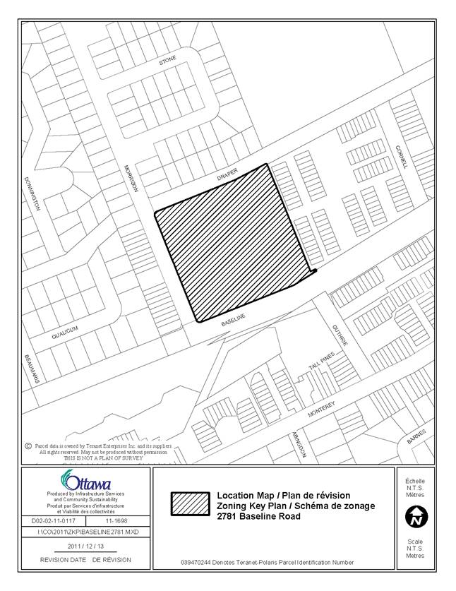
Document 1 Location Map
Document 2 Details of Recommended Zoning
Document 3 Revised Schedule 247
Document 4 Revised Concept Plan
Document 5 Consultation Details
DISPOSITION
City Clerk and Solicitor Department,
Legislative Services to notify the owner, applicant, OttawaScene Canada Signs, 1565 Chatelain Avenue, Ottawa, ON K1Z 8B5, Ghislain Lamarche, Program Manager,
Assessment, Financial Services Branch (Mail Code: 26-76) of City Council’s decision.
Planning and Growth
Management
to prepare the implementing by-law, forward to Legal Services and undertake the
statutory notification.
Legal Services to forward the
implementing by-law to City Council.
LOCATION MAP DOCUMENT
1
DETAILS OF
RECOMMENDED ZONING DOCUMENT
2
1. The
subject property as shown on Document 1 is rezoned from R5A[1700] S247 to
R5A[1700] S247, 282-h
2. Section
239 - Urban Exceptions will be amended by replacing exception 1700 with a new
exception 1700 with provisions similar to the following:
Additional Land Uses Permitted
bank machine
convenience store
instructional facility
office
personal service business
recreational and athletic facility
restaurant
retail food store
retail store
Provisions
- maximum number of dwelling units:
400
- maximum gross floor area: 34 000 m2
- yard setbacks are as per Schedule
247
- maximum building heights as per
Schedule 247
- a floor or storey of a building that
accommodates amenity space such as a gym and party room but does not include
dwelling units may project above the height limit to a maximum of 4.0 metres
- minimum required parking for
residential use: 1.0 parking space per dwelling unit
Despite Table 164B Endnote 1 the
additional land uses permitted subject to:
i) the maximum gross leasable floor area for
each individual tenancy is 325.15 m2
ii) the total maximum gross leasable floor area
is 1115 m2
iii) the uses are only permitted on the ground
floor of buildings that are consistent with Buildings E and F as shown on the
concept plan noted as Schedule 282
iv) - despite clause 85(3)(a) an outdoor
commercial patio is permitted anywhere within the shaded area shown on Schedule
247
Holding Provisions
Land Uses Prohibited
- all uses until such time as the
holding provision is removed, except those uses in place on the date of the
enactment of the by-law.
Provisions
- a Site Plan for the overall
development that reflects the development concept shown on Schedule 282 has
been approved and where phased development is proposed, the details for the
Phase to be developed has received approval through a formal site plan approval
process either as part of the initial site plan for the entire development or
through a revised site plan application where each phase reflects a development
program that is consistent with and will provide for implementation of the
development concept shown on schedule 282.
- details related to all required site
accesses have been confirmed and approved by the General Manager, Planning and
Growth Management for both interim, where phased development is proposed, and end state conditions. These details will identify any roadway
modifications that may be required as part of the overall development program
and for interim/phased developments.
3. Part
17 - Schedules is amended by:
(a) replacing Schedule 247 with a new
Schedule 247 as shown on Document X
(b) adding a new schedule as shown on
Document X as Schedule 282.
REVSIED SCHEDULE 247 DOCUMENT
3
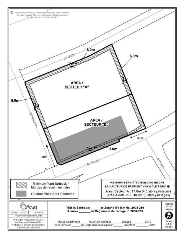
REVISED
CONCEPT PLAN DOCUMENT
4
CONSULTATION
DETAILS DOCUMENT
5
NOTIFICATION
AND CONSULTATION PROCESS
Upon the
deferral of the original City-initiated rezoning, the applicant began
consulting with staff and the Ward Councillor with respect to a revised
development concept for the site. During
this time, the Councillors office had organized and attended meetings with
members of the community regarding the revised development concept it an effort
to respond to concerns raised through the recent applications for Site Plan
Control.