Report to/Rapport au :
Planning and Environment Committee
Comité de l'urbanisme et de
l'environnement
31 July 2009 / le 31 juillet 2009
Submitted by/Soumis par : Nancy Schepers, Deputy City Manager
Directrice municipale adjointe
Infrastructure
Services and Community Sustainability
Services d'infrastructure et Viabilité des
collectivités
Contact
Person/Personne-ressource : John Smit, Manager/Gestionnaire, Development
Review-Urban Services/Examen des projets d'aménagement-Services urbains,
Planning and Growth Management/Urbanisme et Gestion de la croissance
(613)
580-2424, 13866 John.Smit@ottawa.ca
|
SUBJECT: |
SITE PLAN CONTROL - 753 MontrÉal Road
(FILE NO. D07-12-09-0036) |
|
|
|
|
OBJET : |
REPORT RECOMMENDATIONS
That
Planning and Environment Committee support approval of the Site Plan Control
application for 753 Montréal Road as shown on the following plans:
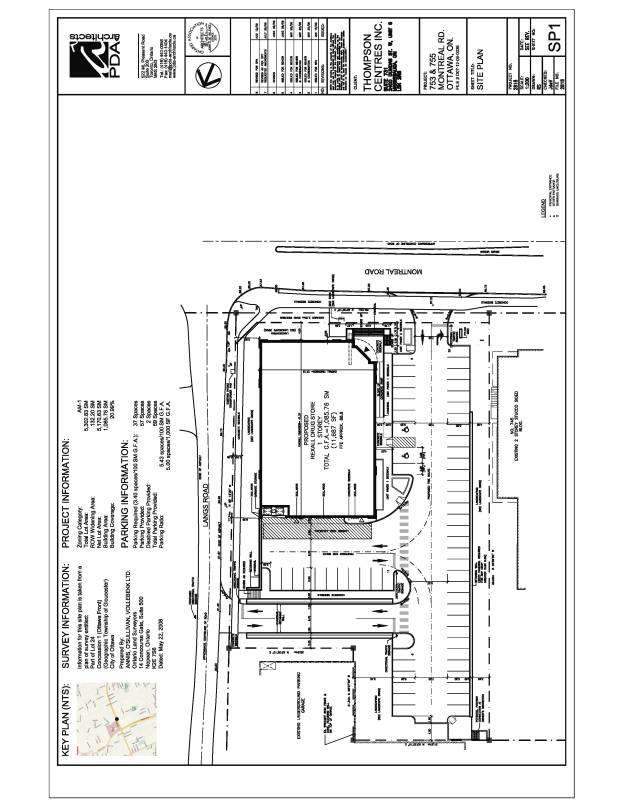
1.
"Site
Plan, 753 and 755 Montréal Road, Sheet No. SP1" prepared by
PDA Architects, dated as revised to August 12, 2009 and received by the
City on August 13, 2009;
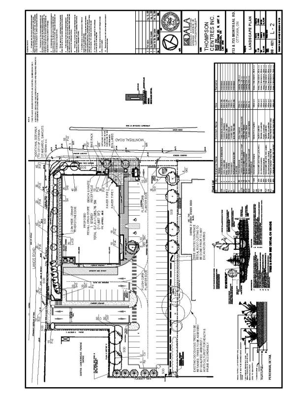
2.
"Landscape Plan, 753 and 755 Montréal Road,
drawing number L-2", prepared by Douglas Associates, Landscape Architects
Ltd., dated November 4, 2008, revised to August 10, 2009 and dated as received
by the City on August 13, 2009; and
3.
"Existing Vegetation/Preservation Plan, 753 and 755 Montréal
Road, drawing number L-1", prepared by Douglas Associates, Landscape
Architects Ltd., dated November 4, 2008, revised to August 10, 2009 and
dated as received by the City on August 13, 2009.
subject to the conditions contained in Document 5.
RECOMMANDATIONS DU RAPPORT
Que le Comité de l'urbanisme et de
l'environnement appuie l'approbation de la demande de réglementation du plan
d'implantation visant le 753, chemin Montréal, qui est illustrée par les plans
suivants :
1.
« Plan
d'implantation, 753 et 755, chemin Montréal, feuille no SP1 »,
produit par PDA Architects et daté tel que révisé le 12 août 2009 et reçu à la
Ville le 13 août 2009;
2.
« Plan d'aménagement paysager, 753 et 755,
chemin Montréal, dessin numéro L-2 », produit par Douglas Associates,
Landscape Architects Ltd, daté du 4 novombre 2008, révisé le 10 août
2009 et reçu à la Ville le 13 août 2009; et
3.
« Plan de préservation de la végétation,
753 et 755, chemin Montréal, dessin numéro L-1 », produit par Douglas
Associates, Landscape Architects Ltd., daté du 4 novembre 2008, révisé le
10 août 2009 et reçu à la Ville le 13 août 2009.
sous réserve
des conditions énoncées au document 5.
BACKGROUND
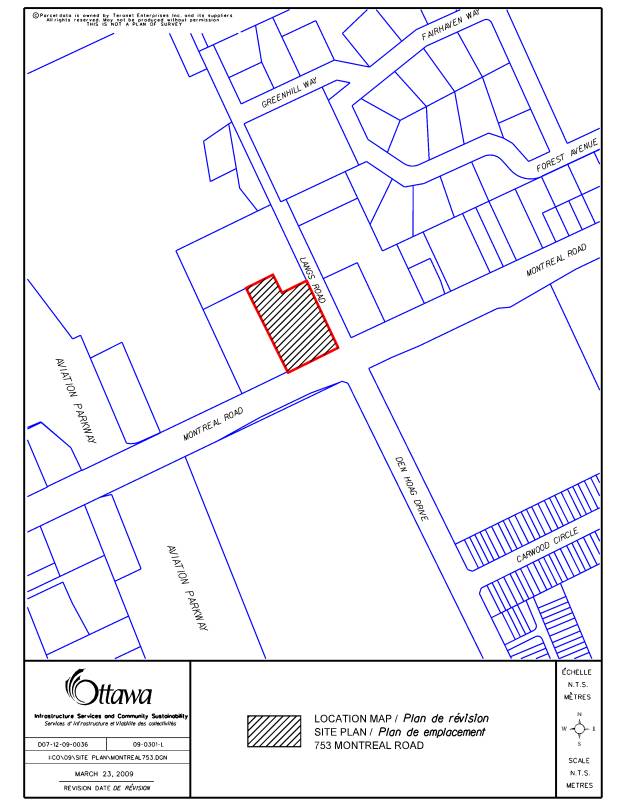
The subject property is located at 753 and 755 Montréal Road, on the northwest corner of the intersection of Montréal Road and Lang’s Road, east of the Aviation Parkway and the access road for the Montfort Hospital.
Site Context
The subject property is irregularly shaped with an area of approximately 0.5 hectares, 59 meters of frontage along Montréal Road and a depth of approximately 99 meters, 78 meters of which has frontage along Lang’s Road. There is an increasingly steep slope along the property’s easterly edge moving south to north, resulting in a significant drop from Lang’s Road to much of the site. Montréal Road at this location is four lanes plus a turning lane. Lang's Road is built to a rural road cross section, narrows from south to north and rises about 3.27 metres along the easterly side of the site.
A former restaurant and a motel currently occupy the front of the site, with parking in front of the motel and a large parking area to the rear. There is evidence of significant informal overflow parking from surrounding uses currently using the rear parking area. Neighbouring land uses include single dwellings residential to the east, an office building across Montréal Road to the south, a commercial building immediately west of the site, and a high-rise apartment building to the north. To the northeast is the Fairhaven/Greenhill low-density residential community with large, extensively vegetated lots, and which is serviced by wells and septic tanks. There are two dwellings on the east side of Lang's Road opposite the south end of the site. The western and northern neighbouring uses border on the Montfort Hospital property.
Proposed Development
The purpose of the subject application is to permit the development of a new one-storey retail building for use as a pharmacy. The existing buildings would be demolished. The proposed freestanding building would have an approximate area of 1086.0 square metres and would be situated in the southeast corner of the property, with the front building facade oriented to Montréal Road. The store’s entrance would be located in the southwestern corner of the building and would open onto a raised area extending towards Montréal Road. The entrance would be accessed via stairs facing south and west and a ramp along the western wall of the building.
The parking lot would be accessed by vehicular entrances in the southwest from Montréal Road and northeast from Lang's Road, and would consist of 59 parking spaces, including two reserved for disabled parking. Sidewalks and crosswalks would link the parking to the store entrance. A new walkway would be provided along the easterly edge of the property adjacent to Lang's Road, with a connecting sidewalk and stairs adjacent to the Lang's Road entrance. A loading facility and garbage enclosure would be located along the rear side of the building and be separated from the parking lot by a concrete retaining wall. A combination of existing and new vegetation would be provided around the site.
DISCUSSION
Official Plan Conformity
The Official Plan designates the property as Arterial Main Street, which applies to both sides of Montréal Road east and west of the site. The Strategic Directions objective for Mainstreet areas is that they should develop as a mix of uses including employment and shopping. Mainstreets are to be one of the primary locations for intensification. The policies of Section 3.6.3 pertaining to the Mainstreet designation indicate that Arterial Mainstreets are intended to evolve as more pedestrian friendly and transit oriented areas. The recommended development proposal brings new retail use up to the edge of Montréal Road in keeping with the policies for Arterial Mainstreets.
Compatibility and Design
The policies for compatibility of Section 2.5.1 set out Design Objectives and Principles pertaining to compatibility. The proposed development is consistent with the intent of many aspects of the Design Objectives and Principles as discussed below, based on summaries of applicable elements of the objectives:
· Enhance the sense of community by creating places with their own identity: the development proposal will help create an architectural presence along the edge of Montréal Road, which is currently occupied by a small restaurant and an open parking lot serving an old motel. The proposal will help to continue the evolving existing pattern of active commercial development facing the north side of the street.
· Defining quality public spaces through development: the addition of the proposed new commercial development will help define and potentially enliven the streetscape with the addition of a new active main entrance to a retail facility, sitting areas, bicycle parking and the enhancement of a more formal streetscape design. The new building will help screen the parking areas from public view at the important intersection of Montréal Road and Lang's Road; and the pedestrian environment along the street will be served by a near-grade entrance and windows, and landscaping.
· Creating safe, accessible places, which are easy to get to: the site is highly visible, with frequent passers–by. Site access to the related development proposal will be clear and directly from an arterial roadway or via Lang's Road following significant improvements to the Lang's Road corridor. This will protect and improve the existing pedestrian route along Montréal Road. An on-site walkway adjacent to Lang's Road will significantly enhance the safety and comfort of pedestrians using this corridor. The development will increase the potential to provide the safety and security benefits of longer periods of passive surveillance provided by increased periods of regular site use; and will help create a complementary activity pattern along a transit route.
· Respecting the character of the existing area: the proposed new retail use will complement and enhance the mainstreet environment and the site development will be sensitive to the character of adjacent neighbourhood. The proposed built form will be complimentary to the massing and style of nearby lower profile commercial buildings, while the building placement and massing will embrace the unique characteristics of the raised landforms of the area. New plantings will help re-establish a more sustainable landscape along Lang’s Road in keeping with the landscaped character of the area.
· Giving consideration to diversity to achieve more compact urban form over time: the site plan concept for the proposed development maintains the possibility of promoting an even more compact urban form over time, making more efficient use of the land, while helping to give a build edge and diversity to the character of the north side of this segment of Montréal Road as a Mainstreet. The development proposal will help foster an appropriate mix of commercial uses near a major hospital.
· Promoting environmentally sustainability in development: the related development will help reduce resource consumption by promoting intensification in the form of employment and a neighbourhood serving commercial use, a pharmacy, inside the Greenbelt along a transit route. The related development proposal provides for retention of significant existing trees and appropriate addition of new trees and other increases in landscape areas along the street and on the site, without causing undue conflict with existing utility infrastructure.
Section 4.11 Compatibility, provides further compatibility policy for the review of development applications and indicates that properties along the edges of neighbourhoods or along major roads may be acceptable locations for more intense development. The subject site satisfies those locational criteria for more intense development. Other factors to be considered include traffic impact, vehicular access, parking, building height and mass, community patterns, loading areas, and supporting neighbourhood services.
· One site access will be directly from Montréal Road, an arterial roadway, using a new entrance with the benefit of increasing the separation from the Lang's Road intersection as compared to the existing entrance, and thus improving this access safety. The second access is to be from Lang's Road, which will facilitate safe movement to and from the site for vehicles arriving or departing in an easterly direction using the signalized intersection of Montréal Road and Lang's Road. The proposed Lang's Road access has been positioned close to the top of the rise in Lang's Road to help maximize visibility of turning movements into the site for drivers accessing the development, and for those coming from either side of the rise. The addition of the adjacent on-site walkway in this location and clearing of unmanaged tree and shrub growth, which currently impairs visibility, will significantly improve the environment available to pedestrians using the Lang's Road corridor. These improvements will also facilitate improved winter maintenance and help address winter access concerns.
· Loading and service areas to serve the related development will be screened from the street and nearby residential areas by proposed and existing trees, and the mass of the building.
Access
Section 4.3, Walkling Cycling, Transit, Roads and Parking Lots of the Official Plan sets out policies germane to the evaluation of significant access issues associated with the proposed site plan. The essence of the relative policies discussed here is consistent with the recent Official Plan amendments approved by City Council. This section indicates that the City, “when reviewing development applications, will assess the adequacy of the transportation network to meet the needs of the proposed development. Individual building sites, subdivisions and plans for large areas must be easy to get to and travel through on foot, by bicycle and transit, and by automobile. Supporting walking, cycling and transit means more than the simple provision of sidewalks and pathways. A logical network must be created, connecting origins and destinations along direct and well-marked routes. Landscaping, the positioning of buildings, and other features of adjacent development can be further organized to support pedestrians and cyclists.”
Policy 5 of Section 4.3 indicates that a transportation study is required, “where the City determines that the development may have an impact on the transportation network in the surrounding area”, that the “scope of the study will vary depending on the nature of the development”, and that “under most circumstances, a study will not be required for minor infill development in areas where the road network is fully established.”
Although this development is considered minor infill, a transportation study was submitted with the application and was subsequently augmented with specific geometric engineering evaluation of the safety and visibility factors related to the proposed access from Lang’s Road, and with a further analysis pertaining specifically to winter conditions. The studies have been evaluated by staff, resulting in a determination that the planned Lang’s Road access can function effectively and safely given the relatively low volumes of traffic involved, coupled with the improvements proposed by the applicant along the adjacent segment of the Lang’s Road corridor. The option of a Lang’s Road access that functions as a one-way in only, has also been determined to be acceptable, as it would allow drivers to arrive from the west along Montréal Road without enticing a U-turn at the intersection, while still retaining the right-in and right-out movement available on Montréal Road.
The proposal involves improved sight lines through the removal of under-growth and the increased set back of the building, plus the addition of an on-site, all-season walkway the length of the Lang’s road frontage, which currently has no public or private pedestrian facilities. A new on-site sidewalk will also link the northeast corner of the property to the proposed building. The pedestrian environment will be improved along Montréal Road with an alternative walking route, an increased setback from the immediate edge of the arterial roadway and the addition of bicycle facilities.
Services
The property is adequately served by water, and sanitary and storm sewer facilities to support the extent of the proposed redevelopment.
Zoning By-law Requirements
The subject property is designated “Arterial Mainstreet (AM1)” in the Zoning By-law. The intent of the AM zone is to accommodate a broad range of uses including retail, service commercial, offices, residential and institutional uses in mixed-use buildings or side by side in separate buildings in areas designated Arterial Mainstreet in the Official Plan; and to impose development standards that will promote intensification while ensuring that they are compatible with the surrounding uses. The AM1 zone permits retail and other commercial uses such as the proposed pharmacy with an added limit on the extent of non-residential uses. Based on the information provided to date the proposal satisfies all the requirements of the Zoning By-law provisions for parking, loading, yards and height.
Urban Design Guidelines
The design of the proposed development is considered to be in keeping with the Council approved Urban Design Guidelines for Development along Arterial Mainstreets pertaining to streetscape improvements, enhancing the pedestrian and cycling environment, built form, parking and circulation, landscape and environment and building design.
Private Approach By-law
The City's Private Approach By-law establishes basic requirements for the design, size, location and number of access driveways providing vehicular access between a City street and a private property. These requirements are based on basic safety and functional considerations. The access to the subject site must satisfy the requirements of the Private Approach By-law, and the recommended plans and conditions are considered to be in keeping with that requirement.
Summary
The proposed site plan control application has been reviewed in relation to the applicable policies of the Official Plan, the Zoning By-law (based on the information available to date) and the Urban Design Guidelines for Development along Arterial Mainstreets and it is the Department’s opinion that the application merits approval.
ENVIRONMENTAL IMPLICATIONS
The site development will involve the loss of some existing vegetation along Lang’s Road in order to improve vehicular and pedestrian safety in the Lang’s Road corridor, the retention of large trees to the rear of the site and the addition of new trees and shrubs. The standard need to test excavated soil for potential contamination and the need to test for designated substances with the demolition of the existing buildings on the site are addressed by Special Conditions 9 and 10 respectively in Document 5.
CONSULTATION
Notice of this applicaton was carried out in accordance with the City's Public Notification and Consultation Policy. The Ward Councillor is aware of this application and the staff recommendation.
The primary issues can be summarized as follows:
- Concerns regarding vehicular and pedestrian access and safety along Lang’s Road, especially in winter;
- Design along Montréal Road;
- Impacts on neighbourhood character and environment, wells, septic systems, lighting, garbage, noise.
Detailed responses to the notification/circulation are provided in Document 6.
LEGAL/RISK MANAGEMENT IMPLICATIONS
This site plan has been referred to the
Ontario Municipal Board and a hearing has been set down for 8 September
2009. As outlined above, Planning staff
can support either the entrance off Lang's Road being for access and egress or
access only. At this time, Legal
Services does not have any professional transportation opinion evidence that
would support no access being permitted off Lang's Road at all.
FINANCIAL IMPLICATIONS
APPLICATION PROCESS TIMELINE STATUS
The application was not processed by the "On Time Decision Date" established for the processing of Site Plan Control applications due to the need to thoroughly assess issues and solutions to concerns about access to Lang's Road.
SUPPORTING DOCUMENTATION
Document 4 Vegetation
Preservation Plan
Document 5 Conditions
of Site Plan Control Approval
Document 6 Consultation
Details
DISPOSITION
Legal Services to prepare the Site Plan Control agreement.
Planning
and Growth Management to notify the owner:, R. Gene Encarnacao
Encarnacao Holdings Ltd., 753 Montréal Road, Ottawa, ON, K1K 0T1; applicant: L. Meandro, Thompson Centres Inc., Unit 6. 2400 Dundas Street West, Mississauga, ON, L5K 2R8; Planner: Brian Casagrande, FoTenn Consultants Inc., 223 McLeod Street, Ottawa, ON, K2P 0Z8; OttawaScene.com, 174 Colonnade Road, Unit #33, Ottawa, ON K2E 7J5, and all interested parties of Planning and Environment Committee’s decision.
LOCATION MAP DOCUMENT
1
SITE PLAN DOCUMENT
2
LANDSCAPE PLAN DOCUMENT
3
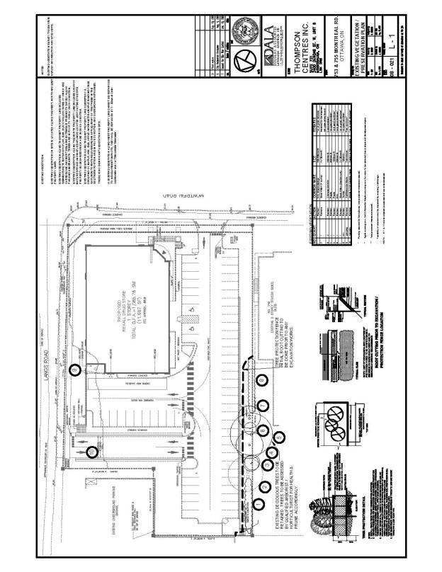
VEGETATION PRESERVATION PLAN DOCUMENT
4
CONDITIONS OF SITE PLAN CONTROL APPROVAL DOCUMENT 5
STANDARD CONDITIONS
1.
Permits
The Owner(s) shall obtain such permits as may be required
from Municipal or Provincial authorities and shall file copies thereof with the
General Manager, Planning and Growth Management Department.
2. Extend Walkways
The Owner(s) agrees to extend internal walkways beyond the
limits of the subject lands to connect to existing or proposed public
sidewalks, at the sole expense of the Owner, to the satisfaction of the General
Manager, Planning and Growth Management Department.
3. Barrier Curbs
The Owner(s) agrees that the parking areas (and entrances)
shall have barrier curbs and shall be constructed in accordance with a design
approved by the General Manager, Planning and Growth Management Department.
4. Water
Supply for Fire Fighting
The Owner(s) shall provide adequate water supply for fire fighting for every building. Water supplies may be public water works system, automatic fire pumps, and pressure tanks or gravity tanks.
5. Reinstatement of City
Property
The Owner(s) shall reinstate at its expense, to the satisfaction of the General Manager of Planning and Growth Management Department of the City, including, but not limited to, sidewalks and curbs, boulevards, that are damaged as a result of the subject development.
6. Construction Fencing
The Owner(s) shall be required to install construction fencing at its expense, in such a location as may be determined by the General Manger of Planning and Growth Management Department.
- Maintenance and Liability Agreement
The Owner(s) shall be required to enter into a maintenance and liability agreement for all plantings, except for trees, decorative paving, street furnishings and other landscaping material placed in the City’s right-of-way, and the Owner(s) shall assume all maintenance and replacement responsibilities in perpetuity.
8. Completion of Works
No building will be occupied on the lands, nor will the Owner(s) convey title to any building until all requirements with respect to completion of the Works as identified in this Agreement have been carried out and received Approval by the General Manager, Planning and Growth Management Department, including the installation of municipal numbering provided in a permanent location visible during both day and night and the installation of any street name sign on relevant streets. Notwithstanding the non-completion of the foregoing Works, conveyance and/or occupancy of a lot or structure may otherwise be permitted, if in the sole opinion of the General Manager, Planning and Growth Management Department, the aforesaid Works are proceeding satisfactorily toward completion. The Owner shall obtain the consent of the General Manager, Planning and Growth Management Department for such conveyance and/or occupancy in writing.
9. Site Lighting Certificate
Prior to the registration of the site plan agreement, the applicant shall provide a certificate, from an acceptable professional engineer, that the site lighting has been designed to meet the following criteria:
(a) It must be designed using only fixtures that meet the criteria for Full Cut-Off (Sharp cut-off) Classification, as recognized by the Illuminating Engineering Society of North America (IESNA or IES), and;
(b) It must result in minimal light spillage onto adjacent properties. As a guideline, 0.5 fc is normally the maximum allowable spillage.
Upon completion of the works, the applicant must provide certification satisfactory to the City that the site lighting has been constructed in accordance with the applicant’s design prior to the City releasing any associated securities.
10. Waste Collection
a.
Waste
collection and recycling collection will not be provided by the City. The applicant should make appropriate
arrangements with a private contractor for waste and recycling collection.
b.
The owner should consult a private
contractor regarding any access requirements for waste and/or recycling
collection.
SPECIAL
CONDITIONS
1.
Final
Drawings Approval
That the finalization of all required drawings, including, but not limited to the Site Plan, Landscape Plan, Site Servicing Plan and the Grading Plan, and of all related required conditions of approval, shall be to the satisfaction and approval of the General Manager, Planning and Growth Management Department.
- Drawing Revisions
The Owner shall revise the proposed plans shown in Documents 2, 3 and 4 to the satisfaction and approval of the General Manager, Planning and Growth Management Department, as follows:
a. To include garbage storage and pickup locations clear of all proposed walkways and appropriately screened.
b. To include screening of all parking and servicing areas from views from Montréal Road, Lang’s Road and from the adjacent property to the north,
c. To show the relationship of all buried services and landscaping elements
d. To show any proposed on-site vehicle control signs, including no-left turn signs for existing from the Lang’s Road private approach,
e. Such revisions as may be required to rectify discrepancies amongst the proposed Site Plan, the proposed Landscape Plan, and the required engineering drawings as per Special Condition 1 above
f. To reflect changes required to address the final versions of the building façade designs.
3. Lang’s Road Walkway
a. The Owner(s) shall grant to the City, in perpetuity and at no cost to the City, within three months of completion of the
proposed walkway along the Lang’s Road frontage of the subject property, a
pedestrian surface easement having a width of not less than 3.0 metres
sufficient to ensure, to the satisfaction of the City and in accordance with
the approved Site Plan and the approved Landscape Plan, provision of a
continuous, uninterrupted and unimpeded, except where it crosses the on-site
private approach, concrete pedestrian walkway having a minimum width of 1.5
metres, between the most north-easterly corner of the property and Montréal
Road. The required reference plan for
the easement(s) must be tied to the Horizontal Control Network in accordance
with the municipal requirements and guidelines for referencing legal surveys,
and must be submitted to the City of Ottawa Surveyor for review prior to its
deposit in the Registry Office. The
Easement Agreement, to be
registered upon the title of the property, shall establish that the Owner is responsible
for all maintenance of the required walkway throughout the year, including all
repair and normal periodic reconstruction over time, to City standards. The Easement Agreement shall also require the Owner(s), in perpetuity, to save
harmless and indemnify the City for all damages and costs of all works, activities, and requirements associated with the
provision, and construction of the walkway, and maintenance, of that portion of the
walkway within the easement, save and except those arising from gross
negligence on the part of the City.
b. The walkway within the easement, as per condition a. above, shall be built to City standards, as a contiguous walkway and in accordance with the approved Site and Landscape Plan.
4. Road Widening
The Owner(s) shall convey, at no cost to the City, within six months of signing the required agreement, a road widening across the complete Montréal Road frontage measuring 18.75 meters from the existing centreline of pavement. The exact widening must be determined by legal survey. The owner shall provide a Reference Plan for registration, indicating the widening. Such reference plan must be tied to the Horizontal Control Network in accordance with the municipal requirements and guidelines for referencing legal surveys and will be submitted to the City of Ottawa Surveyor for review prior to its deposit in the Registry Office.
- Corner Sight Triangle
The Owner(s) shall convey, at no cost to the City, within six months of signing the required agreement, a 5m x 5m corner sight triangle. The owner shall provide a Reference Plan for registration. Such reference plan must be tied to the Horizontal Control Network in accordance with the municipal requirements and guidelines for referencing legal surveys and will be submitted to the City of Ottawa Surveyor for review prior to its deposit in the Registry Office.
- Permanent Features
No permanent features will be permitted above and below-grade within the widened right-of-way or corner triangle, including commercial signage.
- Traffic
Impact/Overview Study
The Owner(s) has undertaken a Transportation Impact Study for this site. The purpose
of the study
is to estimate the anticipated traffic volumes associated with the development,
investigate the expected impact on the needed road system and determine the
road modifications. This study should include impacts this site will have on
pedestrian, cycling and transit requirements associated with this site, and
other measures required to accommodate the development. The Owner(s) agree to implement the recommendations
of this study at its cost to the satisfaction of the General Manager, Planning
and Growth Management Department.
8. Public Roadway Modifications
The Owner(s) are responsible for all costs associated with the public
roadway modifications required to accommodate this development, including, but
not limited to the provision of an intersection warning sign(s) for the private
approach along Lang’s Road and removal of the Montréal Road depressed median
fronting the property, to the satisfaction of the
General Manager, Planning and Growth Management Department.
9. Soil Management
The Owner(s) agrees to undertake
testing for contamination of any soils, fill and /or debris to be removed, and
that if any of these materials are found to be contaminated, they must be
disposed, treated or recycled at a waste disposal site or landfill licensed for
that purpose by the Ministry of Environment (MOE).
10. Designated
Substances Survey
Prior to any on-site demolition work, the Owner(s) agrees to undertake and implement the recommendations of Designated Substances Survey, in accordance with Best Management Practices, including but not limited to:
a. Asbestos on Construction Projects. (O.Reg 278/05)
b. Lead on Construction Projects (ISBN 0-7794-6774-4) Made Under the Occupational Health and Safety Act.
c. Registration Guidance Manual
for Generators of Liquid Industrial and Hazardous Waste. (O.Reg 347)
d. Proposed Regulation Respecting
Lead on Construction Projects Made Under the Occupational Health and Safety
Act.
e. Waste Management - PCBs. (O.Reg 362)
11. Private
Wells or Sanitary Systems
The Owner(s) agrees that should any private
wells or sanitary systems be found on the property, they shall be
decommissioned as required by the applicable requirements and standards of the
Ministry of Environment (MOE).
12. Tree Protection
The Owner(s) shall undertake the following tree protection measures on the subject site for all trees shown to be retained, as per the approved plans on the subject property and nearby on adjacent property(s) to the satisfaction of the General Manager, Planning and Growth Management Department:
a. To ensure minimal damage to any roots or branches from
existing trees located on adjacent properties, any required pruning or removal
of roots or branches shall be undertaken by a qualified arbourist or similar
expert, using current best practices.
b. Prior to any site
development or demolition, protective metal or wooden fencing having a minimum
height of 1.2 metres shall be installed for all trees shown to be retained on
the approved plans at a distance not less than 2.0 metres from the base of the
subject trees. The required fencing
shall remain in place until the completion of all construction and site works.
c. All trees to be
retained shall be pruned by a qualified arbourist or similar expert, using
current best practices.
d. There shall be no
storage of materials or equipment within the drip-line of all trees to be
retained.
e.
13. Roof-top Noise Equipment Location
The applicant agrees to locate all roof-top HVAC equipment as far away as practicable from the nearby residential development.
14. Snow Removed
The Owner(s) agrees to remove snow from the area within 7.5 metres of the Lang’s Road private approach such that that minimum visibility standards in the area of the intersection are maintained at all times in accordance with current best practices and/or the Transportation Association of Canada Manual (TAC Manual) to the satisfaction of the General Manager, Planning and Growth Management Department.
15. Cash-in-Lieu of Parkland
The Owner(s)
shall pay cash-in-lieu of parkland in accordance with the Parkland Dedication
By-law of the City of Ottawa, as well as the fee for appraisal services, such
amounts to be paid at the time of execution of the Site Plan Agreement.
CONSULTATION DETAILS DOCUMENT
6
NOTIFICATION AND CONSULTATION PROCESS
Notification and public consultation was undertaken in accordance with the Public Notification and Public Consultation Policy approved by City Council for Site Plan amendments. Two public meetings were also held in the community.
PUBLIC COMMENTS
Public consultation, as per City Council policy, consisted of writen notification to community groups from the area that are registered with the City for notification, and the posting of two on-site notification signs on the property.
Councillor Jacques Legendre organized two public meetings in the community to discuss the proposal and revisions to the proposal.
SUMMARY OF PUBLIC INPUT
The issues raised by the public are listed below with the staff response in each case:
1. The ground water impacts on nearby private wells; is there a Ground Water Study and Contingency Plan. Regular tests of the water supply should be done during the entire construction phase. It takes about 2-3 weeks after construction vibrations from a Ram-hoe or ground compactor to affect well water quality in the area, and about 2-3 months to clear once the vibrations stop. It is not evident from the studies done by TROW if abandoned septic tanks of wells existed previously at this site, and these can become a source of future groundwater contamination.
2. The construction vibration impacts on nearby septic tank systems and foundations. Is there a Vibration Monitoring and Contingency Plan (Vibrations can cause significant damage to older wells and septic tanks nearby. For example, we believe a cast iron pipe separating the 2 chambers of our septic tank broke due to compactor vibration during the expansion project of the Montfort Hospital. There were no inspections done prior to construction.)
Response: The engineering consultants for the project have indicated that conventional construction will be carried out at this site and, therefore, no significant vibrations are anticipated; and since they are not driving piles, blasting or hoe ramming at this site, no vibration monitoring or contingency plans are expected. Furthermore, the zone of influence of these vibrations is minor and should not extend beyond the boundaries of the subject site.
3. The garbage collection and the resulting litter impacts, especially along Lang’s Road
Response: Garbage will be stored in an enclosed
structure located at the rear of the building. As well the site will be subject to the City's
property standards by-law.
4. The fire truck access/egress,
Response: No on-site designated fire-route is required given the building position and relationship to a nearby hydrant.
5. The snow clearing storage impacts on landscaping,
Response: Snow cleared from
the parking lot and internal pathways will be piled on parking spaces located
at the rear of the site. Therefore, the landscaping situated along the
perimeter of the site will not be affected.
The proposal offers more parking than the zoning by-law requires and
loss of parking in this case should not be an issue.
6. The building shadow impacts,
Response: The City does not ask for shadow casting
studies for single storey buildings, since all impacts would be considered
negligible and primarily impacting the applicant's own property.
7. The street width and intersection impacts during construction,
Response: The City's engineers have confirmed that
road and intersection disruption
caused by connecting the proposed development to existing municipal infrastructure located underneath Montréal Road will last less than one week. The disruption will be in the form of lane closures. This would occur with almost any redevelopment of the property.
8. The storm water impacts,
Response:
The site has been specifically designed to ensure that post-development
stormwater runoff does not exceed pre-development levels. There
are no anticipated water or sewer servicing issues for the proposed
development. City engineering staff will review and must be satisfied with
all drainage, sewers and water services reports and drawings before they
are approved by the City.
9. What are the public security and surveillance measures for theft and vandalism,
Response: The applicant has indicated that the proposed Rexall pharmacy will have an internal security system as well as exterior security lighting to deter vandalism and public safety risk. The applicant has indicated that any vandalism that occurs on the exterior of the building will be repaired by Rexall in a timely manner and that they have a vested interest in providing a pleasant environment for their customers.
10. The pedestrian traffic forecasts and sidewalk boulevard locations,
Response: The proposed
plan includes a separate walkway along the east side of the property parallel
to Lang’s Rd, and that this route will allow for public use leading to Montréal
Road.
11. The emergency generator and fuel storage impacts if included in this plan,
Response: The applicant has indicated that the proposed development
will use a battery-powered generator.
12. What is the plan for graffiti mitigation on any walls of the building, especially on the east side by Lang's Road,
Response:
This is not a Site Plan Control issue, but clean-up of graffiti by
property
owners is obligated by the City's
Graffiti Management By-law (2008-01).
13. The landscaping and monthly cleanup maintenance between Lang's Road and the Drug store,
Response: The applicant has indicated that they care
about the appearance of their stores and that the proposed landscaping will be
regularly maintained to a high standard. The City will require a detailed
landscape plan for the entire site and requires 50% (on private
property) to 100% (on City property) financial security for the
landscaping until such time as it has been properly installed and inspected.
14. The preservation of existing mature trees,
Response: As illustrated in the Landscape
Plan and the Existing Vegetation/Preservation Plan, the existing trees along
the western edge of the subject property and in the
southeast corner of the neighbouring property to the north are
to be protected and saved as much as possible.
15. The street lighting and security spotlight impacts on neighbours; is there an Illumination Study and Contingency Plan. There is no indication of the location or direction of illuminated signs for the Drug Store.
Response: There will be no changes to the existing street lighting and there is no proposal to use security spotlights. The City requires that the applicant retain a lighting expert to assess the proposed lighting. The consultant must sign a certificate stating that there will be no adverse impacts to surrounding properties as per Standard Condition 9 in Document 5. Signs are covered under the City’s Signs By-law and require a separate permit.
16. The HVAC noise level impacts from rooftop systems, especially for those living in the apartment at 550 Lang's Road and also the homes along Lang's Road,
Response:
Given the proposed pharmacy use, the anticipated HVAC noise impacts are
negligible. The applicant is required to
demonstrate that the specifications of the
proposed equipment are within Ministry of
the Environment noise guidelines. The
applicant has indicated that should noise become an issue, they are willing to
install appropriate sound barriers surrounding the rooftop equipment. The
proposed Rexall will not be releasing any substances that have the ability to
impact air quality. As per Special Condition 13 in Document 5, the
applicant is required to locate any roof-top HVAC equipment as far from the
surrounding residential areas as practicable.
17. How will the applicant address the increased traffic congestion patterns, intersection impacts, and noise, especially due to people using the parking lot to avoid paying for parking at the Montfort Hospital; and given the increased traffic at the hospital and the future developments on Den Haag.
Response: The Transportation Impact Study (TIS) which assesses the impacts
of
the proposed development on the existing
roads and intersections in the immediate area makes the following findings and
recommendations based on traffic volumes anticipated at site build-out and 5
years into the future (2014):
- A total of 37 trips are expected in the
weekday peak AM hour (22
entering, 15 exiting) and a total of 96
trips are expected in the weekday
peak PM hour (48 entering, 48 exiting).
- Southbound right-out site exit movement
onto Montréal Road would
function at a Level of Service (LoS)
"C" during 2009 and 2014 peak AM
hours and a LoS "B" at the 2009
and 2014 peak PM hour. LoS "B"
means "short traffic delays" and
LoS "C" means "average traffic
delays". There would be no
requirement for modifications to Montréal
Road.
The
Lang's Road entrance would function at a LoS "A" during the 2009
and
2014 peak AM and PM hours. LoS "A" means "little or no
delay".
There
would be no requirement for intersection modifications due to
the
Rexall Pharmacy development.
The
Montréal Road/Lang's Road intersection would operate at LoS "A"
during
the 2009 peak AM and PM hours and a LoS "B" during the 2014
peak
AM and PM hours. There would be no requirement for
intersection
modifications due to the Rexall Pharmacy development.
City staff have reviewed the
Traffic Impact Study submitted with the application and agree with the basic
analysis and conclusions. However in response to concerns expressed by
the community regarding vehicular and pedestrian safety along Lang’s Road and
regarding potential increases to traffic cutting through the neighbourhood, the
original proposal has been modified to include design revisions and signage for
the Lang’s Road access to discourage access to and from the north
and the elimination of large truck access from Lang’s Road.
18. The traffic noise and traffic calming measures,
Response: The projected
traffic volume will not be substantial enough to warrant noise barriers or
traffic calming measures.
19. The absence of any environmental design considerations such as solar collectors or a green roof concept.
Response:
The new building will use modern building systems, which tend to
exhibit
higher than average levels of efficiency. The City will also
be requiring the use of current, more environmentally sensitive, engineering
standards for stormwater systems, the proposal includes planting of trees
and shrubs and retention of existing vegetation as much as possible.
20. The Air Quality/Noise Study and Contingency Plans. (Consider where heavy garbage trucks will pick up garbage. There is a lot of noise, bad smells and litter associated with this operation. Animals getting into dumpsters can spread garbage throughout the community that needs to be picked up weekly. Squealing tire noise can also result from tight turns in parking lots due to any through traffic. The noise and smells aren't obvious until construction is finished. Cars that drive over sewer covers can also make an intrusive noise as well, so their location needs to be identified. Consideration of speed bumps and their locations on the site plans are essential. Noise from HVAC units at night must be less than 45 dbA. Therefore noise level reading must be done before and after construction.)
Response: The use of the property and operation of the equipment on the property, where applicable, will be subject to Ministry of Environment Noise standards and the City’s Noise Property Standards By-laws.
21. There should be a Shadow Study; the height of the building must not interfere with access to sun and sky of adjacent residences.
Response: The applicant did not
produce a shadow study as it is not required by the City
Further, the proposed Rexall is one
storey in height and therefore will have
a similar, if not identical, shadow impact as the one-storey restaurant that
currently exists on the site.
22. On the date the City approves the final site plan, the plan must not be changed without the consent of the public. Any design changes to the final approved site plan will need to be approved by the City staff and thereafter controlled to safeguard the public's expectations of what is being built. Independent inspections and reports during construction to ensure conformity to the site plan is expected. Any major negative impact such as fuel spills must be reported immediately to the surrounding community and Contingency Plans put into effect.
Response: Any revisions to an approved Site Plan requiring an application will be governed by the City’s Site Plan Control By-law and the applicable City Council policy for public notification. Minor revisions to site plans involving very small modifications to buildings, minor changes to circulation systems or landscape changes may not require public notification.
23. The proposed building
should be turned 90 degrees to provide better orientation to Montréal Road and
a more pedestrian friendly street environment.
Response: The position of the building addresses the intersection and the
mass of the building acts as a retaining structure in response to the
topography along Lang’s Road. Proposed
sitting areas, a front entry court, and trees and shrubs will enhance the
Montréal Road pedestrian environment.
24. The proposed development will change the
nature of Lang’s Road.
Response: The rural road character of Lang’s Road will be maintained on the east side, but in keeping with its location in the urbanized part of the city and the Official Plan designation of Arterial Mainstreet, the west side will take on a more urban quality that will include new trees and shrubs. This change will help facilitate the improved functional safety of the south end of Lang’s Road for vehicular and pedestrian movement.
PUBLIC MEETING COMMENTS
Councillor Legendre organized two public meetings held in the community on May 5th, 2009 and June16th, 2009. The issues raised at the public meetings are listed below with the staff response in each case:
1. The roof top ventilation will cause disturbing noise; they must meet City noise standards.
Response: Given the proposed pharmacy use, the anticipated HVAC noise impacts are negligible. The applicant is required to demonstrate that the specifications of the proposed equipment are within Ministry of the Environment noise guidelines. The applicant has indicated that should noise become an issue, they are willing to install appropriate sound barriers surrounding the rooftop equipment. The proposed Rexall will not be releasing any substances that have the ability to impact air quality. As per Special Condition 13 in Document 5, the applicant is required to locate any roof-top HVAC equipment as far from the surrounding residential areas as practicable
2. The Land’s Road access is a significant problem. It will lead to more cut-thru traffic. The main concern is that the combination of narrowness of the roadway, lack of a sidewalk, and rise and fall of a hill and bend in the road to the north make Lang’s Road a problem, especially in the winter when there is limited ploughing and sanding/salting by the City. In the winter the roadway often narrows down to one lane. There is a very steep driveway right across from the proposed access; the added congestion will make access difficult and dangerous. In the winter it is very dangerous for pedestrians. The proposed Lang’s Road access to the pharmacy will exacerbate all these problematic conditions. The old gated access to Lang’s Road has not been used in many years and is not justification for the proposed development to have access. Why not try to share access and parking with the adjacent development to the west which has access to the signalized intersection on Montréal Road serving the Montfort Hospital.
Response: The Transportation Impact Study (TIS) which assesses the impacts
of the proposed development on the existing roads and intersections in the
immediate area makes the following findings and recommendations based on
traffic volumes anticipated at site build-out and five years into the future
(2014):
- A total of 37 trips are expected in the
weekday peak AM hour (22
entering, 15 exiting) and a total of 96
trips are expected in the weekday
peak PM hour (48 entering, 48 exiting).
- Southbound right-out site exit movement
onto Montréal Road would
function at a Level of Service (LoS)
"C" during 2009 and 2014 peak AM
hours and a LoS "B" at the 2009
and 2014 peak PM hour. LoS "B"
means "short traffic delays" and
LoS "C" means "average traffic
delays". There would be no
requirement for modifications to Montréal
Road.
The Lang's Road entrance would function at
a LoS "A" during the 2009
and 2014 peak AM and PM hours. LoS
"A" means "little or no delay".
There would be no requirement for
intersection modifications due to
the Rexall Pharmacy development.
The Montréal Road/Lang's Road intersection
would operate at LoS "A"
during the 2009 peak AM and PM hours and a
LoS "B" during the 2014
peak AM and PM hours. There would be no
requirement for
intersection modifications due to the
Rexall Pharmacy development.
City staff have reviewed the Traffic
Impact Study submitted with the application and agree with the basic analysis
and conclusions. However, in response to concerns expressed by the
community regarding vehicular and pedestrian safety along Lang’s Road, and
regarding potential increases to traffic cutting through the neighbourhood, the
original proposal has been modified to include design revisions and signage for
the Lang’s Road access to discourage access to and from the north
and the elimination of large truck access from Lang’s Road.
City staff have also reviewed the winter maintenance standard in effect for Lang’s Road, and it has been determined that it will be upgraded from the current “Class 5 Residential roads and lanes” standard to the “Class 4 – Minor collector roads” standard and, thus should receive a significant improvement in the level of winter maintenance (ploughing, salting, sanding etc). Special Conditions 3, 8 and 14, of Document 5 also require that the applicant provide adequate snow removal by the Lang’s Road access to maximize winter visibility, to maintain the east side walkway safe for winter use, and to provide an intersection warning sign for the Lang’s road access. Furthermore the redesign of the west side of the Lang’s Road corridor and increased set back of he new building will provide greater opportunities for proper snow storage.
3. The pharmacy will have trouble with over-flow parking from the Montfort Hospital
Response: Control of who uses the proposed parking lot is not a site plan control issue, but the applicant is aware of the issue.
4. There will be garbage from the pharmacy along Lang’s Road.
Response: Garbage will be stored in an enclosed structure located at the rear of the building. As well the site will be subject to the City's property standards by-law.
5. There should be a shadow study and it should look at the impact on the icy road.
Response: Shadow studies are not required for one-storey buildings.
COUNCILLOR’S COMMENTS
Councillor Jacques Legendre’s concerns are cited below along with staff responses to the councillor’s comments:
“The redevelopment of this site has broad community support.
The site plan, as proposed, incorporates several factors which are positive and would commend it to the PEC. Examples include the pedestrian pathway along the eastern edge of the property (along Lang’s Road) and the outward ‘face’ which the store will present to the public domain (Montréal Road).”
Response: Staff agree with the specific comments above on some of the merits of the proposal.
“Although, as these comments are being
written, I have not seen the final drawings depicting the entrance from
Montréal Road, I believe that the proponents have changed what was initially
proposed (i.e. from a very wide entranceway with large radii of curvature
intended to accommodate articulated highway trucks bringing materials from far
afield) to a more pedestrian-friendly opening which would accommodate
straight-bodied delivery trucks as well as private vehicles. It is also my understanding that the final
lay-out of the parking lot is that which was suggested by staff. That lay-out was a more convenient and a
safer arrangement for both drivers and pedestrians in the lot. That lay-out also allowed for an eventual pedestrian
connection to the apartment building property immediately to the north. Such a connection would further enhance the
safety merits of the overall site.”
Response: The width of the proposed access from Montréal Road has been narrowed, and the internal layout of pedestrian and vehicular facilities has been revised and improved.
“This site plan is before the PEC today largely because the proponent has insisted that a second access/egress be provided to Lang’s Road. The stated reason is to accommodate clients arriving/leaving equally from both the easterly and westerly directions of the arterial roadway. In Ottawa there are many successful commercial sites along arterial mainstreets which have only one entrance. Indeed, a recently approved site plan, involving a competing drug chain, just a few blocks west on this same Montréal Road has precisely that feature! Moreover, many such sites are further limited to right-in right-out movements.”
Response: It is recognized that many properties along arterial and some collector roadways are limited to right-in and right-out access. However, that limitation is not necessary at this location given the access options afforded the corner lot. Many corner lots will have access from both frontages and are sometimes limited to access from the less busy roadway (the roadway analogous to Lang’s Road), in order to reduce turning movements on and off of the busier road or to provide less disruption of mainstreet pedestrian areas.
“Lang’s Road is one of the City’s most sub-standard roads – a ‘country path first laid down by meandering moose’ would be a more fitting description. At the egress point it is very narrow, without sidewalks and it is at the top of a hill (Note: the proposed leg from the REXALL site will be very steep).”
Response: Lang’s Road is narrow and built to a rural cross-section, having a paved width of approximately 5.2 metres at the point of the proposed access, which is considered to be functioning adequately for two-way traffic and the levels of traffic using Lang’s Road. The top-of-hill location maximizes the visibility to the point of the access from both directions of on-coming traffic and for drivers using the access to enter or leave the site, and the evaluation of the sight-lines in this location demonstrates that visibility at the access point satisfies the standards of the Transportation Association of Canada Manual. The proposed development includes the addition of a walkway along the Lang’s Road corridor, and as per Special Condition 3 of Document 5, the walkway is to be available for public access. The access roadway from Lang’s Road to the parking lot must satisfy the grading requirements of the City’s Private Approach By-law, and involves maximum slopes of 2.0 and 6.0 per cent, which are not considered unusual or problematic.
“I do not believe that a strong case exists for allowing the access along the very narrow Lang’s Road for the following reasons:
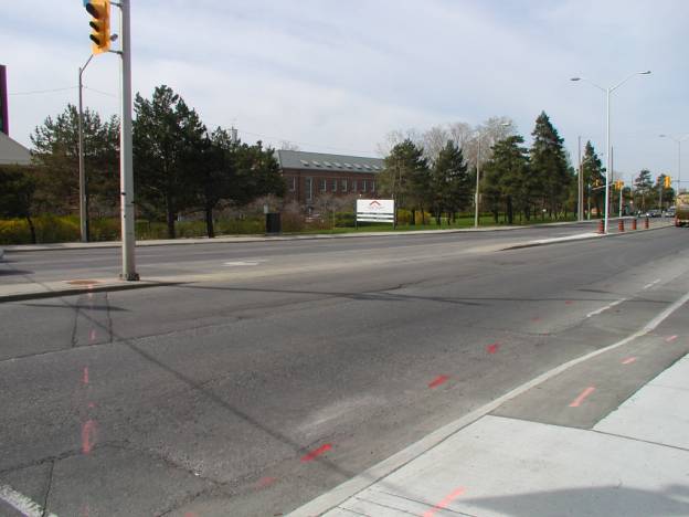
- The site has always provided for entering/exiting movements from both easterly & westerly directions on Montréal Road because of a depressed median (see attached photo #1). Therefore, the argument of necessity, if accepted, can be satisfied via the current configuration;”
Response: The new access does not align with the existing depressed median, which is very close to the signalized intersection, and a relocated depressed median would continue to be close to the intersection and within the left-turn lane leading to Lang’s Road, increasing the safety and functional concerns associated with a median break at this location.
“and,
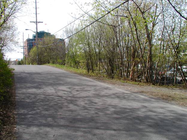
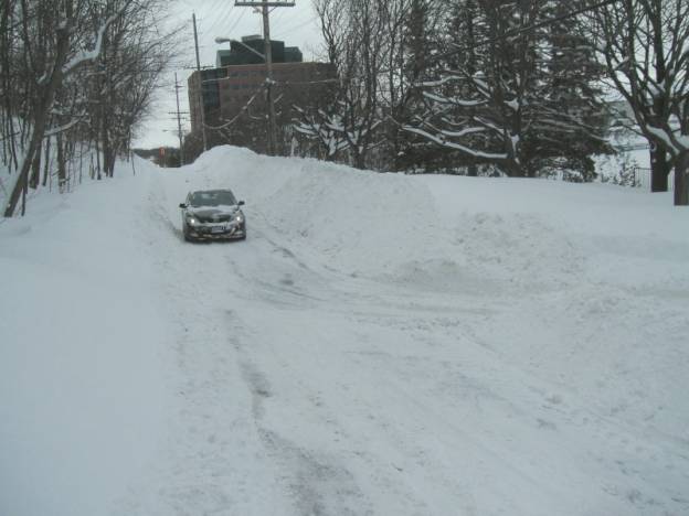
- “The secondary and superfluous access/egress along Lang’s Road has dubious safety aspects for both vehicles and pedestrians, most especially during the winter, due to the topography at the proposed entrance/exit. At the proposed connection point, all ‘roads’ go downhill, most sharply toward the site. Visibility would be problematical at the best of times; in winter it will be virtually non-existent. The attached summer photo (photo #2) shows the visibility on Lang’s Road in the south-bound direction as viewed from a point to the north of the hill on the roadway. Clearly, approaching movements from the opposite direction are not seen by either pedestrians or vehicles. The attached winter photo (photo #3), taken from a similar location (the summer photo was taken approximately at the location of the car in this photo) shows how much worse the situation will be in winter. Note that the site in question is so depressed with respect to Lang’s Road that the cars in the parking lot cannot be seen. Note also that the southerly (westerly?– staff) edge of Lang’s Road will be the preferred side for snow storage as the northern (easterly?– staff) edge rises quite steeply in places, particularly between Montréal Road and the hill-top. I draw attention to this so that the following consequences may be appreciated –
o vehicles exiting the site in winter will not have good visibility to either side (north or south) because of the snow bank (remember that northbound & southbound visibility is not good at any time of the year and it is now proposed to add a third direction with bad visibility from which vehicles may arrive at the hill crest!); and,
o vehicles exiting the site in winter will sometimes be required to approach the crest of the hill at speed, via a steeply graded ramp, if that ramp is not absolutely bare-surfaced; and,
o snow storage on the southerly edge of Lang’s Road will be in conflict with the proposed pedestrian pathway.”
Response: City staff have
reviewed the Traffic Impact Study submitted with the application and agree with
the basic analysis and conclusions in support of the application.
However, in response to concerns expressed by the community regarding potential
increases to traffic cutting through the neighbourhood, and regarding vehicular
and pedestrian safety along Lang’s Road, especially in the winter, the original
proposal has been modified to include design revisions and signage for the
Lang’s Road access to discourage access to the north towards the
neighbourhood, and to include the elimination of large truck access from
Lang’s Road.
City staff have also reviewed the winter maintenance standard in effect for Lang’s Road, and it has been determined that it will be upgraded from the current “Class 5 Residential roads and lanes” standard to the “Class 4 – Minor collector roads” standard and, thus should receive a significant improvement in the level of winter maintenance (ploughing, salting, sanding etc). Special Conditions 3, 8 and 14, of Document 5 also require that the applicant provide adequate snow removal by the Lang’s Road access to maximize winter visibility, to maintain the east side walkway safe for winter use, and to provide an intersection indication sign for the Lang’s Road access. Furthermore, the redesign of the west side of the Lang’s Road corridor and increased set back of he new building will provide greater opportunities for proper snow storage. The driveway ramp slope will meet the Private Approach By-law standards, including a maximum of 2.0 to 6.0% within the first 9.0 metres of the property line, and 2.0% from the property line to the travelled portion of the public roadway.
“I believe that PEC has good and sufficient reasons for denying the additional access/egress on Lang’s Road. Necessity of the access/egress has not been demonstrated. Furthermore, safety for both pedestrians and motorists will be compromised.
I ask the PEC to approve the site plan without the additional access/egress on Lang’s Road.
Jacques Legendre
Councillor
Rideau-Rockcliffe
Response: City planning, transportation engineering, and operations staff have reviewed the proposed development particularly with regard to the Lang’s Road access and have concluded that given the low levels of traffic, improvements to the site in the vicinity of the access point, and requirements and commitments to improved winter maintenance, that the proposed access will not be problematic and that the application should be supported.
COMMUNITY ORGANIZATION COMMENTS
The Fairhaven Co-operative Community Incorporated provided the following comments:
“753
Montréal Road redevelopment – new access using Lang’s Road
Dear Councillor:
You will recall that we spoke briefly at the conclusion of the 4 Apr
town hall meeting on this subject and I again with to thank you for sponsoring
and adjudicating this. The town hall
was timely as it preceded the Spring semi-annual meeting of the Fairhaven
Community and provided a good basis for discussion then. This letter follows up on both the views
expressed in my email to both of you on 23 Apr, and the questions and
discussion that ensued at the subsequent Fairhaven meeting.
More specifically, after considerable discussion at our community
meeting, it was decided that the Fairhaven Community wanted to express it’s
unease with, and unanimous rejection of, the proposal to allow traffic access
from the site on to Lang’s Road.
Beyond the universal feeling that the engineering of a T-junction at the crest of a three-way hill was ludicrous (and that is as mild as it was expressed), it is considered that Lang’s Road is too narrow to take the additional traffic that this access the new business through the back route leading to Codd’s Road. Over the past three years the increase in the number of commuters and hospital visitors using this short-cut has been considerable. You will recall that the Montfort Hospital used 528 Lang’s Road (the Levac house) as a business centre for two years, prior to tearing it down. During that period the preference for heavy delivery, sewage and garbage vehicles to use the route from Codd’s Road through Fairhaven and Green Hill for entrance and egress was an irritation to the community (and a cause of considerable damage to both Lang’s and Green Hill Roads). The community is convinced that if the 753 Montréal Road site is given a “back door”, then this pattern will be repeated with even higher volume and even larger, heavier vehicles. The community welcomes the redevelopment of 753 Montréal Road, however it feels strongly that traffic into and out of the site must continue its habitual and traditional pattern.
For my own part, I walked the ground again after these meetings, and make the following gratis observations:
a. I note that the “depressed median” on Montréal Road allowing left turns for East-bound does not appear to be the subject of current construction to change this as part of the reconfiguration of the Montfort Hospital entrance. While this might not be an ideal arrangement, it is the continuation of a historical working layout, as opposed to the creation of a new, more disruptive and (to my mind) much more dangerous one;
b. As I walked the site again after the town hall meeting, the views expressed by many on 4 May about the slopes involved in the proposed T-junction on Lang’s road are reinforced. I am not an engineer, but from a plain common sense point of view the slope from the grade of the parking lot, meeting as it does on the crest of the hump in Lang’s Road, strikes me as unsafe and unsound. Particularly as it appears that a major factor in drug store layout of the site is to use this as an entrance for delivery vehicles using their loading bay;
c. I don’t think that the idea of finding land (i.e. the one meter strip mooted on 4 May) for a sidewalk along the West side of Lang’s Road is a practical (or even desirable) mitigation. We all seem to have forgotten about the hydro/telephone easement running along the West side of Lang’s Road, and I have a hard time seeing any sort of sidewalk would fit in there; particularly one that would be useable in Winter. And I would further question the combination of the steepness of the proposed site entrance onto Lang’s and the resulting need to adjust the wiring now using the easement; as it is too low for either vehicle or pedestrian traffic to move underneath it at present. Your suggestion of access from the apartment building through the North West corner of the 753 Montréal Road site is better;
d. If a second entrance/drive-through layout is essential to the redevelopment of the site, all the above are factors arguing in favour of the developer pursuing an entrance off of the Hospital Road across the back of the current medical building allowing entrance to both sites. In my view the best solution is a combination of access from the Hospital road (which I eyeballed as quite do-able to the benefit of both parties and perhaps even the apartment building if they wanted to be connected), in conjunction with a continuation of the left turn on and off Montréal over the depressed curb arrangement that is pre-existing. It would seem to me that there are potential benefits to all parties (additional parking for the existing medical building, given the fact that the drug store site has surplus is an obvious one). I am very cognizant that this would involve three- and perhaps four-sided commercial negations and depend on the success of these. If commercial necessity cannot drive these to fruition, the clear option is to do without and accept the existing access; as I do not accept that the use of exit onto Lang’s Road should be allowed if this cannot be achieved; and
e. I did not find the arguments used by the developer (or his
expert) very strong. The “existing” gate establishing a pattern of
use is laughable; the width of the road being comparable to a rural highway
ignores the complete absence of the verges and sight-lines that a rural highway
would have (and is a poor ‘apples to oranges’ comparison in any event) ; and
the imperative for the lessee is an appeal to an authority which does not come
into play. All these weak arguments
that suggest that there is something else driving this. I suspect that it is
drive-through access for delivery trucks up to semi-trailer, but that is only a
guess based on the radius of curves on the routes and the layout of their
service back-in. And I note that the traffic expert clearly did not want to
address the question of traffic flow North on Lang's, and if there are no
specific rules with respect to a T-junction on the top of a three-sided swale,
it is only because no one ever thought that anyone would be foolish enough to
propose one.
In closing, all who attended the 4 May meeting took note of and
appreciated your lack of enthusiasm for the Lang’s Road proposal. I have been directed to ask for your acknowledgement
of our concerns, and a written commitment to follow through with a veto of the
proposal, should it reach the stage where all that stands against it is your
concurrence as our Councillor.
The members of the Fairhaven Community also expressed considerable interest in the answers to Al Crosby’s list of questions. His point about addressing these in the pursuit of “good development” rung a strong chord, and it would be useful if these could be shared with us when they are ready.”
Response to Comments
The Transportation
Impact Study (TIS) which assesses the impacts of the proposed development on the existing roads and intersections
in the immediate area makes the following findings and recommendations based on
traffic volumes anticipated at site build-out and 5 years into the future
(2014):
- A total of 37 trips are expected in the
weekday peak AM hour (22
entering, 15 exiting) and a total of 96
trips are expected in the weekday
peak PM hour (48 entering, 48 exiting).
- Southbound right-out site exit movement
onto Montréal Road would
function at a Level of Service (LoS)
"C" during 2009 and 2014 peak AM
hours and a LoS "B" at the 2009
and 2014 peak PM hour. LoS "B"
means "short traffic delays" and
LoS "C" means "average traffic
delays". There would be no
requirement for modifications to Montréal
Road.
The Lang's Road entrance would function at
a LoS "A" during the 2009
and 2014 peak AM and PM hours. LoS
"A" means "little or no delay".
There would be no requirement for
intersection modifications due to
the Rexall Pharmacy development.
The Montréal Road/Lang's Road intersection
would operate at LoS "A"
during the 2009 peak AM and PM hours and a
LoS "B" during the 2014
peak AM and PM hours. There would be no
requirement for
intersection modifications due to the
Rexall Pharmacy development.
City staff have reviewed the Traffic
Impact Study submitted with the application and agree with the basic analysis
and conclusions. However, in response to concerns expressed by the
community regarding vehicular and pedestrian safety along Lang’s Road and
regarding potential increases to traffic cutting through the neighbourhood, the
original proposal has been modified to include design revisions and signage for
the Lang’s Road access to discourage access to and from the north
and the elimination of large truck access from Lang’s Road.
Although narrow, Lang’s Road is currently
functioning acceptably as a two-way public roadway. Re-grading to raise much of the site through the proposed development
will address the current change in grade in the area of the proposed access to
Lang’s Road. The applicant has received
a written response from the owner of the adjacent property to the west
rejecting any shared access or parking schemes. Based on the information available, the height of the existing
overhead wires along Lang’s Road is considered to be acceptable given the
proposed location of the within the subject property.
City staff have also reviewed the winter maintenance standard in effect for Lang’s Road, and it has been determined that it will be upgraded from the current “Class 5 Residential roads and lanes” standard to the “Class 4 – Minor collector roads” standard and, thus should receive a significant improvement in the level of winter maintenance (ploughing, salting, sanding etc). Special Condition 14, of Document 5 also requires that the applicant provide adequate snow removal by the Lang’s Road access to maximize winter visibility and to maintain the proposed walkway safe for winter use. Furthermore, the redesign of the west side of the Lang’s Road corridor and increased set back of the new building will provide greater opportunities for proper snow storage.