Report to/Rapport au :
Planning
and Environment Committee
Comité de l'urbanisme et de l'environnement
and Council / et au Conseil
Submitted by/Soumis par : Nancy Schepers, Deputy City Manager
Directrice municipale adjointe,
Infrastructure
Services and Community Sustainability
Services d’infrastructure et Viabilité des collectivités
Contact Person/Personne-ressource : Michael Wildman,
Manager/Gestionnaire, Development Review-Suburban Services/Examen des projets
d'aménagement-Services suburbains, Planning and Growth Management/Urbanisme et
Gestion de la croissance
(613) 580-2424, 27811 Mike.Wildman@ottawa.ca
|
SUBJECT: |
ZONING - PART OF 6111 Hazeldean Road
(FILE NO. D02-02-08-0086) |
|
|
|
|
OBJET : |
REPORT RECOMMENDATION
That the Planning and Environment
Committee recommend Council approve an amendment to Zoning By-law 2008-250 to
change the zoning of part of 6111 Hazeldean Road from Development Reserve Zone
(DR) to General Mixed-Use Exception Holding Zone (GM [xxxx] H (11) -h) as shown
in Document 2 and as detailed in Document 3.
RECOMMANDATION DU RAPPORT
Que le Comité de recommande au Conseil
d’approuver une modification au Règlement municipal de
zonage 2008-250 afin de changer la désignation de zonage d’une portion du 6111,
chemin Hazeldean, de Zone d’aménagement futur (DR) à Zone d’utilisations
polyvalentes générale d’exception à aménagement différé (GM [xxxx] H (11) -h)
tel qu’illustré au Document 2 et décrit
au Document 3.
BACKGROUND
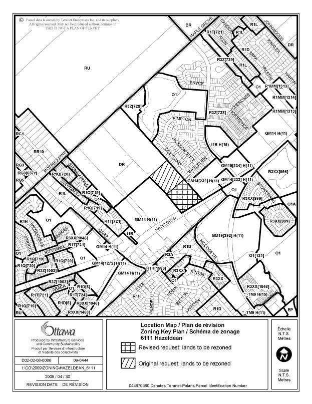
The lands affected by the requested by-law amendment are the southerly portion of 6111 Hazeldean Road, which is located on the north side of Hazeldean Road, between Carp Road and Stittsville Main Street. The property extends from Hazeldean Road north to the Maple Grove Road allowance.
The property has a frontage of 162.2 metres and a total area of 12.7 hectares, although only the southerly portion of the property is affected by this application. The subject site is currently vacant. To the east of the site is a commercial plaza known as the Jackson Trails Centre, which fronts onto Hazeldean Road. This shopping centre has several retail stores. To the north of the commercial plaza is the Jackson Trails residential subdivision. The property to the west of the subject site is a vacant parcel that is also zoned for commercial development. The northerly portion of the property is unaffected by this application. The applicant expects to develop this portion of the property as a residential subdivision at a later date, and would submit a separate application for by-law amendment together with the subdivision application. Lands on the south side of Hazeldean Road are occupied by several vacant buildings and parking lots previously used for the Stittsville Flea Market, and zoned for commercial development. No site plan application has been submitted for these lands.
Purpose of Zoning By-law Amendment
The purpose of the Zoning By-law amendment is to rezone the southerly portion of the subject property to permit development of a shopping centre consisting of multiple retail units.
The entire subject property is currently zoned Development Reserve Zone (DR) under City of Ottawa By-law 2008-250. This zone permits only limited non-residential uses such as an agricultural use or community garden, which will not preclude future development options. It is used to recognize lands intended for future urban development in areas designated as General Urban Area and Developing Communities in the Official Plan.
It is
proposed to rezone the subject property from Development Reserve Zone (DR) to
General Mixed-Use Exception Holding Zone (GM[xxxx]H(11)-h). The General
Mixed-Use Zone permits a range of commercial uses including a bank, restaurant,
retail store, medical facility, personal service business, recreational
facility, office and day care centre. A height limit of 11 metres would be in
effect. The site-specific exception denotes that a Holding Zone is applicable,
with the following conditions to be satisfied prior to removal of the holding
(h) symbol:
(a)
It has
been demonstrated that the Jackson Trails Pumping Station has sufficient
capacity to accept flows from the 6111 Hazeldean Road development to the
satisfaction of the City: and
(b)
It has
been demonstrated that sufficient capacity downstream of the Jackson Trails
Pumping Station is available for the 6111 Hazeldean Road development.
Revisions to Original Application
In the original rezoning application submitted in July 2008, the applicant requested that the southerly half of the site be rezoned to General Mixed-Use Zone with the depth of the commercial land to be approximately 329 metres. The depth of the commercial zone requested would have been aligned with the northerly boundary of the General Mixed-Use Zone (GM14H(11)) affecting the abutting property to the west. The applicant stated that aligning the northern boundaries of the sites would create opportunity to provide connectivity between the adjacent commercial properties.
The easterly boundary of the subject site abuts the residential properties in the Jackson Trails subdivision, and the extent of the commercial zone requested would have been directly adjacent to 12 residential properties located on the west side of Overland Drive, north of Bandelier Way. Planning staff were not in support of this extent of commercially zoned land, with the depth of the commercial zone proposed being approximately twice the depth of the Jackson Trails Plaza located directly to the east. The proposal generated community opposition from the residents of Overland Drive, whose properties would have backed onto the commercial development.
In March 2009, the proponent agreed to alter the extent of the commercial lands requested, as a means of addressing staff and residents’ concerns generated by the initial rezoning concept. The compromise proposed in the amended rezoning request significantly reduced the amount of land affected by the application, to approximately half of what was initially requested. The revision proposed that the commercial zoning extend only slightly beyond the northerly limit of the abutting Jackson Trails plaza, and be aligned with the southerly limit of Bandelier Way. The proposed commercial zone is approximately 30 metres deeper than the Jackson Trails plaza, but the additional depth was requested to compensate for the narrower frontage of the parcel and provide more flexibility in the design of the site layout and allow space for buffering along the northerly limit of the site, abutting future residential development. The extent of the lands affected by the both the original rezoning request and the amended request are illustrated on Document 1.
DISCUSSION
The Official Plan designates the
property General Urban Area. The
General Urban Area designation permits the development of a full range and
choice of housing types to meet the needs of all ages, incomes and life
circumstances, in combination with conveniently located employment, retail, service,
cultural leisure and institutional uses, in order to facilitate the development of complete and
sustainable communities. A broad range of uses is found within this
designation, from ground-oriented single-purpose to multi-storey mixed-use; and
from corner store to shopping centre. The Official Plan states that the City
will encourage the provision of small locally oriented service and convenience
uses that complement nearby residential areas.
The proposed Zoning By-law amendment will satisfy this intent by permitting a range of commercial uses and providing the surrounding neighbourhood with local services and shopping opportunities.
Compatibility with Official Plan
When
evaluating compatibility of development applications, the City refers to the
policies in Section 4 of the Official Plan. Section
4.11 sets out policy criteria to evaluate development compatibility in reviewing planning
applications, in terms of how the development relates
to scale in the context of existing surrounding area developments. The proposal to rezone the property from Development Reserve to a
General Mixed-Use zone is compatible with the policies in Section 4.11 of the
Official Plan. The following is a list of compatibility criteria that have been
evaluated in a preliminary manner. A more detailed review will be undertaken at
the time of Site Plan Control Approval:
Traffic and Vehicular
Access: Hazeldean Road is an urban arterial road adequately serving the
development, and has the ability to accommodate traffic generated by users of
the site. A Transportation Impact Study was reviewed and detailed road
modifications will be identified at the time of Site Plan Control Approval. In
addition, the widening of Hazeldean Road to four lanes is scheduled to take
place within the next few years, with the first phase being from Terry Fox
Drive to Huntmar Road, and the second phase from Huntmar Road to Carp Road.
Parking
Requirements: The development will have adequate on-site parking to satisfy
by-law requirements, eliminating the potential of spillover parking.
Building Height and
Massing: The buildings along this part of Hazeldean Road contribute to the
developing streetscape. The area is comprised of primarily commercial
development, and the proposed buildings will be developed with the intent of
continuing the pattern in terms of mass, height and planned function. The
height limit of 11 metres is consistent with that applicable to the surrounding
lands.
Outdoor
Amenity Areas: The intent is that development should respect the privacy of
outdoor amenity areas of adjacent residential units and minimize any
undesirable impacts. Due to neighbours’ concerns, the rezoning application was
modified, so that the lands adjacent to the Overland Drive homes do not form
part of the lands proposed for commercial development.
Loading/Service
Areas and Outdoor Storage: The operations and visual appearance of loading
facilities, service areas, parking and areas for outdoor storage should be
mitigated. The proposed commercial development does not abut any existing
residential lots. At the time of Site Plan Control Approval, service areas will
be located so as to minimize impact on future residential areas nearby.
Lighting, Noise and Air
Quality: The potential for light spill over from any lighting source onto
adjacent areas should be avoided. The lands adjacent to the Overland Drive
homes no longer form part of the lands proposed for commercial development. The
proposed development will not generate excessive noise, odours and other
emissions. Through the Site Plan Control Approval process, the use of
screening, landscaping and other measures will be considered in order to
respect any adjacent residential properties that may be developed in a future
subdivision.
The proposed use, when
evaluated against the above-noted compatibility criteria, is compatible with
the existing uses adjacent to the property. The proposed use will fit well
within the physical character of Hazeldean Road and will work well among the
other, similar uses in the immediate vicinity. The proposed zoning amendment
conforms to the compatibility criteria of Section 4.11 of the Official Plan.
Zoning
The
proposed by-law amendment would rezone the affected lands to General Mixed-Use
Zone. This proposal would amend the
zoning on the subject property to General Mixed-Use Zone, which allows a range
of uses including animal hospital, bank, day care centre, medical facility,
office, recreational and athletic facility, restaurant, retail store, and
retail food store. A range of residential uses such as mid-rise apartment
dwelling, retirement home and stacked dwelling are also permitted.
The
proposed zoning will be consistent with the zoning of other nearby properties
on both sides of Hazeldean Road. The properties
directly to the east, west and south of the subject site are zoned in a similar
manner, with variations of General Mixed-Use, Subzone 14 (GM 14), in the Zoning By-law. The vacant
properties to the west and south are zoned GM14, a Subzone that prohibits
retail store and retail food store, and permits a range of automobile-oriented
uses. The Jackson Trails Plaza to the east was subject to a site-specific
by-law amendment to include retail store and retail food store within that GM14
Zone. The request to rezone this
property to a similar zone will continue the pattern of development along
Hazeldean Road. The permitted uses for the General Mixed-Use zone requested
would be compatible with the surrounding zones, and the permitted uses will
further serve the growing residential community. The proposed height limit of
11 metres is consistent with that applicable to the surrounding lands.
The proposed northerly limit of the commercial zone would be aligned with the southerly edge of Bandelier Way in the adjacent Jackson Trails subdivision. The proposed commercial zone is approximately 30 metres deeper than the Jackson Trails plaza, but the additional depth compensates for the narrower frontage of the parcel and provides more flexibility in the design of the site layout and allows space for buffering along the northerly limit of the site, abutting future residential development. This is an appropriate demarcation point that allows for the extension of Bandelier Way into a future residential subdivision on the northerly portion of the subject property. The proposed commercial lands do not directly abut the most westerly residential lot on the south side of Bandelier Way, as the Jackson Trails subdivision included a six-metre walkway block at the westerly limit of Bandelier Way to provide pedestrian access to the commercial blocks along Hazeldean Road.
At the time of the Site
Plan Control application for the Jackson Trails Centre, commercial development
of the subject lands was anticipated, and the site plan agreement for that
plaza specified a shared vehicular access and conditions for cost-sharing
associated with the possible upgrading and signalization of the intersection at
a future date. The requested zoning is compatible with the zoning of
surrounding properties, and will permit a development comparable to the
adjacent development. A Site Plan Control application
was not provided concurrently with this application and will be submitted at a
later date.
Hazeldean
Road is classified as an existing arterial road in the Official Plan. Arterial
roads are the major roads that carry large volumes of traffic over the longest
distances, and function as major public corridors in the urban communities they
traverse. Hazeldean Road functions as a thoroughfare between Kanata and
Stittsville, and has
the potential to provide surrounding neighbourhoods with a central commercial
street, providing local services and shopping.
A Transportation Impact Study for the rezoning application was submitted in accordance with the Council’s approved Transportation Impact Assessment. The study addressed the introduction of traffic from the proposed development into the overall transportation network of the existing community. It was determined that the traffic generated by the proposed development can be accommodated, once certain roadway modifications are in place. A detailed review of the required road modifications required would be addressed in detail at the time of Site Plan Control review.
Infrastructure
issues regarding servicing of this site have been identified. The sanitary
system flows from this site are to outlet into the new Jackson Trails pumping
station. There is a limited amount of capacity available for these lands in
both the pump station and the sewers downstream of this site. The ultimate
sanitary outlet for this area, the Kanata West Pumping Station and forcemain,
has yet to be constructed. Distribution of any interim capacity is to be
determined at the site plan application stage. This site is also affected by
the requirements for Ontario Water
Resources Act applications as set out in the September 5, 2008 letter from
Environmental Assessment and Approvals Branch, to the City of Ottawa. The
applicant will have to provide a rationale as to why the proposed works will
not have an impact on the Carp River.
Because of the uncertainty
regarding the servicing capacity for this site, it is recommended that a
Holding Zone be placed on the lands until the sanitary distribution issues are
resolved. The Holding Zone would denote that development could not occur until
such time as sufficient sanitary capacity for development of the site has been
allocated.
Details of Proposed Zoning
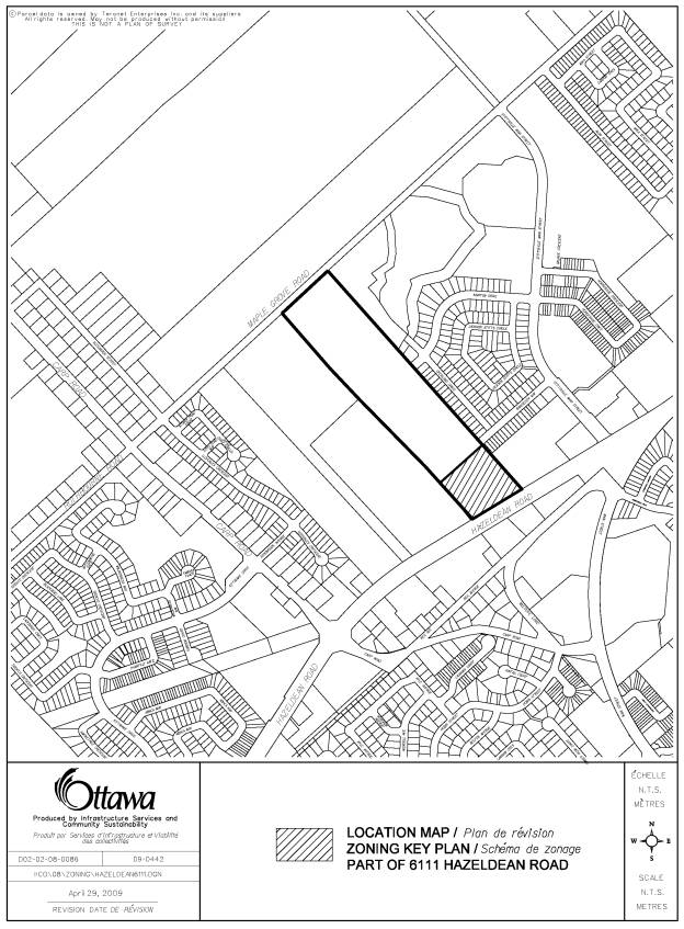
To change the zoning of the southerly portion of 6111 Hazeldean Road from Development Reserve Zone (DR) to General Mixed-Use Exception Holding Zone (GM[xxxx]H(11)-h) as shown in Document 2 and as detailed in Document 3.
Conclusions
This proposed Zoning By-law amendment will allow development of a new commercial centre compatible with the surrounding area. Large portions of the surrounding lands are zoned in a similar manner, so the development permitted will be compatible in size with future adjacent development, and will be subject to similar provisions and development standards with respect to yard setbacks, coverage, and building height. The proposal makes use of existing services, and is supportive of transit and pedestrian use, and the reduction in size of the proposed lands to be rezoned addresses community concerns and facilitates compatibility. The proposed permitted uses are therefore considered appropriate for the site and respect the existing character of the community.
ENVIRONMENTAL IMPLICATIONS
The rear portion of the property is included within Urban Natural Area 29 (North of Hazeldean) identified in the Urban Natural Areas Environmental Evaluation Study. This study was undertaken to assess the relative environmental value of natural areas in the urban area to establish priorities and make recommendations for management of these lands. During the Urban Natural Areas Environmental Evaluation Study, the landowners of this and other affected properties denied access to their property, and no evaluation of the natural area was completed. Therefore the Urban Natural Features Strategy approved by City Council in 2007 indicated for that UNA 29, an Environmental Impact Statement would be required at the time of a development application to determine the environmental value of these sites and to inform future decisions. The Environmental Impact Statement will be required at the time of site plan control application.
CONSULTATION
Notice of this application was carried out in accordance with the City's Public Notification and Consultation Policy. The Ward Councillor is aware of this application and is in support of the staff recommendation. The public comments and staff response are detailed in Document 4.
LEGAL/RISK MANAGEMENT IMPLICATIONS:
There are no legal/risk management implications associated with this report.
FINANCIAL IMPLICATIONS
APPLICATION PROCESS TIMELINE STATUS
The application was not processed by the "On Time Decision Date" established for the processing of Zoning By-law amendments for several reasons: the application was On Hold for several months while the applicant considered revisions to the proposal, and further time was required for issue resolution.
SUPPORTING DOCUMENTATION
Document 1 Location Map (Original and Revised Lands Affected)
Document 2 Location Map (Lands Affected )
Document 3 Details of Recommended Zoning
Document 4 Consultation Details
DISPOSITION
City Clerk and Legal Services Branch, Legislative Services to notify the owner, McGuire Advisors Inc., 2009 Hollybrook Crescent, Ottawa, Ontario K1J 7Y5; applicant, Novatech Engineering Consultants Ltd., 240 Michael Cowpland Drive, Kanata, Ontario K2M 1P6, Attention: Ms Alyson Mann; OttawaScene.com, 174 Colonnade Road, Unit #33, Ottawa, ON K2E 7J5, Ghislain Lamarche, Program Manager, Assessment, Financial Services Branch (Mail Code: 26‑76) of City Council’s decision.
Planning and Growth Management Department to prepare the implementing by-law, forward to Legal Services and undertake the statutory notification.
Legal Services to forward the implementing by-law to City Council.
ORIGINAL AND REVISED REZONING REQUEST DOCUMENT 1
LOCATION MAP: LANDS TO BE REZONED DOCUMENT 2
DETAILS OF RECOMMENDED ZONING DOCUMENT 3
Proposed changes to By-law 2008-250:
1. The lands shown on Document 2 zoned DR under By-law 2008-250 will be rezoned to GM[xxxx]H(11)-h.
2. Section 239 of By-law 2008-250 is amended to add a new exception including the following provisions:
The
following conditions must be satisfied prior to removal of the holding (h)
symbol:
(a) It has been demonstrated that the
Jackson Trails Pumping Station has sufficient capacity to accept flows from the
6111 Hazeldean Road development to the satisfaction of the City: and
(b) It has been demonstrated that
sufficient capacity downstream of the Jackson Trails Pumping Station is
available for the 6111 Hazeldean Road development.
CONSULTATION DETAILS DOCUMENT 4
NOTIFICATION AND CONSULTATION PROCESS
Notification and
public consultation was undertaken in accordance with the Public Notification
and Public Consultation Policy approved by City Council for Zoning By-law
amendments. The following is a synopsis of public comments received and the
staff response to comments. Comments from several members of
the public were received, stating opposition to the proposal as originally
circulated.
SUMMARY OF PUBLIC INPUT
Extent of Commercial Zone
The residents’ concerns dealt with the introduction of a commercial zone abutting the residential development in the Jackson Trails community, particularly as it affected the detached homes on the west side of Overland Drive that would have backed onto the proposed commercial development. Residents were aware that the land behind the Overland Drive properties would be rezoned for development, but expected this land to be developed as a residential subdivision. The comments received reflected the opinion that commercial development immediately to the rear of their properties would be incompatible with the residential use, and negatively impact enjoyment of their rear yards, by creating a visual intrusion, as well as noise and light pollution. There was a general consensus among the respondents that the commercial zoning should not extend much farther north than the existing Jackson Trails plaza.
Response
The subject rezoning proposal has been scaled back significantly and now proposes a commercial zone that is approximately half the depth of that originally proposed. The northerly limit of the proposed General Mixed-Use Zone aligns with the southerly limit of Bandelier Way in the adjoining Jackson Trails subdivision, and the zone does not abut any residential lots on Overland Drive. The proposed commercial zone is approximately 30 metres deeper than the Jackson Trails plaza, but the additional depth compensates for the narrower frontage of the parcel and provides more flexibility in the design of the site layout and allows space for buffering along the northerly limit of the site, abutting future residential development.
COUNCILLOR’S COMMENTS
Councillor Qadri is aware of the application and the staff recommendation.