Report to/Rapport au :
Planning and Environment Committee
Comité de l'urbanisme et de l'environnement
and Council / et au Conseil
01 October 2008 / le 01 octobre 2008
Submitted by/Soumis par : Nancy Schepers, Deputy City Manager
Directrice municipale adjointe
Planning, Transit and the Environment
Urbanisme, Transport en commun et Environnement
Contact
Person/Personne Ressource : Grant Lindsay, Manager/Gestionnaire,
Development Approvals/Approbation des demandes d'aménagement, Planning
Branch/Direction de l’urbanisme
(613)
580-2424, 13242 Grant.Lindsay@ottawa.ca
SUBJECT: |
Official Plan and ZONING - 30 Goulbourn Forced Road
(FILE NO. d01-01-06-0017 and D02-02-06-0098) |
|
|
OBJET : |
REPORT RECOMMENDATION
That the recommend Council:
1.
Approve and adopt an amendment to the
Kanata Town Centre Site-Specific Policies in Volume 2-B of the Official Plan to
redesignate 30 Goulbourn Forced Road from "LDE" (Low Density
Employment Area) to "LDE-5" (Low Density Employment Area - Special Policy
Area 5)", as
detailed in Document 4.
2.
Approve an amendment to Zoning By-law 2008-250 to
change the zoning of 30 Goulbourn Forced Road from “IL7[307]-h” (Light
Industrial Subzone 7, Exception 307, Holding) to "IL7[xxxx]-h" (Light Industrial Subzone 7, Exception xxxx,
Holding), as shown in Document 1 and detailed in Document 5.
3.
Approve an amendment to the former City of Kanata
Zoning By-law 142-93 to change the zoning of 30 Goulbourn Forced Road from
“M1C-1(H)” (Light Industrial, Mixed, Exception 1, Holding) to “M1C–x(H)” (Light
Industrial, Mixed, Exception x, Holding), as shown in Document 1 and detailed
in Document 5.
RECOMMANDATION DU RAPPORT
Que le Comité de recommande au Conseil :
1.
d’approuver
et d’adopter une modification aux politiques sur les sites particuliers du
centre-ville de Kanata décrites dans le volume 2-B du Plan officiel de la Ville
d’Ottawa pour faire passer la désignation du 30, chemin Goulbourn Forced de
« LDE » – secteur d’emploi à faible densité – à
« LDE-5 » – secteur d’emploi à faible
densité – zone de dérogation 5, comme le précise le document 4.
2.
d’approuver
une modification au Règlement municipal de zonage 2008-250 pour faire passer le
zonage du 30, chemin Goulbourn Forced de
« IL7[307]-h » – sous zone d’industrie légère 7, assortie
de l’exception 307, aménagement différé – à
« IL7[xxxx]-h » – sous zone d’industrie légère 7, assortie
de l’exception xxxx, aménagement différé, comme l’illustre le document 1 et le
précise le document 5.
3.
d’approuver
une modification au Règlement municipal de zonage 142-93 de l’ancienne Ville de
Kanata pour faire passer le zonage du 30, chemin Goulbourn Forced de
« M1C-1(H) » – zone d’industrie légère mixte, assortie de
l’exception 1, aménagement différé – à
« M1C-x(H) » – zone d’industrie légère mixte, assortie de
l’exception x, aménagement différé, comme l’illustre le document 1 et le
précise le document 5.
BACKGROUND
Site Context
The subject property is located at 30 Goulbourn Forced Road at the northwest corner of the Terry Fox Drive and Highway 417 interchange within the Kanata Town Centre, as shown in Document 1. The site is bounded by Terry Fox Drive to the east, Highway 417 to the south, and Goulbourn Forced Road to the west. The site is currently vacant and has an area of 1.9 hectares. Existing conditions include trees and bush located on the northern portion of the property and around the perimeter of the site. An overhead hydro line and poles are located on the east and south sides of the site.
Immediately to the north of the site is an unopened road allowance for Earl Grey Drive, which is to be extended west from Kanata Centrum underneath Terry Fox Drive to connect with Goulbourn Forced Road. Further to the north are lands developed with a gas station, convenience store and car wash. To the east across Terry Fox Drive is the Kanata Centrum shopping centre, and to the south across Highway 417 is a Costco warehouse membership club. A Ministry of Transportation works yard and vacant lands proposed to be developed with a six-storey self-storage building and retail uses are located to the west of the site across Goulbourn Forced Road.
Development Proposal
In September 2005, the applicant
submitted a site plan application to permit a single-storey retail building in
the southern portion of the site with a gross floor area of 4705 square
metres. The retail building is to be
used for one or more retail warehouse and/or retail store uses. In July 2006, the applicant filed Official
Plan amendment and Zoning By-law amendment applications to add a retail store
as a permitted use, to change the parking provisions, and to reduce the front
yard setbacks. In January 2007, the
applicant appealed all three applications to the Ontario Municipal Board on the
basis that the applicable approval authorities did not make decisions on the
applications within the prescribed timelines in the Planning Act.
In August 2007, the Official Plan and Zoning By-law amendment applications were amended to reflect a new development concept that relocates the proposed retail building to the northern portion of the site, and adds a 30-storey office/hotel building, a 24-storey apartment building, and a five-storey above-grade parking garage in the southern portion of the site. A conceptual site plan and bird’s eye view of the revised development proposal are shown in Documents 2 and 3, respectively.
The office and hotel uses are proposed in the southern 30-storey tower located closest to Highway 417. This tower will have a gross floor area of 28506 square metres including 10745 square metres of office space and an estimated 264 hotel rooms. The apartment building is proposed to be located in the northern 24-storey tower, and is planned to contain 179 dwelling units and a gross floor area of 19345 square metres. The roof of the parking garage is to be used as an outdoor amenity area. The revised development proposal also increases the gross floor area of the retail building slightly from 4705 square metres to 4999 square metres. Four driveways are proposed to provide vehicular access to Goulbourn Forced Road.
The site is bisected by the future east-west transitway, which is proposed to extend westerly from Terry Fox Station at Kanata Centrum to Scotiabank Place and south to Hazeldean Road. The portion of the proposed transitway extension between Terry Fox Drive and Goulbourn Forced Road is to be situated below grade. The applicant proposes to construct a tunnel for the rapid transit corridor through the site, and to construct the retail building above the tunnel.
The development is to be constructed in three phases. Phase 1 will include the construction of the retail building, the rapid-transit corridor tunnel, and the ground level of the parking garage. Phases 2 and 3 would involve the construction of the 30-storey office/hotel tower and the 24‑storey apartment building, respectively, and the completion of the parking garage.
The applicant has not resolved the traffic issues associated with the full development proposal, and has now requested that staff proceed with a recommendation on the proposed Phase 1 development only. Therefore, the analysis and recommendations in this report are focused on the parts of the Official Plan and Zoning By-law amendment applications that relate to the Phase 1 development only. A separate report and recommendations will be prepared at a later date to address the Phase 2 and 3 proposals.
Purpose of Phase 1 Official Plan Amendment Application
The site is
designated in the Official Plan as a “Mixed-Use Centre” with a “Town Centre”
overlay, and as “LDE” (Low Density Employment) in the Kanata Town Centre
Site-Specific Policies. The purpose of
the Phase 1 Official Plan amendment application is to amend the Low Density
Employment policies to add a retail store as a permitted use.
Purpose of Phase 1 Zoning By-law Amendment Application
The site is zoned “IL7[307]-h” (Light Industrial Subzone 7, Exception 307, Holding) in Comprehensive Zoning By-law 2008-250. The permitted uses in this zone include a hotel, office uses, light industrial uses, restaurants, and a limited range of retail store uses. Specifically, retail stores are limited to the sale of specific products such as furniture, appliances, flooring, paint, doors, windows, etc., and are restricted to a minimum gross floor area of 1858 square metres and a maximum gross floor area of 4999 square metres. The zoning prohibits retail stores until the holding symbol has been lifted. The conditions to lift the holding symbol include the submission of a traffic study, a market study, and a complete site plan application. The zoning permits a maximum building height of 13.5 metres.
The site is zoned “M1C-1(H)”
(Light Industrial, Mixed, Exception 1, Holding) in the former City of Kanata
Zoning By-law 142-93. The permitted
uses and zone provisions for the “M1C-1(H)” zone are similar to those for the
“IL7[307]-h” zone. In contrast to
Comprehensive Zoning By-law 2008-250, the former City of Kanata Zoning By-law
142-93 uses the term “retail warehouse” to generally describe a retail store
with a 1858 to 4999 square metres of gross floor area.
The purpose of the Phase 1 Zoning
By-law amendment application is as follows:
1)
To lift
the holding zone symbol to permit retail store and retail warehouse uses;
2)
To remove
the limitations on the type of products sold in a retail store;
3)
To permit
a retail store with a gross floor area of less than 1858 square metres;
4)
To permit
retail store and retail warehouse uses with a density greater than 2298 square
metres of gross floor area per development hectare;
5)
To reduce
the minimum front yards not abutting Highway 417 from 12 metres to
0.0 metres;
6)
To
require a minimum parking rate of 2.3 parking spaces per 100 square metres of
floor area for retail store and retail warehouse uses;
7)
To ensure
that the site is considered as one lot for zoning purposes; and
8)
To reduce
the minimum length of a parking space from 6.0 metres to 5.2 metres, and to
increase the minimum two-way drive aisle width from 6.0 metres to 6.7 metres in
the former City of Kanata Zoning By-law, which are the same standards used in
Comprehensive Zoning By-law 2008-250.
DISCUSSION
The Official Plan
designates the site as a Mixed-Use Centre with a Town Centre overlay. The Mixed-Use Centre designation identifies
areas that are strategically located with respect to the transportation system
and are accessible by transit, walking, cycling and automobile. Mixed-Use Centres are centered on rapid transit
stations and contain one or more arterial roads with all-day frequent transit
service. The site is located near
Highway 417 and two arterial roads - Terry Fox Drive and Campeau Drive. Terry Fox Station, which is part of the
Transitway, is located about 620 metres to the east of the site.
The Mixed-Use Centre
designation permits a broad variety of uses and encourages transit-supportive
land uses such as offices, secondary and post-secondary schools, hotels,
hospitals, large institutional buildings, community recreation and leisure
centres, daycare centres, retail uses, entertainment uses, services (such as
restaurants), high and medium-density residential uses and mixed-use
development. It is noted that the
Mixed-Use Centre policies permit retail uses without any restrictions on the
size of individual uses and the type of products sold.
The Town Centre
overlay identifies Mixed-Use Centres that are planned to accommodate at least
10000 jobs.
The Official Plan
identifies a “Future Rapid Transit Corridor (Alignment to be Defined)” crossing
the site. This designation extends from
Terry Fox Station to future stations planned in Kanata West including one at
Scotiabank Place. The subject lands are
within the study area for the East-West Light Rail Transit Corridor
Environmental Assessment, which was initiated and then suspended by City
Council pending the completion of the Transportation Master Plan update. The
rapid transit corridor identified on the conceptual site plan is in accordance
with preliminary functional plans prepared for the corridor. However, the final alignment, profile, and
width for the rapid transit corridor will need to be determined prior to the
construction of the Phase 1 development.
Preliminary functional plans prepared for the corridor initially contemplated a below-grade, uncovered rapid transit corridor through the site. The applicant is proposing that a tunnel be used through the site instead, which would allow for the construction of the retail building above the rapid transit corridor. While the proposed tunnel may provide an acceptable alternative to the City's initial uncovered tunnel corridor concept, its acceptability to the City will depend on the applicant entering into agreements with the City ensuring:
· the tunnel's location and its design are acceptable, functional, and compatible with all future City expectations and requirements for rapid transit, including its cost, operation, maintenance and replacement, both in the short term and the long term;
· the applicant agreeing to pay all additional internal and external costs incurred by the City for its design of a tunnel, versus an uncovered tunnel corridor, including construction, operation, maintenance and life cycle replacements, and the City's administration of all of these elements; and
·
the applicant agreeing to pay market value or its
equivalent in community benefits for any and all air rights, required by the
applicant, as well as any and all other property rights it might require from
the City.
Kanata Town Centre
Site-Specific Policies
The Kanata Town
Centre is also subject to site-specific policies found in Volume 2-B of the
Official Plan. These policies set an
employment target of at least 12500 jobs for all of the lands in the Town
Centre, which is higher than the target of 10000 jobs under the Mixed Use
Centre – Town Centre policies. Most of
the employment target is intended to be achieved by the future development of
office uses within the “Central Business District” and “Main Street”
designations, which are located to the east of the “Regional Shopping Centre”
designation (Kanata Centrum). The
proposed Phase 1 development will add retail jobs to the Kanata Town Centre,
and will not affect future office development in the Central Business District
and Main Street areas.
The Kanata Town Centre
Site-Specific Policies designate the site as a Low Density Employment
Area. This designation permits
restricted industrial uses, offices, automotive commercial uses, large retail
warehouses, retail warehouses, business park retail outlets, planned retail
centres, accessory commercial development, and home renovation uses. It is noted that the retail warehouse, large
retail warehouse, and planned retail centre uses are only permitted subject to
certain policies. For example, the
policies require the use of a holding symbol in the implementing Zoning By-law
to prohibit retail warehouses until a traffic study, a market study, and a site
plan application are submitted. In
addition, large retail warehouses are only permitted through a Zoning By-law
amendment supported by a traffic study and market study.
While the Mixed-Use
Centre policies permit a full range of retail uses, the Low Density Employment
Area policies only permit a limited range of retail uses. In particular, some of the permitted retail uses
are restricted in size to large format retail warehouses with a minimum gross
floor area of 1858 square metres and a maximum gross floor area of 4999 square
metres. Smaller retail stores with a
gross floor area of less than 1858 square metres are not permitted in this
designation. To permit an expanded
range of retail uses as requested by the applicant, a site-specific Official
Plan amendment is required to add a retail store as a permitted use in the Low
Density Employment Area designation.
The retail policies
for the Low Density Employment Area were introduced when the Kanata Regional
Shopping Centre was in the early stages of development. The general purpose of the policies was to
foster the expansion of the Regional Shopping Centre and protect its planned
function, while still allowing some large format retail uses to be developed in
the Low Density Employment Area.
Specifically, a market study was required to permit a retail warehouse
in the Low Density Employment Area until the Regional Shopping Centre reached a
gross leasable area of 50000 square metres; and a large retail warehouse was
not permitted until the Regional Shopping Centre reached 50000 square metres in
size. The Regional Shopping Centre now
exceeds this size.
Given the relatively
small size of the proposed retail building compared to the current size of the
Regional Shopping Centre, the proposal to expand the range of permitted retail
uses is unlikely to have a significant impact on the Regional Shopping Centre
and will not undermine its planned function.
Therefore, it is no longer necessary to restrict the type and size of
retail uses permitted at 30 Goulbourn Forced Road. The proposed form for the retail building and the range of
requested retail uses are also compatible with the existing retail and service
commercial uses in the immediate area.
Traffic Impact Study
The Kanata Town Centre site-specific policies set out certain conditions that need to be satisfied prior to lifting the holding symbol in the implementing Zoning By-law amendment to permit a retail warehouse use. One of the conditions is for the applicant to submit a traffic study that identifies the roadway/intersection modifications required to support the scale of development proposed.
The applicant has submitted two traffic impact studies. The first study was submitted in support of the original proposal to permit a retail building with a gross floor area of 4705 square metres. The applicant did not respond to the City’s comments on the first traffic study, and the study was not accepted. A second traffic impact study was submitted to support the revised proposal to permit the full development of the site including retail, apartment, and office/hotel buildings. Transportation staff have advised that based on the projected Saturday peak hour traffic volumes, the intersection of Terry Fox Drive and Goulbourn Forced Road cannot support the full development of the site together with other proposed developments in the area based on the existing road network.
The Department has initiated a needs assessment for Terry Fox Drive between Highway 417 and Campeau Drive to determine the long-term road network modifications that would be needed to support existing and proposed development in the area. In particular, the needs assessment will review the road network with/without the following: 1) the proposed Terry Fox Drive/Earl Grey Drive underpass; 2) the widening of Terry Fox Drive from four to six lanes between Campeau Drive and Hazeldean Road; 3) the application of various movement restrictions at the Terry Fox Drive and Goulbourn Forced Road intersection; and 4) the potential extension of Goulbourn Forced Road along the north side of Highway 417 to connect to Didsbury Road.
With respect to potential timing, the 2008 Council Approved Budget allocates a total of $13 million to the Terry Fox Drive underpass project with design anticipated to commence in 2009 and construction anticipated in 2010. The widening of Terry Fox Drive from four to six lanes between Campeau Drive and Hazeldean Road is included as a project in the Development Charges Background Study, but is not identified in the 2008 to 2017 time horizon of the Council Approved Budget.
The applicant intends to submit a revised traffic impact study for the Phase 1 development after the needs assessment has been submitted to the satisfaction of the City, and after the subject Official Plan amendment and implementing Zoning By-law amendments have come into force. The Department has no objections to this approach provided that holding symbols are used in the applicable Zoning By-laws to prohibit retail store and retail warehouse uses until a revised traffic impact study has been submitted and approved.
The proposed Phase 2
and 3 developments would intensify the site well beyond the amount of
development permitted by the existing Low Density Employment Area policies and
the existing zoning. The Department
believes that it is premature to make recommendations on the proposed Phase 2
and 3 developments prior to the completion of the area transportation
review. In particular, the findings
from the transportation review may affect the recommended zoning provisions
such as the maximum density and/or the potential use of a holding symbol and
associated conditions that would need to be fulfilled prior to allowing more
intensive use of the site. Therefore,
staff intend to bring a separate report forward at a later date with
recommendations on the proposed Phase 2 and 3 developments following the
completion of the area transportation review.
Proposed Official Plan Amendment
Based on the
foregoing, the Department recommends redesignating the site from “LDE” (Low
Density Employment Area) to a new site-specific “LDE-5” (Low Density Employment
Area Special Policy Area 5) to add a retail store as a permitted use. As the applicant’s traffic study has not
been approved to support the proposed retail store use, the policies also
provide for the use of a holding symbol in the implementing Zoning By-laws to
prohibit a retail store until a traffic study identifying the
roadway/intersection modifications that are required to support the scale of
development proposed has been submitted and approved. This proposed policy is similar to the existing policy that
requires the use of a holding symbol to prohibit a retail warehouse until a
traffic study has been submitted. The
draft Official Plan amendment is included in Document 4.
Details of Recommended Zoning
Comprehensive Zoning By-law 2008-250
The proposed Zoning By-law amendment for the site is intended to accommodate the proposed Phase 1 development only. A separate staff report with zoning recommendations will be prepared later for the Phase 2 and 3 development. The proposed zoning amendment will rezone the site from an “IL7[307]-h” (Light Industrial Subzone 7, Exception 307, Holding) zone to a new, site-specific “IL7[xxxx]-h” (Light Industrial Subzone 7, Exception xxxx, Holding) zone. The details of the recommended zoning are described in Document 5 and summarized below.
The proposed “IL7[xxxx]-h” zone will permit all of the uses in the “IL7[307]-h” zone, and will remove the limitations on the type of products sold in a retail store. The proposed zone will also remove the minimum gross floor area of 1858 square metres that currently applies to a retail store.
The existing zoning permits retail store uses with a maximum density of 2298 square metres of gross floor area per development hectare. Based on the total lot area, the maximum size of retail store uses is 4386 square metres. The applicant is requesting zoning to permit a retail building with a gross floor area of 4999 square metres, which is 613 square metres or about 14 per cent greater than the maximum size currently permitted. The proposed size increase is small and will not create any significant traffic or planning impacts, and the Department does not have any objections to the density increase. To simplify the zoning provisions, the Department recommends deleting the density provision and adding a provision to permit a maximum aggregate gross floor area of 4999 square metres for retail store uses.
The applicant has requested that the holding symbol be removed from the zoning to permit retail store and retail warehouse uses. The existing conditions to lift the holding symbol include the submission of a traffic study, a market study, a complete site plan application, and any other information that the City requires. The traffic study condition continues to apply, as the applicant is required to submit a revised traffic study for the Phase 1 development for approval. The market study condition only applies until the Regional Shopping Centre designation exceeds 50000 square metres of gross floor area. As development in the Regional Shopping Centre designation now exceeds this amount, a market study is no longer required. The condition to submit a complete site plan application is unnecessary since one has already been submitted. It is recommended that the holding symbol be maintained, and that the conditions to lift the holding symbol be revised to only require the submission and approval of a traffic study to clarify that there is only one outstanding condition.
The applicant has requested a
reduction in the front yard and exterior side yard setbacks that do not abut
Highway 417 from 12 metres to 0.0 metres.
The Ministry of Transportation has advised that a minimum 14‑metre
building setback is required from Highway 417 and any ramps. Due to the location of a westbound on-ramp
that extends northwards adjacent to Terry Fox Drive, a 14‑metre setback
is required along the full length of the eastern lot line as well as the
southern lot line. The proposed zoning
specifies a minimum 14‑metre width for the yards adjacent to Highway 417
and Terry Fox Drive to reflect the Ministry of Transportations
requirements.
The Department does not have any
objections to reducing the minimum front yard along Goulbourn Forced Road to
0.0 metres to offset the relatively large setbacks required from Highway 417
and the on-ramp. The Phase 1 retail
building is proposed with the front elevation facing Highway 417 and with a
side elevation facing Goulbourn Forced Road.
The side elevation is across Goulbourn Forced Road from an existing
Ministry of Transportation works yard and a proposed self-storage
building. The proposed 0.0‑metre
setback for this side elevation is not anticipated to have an adverse impact on
these uses.
The retail store is proposed to
be oriented with the rear elevation facing north towards the future Earl Grey
Drive extension. In addition, a large
retaining wall with a height of about 4.85 metres is proposed immediately
adjacent to Earl Grey Drive, along the full length of the rear wall. The rear elevation and retaining wall will
be visible from Terry Fox Drive, Goulbourn Forced Road, and the future Earl
Grey Drive extension. The applicant has
requested a 0.0‑metre front yard setback from Earl Grey Drive. However, staff recommend that a minimum
three metre building setback be required adjacent to Earl Grey Drive to provide
sufficient space for landscape planting to buffer the view of the rear
elevation and retaining wall from the streets.
The applicant applied to reduce
the parking rate for a retail store and retail warehouse to a minimum of 2.3
parking spaces per 100 square metres of gross floor area. The parking rate required for a retail store
in Comprehensive Zoning By-law 2008-250 is 3.4 parking spaces per 100 square
metres of gross floor area for the Kanata area. The applicant has not provided details regarding the specific
type of retail use being proposed for the site, or a parking study to justify a
reduced parking rate. Staff are
concerned that the proposed parking rate may not be sufficient to accommodate
the parking demand for all types of retail uses that would be permitted under
the proposed zoning. In the absence of
any further supporting material, staff recommend maintaining a minimum parking
rate of 3.4 spaces per 100 square metres.
As requested by the applicant, the proposed zoning adds a provision to
treat the entire lot as one lot for zoning purposes. This is necessary to allow for the development of the proposed
retail store over the rapid transit corridor, which is to be transferred to the
City.
Former City of Kanata Zoning By-law 142-93
As the former City of Kanata Zoning By-law 142-93 is still in force, it is also proposed to amend this By-law to rezone the site from an “M1C-1(H)” (Light Industrial, Mixed, Exception 1, Holding) zone to a new, site-specific “M1C-x(H)” (Light Industrial, Mixed, Exception x, Holding) zone. The details of the recommended zoning are described in Document 5 and have the same intent as the IL7[xxxx]-h zone proposed for Comprehensive Zoning By-law 2008-250.
The applicant has applied to decrease the minimum length of a parking space from 6.0 metres to 5.2 metres, and to increase the minimum two-way drive aisle width from 6 .0 metres to 6.7 metres in the former City of Kanata Zoning By-law 142-93. These are the same parking standards found in Comprehensive Zoning By-law 2008-250. Staff have no objections to this request, and the recommended amendment to the former City of Kanata Zoning By-law 142-93 includes a site-specific exception to permit the modified parking dimensions.
The proposed Official Plan and Zoning By-law amendments will accommodate the applicant’s Phase 1 development, which includes the development of a retail building with a gross floor area of 4999 square metres. A separate report will be prepared later to address the 30-storey office/hotel building and the 24-storey apartment building proposed in Phases 2 and 3.
30
Goulbourn Forced Road is designated as a Mixed-Use Centre with a Town Centre
overlay in the Official Plan and as a Low Density Employment Area in the
Site-Specific Policies for the Kanata Town Centre. The Mixed-Use Centre policies permit a full range of retail
uses, while the Low Density Employment Area policies permit a limited range of
retail uses including large format retail warehouses. The applicant's request to permit an expanded range of retail
uses complies with the Mixed-Use Centre policies. The restrictions placed on the type and size of retail uses in
the Low Density Employment Area are no longer needed because the Kanata Centrum
Regional Shopping Centre now exceeds 50000 square metres of gross leasable
area. The location and size of the site
is suitable to accommodate the proposed expansion of the permitted retail uses,
and the uses are compatible with the surrounding land uses. The Department recommends redesignating the
site to a site-specific Low Density Employment Special Policy Area 5
designation, which adds a retail store as a permitted use. The proposed Official Plan amendment will
increase the range of permitted retail uses and provide greater flexibility for
the owner to lease the proposed Phase 1 retail space to potential tenants.
The
proposed Zoning By-law amendment will change the zoning of the site from an
"IL7[307]-h" (Light Industrial Subzone 7, Exception 307, Holding)
zone to a new site-specific "IL7[xxxx]-h" (Light Industrial Subzone
7, Exception xxxx, Holding) zone in Comprehensive Zoning By-law 2008-250; and
from an “M1C-1(H)” (Light Industrial, Mixed, Exception 1, Holding) zone to a
new site-specific “M1C–x(H)” (Light Industrial, Mixed, Exception X, Holding)
zone in the former City of Kanata Zoning By-law 142-93. The new zones will permit a retail store
without limitations on the type of products sold, and will delete the minimum
gross floor area for this use. The
proposed zoning also establishes a maximum aggregate gross floor area of 4999
square metres for retail store uses.
The proposed zones include holding symbols that prohibit retail stores
and retail warehouses until the holding symbols are lifted following the
submission and approval of a transportation impact assessment. The proposed zoning also includes
site-specific provisions for the minimum yard widths, parking area dimensions,
and parking rates.
Mississippi Valley Conservation has no objections to the applications.
CONSULTATION
Notice of these applications was carried out in accordance with the City's Public Notification and Consultation Policy. The Ward Councillor is aware of the applications and the staff recommendation. Comments from the Hazeldean-Katimavik Community Association on the applications are provided in Document 6.
FINANCIAL IMPLICATIONS
The application was not processed by the "On Time Decision Date" established for the processing of Official Plan and Zoning By-law amendments due to the complexity of the transportation impact and rapid transit corridor issues associated with the development. In addition, the applications were substantially revised following the initial application submission and appeals to the Ontario Muncipal Board to request amendments to permit the proposed Phase 2 and 3 developments.
SUPPORTING DOCUMENTATION
Document 1 Location Map
Document 2 Conceptual Site Plan
Document 3 Bird’s Eye View of Full Development Looking Northwest
Document 4 Proposed Official Plan Amendment
Document 5 Details of Recommended Zoning
Document 6 Consultation Details
City Clerk’s Branch, Council and Committee Services to notify the owner/applicant, Lisa Dalla Rosa, applicant, 1278792 Ontario Inc. c/o Richcraft Group of Companies, 2280 St. Laurent Boulevard, Ottawa, ON, K1G 4K1, Ghislain Lamarche, Program Manager, Assessment, Financial Services Branch (Mail Code: 26-76) of City Council’s decision.
Planning, Transit and the Environment Department to prepare the implementing by-law, forward to Legal Services Branch and undertake the statutory notification.
Legal Services Branch to forward the implementing by-law to City Council.
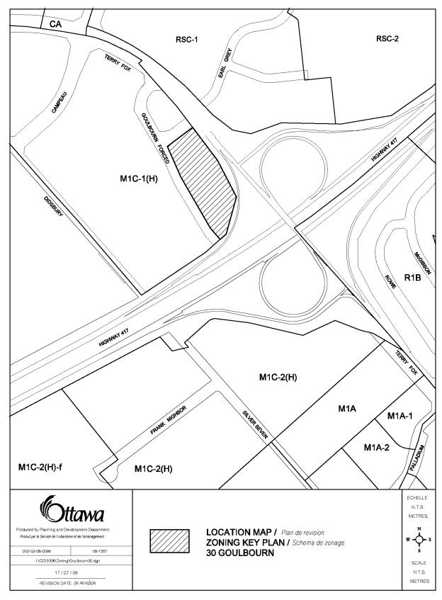
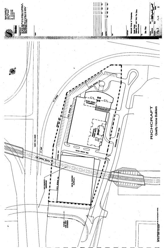
CONCEPTUAL SITE PLAN DOCUMENT 2
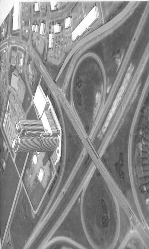
PROPOSED OFFICIAL PLAN AMENDMENT DOCUMENT 4
|
Official Plan Amendment xx
Modification du Plan directeur xx
To the
Official Plan for the City of Ottawa
AMENDMENT NO.
xx
OFFICIAL PLAN FOR THE CITY OF OTTAWA
Purpose...............................................................................................................................................
Location..............................................................................................................................................
Basis...................................................................................................................................................
PART B – THE AMENDMENT
Introduction.........................................................................................................................................
Details.................................................................................................................................................
Part A - The Preamble introduces the actual amendment, but does not constitute part of Amendment No. xx to the Official Plan for the City of Ottawa.
Part B - The Amendment, consisting of the following text and map attached as Schedule “A” constitutes Amendment No. xx to the Official Plan for the City of Ottawa.
PART A - THE PREAMBLE
1. Purpose
The subject property, municipally known as 30 Goulbourn Forced Road, as shown on Schedule “A”, is designated “Mixed-Use Centre” with a “Town Centre” overlay in the Official Plan. The Site-Specific Policies for the Kanata Town Centre, found in Volume 2-B of the Plan, designate the site as a “LDE” (Low Density Employment Area). The purpose of Amendment No. xx is to redesignate 30 Goulbourn Forced Road from “LDE” (Low Density Employment Area) to “LDE-5” (Low Density Employment Area, Special Policy Area 5) to add a retail store as a permitted use.
2. Location
The subject property is located at 30 Goulbourn Forced Road at the northwest corner of the Terry Fox Drive and Highway 417 interchange within the Kanata Town Centre, as shown in Document 1. The site is bounded by Terry Fox Drive to the east, Highway 417 to the south, and Goulbourn Forced Road to the west. The site is currently vacant and has an area of 1.9 ha. Existing conditions include trees and bush located on the northern portion of the property and around the perimeter of the site. An overhead hydro line and poles are located on the east and south sides of the site.
Immediately to the
north of the site is an unopened road allowance for Earl Grey Drive, which is
to be extended west from Kanata Centrum underneath Terry Fox Drive to connect
with Goulbourn Forced Road. Further to
the north are lands developed with a gas station, convenience store and car
wash. To the east across Terry Fox
Drive is the Kanata Centrum shopping centre, and to the south across Highway
417 is a Costco warehouse membership club.
A Ministry of Transportation works yard and vacant lands proposed to be
developed with a five-storey self-storage building and retail uses are located
to the west of the site across Goulbourn Forced Road.
3. Basis
Background
In September 2005, the applicant submitted a site plan
application to permit a single-storey retail building in the southern portion
of the site with a gross floor area of 4705 sq. m. The retail building is to be used for one or more retail
warehouse and/or retail store uses. In
July 2006, the applicant filed Official Plan amendment and Zoning By-law
amendment applications to add a retail store as a permitted use, to change the
parking provisions, and to reduce the front yard setbacks. In January 2007, the applicant appealed all
three applications to the Ontario Municipal Board on the basis that the
applicable approval authorities did not make decisions on the applications
within the prescribed timelines in the Planning Act.
In August 2007, the Official Plan and Zoning By-law amendment applications were amended to reflect a new development concept that relocates the proposed retail building to the northern portion of the site, and adds a 30-storey office/hotel building, a 24-storey apartment building, and a five-storey above-grade parking garage in the southern portion of the site. A conceptual site plan and bird’s eye view of the revised development proposal are shown in Documents 2 and 3, respectively.
The office and hotel uses are proposed in the southern 30-storey tower located closest to Highway 417. This tower will have a gross floor area of 28506 square metres including 10745 square metres of office space and an estimated 264 hotel rooms. The apartment building is proposed to be located in the northern 24-storey tower, and is planned to contain 179 dwelling units and a gross floor area of 19345 square metres. The roof of the parking garage is to be used as an outdoor amenity area. The revised development proposal also increases the gross floor area of the retail building slightly from 4705 square metres to 4999 square metres. Four driveways are proposed to provide vehicular access to Goulbourn Forced Road.
The site is bisected by the future east-west transitway, which is proposed to extend westerly from Kanata Centrum to Scotiabank Place and south to Hazeldean Road. The portion of the proposed transitway extension between Terry Fox Drive and Goulbourn Forced Road is to be situated below grade. The applicant proposes to construct a tunnel for the rapid transit corridor through the site, and to construct the retail building above the tunnel.
The development is to be constructed in three phases. Phase 1 will include the construction of the retail building, the rapid-transit corridor tunnel, and the ground level of the parking garage. Phases 2 and 3 will involve the construction of the 30-storey office/hotel tower and the 24-storey apartment building, respectively, and the completion of the parking garage.
The applicant has not resolved the traffic issues associated with the full development proposal, and has now requested that staff proceed with a recommendation on the proposed Phase 1 development only. Therefore, this Official Plan amendment relates to the Phase 1 development only. A separate Official Plan amendment will be required to permit the Phase 2 and 3 proposals.
Discussion
Official Plan
The Official Plan
designates the site as a Mixed-Use Centre with a Town Centre overlay. The Mixed-Use Centre designation identifies
areas that are strategically located with respect to the transportation system
and are accessible by transit, walking, cycling and automobile. Mixed-Use Centres are centered on rapid
transit stations and contain one or more arterial roads with all-day frequent
transit service. The site is located
near Highway 417 and two arterial roads - Terry Fox Drive and Campeau
Drive. Terry Fox Station, which is part
of the Transitway, is located about 620 m to the east of the site.
The Mixed-Use Centre
designation permits a broad variety of uses and encourages transit-supportive
land uses such as offices, secondary and post-secondary schools, hotels,
hospitals, large institutional buildings, community recreation and leisure
centres, daycare centres, retail uses, entertainment uses, services (such as
restaurants), high and medium-density residential uses and mixed-use
development. It is noted that the
Mixed-Use Centre policies permit uses without any restrictions on the size of
individual retail uses and the type of products sold.
The Town Centre
overlay identifies Mixed-Use Centres that are planned to accommodate at least
10000 jobs.
The Official Plan
identifies a “Future Rapid Transit Corridor (Alignment to be Defined)” crossing
the site. This designation extends from
Terry Fox Station to future stations planned in Kanata West including one at
Scotiabank Place. The subject lands are
within the study area for the East-West Light Rail Transit Corridor
Environmental Assessment, which was initiated and then suspended by City
Council pending the completion of the Transportation Master Plan update. The
rapid transit corridor identified on the conceptual site plan is in accordance
with preliminary functional plans prepared for the corridor. However, the final alignment, profile, and
width for the rapid transit corridor will need to be determined prior to the
construction of the Phase 1 development.
Preliminary functional plans prepared for the corridor initially contemplated a below-grade, uncovered rapid transit corridor through the site. The applicant is proposing that a tunnel be used through the site instead, which would allow for the construction of the retail building above the rapid transit corridor. While the proposed tunnel may provide an acceptable alternative to the City's initial uncovered tunnel corridor concept, its acceptability to the City will depend on the applicant entering into agreements with the City ensuring:
· the tunnel's location and its design are acceptable, functional, and compatible with all future City expectations and requirements for rapid transit, including its cost, operation, maintenance and replacement, both in the short term and the long term;
· the applicant agreeing to pay all additional internal and external costs incurred by the City for its design of a tunnel, versus an uncovered tunnel corridor, including construction, operation, maintenance and life cycle replacements, and the City's administration of all of these elements; and
·
the applicant agreeing to pay market value or its
equivalent in community benefits for any and all air rights, required by the
applicant, as well as any and all other property rights it might require from
the City.
Kanata Town Centre
Site-Specific Policies
The Kanata Town
Centre is also subject to site-specific policies found in Volume 2-B of the
Official Plan. These policies set an
employment target of at least 12500 jobs for all of the lands in the Town
Centre, which is higher than the target of 10000 jobs under the Mixed Use
Centre – Town Centre policies. Most of
the employment target is intended to be achieved by the future development of
office uses within the “Central Business District” and “Main Street” designations,
which are located to the east of the “Regional Shopping Centre” designation
(Kanata Centrum). The proposed Phase 1
development will add retail jobs to the Kanata Town Centre, and will not affect
future office development in the Central Business District and Main Street
areas.
The Kanata Town
Centre Site-Specific Policies designate the site as a Low Density Employment
Area. This designation permits
restricted industrial uses, offices, automotive commercial uses, large retail
warehouses, retail warehouses, business park retail outlets, planned retail
centres, accessory commercial development, and home renovation uses. It is noted that the retail warehouse, large
retail warehouse, and planned retail centre uses are only permitted subject to
certain policies. For example, the
policies require the use of a holding symbol in the implementing Zoning By-law
to prohibit retail warehouses until a traffic study, a market study, and a site
plan application are submitted. In
addition, large retail warehouses are only permitted through a Zoning By-law
amendment supported by a traffic study and market study.
While the Mixed-Use
Centre policies permit a full range of retail uses, the Low Density Employment
Area policies only permit a limited range of retail uses. In particular, some of the permitted retail
uses are restricted in size to large format retail warehouses with a minimum
gross floor area of 1858 square metres and a maximum gross floor area of 4999
square metres. Smaller retail stores
with a gross floor area of less than 1858 square metres are not permitted in
this designation. To permit an expanded
range of retail uses as requested by the applicant, a site-specific Official
Plan amendment is required to add a retail store as a permitted use in the Low
Density Employment Area designation.
The retail policies
for the Low Density Employment Area were introduced when the Kanata Regional
Shopping Centre was in the early stages of development. The general purpose of the policies was to
foster the expansion of the Regional Shopping Centre and protect its planned
function, while still allowing some large format retail uses to be developed in
the Low Density Employment Area.
Specifically, a market study was required to permit a retail warehouse
in the Low Density Employment Area until the Regional Shopping Centre reached a
gross leasable area of 50000 square metres; and a large retail warehouse was
not permitted until the Regional Shopping Centre reached 50000 square metres in
size. The Regional Shopping Centre now
exceeds this size.
Given the relatively
small size of the proposed retail building compared to the current size of the
Regional Shopping Centre, the proposal to expand the range of permitted retail
uses is unlikely to have a significant impact on the Regional Shopping Centre and
will not undermine its planned function.
Therefore, it is no longer necessary to restrict the type and size of
retail uses permitted at 30 Goulbourn Forced Road. The proposed form for the retail building and the range of
requested retail uses are also compatible with the existing retail and service
commercial uses in the immediate area.
Traffic Impact Study
The Kanata Town Centre site-specific policies set out certain conditions that need to be satisfied prior to lifting the holding symbol in the implementing Zoning By-law amendment to permit a retail warehouse use. One of the conditions is for the applicant to submit a traffic study that identifies the roadway/intersection modifications required to support the scale of development proposed.
The applicant has submitted two traffic impact studies. The first study was submitted in support of the original proposal to permit a retail building with a gross floor area of 4705 square metres. The applicant did not respond to the City’s comments on the first traffic study, and the study was not accepted. A second traffic impact study was submitted to support the revised proposal to permit the full development of the site including retail, apartment, and office/hotel buildings. Transportation staff have advised that based on the projected Saturday peak hour traffic volumes, the intersection of Terry Fox Drive and Goulbourn Forced Road cannot support the full development of the site together with other proposed developments in the area based on the existing road network.
The Department has initiated a needs assessment for Terry Fox Drive between Highway 417 and Campeau Drive to determine the long-term road network modifications that would be needed to support existing and proposed development in the area. In particular, the needs assessment will review the road network with/without the following: 1) the proposed Earl Grey Drive underpass; 2) the widening of Terry Fox Drive from four to six lanes between Campeau Drive and Hazeldean Road; 3) the application of various movement restrictions at the Terry Fox Drive and Goulbourn Forced Road intersection; and 4) the potential extension of Goulbourn Forced Road along the north side of Highway 417 to connect to Didsbury Road.
With respect to potential timing, the 2008 Council Approved Budget allocates a total of $13 million to the Terry Fox Drive underpass project with design anticipated to commence in 2009 and construction anticipated in 2010. The widening of Terry Fox Drive from four to six lanes between Campeau Drive and Hazeldean Road is included as a project in the Development Charges Background Study, but is not identified in the 2008 to 2017 time horizon of the Council Approved Budget.
The applicant intends to submit a revised traffic impact study for the Phase 1 development after the needs assessment has been submitted to the satisfaction of the City, and after the subject Official Plan amendment and implementing Zoning By-law amendments have come into force. The Department has no objections to this approach provided that holding symbols are used in the applicable Zoning By-laws to prohibit retail store and retail warehouse uses until a revised traffic impact study has been submitted and approved.
The proposed Phase 2
and 3 developments would intensify the site well beyond the amount of
development permitted by the existing Low Density Employment Area policies and
the existing zoning. The Department
believes that it is premature to make recommendations on the proposed Phase 2
and 3 developments prior to the completion of the area transportation
review. In particular, the findings
from the transportation review may affect the recommended zoning provisions
such as the maximum density and/or the potential use of a holding symbol and
associated conditions that would need to be fulfilled prior to allowing more
intensive use of the site. Therefore,
staff intend to bring a separate report forward at a later date with
recommendations on the proposed Phase 2 and 3 developments following the
completion of the area transportation review.
Official Plan Amendment
Based on the
foregoing, the Department recommends redesignating the site from “LDE” (Low
Density Employment Area) to a new site-specific “LDE-5” (Low Density Employment
Area Special Policy Area 5) to add a retail store as a permitted use. As the applicant’s traffic study has not
been approved to support the proposed retail store, the policies also provide
for the use of a holding symbol in the implementing Zoning By-laws to prohibit
a retail store until a transportation impact study identifying the
roadway/intersection modifications that are required to support the scale of
development proposed has been submitted and approved. This policy is similar to the existing policy that requires the
use of a holding symbol to prohibit a retail warehouse until a traffic study
has been submitted.
Summary
The Official Plan amendment will accommodate the applicant’s Phase 1 development, which includes the development of a retail building with a gross floor area of 4999 square metres. A separate report will be prepared later to address the 30-storey office/hotel building and the 24-storey apartment building proposed in Phases 2 and 3.
30
Goulbourn Forced Road is designated as a Mixed-Use Centre with a Town Centre
overlay in the Official Plan and as a Low Density Employment Area in the
Site-Specific Policies for the Kanata Town Centre. The Mixed-Use Centre policies permit a full range of retail
uses, while the Low Density Employment Area policies permit a limited range of
retail uses including large format retail warehouses. The applicant's request to permit an expanded range of retail
uses complies with the Mixed-Use Centre policies. The restrictions placed on the type and size of retail uses in
the Low Density Employment Area are no longer needed because the Kanata Centrum
Regional Shopping Centre now exceeds 50000 square metres of gross leasable
area. The location and size of the site
is suitable to accommodate the proposed expansion of the permitted retail uses,
and the uses are compatible with the surrounding land uses. The Department recommends redesignating the
site to a site-specific Low Density Employment Special Policy Area 5
designation, which adds a retail store as a permitted use. The Official Plan amendment will increase
the range of permitted retail uses and provide greater flexibility for the
owner to lease the proposed Phase 1 retail space to potential tenants.
PART B - THE AMENDMENT
1. Introduction
All of this part of this document entitled Part B - The Amendment, consisting of the following text and map attached as Schedule “A”, constitutes Amendment No. xx to the Official Plan for the City of Ottawa.
2. Details
The following change is hereby made to the Site-Specific Policies for the Kanata Town Centre in Volume 2-B of the Official Plan for the City of Ottawa:
a)
Section 5.7.5.5,
Low Density Employment Area, is amended to add a new special policy area after
“Special Policy Area 4 – LDE-4” as follows:
“Special Policy Area 5 – LDE-5
In the Low Density Employment Area – Special Policy Area 5 (LDE-5) designation, the permitted uses shall include the following:
(i) All of the uses permitted in the Low Density Employment Area located north and west of the interchange of Highway 417 and Terry Fox Drive; and
(ii) Retail store.
The implementing Zoning By-law(s) for the area designated as LDE-5 on Schedule “B-1” – Kanata Town Centre shall contain holding zone provisions that prohibit a retail store until a transportation impact assessment identifying the roadway/intersection modifications required to support the scale of development proposed has been submitted by the applicant and approved by the City.”
b) Schedule “B-1” – Kanata Town Centre is amended by changing the designation of 30 Goulbourn Forced Road from “LDE” (Low Density Employment Area) to “LDE-5” (Low Density Employment Area – Special Policy Area 5) as shown on Schedule “A” attached hereto.
3. Implementation
The implementation of this Amendment to the Official Plan shall be in accordance with the respective policies of the Official Plan for the City of Ottawa.
Schedule “A”
of Amendment No. X to the Official Plan for the City of Ottawa
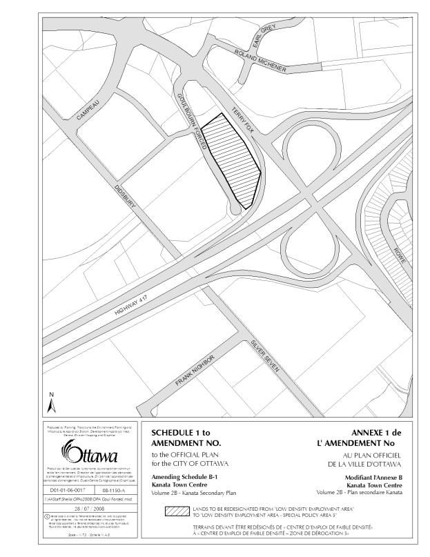
DETAILS OF RECOMMENDED ZONING DOCUMENT 5
Proposed
Changes to Comprehensive Zoning By-law 2008-250
1. The lands municipally known as 30 Goulbourn Forced Road as shown on Document 1 are rezoned from “IL7[307]-h” (Light Industrial Subzone 7, Exception 307, Holding) to “IL7[xxxx]-h” (Light Industrial Subzone 7, Exception xxxx, Holding).
2. A new exception zone, “IL7[xxxx]-h” will be added to Section 239 including the following site-specific provisions:
a) A retail store is permitted without any limitations on the types of products sold.
b) Clause 204(7)(d) does not apply.
c) Where a holding symbol is in place, the development of a retail store is prohibited until a transportation impact assessment has been submitted and approved that identifies the roadway/intersection modifications required to support the scale of development proposed.
d) The lot lines adjacent to Terry Fox Drive, Highway 417, Goulbourn Forced Road and Earl Grey Drive shall be deemed to be front lot lines.
e) Minimum front yard setback:
(i) 14 m from Highway 417 and Terry Fox Drive
(ii) 3 m from Earl Grey Drive
(iii) 0 m from Goulbourn Forced Road
f) A retaining wall is not permitted within the minimum front yard setback from Earl Grey Drive.
g) Clause 204(7)(k) does not apply.
h) On lands zoned “IL7[xxxx]”, the maximum aggregate gross floor area is 4,999 square metres for all retail store uses.
i) All of the lands within the “IL7[xxxx]” Zone are considered to be one lot for zoning purposes, notwithstanding the lawful division of a lot pursuant to the Planning Act, as amended, the Condominium Act, as amended, or any other similar legislation.
Proposed
Changes to the former City of Kanata Zoning By-law 142-93
1. The lands municipally known as 30 Goulbourn Forced Road as shown on Document 1 are rezoned from “M1C-1(H)” (Light Industrial, Mixed, Exception 1, Holding) to “M1C-x (H)” (Light Industrial, Mixed, Exception x, Holding).
2. A new exception zone, M1C-x, will be added to Subsection 6.1 including the following site-specific provisions:
a) The permitted uses are:
(i) All uses permitted in the “M1C” Zone;
(ii) Office Designing;
(iii) Furnish and Rental of Furnishings;
(iv) Recreational Establishment;
(v) Restaurant;
(vi) Restaurant, Fast Food;
(vii) Restaurant, Full Service;
(viii) Restaurant, Take-Out;
(ix) Automotive Mall;
(x) Automotive Parts and Accessories Store;
(xi) Automotive Sales/Rental Centre;
(xii) Automotive Service Centre;
(xiii) Uses lawfully in existence on the date of the enactment of this By-law are permitted uses;
(xiv) Planned Retail Centre;
(xv) Retail Warehouse;
(xvi) Retail Store;
(xvii) Warehouse.
b) Minimum front yard depth and exterior side yard width:
(i) 14 m from Highway 417 and Terry Fox Drive
(ii) 3 m from Earl Grey Drive
(iii) 0 m from Goulbourn Forced Road
c) A retaining wall is not permitted within the minimum front yard and/or exterior side yard setback from Earl Grey Drive.
d) The maximum gross floor area per development hectare for a planned retail centre and/or a retail warehouse in subsection 6.5(h) does not apply.
e) On lands zoned “M1C-x”, the maximum aggregate gross floor area is 4,999 square metres for all retail uses including, but not limited to Business Park Retail Outlet; Home Renovation Centre; Planned Retail Centre; Retail Store; and Retail Warehouse.
f) Despite the provisions of subclause 5.15(b)(i), part of any required front or exterior side yard may be used for the parking, storage, or loading of motor vehicles.
g) A landscaped buffer with a minimum width of 3 m shall be provided between a parking lot and all front lot lines and exterior side lot lines.
h) Minimum parking ratio of 3.4 spaces per 100 m2 of gross floor area will be required for a Planned Retail Centre, a Retail Store, and a Retail Warehouse.
i) Despite the provisions of subclause 5.15(c)(i), each parking space will be a minimum of 5.2 metres long except that parallel parking spaces will be a minimum of 6.5 metres long.
j) Despite the provisions of subclause 5.15(c)(ii), a private approach designed for two-way vehicular movement will have a minimum unobstructed width of 6.7 metres exclusive of any islands, or other such physical separation.
k) Where a holding symbol is in place, the development of a Retail Store and/or a Retail Warehouse are prohibited until a transportation impact assessment has been submitted and approved that identifies the roadway/intersection modifications required to support the scale of development proposed.
l) All of the lands within the “M1C-x” Zone are considered to be one lot for zoning purposes, notwithstanding the lawful division of a lot pursuant to the Planning Act, as amended, the Condominium Act, as amended, or any other similar legislation.
CONSULTATION DETAILS DOCUMENT 6
NOTIFICATION AND CONSULTATION PROCESS
Notification and public consultation was undertaken in accordance with the Public Notification and Public Consultation Policy approved by City Council for Zoning By-law amendments.
COMMUNITY ORGANIZATION COMMENTS
Comment: The following are the concerns of the Katimavik-Hazeldean Community Association (KHCA), at this time, as reviewed by Peter McNichol, President, concerning the OPA and Zoning amendment request for 30 Goulbourn Forced Road:
1. Fire Route for site is not indicated on drawing.
2. Handicapped parking for site is not indicated on drawing.
3. Bicycle Parking for site is not indicated on drawing.
4. Truck Route is not defined. Truck access, travel direction and truck departure route from site is required.
5. Right of way for future transit way must be maintained by city. Provisions as how to construct transit-way while maintaining store parking during and post construction must be considered.
6. Property must be structured to also minimize work and provide for the future extension of Earl Grey Drive to Goulbourn Forced Road under Terry Fox Drive.
7. Address or Street Name of Goulbourn Force Road should be changed to avoid confusion of emergency services with the other non contiguous portions of Goulbourn Forced Road.
8. Traffic Study must show traffic can be handled without affecting neighbouring commercial stores or residential community.
9. Site Plan must be submitted to address the above concerns which are not covered by the OPA and Zoning.
We would appreciate if attention could be brought to the above matters before the approval of the OPA and Zoning.
Response:
1.
The fire route
location will be addressed through the concurrent site plan application.
2.
The location and
number of handicapped parking spaces will be addressed through the concurrent
site plan application.
3.
The location and
number of bicycle parking spaces will be addressed through the concurrent site
plan application.
4.
The truck route
location will be addressed through the concurrent site plan application.
5.
The owner will be
required to convey the rapid transit corridor to the City prior to the registration
of the site plan agreement. The initial
development concept was to construct a parking area on the rapid transit
corridor lands. The development concept
has been revised to construct the retail store over the rapid transit
corridor. Therefore, parking will not
be affected during the construction of the rapid transit corridor.
6. The City already owns an unopened road allowance for the future extension of Earl Grey Drive between Terry Fox Drive and Goulbourn Forced Road.
7. The potential to change the Goulbourn Forced Road street name will be explored during the site plan approval process.
8. A revised Phase 1 transportation impact assessment is required to be submitted and approved prior to the lifting of the holding symbol and the approval of the Phase 1 site plan.
9. A site plan application has been submitted for the Phase 1 development.