Appendix 1 – Study Area (Map ‘A’)
1. Public Advisory Committee (PAC) Recommendations
§
Pro-active
Management
§
Development
Review Mechanism
§
Community
Characteristics Review Mechanism
2. Introduction, Background and Concepts
§
Origin
§
Study Area
§
Study Goals and
Objectives
§
Community
Development Planning Process Model and Concepts
3. Discussion of Study Findings
§
Policy and Zoning
Context
§
Neighbourhood
Conditions and Community Characteristics
§
Concerns and
Issues
4. Discussion of Recommendations (Solutions)
§
Pro-active
Management
§
Development
Review Mechanism
§
Community
Characteristics Review Mechanism
5. Public Consultation
6.
Appendices
That Planning and Environment Committee (PEC) recommend
that Council approve:
1.
That By-law Services and Public Works and Services
(PWS) be provided with necessary enforcement resources to proactively
enforce all infractions (i.e. not only ones initiated on a complaint basis); to
involve other City departments (as needed); and to revisit problematic
locations within the Queensway Terrace North (QTN) community.
2.
That, on a priority basis in the area called Pinewood
Crescent as described in both Appendices 1 and 10, By-law Services and Public
Works and Services be provided with necessary enforcement resources to specifically
and proactively enforce City By-laws regulating residential front yard parking;
soft landscaping requirements; parking on City rights-of-way; private
approaches or access to residential front yards.
3.
That Zoning By-law 1998 [By-law Number 93-98] be
amended to prohibit rear yard parking unless in a legally provided garage
located parallel to the side, with direct access from the public street to the
garage.
4.
That curbing be installed on streets where both
no curbing exists and there has been a problem identified defining a public
street edge where parking is appropriate.
5.
That trees be planted along the right-of-way streetscape
at the time of road reconstruction.
Plus, City Staff be directed to develop a tree-planting program, in
consultation with the Queensway Terrace North Community Association
(QTNCA), for areas identified as lacking streetscape and benefiting from the
presence of trees.
6.
That the Queensway Terrace North Community
Association undertake, with the co-operation of relevant City departments,
community-driven initiatives to bring awareness of City By-law regulations to
the residents and to property owners within its representative community area.
7.
That the Planning and Growth Management (PGM)
Department work together with the Queensway Terrace North Community Association
to ensure that new development proposals reflect the architectural, design and
planning compatibility guidelines as set out by the City of Ottawa’s
Residential Infill Housing Design Guidelines, and that the intent of good and
compatible planning, as set out in the Ontario Planning Act, is upheld.
8.
That Public Works and Services work together with the
Queensway Terrace North Community Association to ensure that when new works are
being considered within the area, traffic calming measures (e.g. speed humps,
stop signs) are given due consideration to reduce vehicular speeds and increase
safety.
9.
That those three-unit residential dwellings, as
detailed in Appendix 3, found to be non-conforming with existing Zoning By-law
standards, be made to conform to such regulations, or be made to revert back to
their original state.
10.
That while PAC supports intensification on Carling
Avenue, under the principle that access and egress be only from Carling Avenue,
the property at 807 Maplewood Avenue fails this principle, as traffic from this
site cannot access directly Carling Avenue and must traverse residential
streets in order to access Carling Avenue; therefore, Zoning By-law 1998
[By-law Number 93-98] be amended to reflect the R2C Zone of other properties
having similar access and egress situations as those at the north end of
Maplewood Avenue.
Development Review Mechanism
11.
That a Development Review mechanism be established to
trigger a review of various key community indicators as a means to ensure that
City of Ottawa intensification policies do not facilitate development that
negatively impacts the affected neighbourhood.
a.
That the Development Review mechanism be triggered at
120 % of the existing development under the present zoning, based on the number
of legal dwelling units within four-block areas (see 11b. below), as of January
1, 2007.
b.
That the Development Review be effective over the
Queensway Terrace North area and comprised of four (4) quadrants, in total
comprising 10 zones, where each zone consists of an average of four (4) blocks,
as exemplified in Appendix 8.
c.
That the
Development Review trigger mechanism be monitored by the Planning and Growth
Management Department, in cooperation with the Queensway Terrace North Community
Association, as of January 2007. That
the PGM provide data statistics (including location, land use, number of units)
to the QTNCA based on approved Building Permits. That the QTNCA map the levels of development according to the
designated zones and once the 120% of existing development has been reached
will, with the cooperation of PGM, initiate the Development Review of community
indicators.
d.
That the Development Review be conducted over the
affected triggered zone, and include a cooperative assessment by City staff and
the Queensway Terrace North Community Association of:
i.
Infrastructure condition and capacity, including key indicators such water supply; waste water collection;
storm water drainage; traffic; and transit.
ii.
Community characteristics (as detailed in Appendix 7)
iii.
Zoning By-law, as
a reflection of the needs of the community and the City at large.
12.
That the Zoning for Pinewood Crescent be amended to
permit existing densities only, and that no secondary dwelling units and/or
minor variances shall be permitted until the Pro-active By-law Management has
solved the existing problems and a further Development Review of this street
has been undertaken to determine whether such a 'freeze' can be lifted at that
time.
13. That a
Community Characteristics Review mechanism be established to trigger the
Development Review of various key community indicators as a means to ensure
that City of Ottawa intensification policies do not facilitate development that
negatively impacts the affected neighbourhood.
14. That when,
in the opinion of the Queensway Terrace North Community Association, there is
an actual and/or the possibility of a negative, community-wide change in the
community’s characteristics caused by implemented or proposed development, the
QTNCA undertake a survey of community residents’ opinion of community
characteristics (as detailed in Appendix 7) and that City staff provides
professional advice in the design of a formal and scientific-based survey.
15. That the
QTNCA, using the above-completed survey, make an application to the City’s
Planning and Environment Committee for a Development Review.
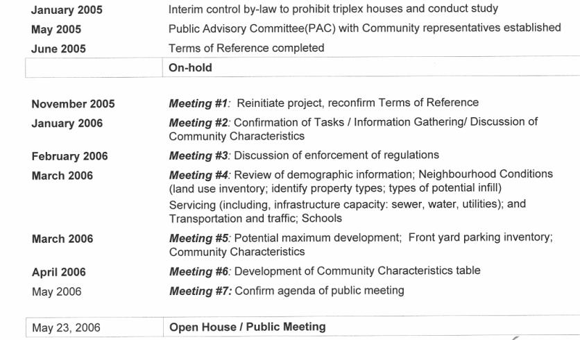
An Interim Control By-law was
enacted on January 12, 2005 in response to increasing community concern over
the number of residential triplex conversions within the Queensway Terrace
North community (QTN) that were not in compliance with the Zoning By-law 1998,
and the long-term impacts of such incremental intensification within this
neighbourhood. The By-law prohibits the
conversion of duplexes to triplexes within the defined area until a Study on
the appropriate limits to intensification in the Queensway Terrace North
Community is completed, with an expiration of January 11, 2007.
The City of Ottawa Official Plan
promotes intensification as an alternative to urban sprawl and proposes that
intensification occur as a gradual change to existing communities so that the
fundamental characteristics of existing communities are not altered. However, there is concern within QTN that
there are no policies within the new City of Ottawa Official Plan setting
limits as to when intensification is too much.
Since there are number of illegal triplexes within QTN, the community is
concerned about the inability of the new Official Plan to protect the QTN, and
other communities within the City, from excessive and/or negative
intensification.
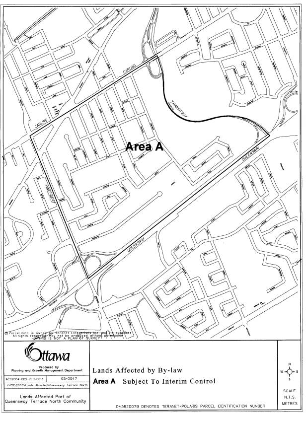
The Study Area boundaries are: Carling Avenue to the north;
the Transitway to the east; the Queensway to the south, and Pinecrest Road to
the west (Appendix 1). The Study Area is characterised by predominantly
low-density residential streets, with recreational open space uses at its core,
and two school properties. There are three major areas of natural features and
open spaces within the Study Area. The presence of the OC Transpo Transitway
along the Pinecrest Creek Corridor at the eastern boundary affords an extensive
landscaped edge to the neighbourhood. The arterial roadways of Carling Avenue
and Pinecrest Road abut the Study Area, and provide access to the City’s upper
tier road network and transit systems.
An industrial and commercial zone occupies the southwestern portion of
the Study Area, adjacent to the Queensway.
The Queensway Terrace North
Community Association encompasses the Study Area within its area of interest,
and provides the primary vehicle for community involvement.
The goal of this Study is to
conduct a review of the likely forms, locations and appropriate levels of
intensification within the Queensway Terrace North community, the ability of
existing infrastructure to accommodate growth, and the potential impact of
evolving City Council intensification policies on this neighbourhood. City
staff has undertaken this Study, in conjunction with the Queensway Terrace
North Community Association, community residents and property owners, and the
Ward Councillor. The final report will
serve as a guide for future growth within this neighbourhood.
The objectives of the Study, aimed
at achieving the above goal, are as follows:
·
Ensure that the Study is undertaken with direct involvement
of local residents, and that the outcomes support residents’ vision for their
community.
·
Conduct an issue-based review of existing conditions within
the Study Area.
·
Interpret project relevant, citywide policy direction within
a local context.
·
Analyse existing transportation, service and infrastructure
capacities.
·
Identify notable community characteristics that will likely
be affected by intensification.
·
Quantify intensification potential within the Study Area.
·
Identify infill, and property conversion design issues.
·
Determine appropriate limits to intensification within the
Study Area.
·
Establish a ‘community development planning process’ model
through which and by which intensification actions can be measured and managed.
Community Development Planning Process Model and Concepts
From
the outset of this Study, the QTN Public Advisory Committee (PAC) was troubled
by the lack of a common Community Development Planning Process model that could
be followed by City Communities and indeed even the lack of a proper definition
of what could be a called a ‘community’ as it truly impacts affected residents. The QTN PAC therefore proposes three
intensification planning process model concepts and two definitional parameters
through which this QTN PAC Study should be read:
1. Community Development Planning Process Model
In examining other Community Development Planning exercises
undertaken by the City, the QTN PAC was struck as to how each was a unique
exercise. Some were conducted in a top
down approach, driven by the City Planners with or without outside consultant
input. Many of these identified infill
possibilities and even went so far as to propose specific building types and
density. Many of these also sought
public input but without fully articulating the overall impact on traffic,
parks, water and other common utilities.
Other Community Development Planning processes obviously had significant
developer input and influence. Still
others sought true public input and tried to reflect that input into the draft
plans. Although many, if not all, of
these Community Development Planning processes appeared to have similar
objectives (i.e. how to accommodate greater density and intensification), these
Community Development Planning processes did not seem to allay community fears
that their input was being taken seriously nor were there mechanisms in place
to determine when the ‘intensification too far’ line was crossed. As the late Jane Jacobs stated: “Communities
are organisms which have a life of their own and will evolve and/or devolve
according to their own rules and regiments”.
That being said and with the recommended development freeze in the
Pinewood Crescent area excepted, the QTN PAC has taken the position that it
cannot presumptuously determine where new and additional development should or
should not occur. Rather it has
concentrated its efforts in trying to develop a Community Development Planning
Process Model that can give community residents confidence that they will have
some control over how development proceeds in their neighbourhood and that the
Development Review Mechanism Trigger Points will be in place to provide that
level of comfort.
2.
Community
Characteristics as a Top Priority Defining Aspect
People settle in communities for a variety of oft-times
subjective reasons. However, once
settled, they grow an attachment to their area and start to define it in
complimentary terms. These are, in the
QTN PAC’s opinion, what are called Community Characteristics and are the
aspects that residents want to protect and preserve as their top priority going
forward. As communities grow and evolve
and as residents come and go, these community characteristics will undoubtedly
evolve and change. These changes are
usually slow and gradual and are accommodated or accepted overtime by
residents. However, when change is
rapid and/or when change negatively disrupts what residents view as their
community’s core characteristics, this is the time that community unrest and
upheaval emerges. The QTN PAC therefore
considers the definition of Community Characteristics as a key priority to
Community Development Planning Processes against which all intensification is
measured and proactively managed (see Point #3 below).
3.
Proactive
Management and By-law Enforcement
MOST community residents are law-abiding citizens. As in any community, there is, however, a
small minority who knowingly or unknowingly flout these laws. When this occurs, it is the QTN PAC’s
opinion that remedial enforcement action should be immediately and proactively
applied. To not to do so creates
resentment among law-abiding citizens towards the citizens (neighbours)
breaking the law and getting away with it, potentially leading to an attitude
of “if they can do it, so can I”. The
existing system whereby City By-laws are enforced through a neighbourhood complaint
(snitch line) system is problematic and flawed in that it relies on neighbour
complaining against neighbour - something that most people are naturally
reluctant to do until the problem becomes too big or too offensive. By the time such ‘major issue’ enforcement
is in fact applied, the majority of residents are disillusioned and upset with
city officials and elected representatives.
The QTN PAC is therefore strongly of the opinion that residents would be
much more willing to accept and to welcome change if they could also be
convinced that ALL residents played by the same rules and that these rules were
being effectively, proactively and fairly enforced by City By-law officers and
law enforcement officers who could reasonably have known about the infractions
without a complaint having been first filed.
4.
The Closer
Development Gets to One’s Home, the Greater the Concern:
The QTN PAC fully understands the larger concept of what a
community entails (e.g. neighbours, facilities, events, respect). However when change occurs, a resident’s
main concern is how will this affect my family, my immediate neighbours and
me. An architecturally incompatibly
constructed building in Orleans will have very little effect on a person living
in Kanata but the closer such unacceptable development gets to one’s own block,
the higher the concern and defensive reaction.
Acknowledging that City communities are usually large in scale and that
these communities are oft-times made up of several different sectors and
diverse areas but giving credence to “the closer it gets, the more concerned I
get” feelings of residents, the QTN PAC proposes the acceptance of Development
Review Triggers based on the smaller (block) community concept. The QTN PAC
originally brainstormed that such Development Triggers be for each individual
block but, realising the high resource impact of such a proposal, it opted for
a four-block concept within a community zone quadrant. By going this route, the QTN PAC is trying
to respect the nearness of one’s ‘true’ community and how the effect that
development has on it, while, at the same time, respecting the cost to the City
in undertaking such Development Reviews.
5.
The
Slowness of Development
It has taken Queensway Terrance North (and Britannia
Heights encompassed therein) over 100 years to develop into the community that
it is today. However given that future
development will most probably occur at a somewhat quicker pace than years gone
by, it will nevertheless not occur at lightening speed either. The QTN PAC therefore wants to stress that
the need (and hence the cost) for triggered Development Reviews should
consequently be viewed in a slower development scenario context.
The Public Advisory Committee recognizes that there are many policy and legal frameworks within which planning decisions must be made. Moreover, PAC understands and agrees with the premise of intensification as an important and necessary strategy for the future sustainability and well-being of Ottawa.
The Provincial Government provides policy direction on matters related to land use planning and development. In its policy statement on housing the Province identifies the need for municipalities to meet the projected housing needs of current and future residents through a combination of new development and all forms of residential intensification to all income levels.
The Council-approved City of
Ottawa Official Plan (2003) designates the residential portions, and subject
portions, of the QTN Study Area as “General Urban” land use
classification. A “Mainstreet”
designation is applied to Carling Avenue forming the northern boundary of the
Study Area. The Official Plan policies
and parameters support residential intensification within the urban boundary as
an alternative option to continued green field development. Such policy direction indicates that areas
primarily promoted for major intensification generally lie outside of existing
residential neighbourhoods, in mixed use centres, developing communities and
along existing mainstreets; however, minor residential intensification
opportunities do exist within existing residential areas.
In order to implement the new Official Plan, the City considers opportunities to provide minor residential intensification within existing neighbourhoods through some development of vacant or underdeveloped sites, and also through secondary dwelling units (single self-contained, rental apartment that is a separate residential unit subsidiary to, and located in the same building as, its principal dwelling unit) in all single, semi-detached and duplex dwellings. The Secondary Dwelling Unit By-law passed in September 2005 captures many existing triplex units as secondary dwelling units. If they are in conformity with building and zoning regulations, then these units which were previously non-conforming with zoning regulations, will be recognized as being legal residential units.
In the Official Plan, “Section 2.5.1 Compatibility of Development” states that introducing new development in existing areas that have developed over a long period of time requires a sensitive approach to differences between the new development and the established area, in terms of building heights, setbacks, and other characteristics. PAC wants to implement appropriate mechanisms to ensure that new development, whether new buildings or secondary dwelling units, are compatible with the neighbourhood and that maintain or enhance the existing quality of life.
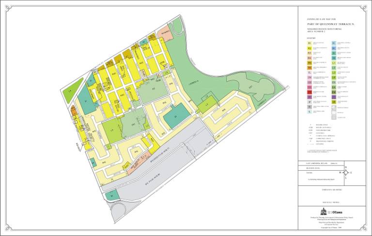
The study area contains a
relatively broad range of different land use zones, including a variety of
uses; Residential; Institutional (e.g. two schools; two churches ); Industrial
(e.g. southwestern portion of QTN abutting the Queensway); Environmental (e.g.
three green spaces, including the Transitway lands); and Leisure (e.g. four
recreational open spaces).
The Residential zones are
predominantly characterised by R1G zone (detached houses; with minimum lot
areas of 464 m² and minimum lot widths of 15m) and R2C zone (detached and
duplex houses, with minimum lot areas of 464 m² and minimum lot widths of 15m;
and semi-detached houses, with minimum lot areas of 232 m² and minimum lot
widths of 7.5m). Generally, the R1G zone spans the
southeastern half of the study area, while the R2C zone covers most of the
northern half. While the concerns of
this study were precipitated by and are mainly focused on the effects of
intensification in the R2C zone (Appendix
2), the QTN PAC Recommendations apply to the whole of the Study Area.
There are also pockets of R3 Zones
(Converted Houses/Townhouses); R4 Zones (Multiple Unit Zones) on Carling Avenue
and Moncton Road; R5 Zone (Low Rise
Apartments) on Carling Avenue; and R6 Zone (Highrise apartments) at Pinecrest
and Richmond Roads.
PAC understands the current
policies and zoning framework for the scope of the Study. Moreover, PAC agrees that intensification is
an important strategy for the long term sustainability of the City of Ottawa
and its various neighbourhoods. As one
QTN PAC member stated “Making efficient and effective use of what we have is a
good thing. We cannot sprawl forever
given the costs that implies to the well-being of our economy and our physical
health”.
However, PAC remains unconvinced
that, under existing policy and zoning, the potential negative impacts of
intensification upon existing neighbourhoods will be identified and/or well
managed in advance of their occurrence.
Therefore, PAC seeks to establish a framework that can heed such warnings
as they present themselves.
Public
Advisory Committee members and City staff undertook a review of current
Queensway Terrace North community conditions, focused primarily on demographics
and on characteristics.
In
general, QTN demographics reflected trends witnessed Citywide. With a 2001 Census population of 3258, the
QTN population grew by about 15% since 1996 reflecting a increased rate in
population growth compared to that of the City of Ottawa’s 6.5% rate of
population growth over the same time period.
While approximately 20% of the population is under 19 years of age,
approximately 30% of population is over 55 years old and reflects an aging
resident make-up. The QTN has a much
higher proportion of seniors (aged 65 and over) and widowers than the City,
indeed the QTN has the second highest proportion of seniors in Canada, with
Victoria having the highest. It also
has a higher percentage of children over 25 still living at home and has a much
higher percentage of homeowners than the City as a whole.
Immigrant
population has continued to decline, but the neighbourhood continues to be
ethnically diverse. There are two
public elementary schools that continue to operate. There has been much deliberation over the future of Grant Alternative
School; however, it will remain operational in the neighbourhood for the near
future.
PAC members developed a list of
community characteristics that they felt defined the QTN community identity (Appendix
7). These were presented and
accepted at a subsequent QTN PAC-led, public consultation Open House. In this list, PAC also identified community
characteristics that were threatened, and how they were threatened, as a result
of triplex conversions, or secondary dwelling units, and potentially, other
forms of small-scale intensification.
The following 12 community
characteristics were identified as the essential and representative elements
defining the QTN neighbourhood:
·
Good
pedestrian / cycling / rollerblading environment
·
Diverse
demographics
·
Sense
of pride in community and identity
·
Clean
neighbourhood
·
Safe
neighbourhood
·
Location
convenience
·
Adequate
(albeit low) water capacity
·
Diversity
in housing
·
Very
green, natural environment
·
Quiet
neighbourhood
·
High
quality of life
·
Stable
property values
The
fundamental community concern of PAC is the effect of incremental
intensification on the community characteristics of the Queensway Terrace North
neighbourhood. The incremental
development of three-unit dwellings and their negative impacts exemplify this
concern. In some areas of the QTN
community, these three-unit dwellings (also known as triplexes) create
unacceptable behavioural and physical impacts.
The following is a list of the impacts identified that currently erodes or
could potentially erode the defining and desirable characteristics of the
community noted earlier:
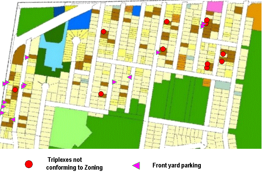
·
Illegal
parking on front yards of private property and on City boulevards (Refer to
photos in Appendix 9):
While Pinewood Crescent is the
ultimate example of front yard parking gone amuck (see Appendix 9), there are
other locations in the QTN that are also experiencing this illegal and
inappropriate behaviour. Parking on
front lawns and paving over green space contributes to an unruly look, which,
in turn, oft-times leads to unruly and unacceptable behaviour.
·
Lack
of architectural compatibility:
Examples of this have cropped up all
over the City where buildings, uncharacteristic to the neighbourhood, have been
erected thereby creating a noticeable change to the existing streetscape.
Complaints and concerns about incompatible design from residents to City Staff
and to developers have not (for the most part) been addressed satisfactorily.
This leads to residents feeling that their opinions are not being seriously
considered and/or indeed are even being ignored. Oft-times the residents feel that they are fighting both the
forces of the developers and the City officials combined.
·
Deteriorating
streetscape (i.e. more cars, less green space):
Please refer to the front yard
parking concern expressed above.
·
Greater
traffic volumes and speeds:
As the arterials (Carling and
Pinecrest) become increasingly congested, more and more traffic is appearing on
the QTN streets as these structures act as relief valves. Many drivers do not come from the QTN and
thus have less regard and loyalty to the community as a whole. Speed and squealing tires at all times of
the day and night have increased steadily over the years. Since many of the QTN streets lack sidewalks
(a desired community feature by the way), this combination of more and faster
cars with that of street pedestrian traffic may start to pose a safety
problem. The classic answer to such
problems is to separate the people and the cars by constructing sidewalks. The QTN PAC however suggests that reducing
the vehicular traffic and the speed with which it travels – thus preserving the
community instead of protecting the inconsiderate drivers – is the more
community-friendly way to go.
·
Low
water pressure:
Although deemed adequate by the
City, currently there are five ‘red, low water pressure’ zones in Ottawa,
which, by today’s standards, most citizens would find to be sub par. The QTN is one of them. Increased density in the QTN would therefore
negatively impact an already affected, low water pressure area and potentially
would require the City to rectify the situation in advance of implementing its
capital expenditure plan.
·
Increased
noise:
As more people and traffic traverse
the QTN, the disrupting vehicular noise level is also increasing to say nothing
of ghetto blasters, skateboards and louder partying late into the nights.
Given
the presence of some of the above, PAC feels it reasonable to assume a further
increase in the community’s population will magnify the number of incidents of
these problems. To better understand
the appropriate limits for intensification for the QTN community, City staff
and PAC wished to quantify the intensification potential of the Study
Area.
Different
development scenarios were devised, each one estimating future population,
number of units, and the number of cars.
These development estimate scenarios were drawn up to show the effects
on the basic infrastructure as well (including water supply, wastewater
collection, stormwater drainage, and traffic capacity). The development scenarios include the
following (see Appendix 11 for further detail):
|
|
Today’s
development |
Maximum
development1, under the existing zoning |
Maximum
development1 under the existing zoning, plus secondary dwelling
units |
Estimated
development by year 2021 |
“Limited
development”, 120% of today’s existing development |
|||||
|
Total
Number of Units |
1211 |
1599 |
2703 |
1573 |
1473 |
|||||
|
Total
Estimated Population |
3258 |
4301 |
7271 |
4231 |
3909 |
|||||
|
Total
Estimated Cars |
1453 |
1919 |
3244 |
1888 |
1744 |
|||||
|
Average number of Occupants per Unit (City of
Ottawa) |
2.69 |
|
|
|
|
|||||
|
Average number of Cars per Unit (City of Ottawa)
|
1.2 |
|
|
|
|
|||||
The
main conclusions demonstrated that under existing zoning by including secondary
dwelling units, the population, number of dwelling units and cars in the study
area could more than double from the existing levels. City staff estimates
indicate that basic infrastructure needs can generally be satisfied; however,
each aspect of infrastructure would need to be monitored as development
applications are received and as periodic upgrades would likely be
required. Under the maximum “worst case
scenario”[1],
the infrastructure capacities would certainly need re-evaluation, with likely
extensive upgrades being needed.
The
most important conclusions by PAC in the review of concerns and issues are that
(1) the management of intensification to date in areas of the neighbourhood is
not satisfactory and that (2) if intensification of the neighbourhood is
intended to continue into both the medium and long-term, better methods of
addressing it are necessary.
4. Discussion of
Recommendations (Solutions)
Over
the course of the study it became evident that in trying to better understand how
intensification should be approached in the future, two themes must be
explored. First, the City should adopt
an approach that does not allow existing healthy and satisfied communities to
reach a point where they find themselves negatively impacted, such as in the
Queensway Terrace North. The City must
protect its communities, including reinstating them where defined community
characteristics have been lost or are in jeopardy. Second, the approach should both maintain and enhance identified
characteristics that define the community.
With this in mind, the Public Advisory Committee devised a two-pronged
approach to intensification to ensure those objectives would be achieved: (1) Proactive Management, and (2)
Development Review Mechanism. The
following recommendations are based on these principles.
Proactive Management means ensuring the
enforcement of those regulations the City has carefully developed over many
years to protect its citizens and to maintain a high quality living
environment, before such time that violations become repetitive and a chronic
malaise sets in. There were a number of
issues that PAC felt needed to be addressed in Queensway Terrace North before
the above could be achieved.
Therefore, PAC recommends the
following:
1.
That By-law Services and Public Works and Services
(PWS) be provided with necessary enforcement resources to proactively
enforce all infractions (i.e. not only ones initiated on a complaint basis); to
involve other City departments (as needed); and to revisit problematic
locations within the Queensway Terrace North community.
PAC
observed a number of recurring circumstances regarding by-law violations in the
QTN community:
·
Some residents are acting inappropriately and breaking
by-laws on a repeated basis without consequences. Some offenders may actually believe they are not offending
because they have never been charged, and may “normalize” the offence by
repeating it daily or even altering their environment to facilitate it. (See attached photos. Appendix 9.) Some of these violations include front
yard parking, illegal triplexes, speeding and noise.
·
By-law enforcement is under-resourced (i.e. 16 officers to
cover 24 hours and 64,000 complaints across the entire City).
·
By-law enforcement is a reactive system. That is, a
complaint is needed in order for By-law Enforcement staff to respond. Moreover, the complaint may take many months
to resolve.
·
Neighbours normally do not like to complain about the
neighbours behaving objectionably, as they need to coexist with these persons
after a complaint has been made
Considering
the above observations, PAC feels the present levels of enforcement cannot
uphold the laws of the City and, therefore, adequately protect the QTN
community as those laws were intended.
PAC strongly feels the only way to achieve this is through enforcement
that is proactive and that addresses violations in a timely manner, before they
“snowball” and the essence of a neighbourhood is lost. QTN PAC further recommends that By-law
Services be given appropriate resources and the mandate to enforce the City’s
By-laws proactively.
2.
That, on a priority basis in the area called Pinewood
Crescent as described on both Map “A” (Appendix 1) and as highlighted in
Appendix 10, By-law Services and Public Works and Services be provided with
necessary enforcement resources to specifically and proactively enforce City
By-laws regulating residential front yard parking; soft landscaping
requirements; parking on City rights-of-way; private approaches or access to
residential front yards.
PAC has identified Pinewood
Crescent (Appendix 10) as a neighbourhood within the QTN community that has lost its character
and quality of life due to the lack of resources and, therefore,
under-enforcement of City By-laws, as discussed in Recommendation No.1. The most recurring By-law violation impacting this street is illegal parking
on front yards of private property and on City boulevards (Refer to photos in Appendix 9). Illegal parking of this nature and the lack of enforcement is so
much the norm that property owners have paved asphalt around fire hydrants (to
better accommodate parking), paved parking spaces on City-owned boulevards, and
laid interlocking brick or paved asphalt over most of the front lawns, or simply parked vehicles
on the grass on front lawns to accommodate parking. In most cases, there are sufficient onsite, front yard, parking
spaces (as required by the zoning by-law), but as a matter of convenience the
above illegal actions now characterize this QTN neighbourhood street.
3.
That Zoning By-law 1998 [By-law Number 93-98] be
amended to prohibit rear yard parking unless in a legally provided garage
located parallel to the side, with direct access from the pubic street to the
garage.
PAC is concerned
that rear yard parking would become the preferred alternative to illegal front
yard parking should the latter be enforced.
This would deteriorate the tranquil backyard environment of neighbours
(e.g. increased noise and exhaust) and would decrease the amount of green space
and area for natural stormwater drainage.
Therefore this limitation to protect backyards for residential amenity
use is being proposed.
4.
That curbing be installed on streets where both
no curbing exists and there has been a problem identified defining a public
street edge where parking is appropriate.
Parking in
some parts of the QTN community, notably but not exclusively to Pinewood
Crescent, occurs in an exceptionally haphazard manner on city streets and
boulevards. PAC believes that part of
the reason parking occurs in such a disorderly manner is that it is so easy
without curbs for vehicle owners to locate their vehicles anywhere. Block curbs would both help to obstruct
access to potential illegal parking spaces and also to frame the parking, e.g.
in lines along the street edge, in more orderly arrangement (that actually
buffers homes from the streets). This
illegal parking, especially on the street itself, also poses a safety risk for
children darting between an array of haphazardly parked vehicles.
5.
That trees be planted along the right-of-way streetscape
at time of road reconstruction. Plus, City Staff be directed to develop a
tree-planting program, in consultation with the Queensway
Terrace North Community Association (QTNCA), for areas identified as lacking
streetscape and benefiting from the presence of trees.
As noted previously in Recommendations No.3 and 4, parking in some parts
of the QTN community, notably but not exclusively to Pinewood Crescent, occurs
in an exceptionally
haphazard manner on private front yards, city streets and boulevards. Not only does this create a disorderly
streetscape dominated by vehicles, but it deters from the planting of trees
which would both improve the streetscape by naturalizing it, but would also disable
future potential for illegal front yard or boulevard parking as the tree would
also act as an obstacle to such behaviour, and encourage parking in the
intended parking locations.
6.
That the Queensway Terrace North Community Association
undertake, with the co-operation of relevant City departments, community-driven
initiatives to bring awareness of City By-law regulations to the residents and
property owners within its representative community area.
PAC believes that while some by-law offenders are conscious of their illegal behaviour and actions, other existing offenders or property owners may be only at the stage of thinking of behaving or physically altering their property in way that does not comply with current City by-laws, perhaps, because they see others doing it, and/or they are unaware that such action is prohibited. PAC believes that the QTNCA could assist in the education of its residents regarding key City by-laws or initiatives of which they should be aware. Further to the enforcement efforts of the City, PAC believes QTN property owners must also be responsible for ensuring where they live remains a high quality living environment. Education efforts could take the form of awareness flyers, QTNCA seminar sessions, booths at community events and so forth.
7.
That the Planning and Growth Management (PGM)
Department work together with the Queensway Terrace North Community Association
to ensure that new development proposals reflect the architectural, design and
planning compatibility guidelines as set out by the City of Ottawa’s
Residential Infill Housing Design Guidelines, and that the intent of good and
compatible planning, as set out in the Ontario Planning Act, is upheld.
PAC is
concerned that developers are being allowed to build architecturally
incompatible housing. Given the
relatively large lot sizes found through QTN community, there is potential that
property owners wishing to redevelop will seek to maximize building size and
height that are not in keeping with the scale or character of residential
development found within QTN. Of
particular concern, are compatibility of heights, rooflines and setbacks (from
street, side and rear yards) with neighbouring buildings.
PAC is
aware that in addition to development parameters described in the Official Plan
and requirements of the Zoning By-law, the City also has approved the
Residential Infill Housing Design Guidelines to provide design direction for
infill development. These assist both
those proposing change and those evaluating the proposals; they provide clarity
on the City’s expectations for intensification proposals of an infill
nature. PAC strongly recommends that
both developers proposing new construction and City planners and other City
staff reviewing development applications pay particular attention to such
guidelines to ensure the architectural character and heritage of the QTN
community is maintained. Given that
most residents are not against development per se but are against incompatible
development, enforcing this recommendation will go a long way to removing a
constant and continuing irritant between residents, developers and the City.
8.
That Public Works and Services work together with the
Queensway Terrace North Community Association to ensure that when new works are
being considered within the area, traffic calming measures (e.g. speed humps,
stop signs) are given due consideration to reduce vehicular speeds and increase
safety.
PAC is concerned that given
the width or capacity of some of the QTN neighbourhood streets that vehicular speeds need to be
reduced to ensure the safety of the pedestrian environment and the residential
character of the community.
9.
That those three-unit residential dwellings, as
detailed in Appendix 3, found to be non-conforming with existing Zoning By-law
standards be made to conform to such regulations or be made to revert back to
their original state.
While PAC accepts that
secondary dwelling units are a legitimate means for the City to meet its
intensification goals, PAC cannot accept that any such units that do not conform to the standards
described by the Secondary Dwelling Unit By-law be permitted. Such units having characteristics that
either degrade the neighbourhood character; that disrupt how the neighbourhood
functions (e.g. front
yard parking) or that pose internal building safety concerns should not be
permitted. Secondary Dwelling Units are
acceptable only if they meet all City regulations.
10.
That while PAC supports intensification on Carling
Avenue, under the principle that access and egress be only to and from Carling
Avenue, the property at 807 Maplewood Avenue fails this principle, as traffic
from this site cannot access directly Carling Avenue and must traverse
residential streets in order to access Carling Avenue; therefore Zoning By-law
1998 [By-law Number 93-98] be amended to reflect the R2C Zone of other
properties having similar access and egress situations as those at the north
end of Maplewood Avenue.
PAC maintains its support for intensification, especially along areas where it can maximize
public infrastructure, such as transit on Main Streets; however, it must be
done appropriately and cannot be done in a “one size fits all” manner. In particular, there are serious concerns
regarding the intensification
of property on streets that are blocked off from the main arterial, Carling
Avenue. Properties abutting Carling
Avenue, but with other frontage onto local, neighbourhood streets, were zoned
with a higher R5A H (10.5) zone on the basis that the activity they generate would be directed towards the
streets designed with higher infrastructure better suited to absorb that higher
density and vehicular traffic.
PAC is concerned about maintaining the existing R5A H (10.5) zone on
three main accounts:
·
When these streets are
blocked off (i.e. no other exit, such as Maplewood Avenue at Carling) all
traffic has to go back and forth on the same block to get in and out;
·
There is concern about where
parking will go in such cases, especially, visitor parking. A blocked off street has less finite
transiting capacity than most other streets.
·
When blocked off, fire
engines, garbage trucks and other large emergency and utility vehicles have to
carefully manoeuvre to turn around.
Given concerns that on-street, visitor parking will likely occupy the
ends of such blocked streets, safety, operations and functionality may be
jeopardized in such a "congested" environment
Development Review Mechanism
11.
That a Development Review mechanism be established to
trigger a review of various key community indicators as a means to ensure that
City of Ottawa intensification policies do not facilitate development that
negatively impacts the affected neighbourhood.
a.
That the Development Review mechanism be triggered at
120% of the existing development under the present zoning, based on the number
of legal dwelling units within four-block areas (see 11b. below), as of January
1, 2007.
PAC sees no evidence of and thus remains unconvinced that existing City
policy and zoning can
detect warnings that development in a community is reaching a point where the
desirable, defining community characteristics are about to be negatively
impacted, and that consequently the community will change for the worse; that
is, there is currently
no way of setting limits to determine where intensification is too much. Therefore, PAC proposes to establish a
framework that can monitor the impacts – and most importantly the negative
impacts - of intensification in advance of their occurrence, or at least as soon as possible
after they have occurred. Thus, if a
community is being harmed it does not become irreparably harmed and any damage
done can yet be repaired.
The recommended mechanism proposes to track any new
development of residential units on a four-block basis (see Appendix 8). Once 120% of the existing level of
residential development, as of January 1, 2007, is reached or exceeded, a
development review is initiated to determine the ‘state of the Development
Review Zone/Quadrant’, thus highlighting whether intensification is occurring
in a manner that addresses and reflects community characteristics, and is
therefore, compatible with affected neighbourhood(s).
b.
That the Development Review be effective over the
Queensway Terrace North area and comprised of four (4) quadrants, in total
comprising 10 zones, where each zone consists of an average of four (4) blocks,
as exemplified in Appendix 8.
PAC recognizes that for the review to be effective and manageable the
review area cannot be too large or too small. If the
area is too large, e.g. a level of 120% is reached over the entire QTNCA area,
then the review may not capture certain areas where a notable trend is emerging
until it is too late. A non-responsive
mechanism defeats the purpose of triggering the development review in a timely manner. Conversely, if the area is too small, e.g. a
level of 120% is reached when only two residential units are developed or
installed (in the case of secondary dwelling units) within an existing 10 home area, the mechanism may
be over reactive, and trigger an unnecessary review which would be too
burdensome for City staff and resources and would likely be premature to draw
conclusions. As illustrated in Appendix
8, the area of the blocks to be monitored would be from the rear yard property lines of one
block and extend across to the rear yard property lines on the adjacent block,
so that blocks consist of the houses that face each other across, rather than
the traditional four-sided block (i.e. properties bounded by the same four streets). Though most neighbourhood blocks will follow
this configuration, there may be some anomalies that would need to be
delineated in a different way.
The QTN PAC recognizes and understands the logic behind the City’s stated objective of a higher
density along Main Streets and Arterials (i.e. for the better use of public
transit). It further recognizes that
its recommended 120% Development Review Trigger might be activated more frequently
along those zones and quadrants bordering these streets. It
thus, in its deliberations, considered raising the Development Review Trigger
percentage (i.e. the 120%) to a higher level for the ‘block’ zones along those
particular roadways (i.e. zones 9 and 10) in order to reduce the frequencies of Development
Reviews for these two areas. However,
the QTN PAC was also cognizant of the need to treat all QTNCA residents equally
and therefore, given this dilemma, has opted to stay with the 120% Development
Review Trigger for all zones and quadrants within the QTN for the time being until an acceptable, equitable and alternative Development Review
Trigger process can be found for community ‘block’ zones along main streets and
arterials.
c.
That the
Development Review trigger mechanism be monitored by the Planning and Growth
Management Department, in cooperation with the Queensway Terrace North
Community Association, as of January 2007.
That the PGM provide data statistics (including location, land use, number
of units) to the QTNCA based on approved Building Permits. That the QTNCA map the levels of development
according to the designated zones and once the 120% of existing development has
been reached will, with the cooperation of PGM, initiate the Development Review
of community indicators.
PAC
recognizes that care and responsiveness to a city community is the
responsibility of both the City of Ottawa and residents of the community. As the City of Ottawa is recipient,
processor and record-holder of building permit approvals, and other development
applications, it is in the best position to track the level of development
activity within the QTNCA area.
However, given that community well-being is a priority for the QTNCA it
is also important that it assist the City in monitoring and reviewing this
information once it is received from the City.
Having both the City and QTNCA receive regular information provides a
double-check on the level of activity within the community, and therefore, will
ensure that the development review mechanism is triggered when it ought to be.
d.
That the Development Review be conducted over the
affected triggered zone, and include a cooperative assessment by City staff and
the Queensway Terrace North Community Association of:
i.
Infrastructure condition and capacity, including key indicators such water supply; waste water collection;
storm water drainage; traffic; and transit.
ii.
Community characteristics (as detailed in Appendix 7)
iii.
Zoning
By-law, as a reflection of the needs of the community and the City at large.
The Development
Review is designed to assess whether current intensification activity is
appropriate and if it is anticipated to remain so in the short to mid-term for
the quadrant where the affected zone is located. The Development Review would be a study initiated by City staff once 120% of the baseline,
existing development in that affected area had been reached. Aspects of the review would be conducted
closely with the QTNCA. Public
consultation would be focussed on the residents of the affected area.
City staff
would assess key infrastructure conditions and capacities to establish at a
basic, hard services level if further development is suitable. An assessment of whether QTNCA community
characteristics were being satisfied would be conducted (See Recommendation
No.13). Depending on the results, a
Zoning By-law review would be conducted to assess the relevance of current
policies and requirements. The
Development Review would not extend beyond the quadrant where the affected zone
is located, except in the case of assessing the factors that may affect
infrastructure at that local level.
12.
That the
Zoning for Pinewood Crescent (see Appendix 10) be amended to permit existing
densities only, and that no secondary dwelling units and/or minor variances shall be permitted until the Pro-active
By-law Management has solved the existing problems, and a further Development
Review of this street has been undertaken to determine whether such a 'freeze'
can be lifted at that time.
As
mentioned previously in this Report, Pinewood Crescent has experienced (and
continues to experience) a significant negative impact of uncorrected By-law
infractions. In comparison with all
other areas in the QTN, Pinewood Crescent currently has a higher density. This
higher density is causing problems. Previous City Council has deemed this area
over-intensified and has downzoned it to R1 with the intention to protect it
from any further development. Recommendation
#2 strongly urges that this situation be rectified on a priority basis. The purpose of this Recommendation #12 is to
be complementary to Recommendation #2 by imposing a freeze on all development
in this area (see Appendix 10) until such time as the pro-active By-law
management effort has had a chance to make matters right. Given that Pinewood Crescent residents may
very feel more comfortable once the By-law infractions have been corrected and
given that QTN PAC was unprepared to have a development freeze in place for
only one part of the QTN indefinitely, this recommendation therefore also
includes the undertaking of a Development Review for this area after the
pro-active By-law effort has worked and before any further development
is contemplated.
13.
That a
Community Characteristics Review mechanism be established to trigger the
Development Review of various key community indicators as a means to ensure
that City of Ottawa intensification policies do not facilitate development that
negatively impacts the affected neighbourhood.
PAC
discussions concluded that Community Characteristics (See Appendix 7)
are what is most important to people.
While community characteristics are outwardly manifested by the physical
environment (e.g. building sizes or heights; natural green space; architectural
style; etc.) and by the behaviour of persons (e.g. orderliness; cleanliness;
pedestrian activity; noise levels; etc.), they are reflections of that
community’s core values and play an important part in why residents moved
there. When the characteristics are, or
appear to be, changed, people feel there is an infringement on their
values. These core community
characteristics or values ought to be protected and enhanced. Therefore, the QTN community feels that
monitoring the stability of such characteristics and protecting them enables
residents to also ensure that core community values, are not negatively
impacted, or are being attacked.
The establishment of a
trigger that alerts the QTNCA when community characteristics may, or are being,
negatively impacted
is very important as a “second line” of defence. The 120% Development Trigger Review is a quantifiable measure of
the progression of development activity, but this trigger may not occur until
after a shift in community characteristics does. The
Community Characteristics Review Mechanism will be a trigger focused on the
changes in the community itself, including behavioural changes. For example, if an assumption is made that
by-law infractions and unruliness tend to rise with the increase in the volume of people
and the closeness (intensification) of living conditions, then a behavioural
trigger might be the earlier 'intensification canary in the mine' indicator for
that area.
14.
That when, in the opinion of the Queensway Terrace
North Community Association, there is an actual and/or the possibility of a
negative, community-wide change in the community’s characteristics caused by
implemented or proposed development, the QTNCA undertake a survey of community
residents’ opinion of community characteristics (as detailed in Appendix 7) and
that City staff provides professional advice in the design of a formal and
scientific-based survey.
While the quantitative, individual, physical and
behavioural attributes of a community can be measured, quantifying or measuring
core community characteristics or values (i.e. qualitative elements (as
explained in Recommendation No.13)) can be very difficult to measure as they
only tend to shift slowly overtime.
PAC has determined that the best way to monitor community characteristics, in “real time”, is by a survey of community residents’ opinion of community characteristics. While City staff play a major role in the design of the survey to ensure it is as objective as possible, the QTNCA would undertake most of the awareness campaigning and physical distribution, collection, collation and compiling of the survey and its results.
It is the role of the QTNCA to monitor whether negative impacts appear to be occurring over the community as a result of actual or proposed development activity. At that time, they would initiate the survey preparation with City staff to assess the level of satisfaction within the community, and to generate feedback regarding the nature of the impacts.
15.
That the
QTNCA, using the above-completed survey, make an application to the Planning
and Environment Committee for a Development Review.
After the
QTNCA has collected and reviewed the results of the survey with City staff
QTNCA would, if necessary, make a submission to the Planning and Environment
Committee (PEC) for City staff to undertake a Development Review to reassess
the nature and direction of development activity in the QTN community.
The QTNCA
Community Characteristics Survey (with perhaps quadrant responding identifiers)
would be carried out over the entire QTN since this larger scope would tend to
pick up the effects of the incremental development happening in one
zone/quadrant but having a spill over effect onto another zone/quadrant within
the community.
5. Consultation
The
public consultation for this QTN PAC Study comprised of two main parts: (1) The numerous meeting involvement,
starting in November 2005, of residents and members of the QTNCA Executive in
the makeup of the QTN PAC itself (see Appendix 12); and (2) The holding of a
publicly announced, QTN PAC Public Consultation Open House.
On
May 23, 2006, the QTN PAC held a Public Consultation Open House session at
Severn School in the QTN to discuss and seek residents’ input on its Study
deliberations. Advance notice of the
meeting was printed in the EMC News community newspaper, was highlighted in the
Ward Councillor’s regular column, was announced at the Ward Councillor’s
regular monthly Ward Meeting, and was distributed to all QTN residents through
hand-delivered flyers. Twenty-eight
persons attended. At this Open House,
information poster boards were displayed around the gymnasium in chronological
order – i.e. Terms of Reference, Definitions, Public Meeting Presentation
Outline (see Appendix 6), Process and Timetable (see Appendix 4), Findings,
Possible Development Scenarios (see Appendix 11), etc. A PowerPoint presentation was then given
elaborating on all the work displayed around the walls. This was then followed by an extensive
Question and Answer period (see Appendix 5).
From
the results of the above-mentioned Open House, the QTN PAC concludes that its
work was on the right track.
Interesting suggestions and comments made at the Open House were
subsequently discussed at a debriefing PAC meeting, with several points being
incorporated into this QTN PAC Report.
The
QTN PAC would like to take this opportunity to thank all those QTN residents
who took the time and effort to participate in this important civic
exercise. This participation was and is
very much appreciated.
6. Appendices
Appendix 1 – Study Area (Map ‘A’)
Appendix 2 – Zoning Map – Study
Area
The Residential zones are
predominantly characterised by R1G zone (detached houses; with minimum lot
areas of 464 m² and minimum lot widths of 15m) and R2C zone (detached and
duplex houses, with minimum lot areas of 464 m² and minimum lot widths of 15m;
and semi-detached houses, with minimum lot areas of 232 m² and minimum lot
widths of 7.5m). Generally, the R1G zone spans the
southeastern half of the study area, while the R2C zone covers most of the
northern half. There are also pockets
of R3 Zones (Converted Houses/Townhouses); R4 Zones (Multiple Unit Zones) on
Carling Avenue and Moncton Avenue; R5
Zone (Low Rise Apartments) on Carling Avenue; and R6 Zone (Highrise apartments)
at Pinecrest and Richmond Roads.
Appendix
3 – Illegal and/or Non-conforming Triplex and Front Yard Location Map in the
QTN
EXISTING PROBLEMS
Appendix 4 – QTN PAC Study Process and Timetable
Appendix 5 –
Consultation Details Plus Open House Questions and Answers
Consultation
Details
The
public consultation for this QTN PAC Study comprised of two main parts: (1) The numerous meeting involvement,
starting in November 2005, of residents and members of the QTNCA Executive in
the makeup of the QTN PAC itself (see Appendix 12); and (2) The holding of a
publicly announced, QTN PAC Public Consultation Open House.
On
May 23, 2006, the QTN PAC held a Public Consultation Open House session at
Severn School in the QTN to discuss and seek residents’ input on its Study
deliberations. Advance notice of the
meeting was printed in the EMC News community newspaper, was highlighted in the
Ward Councillor’s regular column, was announced at the Ward Councillor’s
regular monthly Ward Meeting, and was distributed to all QTN residents through
hand-delivered flyers. Twenty-eight
persons attended (see Appendix 5). At
this Open House, information poster boards were displayed around the gymnasium
in chronological order – i.e. Terms of Reference, Definitions, Public Meeting
Presentation Outline (see Appendix 6), Process and Timetable (see Appendix 4),
Findings, Possible Development Scenarios (see Appendix 11), etc. A PowerPoint presentation was then given
elaborating on all the work displayed around the walls. This was then followed by an extensive
Question and Answer period (see Appendix 5).
From
the results of the above-mentioned Open House, the QTN PAC concludes that its
work was on the right track.
Interesting suggestions and comments made at the Open House were
subsequently discussed at a debriefing PAC meeting, with several points being
incorporated into this QTN PAC Report.
The
QTN PAC would like to take this opportunity to thank all those QTN residents
who took the time and effort to participate in this important civic
exercise. Your participation was and is
very much appreciated.
Public Consultation Open House Questions and Answers
The
following is not intended to be a verbatim record of the Questions asked and
the Responses given at the QTN PAC Public Consultation Open House held on May
23, 2006. It is however meant to give a
flavour of the tone of the meeting of, and the concerns expressed by, attending
QTN residents.
Question/Comment:
In
hindsight, the northern part of the QTN should never have been zoned R2C. Certainly the R5 zoning at the north end of
Maplewood and along Carling is wrong.
This is just an open invitation to developers. Can this be downzoned? (Response:
Downzoning is difficult but not impossible.
While a case could be made for Maplewood because it is blocked off at
Carling, downzoning all along Carling would not be possible. This is because Carling is an Arterial and,
as such, in the City of Ottawa Official Plan, arterials have a higher zoning attached to them.
Question/Comment:
Many
absentee landlords seem to care less about their properties than
homeowners. The northern R2C part of
the QTN has a large number of such landlords.
Is there any way to impose better behaviour on these persons? (Response: The existing By-laws do not discriminate between ownership types
and as such there should be no difference in how a rented home should outwardly
look as opposed to one owned by a resident homeowner.)
Question/Comment:
How
did the illegal triplexes get their third water meters? Does not the City Department approving
(and/or installing) such meters know that the third unit is illegal? (Response: There is no certainty that all illegal triplexes do indeed have a
third water meter but that being said, it is acknowledged that the City still
has work to do to overcome its “silo” way of operating.)
Question/Comment:
Would
the present illegal triplexes (once legalized) form part of the increase
towards the proposed 120% Development Review Trigger. (Response: QTN PAC
is suggesting that once the existing illegal triplexes are legalized, they
would form part of the base from which the 120% would then be calculated. The reason for this is that these units are
here now and they are also relatively few in number. In other words, to try and get them to be considered as ‘new’
development might be more of a hassle than it is worth.)
Question/Comment:
While
the proposed 120% Development Review Trigger deals with the quantitative amount
of new development, consideration should also be given to the rapidity of
change. Change happening too fast also
causes concern. (Response: Interesting comment. QTN PAC will certainly consider this.)
Question/Comment:
What
is the zoning of Grant School and what is the process if Grant School is
declared surplus to the School Board’s needs?
(Response: Grant School
is presently zoned as I1 (Public Institution).
The normal practice if a school property is declared surplus to a School
Board’s needs is for it to offer that property to another School Board
first. Sometimes the City then has the
next option, followed by developers.
Should it be sold to a developer, then the developer would need to apply
for a rezoning to build for other uses.)
Question/Comment:
I
accept that my concern level increases when development gets too close to
me. That being said, this does not
diminish my concern for other parts of the City. (Response: Noted)
Question/Comment:
How
is traffic density on a street determined and given that Maplewood Ave. is blocked
off at Carling, is its traffic density calculated differently? Maplewood Ave’s
traffic density has been reached now. (Response: Traffic density is engineeringly calculated
by knowing the street width and flow through capacity. Given this, Maplewood Ave.’s traffic density
would not be calculated any differently from that of other streets. That being said, the fact that Maplewood
Ave. is blocked at one end at Carling does impact the flow through rate of
traffic.)
Question/Comment:
Who
is going to keep track of the 120% development in the QTN? (Response: Both the City and the QTNCA.)
Question/Comment:
Can
the City free up green space for developers thus providing them development
opportunities so that they do not have to build triplexes? Can the Property Tax system be used to tax
landlords and illegal triplexes higher than resident homeowners? (Response: Developers building triplexes usually do not take advantage of
green space. That being said, the
City’s Official Plan supports infill and intensification where possible. Taxing landlords and illegal triplexes
differently would raise a question of equity, and there is doubt about its
legality.)
Question/Comment:
Is
there general agreement with the approach that the QTN PAC is taking with the
Pro-active Management of By-law enforcement; with the implementation of a 120%
Development Review Trigger; and with Community Characteristic Surveys? (Response: Yes.)
Appendix 6 – QTN
PAC Public Consultation Open House Presentation Outline (Agenda)
QTN PAC members developed a list of community
characteristics that they felt defined the QTN community’s identity. These Characteristics were later tested at
the QTN PAC Public Consultation Meeting and accepted. The QTN PAC members also identified those
community characteristics that they felt were threatened as a result of triplex
conversions, secondary dwelling units and/or, potentially, other forms of
small-scale intensification. Lastly,
they set out some possible solutions to the concerns described. City Staff provided input.
|
|
Community Characteristics (Those that are valued and should be protected or
enhanced) |
PAC Concerns as to how characteristics
are, or potentially could be, threatened by intensification (e.g. secondary dwelling units (SDUs), illegal
triplexes, small-scale intensification) |
Summary Analysis (By City Staff and QTN
PAC) |
Possible Solutions (Carried out by City
Department with Jurisdiction and or by QTNCA) |
|
1.
|
Good pedestrian / cycling / rollerblading
environment,
because of: ·
Quiet
streets, low volumes of traffic ·
Green
streetscape ·
Clean
front yards |
·
Traffic
may increase with increased residential units ·
Front
yard parking will increase with more residential units, i.e. cars will park
in green boulevards/ Rights of Way (ROWs); in front yards; front yards will
be paved over reducing the green streetscape ·
When
cars are parked on front yards (thus making it look like a parking lot),
people lose pride in their neighbourhood and begin to neglect even their own
property |
·
Information
suggests that traffic would not increase in notable ways (e.g. family houses
tend to have >2 cars; often residents of small units tend toward transit,
or may have 1 vehicle) ·
Illegal
front yard parking may substantially reduce front yard green space,
especially where lots are undersized (e.g. <15m) ·
Observations
suggest that properties where front yard parking and/or city boulevard
parking exists are more likely to appear neglected and uncared for |
·
Assess
front yard parking scenarios and where required develop options to address
it; where existing by-laws may not work, or are not enforced effectively
enough (Planning/By-law Services) ·
Allow
for written report of infraction from witness, in the same way that the City accepts
a written report for dumping infraction without City having to see it
themselves (add fine to tax bill of property owner) ·
Where
city boulevard parking exists:
reinstate grass, plant trees, install curbs ·
To
ensure that residents of small units tend towards transit -
revisit/re-evaluate existing parking by-laws which currently make it very
convenient to use the street as primary parking - i.e. eliminate overnight
parking; Implement 3 hour limit anytime ·
Where
there are no sidewalks, permit parking on one side of the street only and
reduce the speed limit (30 kph?) |
|
2.
|
Diverse demographics (mix of age groups,
cultural backgrounds, socio-economic statuses), because: ·
Aging
long-time residents ·
Some
new families ·
Mix
of housing opportunities ·
High
appeal of neighbourhood qualities ·
Good
schools |
·
School
closures would make the neighbourhood less appealing to families ·
More
smaller residential units would provide more diversity, but increase the
number of renters (non-owner occupied residential units) ·
More
renters, transient-residents, may erode the stable, respectful “family
neighbourhood” qualities, e.g. cleanliness, quiet |
·
Schools
in a neighbourhood tend to give residents comfort ·
More
residential units (i.e. smaller dwelling units, or semis) would not lower the
number of units appropriate for families, but rather would increase
opportunities for new, young families; couples; singles, etc. ·
More
residential units would increase diversity of housing options, for a greater
diversity of people, which will add to the vibrancy and appeal of the
neighbourhood ·
Most
residents take pride in their environments, but there are always some tenants
or property owners that do not maintain the same standard of cleanliness or
conduct |
·
Decision
to relocate/close any schools is with OCDSB ·
Tenants
or property owners that do not display the same standard of cleanliness or
conduct could be either: o
Educated
about the City standards they fail to meet and/or o
Fined
by the appropriate City Department - as per the appropriate By-law to show that
fines are not being arbitrarily levied. |
|
3.
|
Sense of pride in community and identity, because of: ·
Sense
of history in mature, well-established community ·
Shared
values (e.g., green, quiet, respect) ·
Friendly
resident interactions ·
Meetings,
events, etc., for those who participate |
·
New
building forms that intensification may bring, if not architecturally
compatible, may erode the neighbourhood’s pride in its attractive physical
history ·
Current
social and physical values - including respect for privacy, independence, and
green space - become unbalanced by bringing more individual’s closer together
(via intensification) ·
Residents
may become more defensive, fearful and resentful of newcomers that appear
disrespectful of fundamental neighbourhood values |
·
There
are a range of attractive, compatible building forms that comprise most
downtown and inner-suburban neighbourhoods; new forms are not problematic,
but enforcing compatibility can be challenging. Zoning regulations, such as height limits, setbacks, and front
yard widths, provide fundamentals of compatibility. ·
Upholding
and demonstrating neighbourhood values - such as privacy, green space, and
respect – may be challenging as newcomer residents enter a new neighbourhood. |
·
Improved
enforcement of regulations that were created to enforce a fundamental level
of compatibility – i.e. that upholds neighbourhood values - e.g. zoning,
design, parking enforcement, property standards. ·
Demonstrate
enforcement by making an example of someone (not a “slap on the wrist” and “don’t
do that again”) ·
Help
newcomers and/or those living in
community identified “hotspots” understand about fundamental “neighbourhood
compatibility and values”, such green and clean streets, parking/zoning
by-laws, etc. |
|
4.
|
Clean neighbourhood, because: ·
No
or a low amount of vandalism, graffiti, or garbage ·
Many
owners reside on site ·
Respect for personal and neighbours
properties, and neighbourhood |
·
More
residents increase the potential for vandalism ·
With
more rental properties, e.g. SDUs, there will be more non-owners residing in
QTN ·
Some
absentee landlords and/or some rental, or transient residents tend not to
have pride or respect for their own residence, let alone neighbouring
properties |
·
Vandalism,
graffiti, etc. is not caused by more people in an area; and may in fact be
decreased with an extra set of eyes to report or deter artists / vandals ·
Tenanted
residences are not the cause of unclean, etc areas. Tenant behaviour is individual. Both tenants and rental property owners must be held
accountable. ·
Owners
need to be responsible for their properties ·
Parents
need to be responsible for their children |
·
See
above. |
|
5.
|
Safe neighbourhood, because: ·
Comparably
low crime rate ·
Family-oriented
residents also tend to be safety-oriented |
·
More
residents increase the potential for crime ·
The frequent turnover of tenants causes
concern with respect to safety for the community. Often it’s difficult to determine who actually resides within a
dwelling or apartment building. ·
Lack of respect for parking by-laws (i.e. people park right up to, or
partially block, driveways making it difficult to safely exit the driveway ·
More
and more residents are not getting involved. Some have purposely stepped away
leaving the work to the younger generation. Also this is a sign of the times:
family activities are happening outside of the neighbourhood ·
Cars parked on both sides of the street
present a safety issue for pedestrians, vehicle traffic and a challenge for
snow removal |
·
Crime
is not caused by more people in an area; and may in fact be decreased with an
extra set of eyes to report or deter artists / vandals |
·
See
above. ·
Improve
Community Watch programs ·
Improved
enforcement of regulations that were created to enforce safety, e.g.
Right-of-Way, zoning, design, parking enforcement, property standards. ·
Where
there are no sidewalks, pedestrians are forced to use the road – permit
parking on one side of the street only and reduce the speed limit (30kph?) |
|
6.
|
·
Location
convenience,
because excellent proximity to: ·
Good
schools ·
Places
of worship ·
Transit
options ·
Good
shopping ·
Range
of restaurants ·
Ottawa
River & Britannia Beach, natural areas, and trails ·
Close
to downtown, but not downtown ·
Three
quality hospitals (Queensway Carleton; Ottawa Hospital (Civic Campus); Ottawa
Heart Institute. |
·
Proximity
to these desirable locations will not change with intensification |
|
|
|
7.
|
Low, yet
adequate water pressure, good roads, hydro, and sewer capacity because: ·
Existing
infrastructure supports the present of resident population |
·
No storm sewer system, along with the
overwhelming amount of pavement and minimal green landscaping has caused
flooding problems. In a normal
situation the excess water would be absorbed into the earth (by vegetation,
trees) but this is not possible due to the amount of pavement and lack of
green space & trees. More people
mean a magnification of these problems. ·
Old transformer services in QTN northwest
area; first to fail whenever power demand is high, thus creating a power
outage. Increasing the number of
residents will worsen the problem. ·
Increasing the number of residents within the
area will worsen the problem of low water pressure in some areas of QTN,
especially in the north-west area |
·
Some
streets do not have storm sewers; most take advantage of relatively steep
slopes. Surface drainage appears to
be generally effective. ·
Two
areas of potential water build-up are in midway Pinewood (west) and midway
Connaught ·
Existing
storm sewer network able to accommodate limited infill/conversion. ·
Transformer
service needs to be reviewed for electricity reliability ·
Water
pressure well within City’s standard, acceptable ranges although this is not
a standard that most people accept today as adequate ·
QTN
water pressure in northwest may be approximately 35 psi (considered adequate
for 1- and 2- storey buildings).
Lowest water pressure found is about 28 psi. ·
Water
quality is good and will not affected by more residents ·
Water
pressure variation is primarily due to topography ·
Infrastructure
Approvals has advised that additional units creating a 3rd storey,
particularly in the QTN northwest, are very unlikely to get building
approvals because water pressure to that level would be inadequate. |
·
Zoning
and Parking By-laws must be enforced to prohibit the excessive paving of
front-yard for parking, to ensure surface drainage is adequate ·
Look
into potential future maintenance improvements for Pinewood (north) and
Connaught (Public Works Services,
Infrastructure Approvals) ·
Ensure
that any development is made aware of the "low yet adequate" water
pressure |
|
8.
|
Diversity in housing, because: ·
Eclectic
architectural style ·
Mix
of dwelling forms (e.g. one- and two- storey, semis, duplexes, row houses) ·
Single
dwelling residential units dominant in south-eastern half of QTN area |
·
New
building forms that intensification may bring, if not architecturally
compatible – e.g. monster homes - may erode the neighbourhood’s attractive
physical history ·
Over
abundance of multiplexes (especially when concentrated within one area)
represents an imbalanced density within the community and alters the
character of the community |
·
City
staff is presently very limited in terms of legal authority to enforce
architectural compatibility. ·
Zoning
provides authority to regulate: height, setbacks, lot areas, massing, siting,
etc. |
·
Improved
enforcement of design regulations and approvals process that were created to
enforce a fundamental level of compatibility; particularly with respect to
good architecture and design, and zoning. ·
Introduction
of Bill 51 will give City of Ottawa Planners and Designers much improved
authority and legal tools to require and enforce good quality and compatible
design. ·
Preserve & protect properties zoned as
R1-- not allowing rezoning /spot rezoning /variances to construct anything
other than a single ·
Amend
the existing R2 zoning—allowing for semi-detached and eliminating duplexes |
|
9.
|
Very green and natural neighbourhood environment (including
wildlife/birds), because: ·
Large,
established passive and recreational parks (e.g. Frank Ryan Park, mature
wooded area) ·
Mature,
treed streetscape ·
Mostly
smaller houses on 50x100 lots (relatively large); provides excellent backyard
living and entertaining mature
treed s |
·
Front
yard parking will increase with more residential units, i.e. cars will park
in green boulevards / Rights of Way (ROWs); in front yards; front yards will
be paved over reducing green space ·
Development
of duplexes on 15x31m (50x100ft) lots, or semi-detached dwellings on 7.5x31m
(25x100ft) lots will reduce the amount of green space in the area and the
area’s character ·
Fear
of sell off by City or NCC of areas not deemed environmentally sensitive (or
higher designation) |
·
Illegal
front yard parking may substantially reduce front yard green space,
especially where lots are undersized (e.g. <15m) ·
To
ensure soft, vegetative landscaping the width of driveways and walkways
(paved area) should be limited to a maximum of 50% of the lot width, and be
in the prohibited front yard area. ·
Existing
Zoning By-laws provide the necessary perform standards (e.g. through
setbacks) to ensure a green streetscape; however, parking needs to be
reviewed. |
·
Assess
front yard parking scenarios and where required; where existing by-laws may
not work, and/or are not enforced effectively enough, develop options to
address it. (Planning/By-law Services) ·
Elevated
this issue to provincial or federal level to maintain "greenness" ·
Where
city boulevards are paved or used for parking, reinstate grass, plant trees,
install curbs ·
Where
front yards are totally hardscaped, a barrier/ partition should be installed
to prohibit and prevent front yard parking |
|
10.
|
Quiet neighbourhood, because: ·
Low
traffic volumes; little large truck cut-through ·
Residents value tranquil environment |
·
Traffic
may increase with increased residential units ·
Some
rental or transient residents tend not to respect established neighbourhood
values, such as quietness |
·
Information
suggests that traffic would not increase in notable ways (e.g. family houses
tend to have >2 cars; often residents of small units tend toward transit,
or may have 1 vehicle) ·
Tenanted
residences are not the cause of noisy areas.
Tenant behaviour is individual.
Both tenants and rental property owners must be held accountable. |
·
Tenants
or property owners who do not display the same noise standards could be
either: o
Educated
about the City standards they fail to meet and/or o Fined by the appropriate
City Department, if in violation of noise by-law ·
Install traffic calming measures
where warranted on busy residential streets. ·
Implement
a quick and effective resolution process for violators i.e. After third
warning a mandatory fine to the violator |
|
11.
|
High quality of life, because of: ·
Community
Characteristics noted |
·
If there is a degradation of any of
the community characteristics listed, that is reflected in a reduced quality
of life |
·
Needs to be maintained or enhanced |
·
Ensure all solutions /
recommendations listed above are taken and mechanisms are in place. |
|
12.
|
Stable property values, because of: ·
Community
Characteristics noted |
·
If there is a degradation of any of
the community characteristics listed, that is reflected in a decreased
property value |
·
Needs to be maintained or enhanced |
·
Ensure all solutions /
recommendations listed above are taken and mechanisms are in place. |
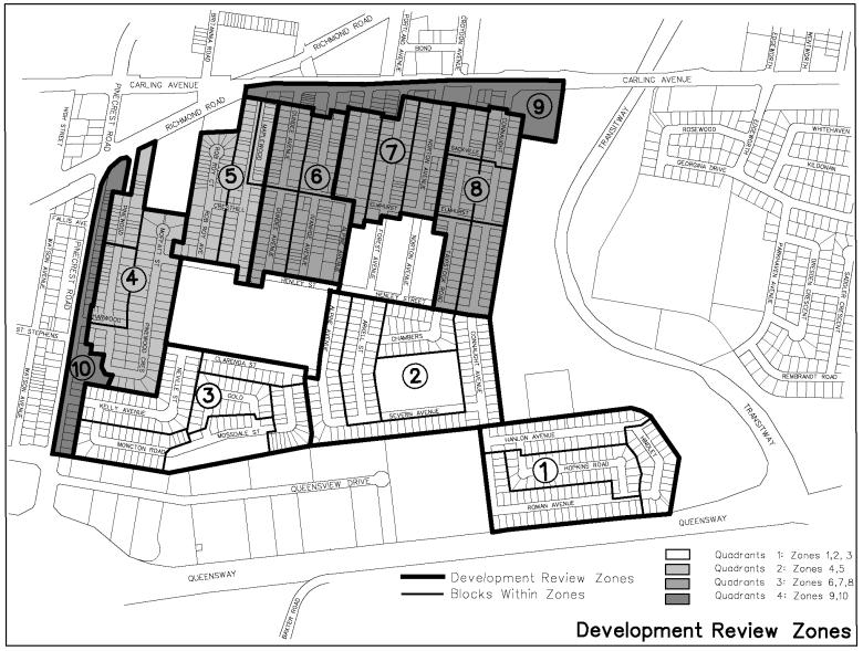
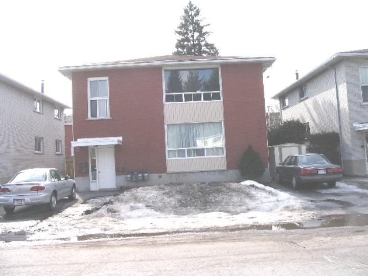
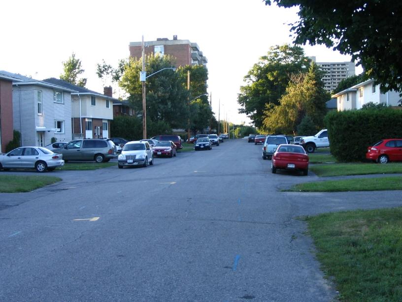
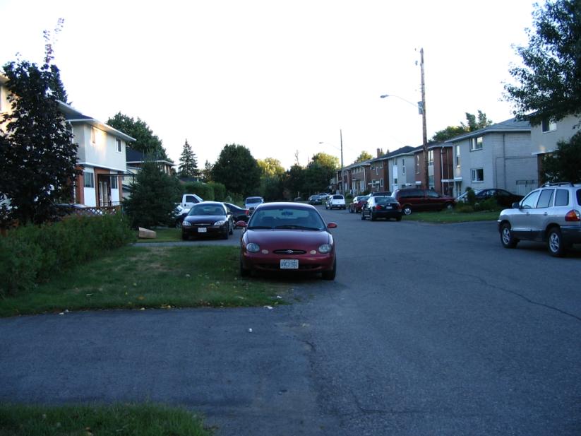
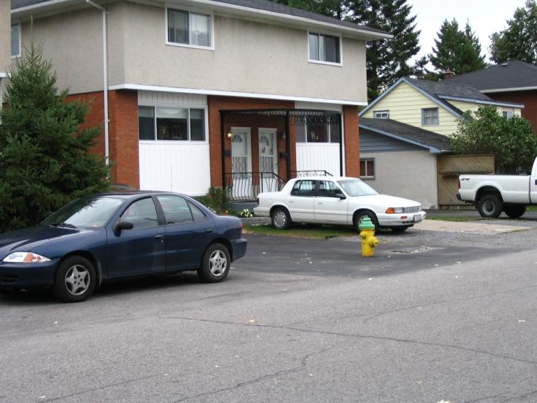
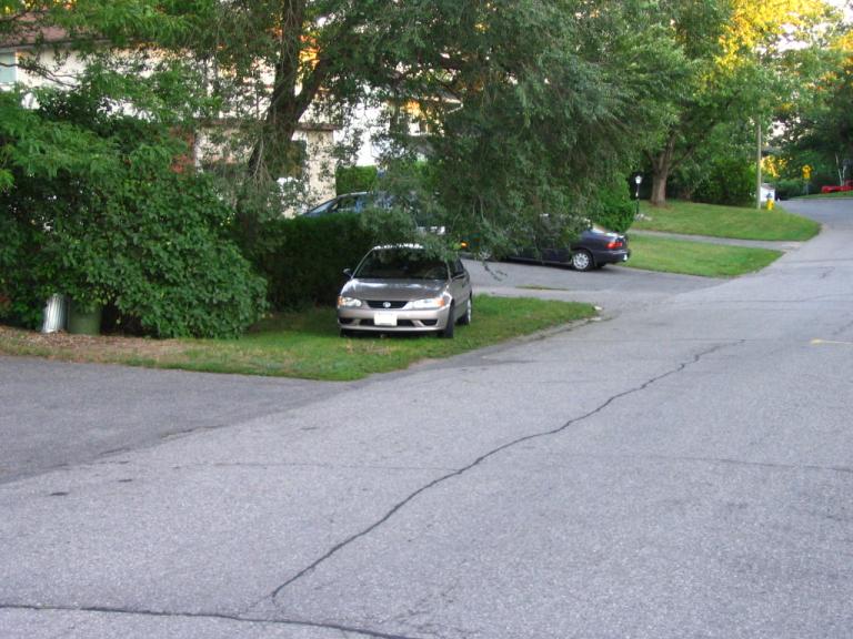
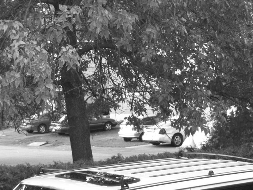
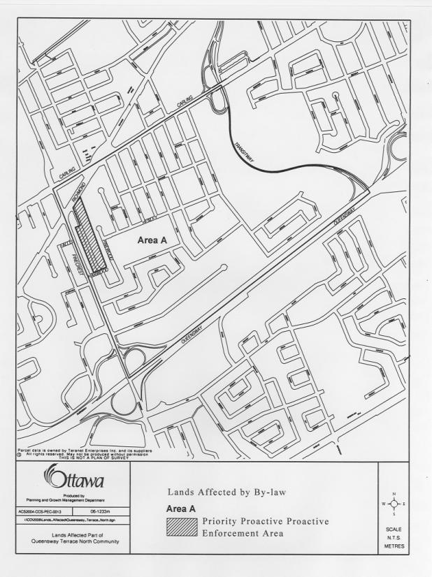
Four
Development Scenarios ((1) Maximum development under existing zoning; (2)
Maximum development under existing zoning with Secondary Dwelling Units (SDUs);
(3) Anticipated Development to 2021; and (4) ‘Limited Development to 120% of
Existing) were developed and compared to the Existing Situation in the
QTN. (NOTE: A maximum, “worst
case” development scenario is where (1)
every lot in R2C Zone with a 15m frontage or greater is developed with
two, semi-detached dwellings, (2) every lot (including all singles, duplexes,
and semi- detached dwellings) is redeveloped with a secondary dwelling unit)
and (3) every secondary dwelling unit has a vehicle.)
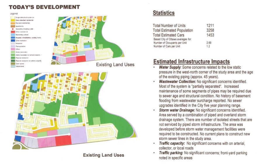
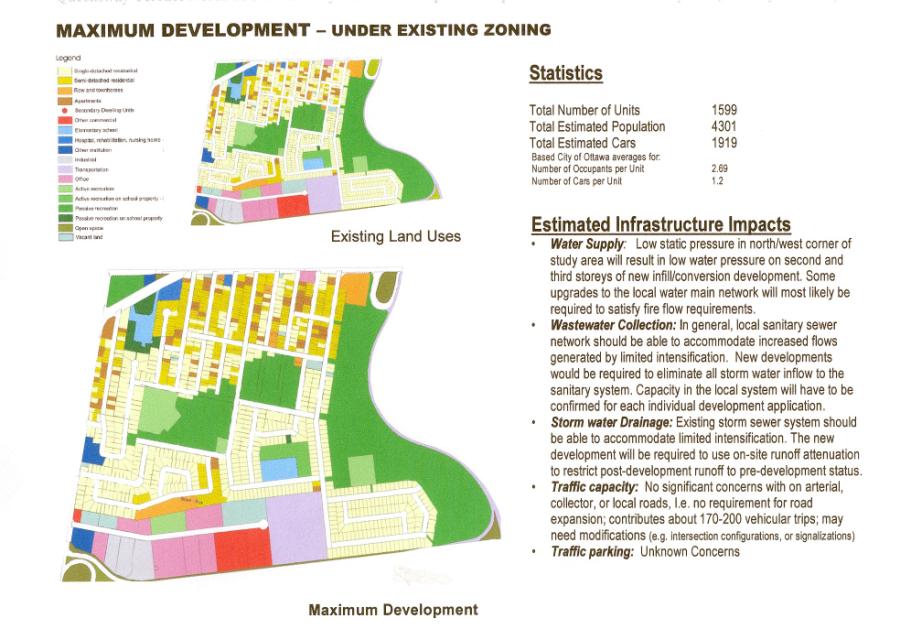
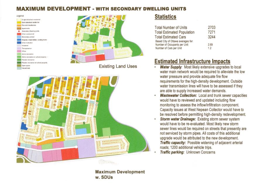
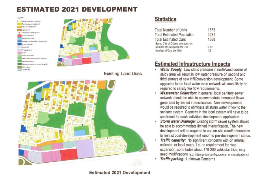
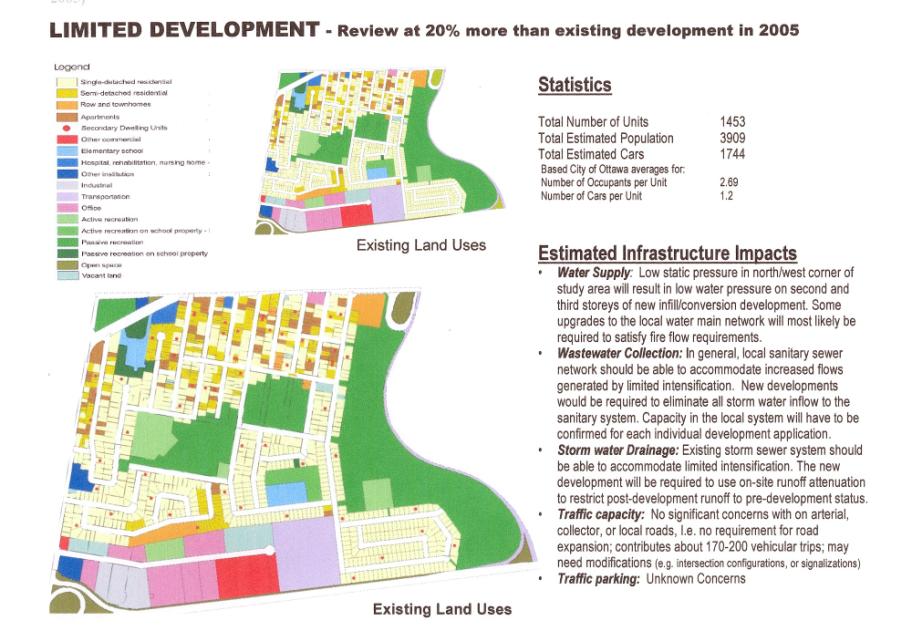
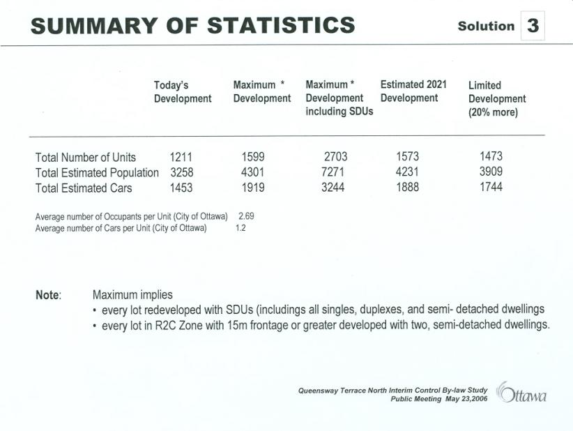
Appendix 12 – QTN
Public Advisory Committee Members – Representation and Role
A Public Advisory Committee
(PAC) was established to provide input and response from the residents of
Queensway Terrace North (QTN) to the Interim Control By-law (January 12, 2005)
with regards how to handle the illegal triplexes in the neighbourhood.
The PAC consisted of a City Planner, some members of the Queensway Terrace
North Community Association, some selected community residents and property
owners and the Ward Councillor.
The following are members of the Queensway Terrace North
(QTN) Public Advisory Committee (PAC):
Alex
Cullen – City of Ottawa
Councillor, Bay Ward
Taavi
Siitam – City of Ottawa
Planner, Planning and Growth Management Department
Henry
Swiech – Queensway
Terrace North Community Association (President)
Susan
Blakeney - Queensway
Terrace North Community Association (Secretary)
Maryann
Kalibatas - Queensway
Terrace North Community Association (Director)
Anna Bevilacqua – QTN
Resident
Jeff Kalibatas - QTN
Resident
E.
J. (Ted) Legg - QTN
Resident
Ed Sabourin – (Alternate) Queensway Terrace North Community Association
(Director)
The
following were original members of the Queensway Terrace North (QTN) Public
Advisory Committee (PAC) but had to withdraw due to other commitments:
Tracy Burton - QTN
Resident
Allan Gordon – ex- QTN
Resident
Tim Stutt - Queensway Terrace North Community Association (Director)
[1] This is based on a maximum, “worst case” development scenario where (1) every lot in R2C Zone with a 15m frontage or greater is developed with two, semi-detached dwellings, (2) every lot (including all singles, duplexes, and semi- detached dwellings) is redeveloped with a secondary dwelling unit) and (3) every secondary dwelling unit has a vehicle.