Report
to/Rapport au :
Planning and Environment Committee
Comité de l'urbanisme et de
l'environnement
and Council / et au Conseil
09 September 2005 / 09 septembre 2005
Submitted by/Soumis par : Ned
Lathrop, Deputy City Manager /
Directeur municipal adjoint
Planning and Growth Management / Urbanisme et Gestion de la croissance
Contact Person/Personne ressource : Grant Lindsay,
Manager / Gestionnaire
Development Approvals / Approbation des
demandes d'aménagement
(613) 580-2424 x13242,
Grant.Lindsay@ottawa.ca
|
SUBJECT: |
|
|
|
|
|
OBJET : |
REPORT RECOMMENDATION
That the Planning and Environment
Committee recommend Council approve an amendment to the former Township of
Rideau Zoning By-Law to change the zoning of 4015 Donnelly Drive from A2
(General Rural) to A2-55 (General Rural - special exception 55) as shown in
Document 1 as detailed in Document 3.
RECOMMANDATION DU RAPPORT
Que le Comité de l’urbanisme et de l’environnement
recommande au Conseil d’approuver une modification au Règlement de zonage de
l’ancien Canton de Rideau en vue de modifier le zonage du 4015, promenade
Donnelly de A2 (rural général) à A2-55 (rural général – exception spéciale 55),
comme il est indiqué dans le document 1 et expliqué dans le document 3.
BACKGROUND
The
site, 4015 Donnelly Drive, is located on the north side of Donnelly Drive, west
of Weedmark and east of Dwyer Hill Road.
The lands to be rezoned are currently vacant, and encompass lands in Lot
20, being south of the unopened road allowance between Concession 1 and the
Broken Front Concession to Donnelly Drive.
The site is currently zoned A2 (General Rural) under the former Township
of Rideau Zoning By-law. The parcel to be rezoned is approximately 7.6 ha in
area.
The
Zoning By-law amendment is pursuant to a severance application to sever a 6 ha
parcel for the purpose of disposing of a surplus dwelling and associated out
buildings. The application for rezoning
has been filed to fulfill the Committee of Adjustment condition for consent.
An
unopened, unmaintained, road allowance running between Concession 1 and the
Broken Front divides the retained lands in two (see Document 1). The unopened road allowance is owned by the
City, constitutes an intervening ownership, and a natural severance. Staff is
not aware of any application to stop up and convey the unopened road allowance.
DISCUSSION
City Council Approved Official Plan
The subject site is designated as “General
Rural” within the City Council Approved Official Plan. Farm-related severances are not permitted in
the General Rural Area.
Notwithstanding the City Council Approved
Official Plan, the Committee of Adjustment heard the application under the
former Regional and Local (Rideau) Official Plan policies and granted
conditional consent for a farm-related parcel.
The subject site is designated as "General
Rural" within the former Region of Ottawa-Carleton Official Plan. The General Rural policies permit farm
related severances and uses in the General Rural designation. The General Rural policies of the former
Regional Official Plan also permit creation of country estate lots. The subject site is designated as
“Agricultural Resource” in the former Township of Rideau Official Plan.
Section 5.2.4.3 in the Rideau Official Plan
permits a farmer who enlarges his/her farm holding by acquiring an additional
farm may sever a parcel of land upon which a farmhouse is made surplus through
farm consolidation.
Details of Proposed Zoning
The site is subject to the development
requirements of the Zoning By-law of the former Township of Rideau. The property is zoned A2 (General Rural).
The applicant has submitted an application for
Zoning By-law amendment to rezone the subject lands from A2 (General Rural) to
A2-55 (General Rural –special exception 55) to prohibit construction of a
dwelling on the lands. The rezoning is
required to fulfil conditions of consent, as well to implement the policies of
the former Rideau Official Plan and 2005 Provincial Policy Statement, which
require that when a farmer purchases additional lands to consolidate with an
existing farm operation, and severs a parcel of land on which is located a
dwelling deemed surplus to the farmer's needs, that the remnant parcel shall be
rezoned to prohibit the construction of a new residence thereon.
RURAL IMPLICATIONS
The rezoning supports and protects the agricultural use of the lands in accordance with the policies of the former Regional and former Rideau Official Plan direction.
CONSULTATION
Notice of this application was carried out in accordance with the City’s Public Notification and Consultation Policy. The Ward Councillor is aware of this application and the staff recommendation. The City did not receive any negative comments or opposition to this application.
FINANCIAL IMPLICATIONS
APPLICATION PROCESS
TIMELINE STATUS
This application was processed by the "On Time
Decision Date" established for the processing of Zoning By-Law Amendment
applications.
SUPPORTING DOCUMENTATION
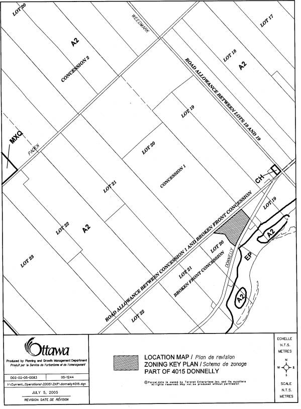
Document 1 Location
Map
Document 2 Explanatory
Note
Document 3 Details
of Recommended Zoning
DISPOSITION
Corporate Services Department,
Secretariat Services to notify the owner A. & A. Schouten C/O Adrian Schouten,
R. R. #3, Richmond, Ontario. K0A 2Z0, Signs.ca, 866 Campbell Avenue, Ottawa,
ON, K2A 2C5 and the Program Manager, Assessment, Department of Corporate
Services of City Council’s decision.
Planning and Growth Management Department to
prepare the implementing by-law, forward to Legal Services Branch and undertake
the statutory notification.
Corporate Services Department, Legal Services
Branch to forward the implementing by-law to City Council.
Document 1
LOCATION MAP
Document 2
EXPLANATORY NOTE
EXPLANATORY NOTE TO BY-LAW - ** [U7]
By-law
Number 2005-** amends Zoning
By-law 428 of 2004 of the former Township of Rideau[U8]. The amendment affects the property at 4015
Donnelly Drive[U9], which
is located on the north side of
Donnelly Drive, west of Weedmark and east of Dwyer Hill. The lands are legally
described as Lot 20, Broken Front Concession[U10][U11], as
shown on the attached Location Map.
The application is to rezone the subject property to rezone the subject lands from “A2 ” (General Rural [U12][U13]to "A2-55" (General Rural -special zone 55)[U14]. [U15] The proposed zoning prohibits residential use of the lands.[U16]
For further information, please contact Terry MacHardy[U17] at 580-2424 ext. 16390[U18].
[U19][U20][U21][U22][U23][U24][U25][U26]
Document 3
DETAILS OF RECOMMENDED ZONING
The property at 4015 Donnelly Drive (Lot 20, Broken Front Concession, in the former Township of Rideau) is rezoned from A2 to A2-55 to prohibit future residential uses.