Report to/Rapport au :
Planning and Environment Committee
Comité de l'urbanisme et de
l'environnement
and Council / et au Conseil
5 August 2005 / le 5 août 2005
Submitted by/Soumis par : Ned Lathrop, Deputy City Manager
/ Directeur municipal adjoint
Planning and Growth Management / Urbanisme et Gestion de la croissance
Contact Person/Personne ressource : Karen Currie,
Manager / Gestionnaire
Development Approvals / Approbation des
demandes d'aménagement
(613) 580-2424 x28310,
Karen.Currie@ottawa.ca
|
SUBJECT: |
ZONING - 2781 and 2901 Lester Road
(FILE NO. D02-02-05-0066) |
|
|
|
|
OBJET : |
REPORT RECOMMENDATION
That
the Planning and Environment Committee recommend Council approve an amendment
to the former Gloucester Zoning By-law to amend the Ra1(E40), Rr1 (Exception
Zone) and Rc2 (E39) zones and Schedule 19E for 2781 and 2901 Lester Road as
shown in Documents 1 and 4 and as detailed in Document 2.
RECOMMANDATION DU RAPPORT
Que le Comité de l'urbanisme et de l'environnement
recommande au Conseil d'approuver une modification au Règlement de zonage de
l'ancienne Ville de Gloucester visant à changer les désignations de zonage
Ra1(E40), Rr1 (zone d'exception) et Rc2 (E39) ainsi que l'annexe 19E, pour ce
qui concerne le 2781 et le 2901, chemin Lester, comme l'illustrent les
documents 1 et 4 et le précise le document 2.
BACKGROUND
This application is for revisions to the
zoning of a 30 hectare vacant parcel of land located within the Blossom Park
neighbourhood. The lands are within a Draft Plan of Subdivision approved in
2003. The zoning for the entire subdivision was also approved in 2003.
Refinements to the development concept and the draft Plan of Subdivision since
the draft plan approval have resulted in the need for the minor zoning
text and schedule changes for these lands.
In addition, three key areas of the development are now the subject of
Site Plan and Part Lot Control applications, which are being processed
concurrently with this Zoning By-law Amendment.
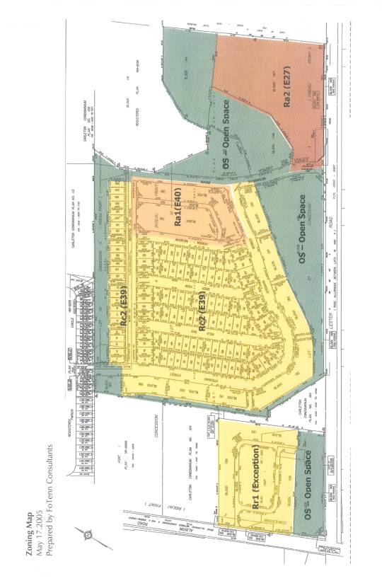
The subject property is located on the north side of Lester Road, between Albion Road and Bank Street (see Document 1). This is an established residential area, which is bounded by Bank Street on the east, Hunt Club Road on the north and by the National Capital Commission (NCC) Greenbelt lands on the west and south.
DISCUSSION
City Council Approved Official Plan
The site lies in the 'General Urban Area', which permits a variety of
land uses. The Official Plan supports various forms of housing densities and
the application will satisfy these polices with the quadruplexes proposed.
Former Regional Official Plan
The entire site lies in the General Urban Area. The General Urban Area
policies support the form of development proposed.
Former City of Gloucester Official Plan
The lands are within "Residential" designation, which permits
a variety of housing types at various densities. The policies do not deal
formally with the form of the housing unit, which is relegated to the Zoning
By-law, hence the request for an amendment to the Zoning By-law.
Details of Proposed Zoning
The
following changes are proposed to the zoning currently in place for these
lands:
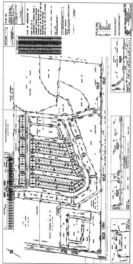
1) Ra1(E40) - Low Density Apartment (Block
136 and 138 on draft plan) (see Document 3). The site plan application for
Blocks 136 and138 proposes development on both public and private streets. This was not originally contemplated by the
applicants during preparation of the original Zoning By-law amendment for these
lands. In addition, a new housing form,
a ‘quadruplex’ is proposed for Block 138. The zone changes reflect the design
parameters established for this building type.
2) Rezone Lands from Rc2 (E39) to Rr1 (Exception) (Blocks 139, 140, 141 on draft plan: north-east corner of Lester and Albion Roads). This portion of the development was originally to be serviced by a public street. Now the developer is proposing an Adult Lifestyle development that would be serviced by a private road. The Rc2 (E39) zone did not anticipate development of units on a private street. Therefore, the Zoning By-law amendment application proposes to rezone this portion of the Lester Road development from Rc2 (E39) to Rr1 (Exception) Zone.
3) Amendments to the current Rc2 (E39) Zone applicable to the lands. In
order to allow the flexibility in the design guidelines for the development,
the applicant has requested that the requirement for a ‘maximum’ building line
setback requirement to a street lot line be removed. This is currently established as 4.0 metres in order to comply
with the original design guidelines prepared by the applicants architect to
control the streetscape and distances the setback between buildings were fromand the street lot line.
With the refinements to the design guidelines and testing of the concepts, the
applicant would like to remove this performance criterion to provide
flexibility in the design.
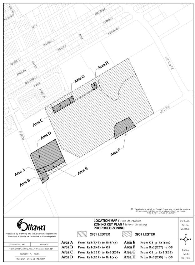
4) Schedule 19E of the
Gloucester Zoning By-law is proposed to be modified in the following manner:
(see attached Documents 1 and 4)
·
The corner of Lester and Albion Roads is proposed
to be rezoned from Ra1(E43) to OS – Open Space, as the Open Space area is being
expanded.
·
The lots zoned Rs1(E25) will be rezoned to
Rc2(E39).
·
A portion of the west side of the access road
(Meandering Brook) into the development will be rezoned from Ra2(E27) to OS
(Open Space) to reflect the realignment of the a tributary of to Sawmill Creek.
·
The OS Zone along the ‘promenade park’ will be
shifted to reflect the latest 4M Plan revision.
·
Blocks 139, 140 and 141 on the draft
plan are being rezoned from Rc2 (E39) to Rr1 (Exception), a zone that would be
expanded south slightly.
The requested
zone amendments are supported as they are in conformity with the policies of
the City Council Approved Official Plan. Among other things, these amendments
introduce a unique housing type, the “quadruplexes”, which respects a prominent
hedgerow that the applicant is seeking to preserve through the design of the
subdivision. The amendments also increase the amount of passive open space that
will be deeded to the City and allow for the creation a landscape feature at
the intersection of Lester and Albion Roads.
Staff support the approval of this rezoning.
The following concurrent applications have been filed on these lands: a
site plan application (File No. D07-12-05-0109); and part lot control
application (File No. D07-08-05-0015).
CONSULTATION
Notice of this application was
carried out in accordance with the City’s Public Notification and Consultation
Policy. The Ward Councillor is aware of this application. The City did not receive anyother
negative comments or opposition to this application.
FINANCIAL IMPLICATIONS
APPLICATION PROCESS TIMELINE STATUS
This application was processed by the "On Time
Decision Date" established for the processing of Zoning By-Law Amendment
applications.
SUPPORTING DOCUMENTATION
Document 1 Location
Map
Document 2 Details of
Recommended Zoning
Document 3 Revised Draft Plan
of Subdivision
Document 4 Proposed Zoning
Plan
DISPOSITION
Corporate Services Department, Secretariat
Services to notify the owner (Miriam Lynch, FoTenn Consultants Inc., 223 McLeod Street, Ottawa.
On. K1A 0K4), 2005 Signs.ca, 866 Campbell Avenue, Ottawa,
ON, K2PA
0Z82C5,
and the Program Manager, Assessment, Department of Corporate Services of City
Council’s decision.
Planning and Growth Management Department to prepare the implementing
by-law, forward to Legal Services Branch and undertake the statutory
notification.
Corporate Services Department, Legal Services Branch to forward the
implementing by-law to City Council.
LOCATION MAP Document
1
DETAILS OF RECOMMENDED ZONING Document 2
The zoning
for the lands known municipally as 2781 and 2901 Lester Road be amended as
follows:
1) Notwithstanding Section 2.0, Definitions, the following definitions “ Quadruplex” shall apply:
a) Quadruplex Dwelling, which means a detached building having four or more dwelling units each of which shares only a vertical common or party wall or walls with two other dwelling units, and; has a separate entrance on each of at least two sides.
b) Private Quadruplex Dwelling, which means a detached building having four or more dwelling units each of which shares only a vertical common or party wall or walls with two other dwelling units, and; has a separate entrance on each of at least two sides, and; has access to a private street or driving aisle, and; is located on an exclusive use residential parcel.
c) Street Quadruplex Dwelling, which means a quadruplex dwelling within which each dwelling unit is on a lot or part of a lot that has separate frontage on a public street.
2) For the lands zoned Ra1(E40) - Low Density Apartment (Block 136 and 138 on draft plan: see Document 3), the following modifications are proposed:
a) Notwithstanding 6.14.1 for the lands zoned Ra1(E40) following additional uses shall be permitted:
- Street Row Dwelling;
- Quadruplex Dwelling
- Private Quadruplex Dwelling
- Street Quadruplex Dwelling
b) Notwithstanding 6.14.4 for the lands zoned Ra1(E40) the following provisions shall apply:
i) Street Row Dwellings:
Building line requirements for street row dwellings to a:
Interior lot line 1.2 metres
Interior dividing lot line 0.0 metres if there is no opening in the facing wall and/or 1.2 metres if there is an opening in the facing wall
Back Lot line 5.0 metres
Minimum Lot Area for a street row dwelling: 150 m2
Minimum Lot Frontage for a street row dwelling: 6 metres
ii) Private Row Dwellings
Building line requirements for private row dwellings to a:
Back Parcel boundary 5.0 metres
iii) Street Quadruplex Dwellings
Building line requirements for street quadruplex dwellings to a:
Interior lot line 1.2 metres
Interior dividing lot line 0.0 metres if there is no opening in the facing wall and/or 1.2 metres if there is an opening in the facing wall
Back Lot line 0.0 metres
iv) Private Quadruplex Dwellings
Building line requirements for private quadruplex dwellings to a:
Driving aisle parcel boundary 5.5 metres
Interior parcel boundary 1.2 metres
Interior dividing parcel boundary 0.0 metres
Back Parcel boundary 0.0 metres
The amenity area requirement is a minimum of 45 m2 per street row and private row dwelling unit.
The provisions of Section 6.2.4.2, Visitor Parking, do not apply.
The provisions of Section 6.14.4 (23) do not apply.
2 parking spaces shall be provided per private and street quadruplex dwelling. These parking spaces shall be provided in accordance with Section 6.2.4.
The provisions of Section 6.2.2, Separation Distance of Facing Walls on the Same Lot, do not apply.
Notwithstanding Section 3.9 Permitted Projections, the required yards shall correspond to their equivalent yard in a private development (e.g. street yard should be the same as the driving aisle parcel boundary).
Notwithstanding Section 3.9.1, the permitted projections for covered, but unenclosed porch, step, or veranda or gazebo, in the street yard, the amount of projection permitted in 2.0 metres.
3. a) Rezone lands from Rc2 (E39) to Rr1 (Exception) (Blocks 139, 140, 141 on draft plan of subdivision) (Area D on Document 1)
b) Notwithstanding Section 6.13.2 to the contrary, the following modifications are proposed for the lands zoned Rr1(Exception):
i) Building Line Requirement (Street Lot Line): Reduce from 5 metres to 4.5 metres;
ii) Building Line Requirement (private semi-detached or row) - Driving aisle parcel boundary: Reduce from 5 metres to 4.75 metres;
iii) On a corner parcel the building line requirement to one driving aisle parcel boundary may be reduced to 2.5 metres (from 3.0 metres);
c) Notwithstanding the requirements of subsection 6.2.4 Parking Requirements, the following provisions shall apply:
- Semi-detached Dwelling, Private 2 spaces per dwelling
- Row Dwelling, Private 2 spaces per dwelling
- Visitor parking spaces shall be provided in accordance with the following: Minimum of 7 spaces shall be provided.
d) Notwithstanding the provisions of Subsection 3.2.13, the following provisions shall apply where more than one single or semi-detached dwelling or semi-detached dwelling, private or private row dwelling is to be developed on a lot:
i) Each exclusive use residential parcel shall have a parcel width, which equals or exceeds a minimum frontage of 8.0 metres;
ii) Each exclusive use parcel shall have an area, which equals or exceeds a minimum area size of 200 square metres.
e) Notwithstanding the provisions of Section 3.9 Permitted Projections, the required yards shall correspond to their equivalent yard in a private development.
f) The amenity area requirement is a minimum of 70 m2 per dwelling unit.
g) Notwithstanding Section 3.9.1, the permitted projections for covered, but unenclosed porch, step, or veranda or gazebo, in the street yard (Albion Road frontage), the amount of projection permitted in 3.0 metres.
h) Notwithstanding Section 3.9.1, the permitted projections for
covered, but unenclosed porch, step, or veranda or gazebo, in the driving
aisle parcel boundary, the amount of projection permitted in 2.0 metres.
4) The Rc2 (E39) Zone
applicable to the lands is proposed to be amended by deleting the words ‘maximum 4.0 metres’ at
Section 6.18.39 10).
5) Schedules 18B and 19E of the Gloucester Zoning By-law is proposed to be
modified in the following manner: (see Document 1)
i)
Area
A to be rezoned from Ra1 (E43)
to Rr1 (Exception);
ii)
Area B____ to be rezoned from Ra1 (E43) to
OS (Open Space);
iii)
Area C to be rezoned from Rs1 (E25) to Rc2 (E39);
iv)
Area
D to be being rezoned from Rc2 (E39) to Rr1 (Exception);
v)
Area
E to be rezoned from OS (Open Space) to Rr1 (Exception);
vi)
Area F to be rezoned from Ra2 (E27) to OS (Open
Space);
vii)
Area
G to be rezoned from OS (Open Space) to Rc2 (E39);
viii)
Area
H to be rezoned from Rc2 (E39) to OS (Open Space).
REVISED DRAFT PLAN OF SUBDIVISON Document 3
PROPOSED ZONING PLAN Document 4