Report to/Rapport au :
Planning and Environment Committee
Comité de l'urbanisme et de
l'environnement
and Council / et au Conseil
14 January 2006 / le 14 janvier 2005
Submitted by/Soumis par : Ned
Lathrop, Deputy City Manager / Directeur municipal adjoint
Planning
and Growth Management / Urbanisme et Gestion de la croissance
Contact Person/Personne ressource : Karen Currie,
Manager / Gestionnaire
Development Approvals / Approbation des
demandes d'aménagement
(613) 580-2424 x28310, Karen.Currie@ottawa.ca
|
SUBJECT: |
|
|
|
|
|
OBJET : |
REPORT RECOMMENDATION
That the Planning and Environment
Committee recommend Council approve an amendment to the former City of Ottawa
Zoning By-Law to change the zoning of 3201 Conroy Road for the northerly
portion of the property from IL F(1.0) - Light Industrial to CG [XXX] - General
Commercial as shown in Document 1 and detailed in Document 2.
RECOMMANDATION DU RAPPORT
Que le Comité de l’urbanisme et de l’environnement recommande au Conseil d’approuver une modification au Règlement de zonage de l’ancienne Ville d’Ottawa en vue de remplacer la désignation de zonage IL F(1.0) – Industrie légère de la partie nord du 3201, chemin Conroy par la désignation CG [XXX] – Commercial général afin de permettre un centre commercial, comme il est représenté dans le document 1 et indiqué en détail dans le document 2.
BACKGROUND
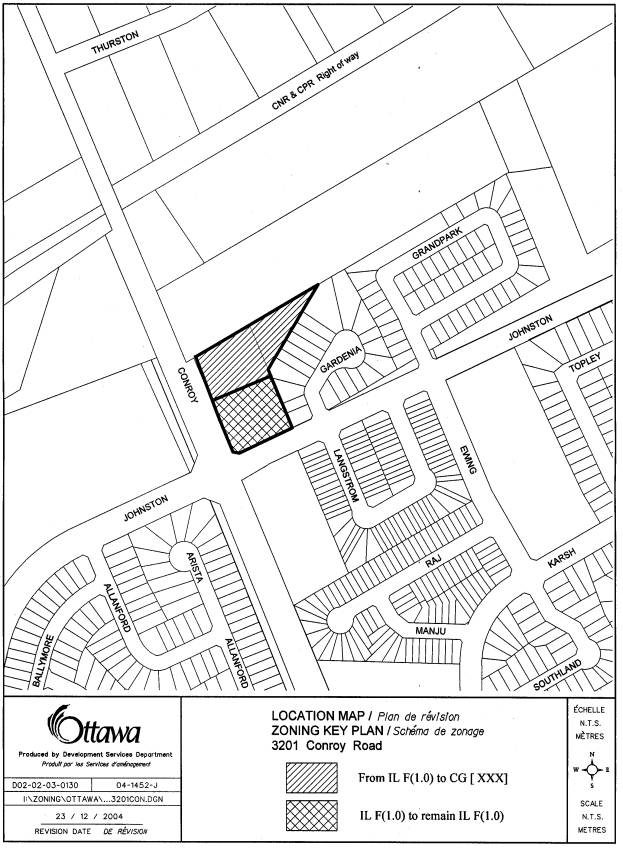
The 1.32 hectare property is located on the northeast
corner of Conroy Road and Johnston Road.
It is adjacent to residential development on the east, south and west,
and to the north is a woodland.
The applicant wishes to amend the zoning to add
a wider variety of retail and commercial uses to the property to permit the
construction of a proposed 1 114.8 m² plaza and a 278.7 m² fast food restaurant
with a drive-thru that would serve the local residents.
The southern portion of the property is
currently occupied by a gas bar, convenience store and a car wash, and will
remain zoned IL F(1.0) – Light Industrial.
Existing Zoning
The land is currently zoned IL (Light
Industrial). This designation permits a
limited number of commercial uses such as a bank, convenience store,
laundromat, personal service business and restaurants. These uses are subject to a maximum gross
floor area of 280 m² and the cumulative total must not exceed 20% of the floor
space index or 20% of the lot area where there is no floor space index.
Proposed Zoning
The application is to rezone the land to CG [XXX] (General Commercial Subzone Exception No. XXX). The exception is that no residential uses will be permitted on this site and that a 3.0 metre wide landscaped strip will be required adjacent to the lands retaining a Light Industrial zone designation to the south. The purpose of the landscape strip is to prevent vehicular access between the proposed neighbourhood plaza and an existing gas bar and car wash at the northeast corner of Johnston Road and Conroy Road.
DISCUSSION
Council Approved Official Plan
The Council Approved Official Plan designates this property as General
Urban Area. This designation permits a
full range of residential development as well as permitting employment,
service, cultural, leisure, entertainment and institutional uses with the goal
to attain complete and sustainable communities. This would include a wide range of retail commercial development
from a corner store to a shopping centre, where appropriate. To ensure that land uses are appropriate
where proposed, the Official Plan contains polices which indicate that development
should form an integral part of the community and be compatible with
surrounding neighbourhood uses. To
achieve this, the amendments to the Zoning By-law will regulate the location,
scale and type of land uses. The
Strategic Directions Section of the Council Approved Official Plan for
development is to create livable communities that have a balance of facilities,
including commercial uses servicing neighbouring residential development. New developments are supported by the
Official Plan where redevelopment optimizes underutilized land or vacant lands.
Former Regional Official Plan
The Official Plan of the former Region designates the subject property
as General Urban Area. This
designation, like that of the new Official Plan, anticipates a wide range of
uses, including the proposed office use.
Polices contained within that plan directs that commercial development
only occur on roads with a planned capacity to accommodate additional traffic
and that the commercial activity not have an adverse impact on neighbouring
residential development. This
development is sensitive to this criteria.
Former City of Ottawa Official Plan
The former City of Ottawa Official Plan designates this property as
Residential. Non-residential uses are
permitted in areas designated Residential Area, provided certain policy
guidelines are adhered to. Some of
these guidelines include that non-residential development occur in isolation
from, or are on the periphery of existing residential development, that such
uses are located along major collector or arterial roadways, and that the use
be compatible with surrounding residential uses. In addition, non-residential uses are not to negatively impact
adjacent residential uses in their generation of noise, fumes or lighting
glare.
Conroy Road Study Area
The subject property lies within an area being reviewed in the Conroy Road Study. Which involves the industrially zoned lands. The study area is generally bounded by the Canadian National Rail Line to the north, the Hawthorne Business Park to the east, Johnston Road to the south and Conroy Road to the west. The study identifies the subject property as vacant industrial lands and contemplates either commercial or industrial uses on the property. The final recommendations of the Conroy Road Study are anticipated to be brought to Planning and Environment Committee on March 22, 2005.
The property does not directly impact any of the
surrounding residential properties. The
abutting residential units to the east are separated from the site by a sound
barrier ranging in height from 7.4 metres to 2.4 metres. The barrier consists of a combination of
earth berming at the bottom with sound fencing on top, which was installed to
provide the necessary buffer to enable the residential units to develop while
satisfying buffering from the rail lines.
The balance of the residential community is south of Johnston Road. The site fronts Conroy Road, which is an
arterial roadway. This location will
provide for convenient access while not directly affecting the residential
community.
Upon review of the application, it is the Department’s position that the proposed zoning amendment to allow a shopping plaza conforms with applicable criteria set out in the new and former Official Plans and is appropriately located in relation to the surrounding community.
ENVIRONMENTAL IMPLICATIONS
The Municipal Environmental Evaluation Process (MEEP)
checklist indicates that there will be potential impacts on trees and shrubs as
a result of this application. This will
be reviewed as part of the site plan approval process.
The Ottawa Forests Advisory Committee advises
that a Tree Preservation Plan will be required at the site plan stage
highlighting existing trees and shrubs that are to be retained, relocated
and/or removed. The Committee also
recommends preserving the best mature trees along the northern edge of the
subject property. This would allow for
a buffer adjacent to the property, provide shade, and add some interest to the
site.
CONSULTATION
Notice of this application was carried out in accordance with the City’s Public Notification and Consultation Policy. Information signs were posted on-site indicating the nature of the application. The Ward Councillor is aware of this application and the staff recommendation. Councillor Diane Deans expressed a concern regarding the potential impact development of this site will have onto Conroy Road. The base of this concern is centered on the fact that the vehicular access from Conroy Road will be limited to right-in and right-out vehicular movements only. The applicant is in the process of preparing a traffic impact statement to address this concern. Any recommendation from this impact statement will be implemented through the Site Plan Control process. The City did not receive any negative comments or opposition to this application.
FINANCIAL IMPLICATIONS
APPLICATION PROCESS TIMELINE STATUS
The application was not processed within the
timeframe established for the processing of Zoning By-Law amendments due to the
application being placed on hold while the applicant explored vehicular access
options.
SUPPORTING DOCUMENTATION
Document 1 Location
Map
Document 2 Details of
Recommended Zoning
DISPOSITION
Department of Corporate Services, Secretariat
Services to notify the owner Marcel Benjamin, Suncor Energy Products, 36 York
Mill Road, North York, ON, M2P 2C5, applicant Gerry McGuinness, 600-700 Kerr
Street, Oakville, ON, L6K 3E4, All Signs, 8692 Russell Road, Navan, ON K4B 1J1, and the Program Manager,
Assessment, Department of Corporate Services of City Council’s decision.
Planning and Growth Management Department to prepare the implementing
by-law, forward to Legal Services Branch and undertake the statutory
notification.
Department of Corporate Services, Legal Services Branch to forward the
implementing by-law to City Council.
LOCATION MAP Document
1
DETAILS OF RECOMMENDED ZONING Document 2
Zoning Details for Zoning By-law, 1998
The following
zoning change will be made to the property at 3201 Conroy Road shown on
Document 1:
Change the
Zoning from IL F(1.0) to CG[xxx] with the following exceptions:
1) Create a site specific exception zone to prohibit residential uses on the subject property, and to require a 3.0 metre wide landscaped strip of land adjacent to the lands to the south of the subject property that retain a Light Industrial zone designation.