Report to/Rapport au :
Planning and Environment Committee
Comité de l'urbanisme et de
l'environnement
and Council / et au Conseil
15 November 2004 / le 15 novembre 2004
Submitted by/Soumis par : Ned Lathrop, Deputy City Manager/Directeur
municipal adjoint,
Planning
and Growth Management/Urbanisme et Gestion de la croissance
Contact Person/Personne ressource : Grant Lindsay,
Manager / Gestionnaire
Development Approvals / Approbation des
demandes d'aménagement
(613) 580-2424 x13242, Grant.Lindsay@ottawa.ca
|
SUBJECT: |
|
|
|
|
|
OBJET : |
REPORT RECOMMENDATION
That the Planning and Environment
Committee recommend Council approve an amendment to the former Township of West
Carleton Zoning By-Law to adjust the zoning boundaries of 2901 Carp Road
between the Open Space Zone (OS-4) and the
Residential Country Lot Zone (RCL-20) as shown in Document 1.
RECOMMANDATION DU RAPPORT
Que le Comité de l’urbanisme et de
l’environnement recommande au Conseil d’approuver une modification au Règlement
de zonage de l’ancien Canton de West Carleton afin de redresser les limites de
zonage du 2901, chemin Carp entre la zone d’espace libre (OS-4) et la zone de
lot de campagne résidentiel (RCL-20), comme il est indiqué dans le document 1.
BACKGROUND
The subject land is a portion of 2901 Carp Road. The land to be rezoned is within a draft
plan of subdivision for 37 residential country lots, which previously received
draft subdivision approval, and is currently subject to an application for an
extension of draft plan approval.
The vacant parcel of land is to be developed
for an estate lot subdivision surrounding a private lake. The land was zoned in
1987 to permit the proposed development, with the lots being zoned Residential
Country Lot, RCL-20, and the private lake and access zoned Open Space, OS-4,
permitting a private park and a marine facility. A recent survey of the
property by the new owner has determined that the boundaries of the Open Space
Zone approved in 1987 do not correspond to the actual location of the existing
lake, and that the rear portion of eight lots abutting the lake are located
within the Open Space Zone. Due to this inaccurate zoning boundary, the eastern
portion of the lake is located within the Residential Country Lot Zone.
In addition, an adjustment of the zone boundary
is required to reflect the revised location of the lake access. Under the draft
plan of subdivision previously approved, a 0.8 ha lot was zoned Open Space to
provide lake access for residents. This access has been realigned and reduced
in size to 30 metres wide, requiring rezoning of the remainder of that lot from
Open Space to Residential Country Lot.
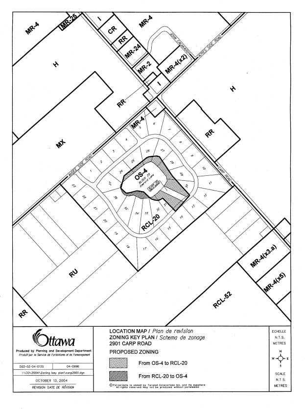
The purpose of this application is to request
an adjustment to the boundaries of the RCL-20 Zone and the OS-4 Zone to reflect
the realigned location of the public access, and the boundaries of the existing
lake. A portion of the land is being rezoned from RCL-20 to OS-4, and another
portion is being rezoned from OS-4 to RCL-20, as shown on the attached location
plan.
DISCUSSION
The subject property is designated 'General
Rural Area' in the Council Approved Official Plan. This designation permits a variety of land uses including farms,
rural housing, estate lot residential development, as well as industrial and
commercial development. The intent is to accommodate a variety of land uses
that are appropriate for a rural location. Country lot development is permitted
by this designation.
The property is also designated 'General Rural Area' in the former
Regional Official Plan, which permits the proposed use. The former Township of West Carleton
Official Plan designates the property as Marginal Resource. This designation
applies to land not suited to agricultural use, and permits recreational,
commercial, industrial and residential uses. Country lot development is
compatible with this designation.
The current boundary alignment results in nine building lots being partially located within the Open Space Zone. The proposed Zoning By-law amendment is appropriate to ensure that the restrictions of the Open Space Zone do not affect the residential lots to be developed. The minor zoning boundary realignments proposed will have no impact on surrounding properties, and are appropriate to permit development of the residential lots.
CONSULTATION
Notice of this application was carried out in accordance with the City’s Public Notification and Consultation Policy. Information signs were posted on-site indicating the nature of the application. The Ward Councillor is aware of this application and the staff recommendation. The City did not receive any negative comments or opposition to this application.
FINANCIAL IMPLICATIONS
APPLICATION PROCESS TIMELINE STATUS
This application was processed within the timeframe
established for the processing of Zoning By-Law Amendment applications.
SUPPORTING DOCUMENTATION
Document 1 Location
Map
Document 2 Explanatory Note
DISPOSITION
Department of Corporate Services, Secretariat
Services to notify the owner (1332741 Ontario Inc., R.R. 2 Aston, ON K0A 1B0),
applicant (McIntosh Perry Consulting Engineers, 115 Walgreen Road, Carp, ON K0A
1L0), All Signs, 8692 Russell Road, Navan, ON
K4B 1J1, and the Program Manager, Assessment, Department of Corporate
Services of City Council’s decision.
Development Services Department to prepare the implementing by-law,
forward to Legal Services Branch and undertake the statutory notification.
Department of Corporate Services, Legal Services Branch to forward the
implementing by-law to City Council.
LOCATION MAP Document
1
EXPLANATORY NOTE Document
2
By-law Number 2004- amends Zoning By-law 266-81 of the former Township of West
Carleton. The amendment affects the
property at 2901 Carp Road, which is located on the west side of Carp Road,
south of McGee Side Road, as shown on the attached Location Map. The property
is zoned to permit estate lots surrounding a private lake.
The
application is to realign the boundary between the Residential Country Lot Zone
(RCL-20) and the Open Space Zone (OS-4) currently affecting the property. The
RCL Zone permits single detached dwellings on lots of 0.8 ha, while the OS-4
Zone permits a park or private marina.
The current zoning was enacted in 1987, and it has been determined that
the Open Space Zone does not reflect the correct location of the existing lake
and proposed access pathway.
The proposed
zoning will rezone some portions of the property from OS-4 to RCL-20, and other
portions from RCL-20 to OS-4., to correspond with the limits of the lake and
future pathway.
For further
information, please contact Kathy Rygus at 580-2424 ext. 29318.