Report to/Rapport au :
Planning and Environment Committee
Comité de l'urbanisme et de
l'environnement
and Council / et au Conseil
12 October 2004 / le 12 octobre 2004
Submitted by/Soumis par : Ned Lathrop, Deputy City Manager / Directeur municipal adjoint
Planning and Growth Management / Urbanisme
et Gestion de la croissance
Contact Person/Personne
ressource : Karen Currie, Manager / Gestionnaire
Development Approvals / Approbation des demandes
d'aménagement
(613) 580-2424 x28310, Karen.Currie@ottawa.ca
|
SUBJECT: |
OFFICIAL PLAN AND
ZONING - 4232 INNES ROAD -D01-01-04-0015, D02-02-04-0076 |
|
|
|
|
OBJET : |
PLAN
OFFICIEL ET ZONAGE - 4232, CHEMIN INNES - D01-01-04-0015 ; D02-02-04-0076 |
REPORT RECOMMENDATION
That the Planning and Environment Committee recommend that Council:
1. Approve an application to amend the Official Plan of the former City of Cumberland and to change the Official Plan designation of 4232 Innes Road from Mixed Use Business Park - Category B to Community Commercial as detailed in Document 3.
2. Approve an application to amend the former City of Cumberland Urban Zoning By-law to change the zoning of 4232 Innes Road from Industrial Service (MS1 and MS2) and Industrial General (MG) to Community Commercial (CC-X5) as shown in Document 1 and detailed in Document 4.
RECOMMANDATION DU RAPPORT
Que le Comité de l'urbanisme et de l'environnement recommande au Conseil municipal :
1. d'approuver une demande en vue de modifier le Plan officiel de l'ancienne Ville de Cumberland et de faire passer la désignation au Plan officiel du 4232, chemin Innes de parc d'affaires à usage mixte - catégorie B à communauté commerciale comme le détaille le document 3.
2. d'approuver une demande en vue de modifier le Règlement de zonage urbain de la Ville de Cumberland afin de faire passer le zonage du 4232, chemin Innes de service industriel (MS1 et MS2) et industriel général (MG) à communauté commerciale (CC-X5) comme le montre le document 1 et le détaille le document 4.
BACKGROUND
Site Location
The owner of
the property at 4232 Innes Road has applied for amendments to the former City
of Cumberland Official Plan and Zoning By-law to permit large-format retail
uses on the subject property.
The lands
being considered under this application can be legally described as Part of Lot
1, Concession 2, Reference Plan 50R-579. The property is located on the south
side of Innes Road across from the southern end of Avenue Du Grand Bois, and
west of Lanthier Drive (see Document 1).
Description
of Site and Surroundings:
Direct access
to the site is available from Innes Road.
Indirect access is possible from Lanthier Drive through the parking lot
of the adjoining commercial site which is scheduled to be built in the near
future. The lands affected by the
development applications encompass approximately 5 hectares and are
predominantly flat, with little vegetative cover. This development proposal
would form an extension of the new "Loblaws" development and will
share a common entrance from Innes Road that will be signalized.
A range of
commercial uses exist east of the site including offices, retail and
warehousing. The southern side of Innes Road consists of existing and proposed
commercial developments. Properties
situated to the west and south of the subject site are vacant. The residential community of Queensview
Heights is located on the north side of Innes Road.
Development
Proposal
The
development proposal includes three stand-alone retail and service type
buildings. One of the buildings will be divided to accommodate three different
commercial uses, and will be arranged in a linear fashion. The proposed
buildings will vary in size from 688 - 15,302m2, for a total of 17,104 m2. All
buildings will have a maximum height of 1 storey. The development proposal for
this site is meant to be an extension of a large format retail complex located
immediately east of the site.
It is
important to note that the lands identified under this application are under
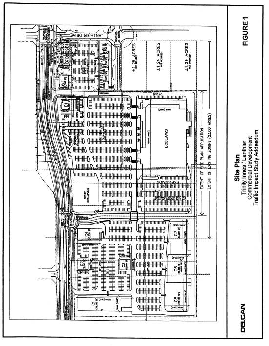
the same ownership as the development east of the site. A conceptual site plan has been submitted
for reference (see Document 2).
Purpose of
Official Plan and Zoning By-law Amendment Proposal
The purpose
of the applications to amend the Official Plan and Zoning By-law is to permit
large-format retail development. The
proponent seeks to change the Official Plan designation of 4232 Innes Road from
Mixed Use Business Park - Category B to Community Commercial to permit
large-format retail uses.
The current
Zoning By-law zones the lands Industrial Service (MS1 and MS2) and Industrial
General (MG). The proponent has requested a change that would create a new
Commercial Community Zone (CC-X5). The provisions of this new zone are similar
to the adjacent CC-X1. Through
correspondence dated September 7, 2004, the applicant's agent has requested
that the zoning application be amended to revise the parking stall lengths,
aisle widths, parking requirement ratios, and loading space requirements.
DISCUSSION
Council Approved Official Plan Designation
The Council Approved Official Plan designates the subject property as "Employment Area". The intent of this designation is to promote centres of employment, while supplying products and services that serve the city's office and commercial sectors. This category permits industrial and employment-generating uses such as warehousing and distribution, manufacturing, storage, construction, office, institutional and research and development.
The plan states that Employment Areas should maintain the primary character as industrial areas, although the designation also encourages complementary non-industrial uses in the area. These non-industrial uses include convenience retail, personal service businesses and recreational uses that will cater to employees in this area, the general public and passing traffic. The purpose of this designation is to allow for the concentration of at least 2,000 jobs. Numerous appeals to the Ontario Municipal Board were received against this designation in the new Official Plan. These appeals deal predominantly with issues concerning the amount and scale of retail permitted within the Employment Areas
On September 25, 2003, Planning and Environment Committee (PEC) directed the Department to review and report back to the Committee on the implications of re-introducing large format retailing to the Employment and Enterprise Area designation in the Official Plan. This direction was approved by Council on October 8, 2003.
The review is being carried out through sessions facilitated by the Department and commenced at the beginning of April, 2004. The sessions involve staff and those parties who have appealed the retail / commercial policies of the Council Approved Official Plan. It is anticipated that this process will conclude with a report to PEC and recommended changes to the Plan early in 2005.
The applicant is participating in these discussions but wishes to proceed with the development applications prior to consideration of the Department's report.
Former Regional Official Plan (ROP)
The former Regional Official Plan (ROP) designates this site "Business Park". This designation includes industrial and business parks, research parks, warehousing and manufacturing areas, as well as research and high-technology business parks. Business Parks are characterized as having a road network that facilitates public transit service, direct access to a regional road or provincial highway and to designated truck routes. Non-residential uses such as retail, office, small-scale institutional and recreational uses are also permitted in this designation.
The criteria for developing Business Parks are outlined in the ROP. The Plan encourages a mix of land uses within the designated area to provide basic goods and services to employees of the park. In this instance, the type and extent of retail space proposed by the applicant can be considered to serve the business and residential community, acting as an extension of the adjacent development.
Former City of Cumberland Official Plan
The former City of Cumberland Official Plan designates the subject property "Mixed Use Business Park - Category B". This designation promotes a wide range of mixed use business and industrial uses such as transportation and services, warehousing, industrial condominiums and commercial-industrial uses. Commercial-service uses are encouraged along Innes and Tenth Line Roads in the former City of Cumberland. Heavier and more traditional industrial uses under this designation are discouraged along these roads and should be integrated within the interior of the Business Park area.
This designation was put in place to take advantage of a unique opportunity to develop business parks on larger tracts of serviced land within the former municipality that were located along major transportation corridors, away from incompatible development and with minimal environmental impact.
The intent of the designation is to promote specific industrial service and light industrial uses that require larger tracts of land with internal access to the business park activities and uses. The proposed use does not conform with the local plan.
Planning Basis for Proposed Amendment
This proposed Official Plan Amendment will recognize retail uses along the Innes Road corridor by placing then in a more appropriate designation. This arterial road has a unique role in the community that differs from other roads within Employment Areas. This is re-enforced in the Orleans Industrial Park Land Use and Design Study. The proposed development is an extension of the approved development plans for the site immediately east of the property. A modification to the Official Plan designation would permit connectivity between the two properties, which is considered fundamental due to the poor relationship of this site with the development to the south. The subject and adjoining property function as one development site, isolated from the remainder of the Employment Area. In essence, the proposed development would enable 35,000 square metres of retail space to span over the entire land holding rather than the parts on the current designation and zoned for retail uses.
This designation encourages non-industrial uses that complement the existing industrial development. These uses can include convenience and local service retail facilities that serve the employees and residents in the adjacent area but do not include the level of retail proposed for this site. The lands are bordered by medium-density residential development to the north.
Orleans Industrial Park Land Use and Design Study
Council approved the Orleans Industrial Park Land Use and Design Study in January 2004. The study was initiated as a response to increasing development pressure on the Innes Road corridor. The intent of the study was to establish a vision for future development fronting onto Innes Road and within the Industrial Park. Once this vision was established, a set of Urban Design Guidelines and development requirements for the southern side of Innes Road were highlighted. These Design Guidelines relate to the following three areas of urban planning:
Site planning
Architecture
Pedestrian environment
The Orleans Industrial Park Land Use Design Guidelines should be used as a framework to direct and evaluate future development applications. In relation to site planning, future development should take into account the existing natural and built context, and the role of planned stormwater detention ponds and the hydro corridor as significant features in the community.
The location and orientation of building developments should reinforce public street fronts and parking areas should be properly screened from the streetscape to reinforce the relationship between the building and the street.
The guidelines in this study that specifically relate to architecture were designed to address the human scale. Various architectural criteria were highlighted, including:
Create distinctive building entries that highlight façades and enhance key intersections
Accentuate corner sites
Ensure visibility into buildings from ground level façades facing public streets and the pedestrian realm.
Ensure that large blank, unarticulated walls do not face the street and pedestrian realm
The pedestrian environment is a continual theme throughout the study. To promote an integrated social network, particularly between the residential community and the business park, a well-defined pedestrian environment should be created along public roads and within development sites. Pedestrian circulation plans are required for each large lot development application. This pedestrian network can be enhanced through landscape features, signage, lighting, and mechanical and service areas. The Design Guidelines are a measure used to ensure a convenient and linked pedestrian environment, which include the following characteristics:
Be barrier-free and designed for safety and security
Ensure continuous sidewalk and safe crossing points
Connect all uses within a development
Clearly link public sidewalks with all internal walkways
Clearly link the development sites within the Industrial Park to each other and surrounding off-site uses
Be defined with landscaping, paving, and pedestrian scaled lighting
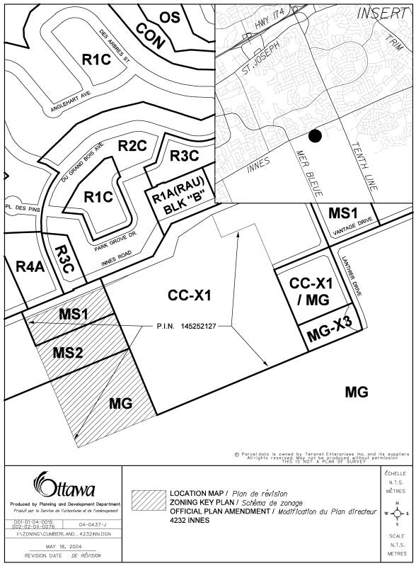
Former City of Cumberland Urban Zoning By-law (1-84)
The former City of Cumberland Zoning By-law designates the northern part of this site "Industrial Service (MS1 & MS2)" and the southern part of the site as "Industrial General - (MG)". The intent of the Industrial Service zone is to permit uses such as an automobile gas bar or service station, automobile repair garage, fitness club, indoor golf establishment, retail warehouse, medical/dental office, and a range of restaurant types. Buildings located within this zone must have a maximum height of 21m and maximum lot coverage of forty percent (40%).
The Industrial General zone permits many of the same uses as the Industrial Service Zone. In addition, this designation allows the following uses: a billiard establishment, equipment rental establishment, lumber yard, mini-warehouse and public storage, and retail or wholesale outlet. The same building provisions described for the Industrial Service designation apply to this zone.
The Department is recommending that the lands be rezoned CC-X5 to be consistent with the nature of the request for an Official Plan Amendment. This acknowledges existing uses and proposed retail/commercial developments approved by the City. Policies for Enterprise and Employment Areas will continue to reflect Council's desire to maintain the supply of lands dedicated to promoting business office, industrial and manufacturing employment in key locations of the city that can support such activity without significant negative impacts residential, commercial and institutional uses within the community.
A Parking Review has been submitted to the City in support of the zoning amendment changes related to parking stalls, loading bays and aisle width.
CONSULTATION
Ward Councillor Rob Jellett was notified and is aware of this application.
APPLICATION PROCESS TIMELINE STATUS
This application was not processed within the timeframe established for the processing of Official Plan and Zoning By-law Amendment applications due to the review of retail policies within Enterprise and Employment Area designations.
SUPPORTING DOCUMENTATION
Document 1 Site Location Map
Document 2 Concept Development Plan ( information purposes only)
Document 3 Proposed Official Plan Amendment
Document 4 Proposed Zoning Amendment
DISPOSITION
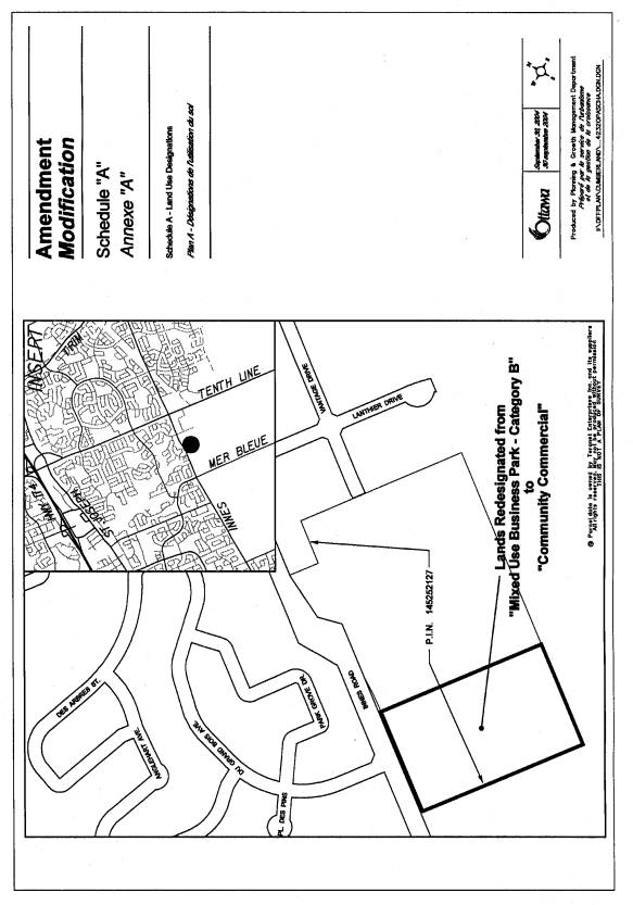
LOCATION MAP Document
1
PROPOSED CONCEPT PLAN Document 2
PROPOSED OFFICIAL PLAN AMENDMENT Document
3
AMENDMENT NUMBER XX
TO THE OFFICIAL PLAN OF THE FORMER CITY OF CUMBERLAND
Part A – The PREAMBLE
The purpose of this amendment is to
redesignate the property from “Mixed Use Business Park – Category B” to
“Community Commercial”.
LOCATION
The lands affected by this amendment are legally described as Part of Lot 1, Concession 2 of the former Geographic Township of Cumberland - Reference Plan 50R-579. The lands are known municipally as 4232 Innes Road and are located on the south side of the Innes Road, west of Lanthier Drive and east of Mer Bleue Road.
BASIS
The proposal to redesignate the subject lands from “Mixed Use Business Park – Category B” to “Community Commercial” to allow the property to be developed for large format retail uses. The proposed land use is consistent with community commercial policies outlined in the Official Plan.
Part B – THE AMENDMENT
1.0 INTRODUCTORY STATEMENT
All of this portion of the document entitled Part B – THE AMENDMENT, and attached map designated Schedule ‘A’ constitutes Amendment Number XX to the Official Plan of the former City of Cumberland.
2.0 DETAILS OF THE AMENDMENT
The Official Plan is amended as follows:
The property fronting on the south side of the Innes Road, to the west of Lanthier Drive, to the north of the Hydro Corridor, and east of Mer Bleue Road, is proposed to be redesignated from “Mixed Use Business Park – Category B” to “Community Commercial” as outlined in Schedule “A” to permit large format retail development.
3.0 IMPLEMENTATION
This amendment shall be implemented by the powers conferred upon the City of Ottawa by The Planning Act, The Municipal Act, or any other statutes which may apply.
4.0. INTERPRETATION
The
provisions of Section 6.9 of the Official Plan shall apply.