Report to/Rapport au :
Planning and Environment Committee
Comité de l'urbanisme et de
l'environnement
and Council / et au Conseil
15 September 2004 / le 15 septembre 2004
Submitted by/Soumis par : Ned
Lathrop, Deputy City Manager / Directeur municipal adjoint
Planning
and Growth Management / Urbanisme et Gestion de la croissance
Contact Person/Personne ressource : Grant Lindsay,
Manager / Gestionnaire
Development Approvals / Approbation des
demandes d'aménagement
(613) 580-2424 x13242, Grant.Lindsay@ottawa.ca
|
SUBJECT: |
ZONING/subdivision - 6851 Flewellyn
Road (Files D02-02-03-0091 and D07-16-03-0024) |
|
|
|
|
OBJET : |
ZONAGE/LOTISSEMENT
- 6851, CHEMIN FLEWELLYN (DOSSIERS D02-02-03-0091 ET D07-16-03-0024) |
REPORT RECOMMENDATION
That the Planning and Environment
Committee recommend that Council refuse:
1. An
application to amend the former Township of Goulbourn Zoning By-law to change
the zoning of 6851 Flewellyn Road from Rural Zone (RU) to Estate Residential
(ER).
2. A draft plan of subdivision on this site.
RECOMMANDATION DU RAPPORT
Que le Comité de l’urbanisme et de l’aménagement
recommande au Conseil de rejeter :
1. une
demande de modification du Règlement de zonage de l’ancien Canton de Goulbourn
en vue de remplacer la désignation de Zone rurale (RU) du 6851, chemin
Flewellyn par la désignation de Zone résidentielle de domaine (ER);
2. un plan de lotissement
préliminaire concernant cet emplacement.
BACKGROUND
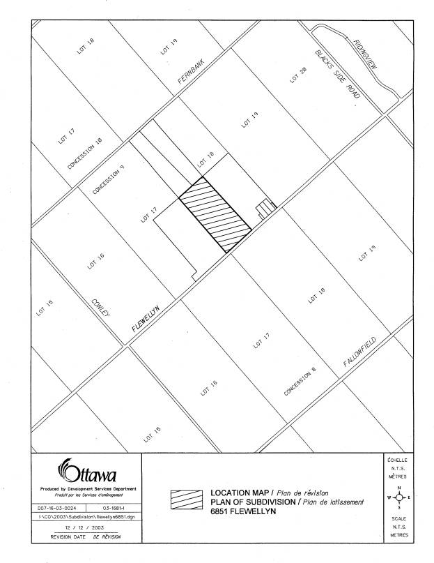
The subject property is located on the north side of
Flewellyn Road approximately 2.5 km west of Huntley Road. The property is zoned Rural (RU) in the
former Township of Goulbourn Comprehensive Zoning By-law 40-99 and currently
does not permit estate lots. The
purpose of the rezoning application is to establish the Estate Residential Zone
(ER) to permit a 23 lot subdivision.
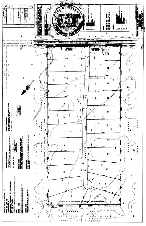
The proposed draft plan of subdivision would create a single access
cul-de-sac with 23, 0.8 hectare lots (see Document 2).
The site is part of the Stittsville West
Natural Area and is characterized as having a flat topography, being wet and
covered with forest. The vegetation is
described as organic swamp communities.
The soil is predominately organic and ranges in depths of 1 to 2 metres.
Prior to the submission of any planning
applications, the applicant constructed a road on the site to allow well
drilling equipment access to conduct the required hydrogeological study. The road was deemed necessary because the
equipment would sink into the thick organic soils. The construction of this road raised concerns with staff and the
environmental community concerning wetland habitat and the hydrologic function
of the site.
The applicant submitted applications for both a
Zoning By-law Amendment and Plan of Subdivision. The applications were circulated to technical agencies and the
public for comment. The Rideau Valley
Conservation Authority (RVCA) and the Ministry of Natural Resources (MNR)
requested that this property and the lands abutting it to the west be evaluated
to determine whether they are Provincially Significant Wetlands. Staff also raised issues about the
suitability of the site for development.
A meeting was held between the applicant and
staff on February 4, 2004 to discuss the issues and the environmental concerns
expressed by the MNR and RVCA. The
applicant was told by the City that funds were available to evaluate the
wetland on his property as part of Flowing Creek Watershed Study. The study is to be completed by late October
2004. The watershed study would also
address concerns raised by the Conceptual Storm Water Management Plan. The applicant was notified that soil testing
would be needed to determine if the sub-soils are capable of carrying the
amount of fill required to develop the site.
It was made clear that the applications would be put “on hold” until the
studies were completed and that information provided supported the proposal.
After the meeting the City was advised by the applicant's lawyer that they do not desire to wait for the findings of the evaluation and that they wanted to proceed with the applications. As of this time the soil test has not been submitted and the City’s biological consultant was not granted access to the site.
DISCUSSION
The application was made on April 23, 2003,
prior to the adoption of the Council Approved Official Plan. The Council Approved Official Plan
designates the property as Rural Natural Features Area and that a satisfactory
Environmental Impact Statement is required.
Due to the date of the application, only the Regional and Local Official
Plan policies pertain to this property. The property is designated as General Rural Area on Schedule A of
the Regional Official Plan and Environmental Feature on Schedule K. Section 5.4.3.2 of the Plan requires all
applications for plans of subdivision to provide an Environmental Impact Statement
when the subject property is designated Environmental Feature. The Environmental Impact Statement needs to
demonstrate that the proposal would have no adverse impact on the natural
features.
The former Township of Goulbourn Official Plan identifies the property
as Marginal Resource. Country Lot
development is a permitted use in these areas subject to the criteria outlined
in Section 7.2.3. One of the primary
criteria are Environmental/Ecological Considerations where it is stated that
county lot development shall not be located on lands having organic soils
whether or not such lands are identified on Schedule ‘B’. Section 10.6 states that Council may approve
development in areas with organic soils if the proponent provides sufficient
soils and engineering information to indicate that the land is suitable or can
be made suitable for the proposed development without causing adverse
environmental effects. At this time the
applicant has not provided soil testing to demonstrate that the sub-soils can
carry the weight of the required fill and the Environmental Impact Statement
does not address what effects removal of the peat will have on the existing
vegetative communities.
Comments were received, as part of the technical circulation, from the
Ministry of Natural Resources (MNR) that these lands were identified for
wetland evaluation. This evaluation was
never conducted at the time other properties were evaluated and classified as
Provincially Significant Wetlands. The
MNR and the Rideau Valley Conservation Authority requested that the applicant
have this property evaluated by a person who is qualified to undertake such a
study.
Staff also raised concerns about the suitability of the site for development. First, the Conceptual Storm Water Management Plan stated that the topography of the site was flat and there was some discrepancy with the size of the drainage area above the site. The concern is that run off from up stream would pool on this site in the drainage ditches and backup drainage from the proposed houses. It would also be difficult to engineer the ditches in order to provide a 0.5% grade from the rear of the property to the front. Second, the Terrain Analysis and Hydrogeological Study detected that most of the site is covered by 1 to 2 metres of organic soils. This would need to be removed and replaced by engineered fill. Staff requested that a geotechnical report be conducted on the sub-soils to determine whether the required fill would be supported.
ENVIRONMENTAL IMPLICATIONS
The subject property is identified as Environmental
Feature on Schedule ‘K’ of the Regional Official Plan. An Environment Impact Statement is required
when developing a country lot subdivision in these areas. The applicant provided an Environment Impact
Statement to support the application, which describes the subject property as
part of the Stittsville West Natural Area.
This area is made of environmentally
significant features including habitat for endangered species and vegetation
communities. The forest on the property
is primarily young to intermediate in age but is predominately wet. The Environment Impact Statement states that
the site is one kilometer from the nearest Provincially Significant
Wetlands. However, the wet forest found
on the subject property extends over onto the abutting properties to within 300
metres of the North Goulbourn Wetland.
This proximity to an already evaluated Provincially Significant Wetland
and the hydrological connection between them, makes it very likely that the wet
forest would be complexed with the North Goulbourn Wetland and this in turn
would change its status to Provincially Significant Wetlands.
The City has undertaken an evaluation of these lands as part of the Flowing Creek Subwater Shed Study. The analysis of the aerial photography identified that most of the lands are wet. An evaluation on the ground has been hampered by the owner’s refusal to permit the biology consultant on the site and the findings of the evaluation will not be available until October. As the evaluation of this property was not completed, staff can not comment on whether there will be any loss of Provincially Significant Wetland. For any development to proceed on the subject lands, this would have to be verified by all the technical agencies and the City. To approve the applicant’s request for a zoning amendment and to consider the draft plan of subdivision to allow for estate lot development is premature. Therefore, staff is recommending refusal of the applications.
RURAL IMPLICATIONS
Staff is unable to determine if the applications
represent appropriate rural development given the absence of the required
information and studies.
CONCLUSIONS
Staff cannot recommend that the applications be
supported. The required studies
submitted by the applicant raised a number of issues that have yet to be
resolved.
The Environmental Impact Statement provided by
the applicant identifies wetland vegetation across most of the property. Given that the wetland is close to other
Provincially Significant Wetlands and the request by both the MNR and RVCA to
evaluate the wetland, staff is not able to determine if this land should be
complexed or if development would mean the loss of Provincially Significant
Wetlands.
The Terrain Analysis and Hydrogeological Study
detected a thick layer (1 to 2 metres) of organic soils over clay. The organic soil will need to be removed and
engineered fill brought in. A soil
study is necessary to determine if the clay subsoil would support the
fill. There may also be significant
impacts to existing vegetation due to extensive removal of peat and placement
of fill.
Staff are concerned that the drainage area
identified in the prepared Conceptual Stormwater Management Plans does not
correspond with the City’s information for this area. This may increase the amount of water traveling past this site
and in light of the flat topography and the difficulty in providing sufficient
grading for road side ditches, it may be difficult to drain surface runoff from
the site. Without further information
to be provided by the Sub-watershed Study, staff can not make a determination.
At this time, and for the reasons addressed above, staff is unable to determine if this property is suitable for development and recommends recommend that both applications be refused.
CONSULTATION
Notice of this application was carried out in accordance with the City’s Public Notification and Consultation Policy. Information signs were posted on-site indicating the nature of the application. The Ward Councillor is aware of this application and the staff recommendation.
Comments were received by the public concerning this development prior to applications being made. The construction of the road base on to this property to conduct the Hydrogeological Study removed many trees and loads of fill have been brought on site. During these discussions members of the public informed staff that the property was part of a wetland that has not yet been evaluated and may be part of the North Goulbourn Wetland complex. This was verified when the MNR and RVCA requested that the property be evaluated.
FINANCIAL IMPLICATIONS
APPLICATION PROCESS TIMELINE STATUS
The application was not processed within the
timeframe established for the processing of Zoning By-Law amendments due to the
complexity of the issues associated with the unevaluated wetlands and
engineering concerns.
SUPPORTING DOCUMENTATION
Document 1 - Location
Map
Document 2 - Draft Plan of
Subdivision
DISPOSITION
Department of Corporate Services, Secretariat
Services to notify the owner Flewellyn Land Holdings Inc., Mario Staltari, 4
Eagle Lane, Ottawa, K2E 1B5, applicant Ray Essiambre, 14 Abbotsford Road,
Kanata, K2L 1C3, lawyer Janet Bradley, Gowlings, 2600-160 Elgin Street, Ottawa,
K1P 1C3, lawyer Soloway Wright, Douglas Kelly, 900-427 Laurier Avenue, Ottawa,
K1R 7Y2, All Signs, 8692 Russell Road, Navan, ON K4B 1J1, and the Program Manager, Assessment, Department of
Corporate Services of City Council’s decision.
LOCATION MAP Document
1
DRAFT PLAN OF SUBDIVISION Document
2