Report to/Rapport au :
Planning and Environment Committee
Comité de l'urbanisme et de
l'environnement
and Council / et au Conseil
12 August 2004 / le 12 août 2004
Submitted by/Soumis par : Ned Lathrop,
Deputy City Manager / Directeur municipal adjoint
Planning and Growth Management / Urbanisme et
Gestion de la croissance
Contact Person/Personne
ressource : Karen Currie, Manager / Gestionnaire
Development Approvals / Approbation des demandes
d'aménagement
(613) 580-2424 x28310, Karen.Currie@ottawa.ca
REPORT RECOMMENDATIONS
That the Planning
and Environment Committee recommend to Council the following:
1. That the Official Plan Amendment
application for 1228 Old Prescott Road/1221 Stagecoach Road and the subdivision
and Zoning By-law amendment applications for 1221 Stagecoach Road to permit the
proposed residential development not be approved at this time;
2. That the City support at the Ontario
Municipal Board hearing, the Zoning By-law amendment for 1228 Old Prescott Road
as shown in Document 3;
3. Approve the presence of staff from the
Corporate Services and Planning and Growth Management Departments at the
Ontario Municipal Board Hearing regarding the applications.
RECOMMANDATIONS DU RAPPORT
Que le Comité de l'urbanisme et de l'environnement recommande au Conseil ce
qui suit :
1. de ne pas approuver pour le
moment la demande de modification au Plan officiel en ce qui a trait au 1228,
chemin Old Prescott et au 1221, chemin Stagecoach ni les demandes de
modification au lotissement et au zonage en ce qui a trait au 1221, chemin Stagecoch
visant à permettre l'aménagement résidentiel
proposé;
2. Que la Ville appuie la
modification au règlement de zonage proposée visant le 1228, chemin Old
Prescott à l'audience de la Commission des affaires municipales de l'Ontario,
comme l'illustre le document 3.
3. d'approuver la présence de
membres du personnel des Services généraux et d'Urbanisme et de Gestion de la
croissance à l'audience de la Commission des affaires municipales de l'Ontario
concernant lesdites demandes.
BACKGROUND
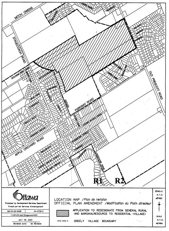
Site Location
The subject
property is located in the centre area of the Village of Greely, however, it is
located outside the village boundary.
The property is located west of Old Prescott Road, north of Parkway
Road, east of Stagecoach Road and south of Mitch Owens Road, as shown in
Document 1. The area is approximately 110 hectares in area and is described as
Part of Lots 3 and 4, Concession 4, former Township of Osgoode. The area is surrounded on three sides by the
village boundary and has thus become known as the "hole in the
doughnut". The property is located
in the Greely West Natural Area which is identified as a Rural Natural Feature. The Natural Environment System Strategy
describes this area as a large wetland and upland forest complex that is rated
as a highly significant natural area in Ottawa. The physical characteristics of
the property are described as containing poplar and white birch upland forest
with a thicket swamp and poplar swamp forest. Soils reports completed for the
area also identify this area as being a discharge area for groundwater, hence
organic soils are also present.
Three
watercourses are present on the
property: the Osgoode Gardens-Cedar Acres Municipal Drain, a tributary of that
drain and the Sunset Lakes Mutual Drain.
In addition to providing fish habitat, the Osgoode Gardens-Cedar Acres
Municipal Drain and the tributary function as the headwaters for Shield's
Creek.
Surrounding
the property to the east and west are existing single family dwellings within
the village, on 0.2 hectare (0.5 acre) lots. To the south east is the Greely
Industrial Park and to the south west is an auto wrecking yard (Spirak's Auto).
To the north, which is located outside the village boundary, is vacant land and
to the north west is the proposed Phase
III expansion to the existing mobile home park by Albion Sun Vista Development
Corporation. An existing hydro transmission
line and two Trans-Northern pipelines bisects the property in the middle from
the north west to the south east. Currently all development within the Village
of Greely and surrounding areas is on the basis on private wells and septic
systems.
Document 2
identifies the individual properties subject to the Official Plan Amendment
application. The applicant owns all of the highlighted properties with the
exception of 1240 Old Prescott Road.
The owner of 1240 Old Prescott Road is aware that the application
includes his lands, but has no comment with respect to the application.
Official Plan
Amendment Application
The former
Regional Official Plan designates the site as General Rural Area on Schedule A
and Environmental Features on Schedule K.
The former Township of Osgoode Official Plan designates the site as
Marginal Resource. These plans are
relevant because they were in effect at the time of the submission of the
Official Plan amendment application which was in March of 2003. Each of the
designations in both plans currently permit country estate lot subdivisions
with minimum lot sizes of 0.4 ha, providing the average lot size is 0.8 ha per lot, when averaged over all the
land in the development.
The City's
new Official Plan designates the area as Rural Natural Features, and requires a
minimum lot size of 0.8 ha. This designation
permits the same uses as permitted in the General Rural Area, providing an
Environmental Impact Statement demonstrates that the proposed development can
occur with no adverse impact on the significant ecological features and
functions in the area. The new Plan
also states new country estate subdivisions may not be located within 1.0
kilometer of a Village boundary, but given that the application was submitted
prior to the approval of the Plan by City Council, the policy is not being
applied in this situation.
The applicant
is proposing to redesignate the site to Village in the former Regional Official
Plan and to Residential in the former Township of Osgoode Plan.
This will bring the lands into the Village and thus permit a more dense
residential subdivision development. Minimum lot sizes permitted within the
requested designations is 0.2 ha.
The applicant
has appealed the subject application to the Ontario Municipal Board on the
basis that City Council had failed to
render a decision on the application within the 90 days of submission. The applicant has also appealed those
policies of the new Official Plan which affect the development of the subject
lands. While the appeal to the new
Official Plan does not form part of this appeal, it is anticipated it will be
the subject of future negotiations and an Ontario Municipal Board hearing.
Subdivision
and Zoning By-law Amendment Applications
The applicant
also submitted subdivision and Zoning By-law amendment applications for the
west portion of the property known as Woodstream Phase 2 and 3, which were
deemed complete in July of 2003. This
area is shown on Document 2 as 1221 and 1165 Stagecoach Road. The subdivision application proposed the
development of approximately 58 country estate lots with a minimum lot size of
0.4 ha, but with an average lot size of 0.8 ha as permitted under the current
designations. A Zoning By-law amendment
application was also submitted which proposed that the land be rezoned from
Rural and Hazard to Country Estate-Exception. The applicant has also appealed
these applications to the Ontario Municipal Board on the basis that City
Council had failed to render a decision within 90 days of submission.
The applicant
has also submitted subdivision and Zoning By-law amendment applications for the
east half of the property which is subject to the Official Plan Amendment application. The property is known as the South 59 or
South Village subdivision and is identified on Document 2 as 1228 Old Prescott
Road. The subdivision application was originally submitted in May of 2002 and
given draft approval in December 2003.
The draft approved plan consists of 59 country estate lots, each a
minimum of 0.4 ha, but again with an average lot size of 2 acres. An appeal was submitted from an adjacent
landowner, but it was subsequently withdrawn.
Staff is prepared to recommend approval of the associated rezoning
application for this draft approved plan of subdivision. Through the processing
of the applications, the applicant advised that he ultimately was proposing to
develop these lands on 0.2 ha lot size basis and was intending to make an
Official Plan Amendment application to that effect. It is this proposal that
staff cannot support at this time. It should be noted that the applicant has
requested the Ontario Municipal Board to consolidate all of the subdivision and
Zoning By-law Amendment applications and appeals, along with the appeal of
Official Plan Amendment application, so that all of the applications are before
the Board.
DISCUSSION
Official Plan
Amendment
It is staff's
position that it is premature to render
a decision on the Official Plan amendment application to redesignate the lands,
bringing them into the Village, until such time that the applicant provides all
required studies and information to support the proposed redesignation. Policies in both the former Regional Plan
and new Official Plan stipulate studies that must be submitted when considering
amendments to expand the boundaries of a Village. Two important studies which have not yet been submitted and
approved are a servicing study (Hydrogeological and Terrain Analysis) and an
Environmental Impact Statement. As late
as August 5, 2004, a Hydrogeological and Terrain Analysis report (dated July
29, 2004) was submitted in support of the Official Plan Amendment
application. The process for reviewing
such reports for sufficiency takes approximately two to four months and
requires the services and approval of the relevant Conservation Authority.
Hydrogeological
and Terrain Analysis Report
A
Hydrogeological and Terrain Analysis Report must demonstrate that the site can
support the proposed development of 0.2 ha lots on the basis of individual
private wells and septic systems.
Evidence must be provided which ensures sufficient quantity and quality
of groundwater exists on the site and the operation of on-site sewage disposal
systems will not adversely impact on wells to be constructed on the proposed
lot(s) and on neighbouring properties.
The applicant has submitted separate Hydrogeological reports for
subdivision applications proposed in the same area, but they were completed on
the basis of having lot sizes of 0.4 ha.
A Hydrogeological and Terrain Analysis Report must be submitted which
consolidates the previous reports into one report and is completed on the basis
of a proposed development containing lots which are 0.2 ha in size.
Technical
comments stress the importance of thoroughly demonstrating in the
Hydrogeological and Terrain Analysis Report that the proposed development can
be supported. The presence of organic
soils in combination with other factors, such as environmental, drainage and
hydrogeological issues, stem from the fact that this is a discharge area for
groundwater, hence the organic soils.
The contour of the "hole in the doughnut" follows the location
of certain soil types in which future development is not recommended, according
to two Water and Earth Science Associates Ltd. reports which discuss this area
(1984 and 1991). Furthermore, the City
commissioned a sampling study in 2002 and a groundwater model in 2003 for the
entire Greely area which identified that with increased development there may
be an increase in nitrate levels in the groundwater in some areas. This implies that increasing the density of
development may also increase the potential risk to the aquifer.
Alternative
Locations/Environmental Impact Statement (EIS)
Section
3.7.4.7 of the former Regional Plan and Section 2.2.2(1a), Village Boundaries,
of City's new Official Plan, outlines
policies addressing development in General Rural Areas and village expansions
and states that Council shall consider the impact of the expansion on various
resources, one being environmental areas designated in the Plan. Section
3.7.4.7 of the former Plan states that Council shall "ensure that
residential and non-residential development in General Rural Areas does not
occur on land unsuitable for development, taking into account such things as
potential hazards to development, aquifer recharge areas, wildlife habitat,
important natural landforms, and quality and quantity of
groundwater." The new Official
Plan goes on to state that where a Village designation is considered, evidence
must be provided that there are no reasonable alternative locations that avoid
these designations. There has been no
evidence provided to staff in terms of reasonable alternative locations that
avoid this environmental designation.
The
property's designation as a Rural Natural Feature Area, triggers the need for
an Environmental Impact Statement (EIS).
Two EIS(s) have been prepared, one on the basis of a proposed
development of 0.5 acre lots (October 2001) and the second for the Woodstream
subdivision application which is on the basis of having one acre lots (July
2003). Environmental staff advises that
both EISs do not accurately reflect existing conditions and they do not
adequately assess the development impacts on the significant environmental features
and functions of the site which include:
interior forest habitat, fish habitat, water quality, thermal regime,
headwater area, ecological corridor function, flood line delineation and creek
buffer. Furthermore, the July 2003 EIS
has deficiencies in supporting 0.4 ha lots, which will make it even more
challenging to support 0.2 ha lots in the area.
Additional
Information
In assessing
any expansion to a village area, it is important that a comprehensive
evaluation of all the lands in the area (not just what the applicant owns) be
undertaken. A development concept which would include such elements as land use
patterns, road and pathway connections and park locations and sizes, should be
prepared. A concept plan for the entire "hole in the doughnut" area
which would show not only the applicant's lands, but how all the lands could be
developed and incorporated into the Village of Greely, is required. The applicant did provide a preliminary
concept plan for a portion of the area, but it lacked detail and there was an
unwillingness on the part of the applicant to collaborate with the other
landowners in the area to produce a concept plan that was representative of all
the developments proposed for the area. Furthermore, a detailed concept plan of
the subject lands illustrating the proposed development including possible
forested areas that could be retained, should the Official Plan Amendment be
approved, was requested, but has not yet been submitted.
Woodstream
(1221 Stagecoach Road) Subdivision and Zoning By-law Amendment Applications
It is also
staff's position that it is premature to move forward with a decision with
respect to the Woodstream subdivision and Zoning By-law Amendment applications
until revised reports and supplementary information is provided.
In March
2003, one month prior to the submission of the Official Plan Amendment
application, subdivision and Zoning By-law Amendment applications were received for the west half of the area which
is the subject of the Official Plan Amendment application. The subdivision, referred to as Woodstream
Phase 2 and 3, proposed a country estate lot subdivision with a minimum lot
size of 0.4 ha, but with an average lot size of 0.8 ha. Approximately one month
later, the applicant requested that the applications be revised to increase the
subject area as he had recently purchased additional land in the area The application was put on hold as the
required supporting studies and information had to be revised to reflect the
increased area. The subdivision
application was put on circulation in August of 2003, following receipt of
revised reports. The Zoning By-law Amendment application was not put on
circulation because it was felt premature to make a decision on the proposed
zoning until the subdivision application had been dealt with and given draft
approval.
Drain
Realignment
Following the
circulation, comments were received from the South Nation Conservation
Authority and other City Departments indicating that additional information and
completion of a satisfactory EIS was required in order to assess the
application. Additional
information requested was the
confirmation/resolution of the applicant's request to the Department of
Fisheries and Oceans(DFO) to realign the Osgoode Municipal Drain. Development
which involves a relocation of a watercourse,
containing fish habitat, requires authorization from the DFO. Staff had received indications from DFO that
they were not prepared to approve the majority of the requested realignment. Staff advised the applicant that the draft
plan of subdivision would have to be revised to redesign the layout of the
roads and lots in respect of the Drain and an appropriate setback. In doing so, the Hydrogeological and Terrain
Analysis Report would also have to be revised to reflect the revised lot
layout. The applicant indicated no
willingness to complete these revisions.
Environmental
Impact Statement
As discussed
earlier in the section on the Official Plan Amendment application, significant
environmental features exist in the area.
The recently completed Shield's Creek Subwatershed Study, which includes
the subject lands, identified the area as containing "significant
ecological features and functions", deserving of a high degree of
ecological protection. Conservation
Authority staff have indicated that to locate a subdivision within this natural
area will have extensive impacts on these functions. Staff from both the Conservation Authority and the City,
Environmental staff, do not support the EIS submitted by the applicant. The EIS
must adequately and confidently demonstrate "no negative impacts on
ecological features and function", prior to development of this area. Thus
it is premature to provide detailed comments on the plan of subdivision until
an EIS, that thoroughly meets this requirement, is provided.
Further, a
site visit was conducted on July 14, 2004 by City staff in the company of developer's staff and environmental
consultant. Much to staff's surprise, a
number of site clearing and preparation activities have taken place on the site
including construction of a new channel based on the assumption that approval
for realignment for the Osgoode Garden Municipal Drain be granted from DFO,
site clearing to accommodate proposed roads, and the digging of a man-made
lake. The development application is
still under review and, as such, all these activities were undertaken with no
approval being granted. It should be
noted that the creation of the lake has removed the interior forest habitat,
the most significant environmental feature on the site. This unauthorized tree cutting is also not
acceptable, again undertaken prior to any approval being granted.
South 59
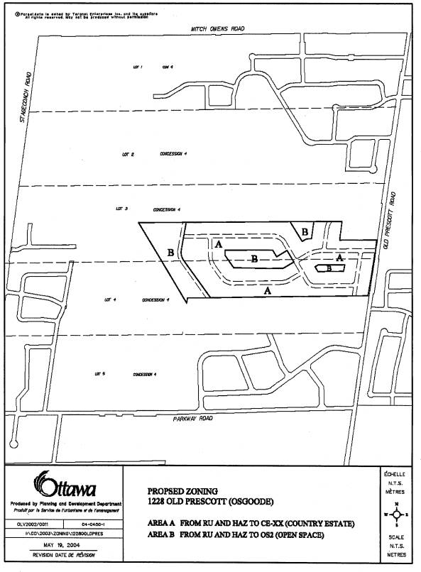
(1228 Old Prescott Road) Subdivision and Zoning By-law Amendment Applications
Staff
continues to support the draft approval for the South 59 subdivision and are
prepared to recommend the adoption of a Zoning By-law Amendment, details of
which are shown in Document 3, to rezone the land to CE-XX(Country
Estate-Exception) and OS (Open Space) to permit a subdivision development with
a minimum lot size of 0.4 ha, but with an average lot size of 0.8 ha. However,
as mentioned, staff are not prepared to support the 0.2 ha lot size for these
lands for reasons previously stated.
Summary
Staff cannot
support the Official Plan Amendment, subdivision and Zoning By-law Amendment
applications, with the exception of the South 59 on 0.4 ha lots at this time,
as the applicant has not submitted sufficient information and studies which
support the proposed development. Staff have requested information regarding,
among other things, site serviceability studies and revised environmental
impact information, none of which have been provided, except for the July 29,
2004 report. On the surface, and in the
absence of any supporting information, the proposed redesignation of the
subject land from General Rural and Marginal Resource to Village, raises
serious concerns. Similarly, the
approval of the Woodstream subdivision and zoning amendment applications,
proposing even larger lots, also raises
concern. In reviewing the relevant
issues and concerns the proposals raise, as they relate to: a safe and continual supply of drinking water, the safe operation
of sewage disposal systems, protection of significant environmental features,
and a comprehensively planned area for the interior area of the Village of
Greely, these strongly indicate that all information must be available prior to
making any decisions with respect to
these important lands.
Ontario
Municipal Board Appeal
The applicant
filed an appeal with the Ontario Municipal Board under Section 22(7), 34(11)
and 51(34) of the Planning Act which are appeals all relating to a Council's
failure to adopt a decision with respect to the subject applications. The
matter is to go before the Ontario Municipal Board on August 25, 2004. Staff is requesting approval from Committee
and Council to represent the City's position, as per this report, at the
Ontario Municipal Board hearing.
ENVIRONMENTAL IMPLICATIONS
As the subject area contains significant environmental features, the completion of a satisfactory Environmental Impact Statement is crucial in order to adequately assess the applications. The environmental issues are discussed in the main portion of the report.
CONSULTATION
Notice of this application was carried out in accordance with the City's Public Notification and Consultation Policy. Information signs were posted on-site indicating the nature of the application. The Ward Councillor is aware of this application.
Comments received from the technical agencies have been noted in the Discussion section of the report. One phone call was received from an individual who is proposing to move to Greely and said they did not support the Official Plan Amendment because she did not want to see smaller lots.
FINANCIAL IMPLICATIONS
Funds are available, for Planning
and Growth Management staff to attend, in the 2004 Operating Budget, Cost
Centre 112762-502119, Directors Office PIA - Business Travel.
APPLICATION PROCESS TIMELINE STATUS
This application was not processed within the timeframe established for the processing of Official Plan Amendments due to the complexity of the issues and insufficient information.
SUPPORTING DOCUMENTATION
Document 1 - Location Map
Document 2 - Ownership
Document 3 - Details of Recommended Zoning (South 59)
DISPOSITION
Department of Corporate Services, Secretariat Services to notify the owner (Daniel Anderson, Sunset Lakes Development Corporation, 2663 Innes Road, Ottawa, ON K1B 3J7
LOCATION MAP Document
1
PROPOSED OFFICIAL PLAN AMENDMENT Document 2