Report to/Rapport au :
Planning and Environment Committee
Comité de l'urbanisme et de
l'environnement
and Council / et au Conseil
28 April 2005 / le 28 avril 2005
Submitted by/Soumis par : Ned Lathrop, Deputy City Manager/Directeur
municipal adjoint,
Planning and Growth Management/Urbanisme et Gestion de la croissance
Contact
Person/Personne ressource : Grant Lindsay, Manager / Gestionnaire
Planning and Infrastructure
Approvals/Approbation des demandes d’aménagement et d’infrastructure
(613) 580-2424 x13242, Grant.Lindsay@ottawa.ca
|
SUBJECT: |
|
|
|
|
|
OBJET : |
REPORT RECOMMENDATION
That the Planning and Development Committee recommend Council approve an amendment to the former City of Nepean Urban Area Zoning By-law 100-2000, to change the zoning of 20 Farlane Boulevard from an Institutional Zone to an R5B - Residential Fifth "B" Density Zone with Exceptions, as detailed in Document 2 and as shown on Document 3.
RECOMMANDATION DU
RAPPORT
Que le Comité de l’urbanisme et de
l’environnement recommande au Conseil d’approuver une modification au Règlement
de zonage urbain 100-2000 de l’ancienne Ville de Nepean en vue de modifier le
zonage du 20, boulevard Farlane de zone institutionnelle à R5B - zone
résidentielle de densité « B » cinq
assortie d’exceptions, comme il est détaillé dans le document 2 et indiqué dans
le document 3.
BACKGROUND
The subject property, 20 Farlane Boulevard, is located on the west side of Farlane Boulevard and south of Baseline Road and is part of a larger property known municipally as 1026 Baseline Road that is owned and occupied by Villa Marconi Long Term Care facility. A Consent for Severance application was approved by the Committee of Adjustment on April 12, 2005 pending a 20-day appeal period to allow for the sale to the applicant of the subject property which is vacant and surplus to the needs of the Long Term Care facility. The lands surrounding the site to the south, east, and west contain a mix of low-profile residential dwellings.
The applicant is requesting permission to amend the site’s current zoning designation to permit the development of 50 dwelling units (25 semi-detached). To facilitate this, the applicant is requesting to rezone the site from I – Institutional to R5B – Residential Fifth "B" Density Zone with some exceptions. The proposed exceptions would establish increased required yard setbacks, and would permit a maximum of 50 dwelling units for the subject lands.
DISCUSSION
The property is designated
Residential in the former City of Nepean Official Plan, and General Urban Area
in both the former Regional, and City Council Approved Official Plans. All three of these plans permit residential
intensification.
CITY COUNCIL APPROVED OFFICIAL PLAN
The City Council Approved Official Plan
designates the land as "General Urban Area". Section 2.2.3 Managing Growth Within the
Urban Area states "The projected urban population and associated land
required for housing and jobs can be accommodated within the existing urban
area provided: Development in greenfields occurs at densities somewhat higher
than densities achieved in greenfields in the past and land uses intensify
within existing areas of development. Intensification means the density
of development, measured in households or employment per hectare,
increases. Intensification occurs along a continuum, from expansion of an
existing use or infill on a vacant lot, right up to large - scale redevelopment
of an areas such as Rockcliffe Airbase."
Section 2.2.3 (1.) states that "Within the General Urban Area,
opportunities for intensification exist and will be supported. Where a zoning by-law amendment is required,
the appropriateness of the scale of development will be evaluated along with
the design and its compatibility."
Section 2.2.3 (3.) states that "The City supports intensification and
infill development throughout the urban area, including areas designated
General Urban Area. The City will promote opportunities for
intensification and infill in the following cases, provided that all other
policies in the Plan are met...c) Lands where the present use is
maintained but the addition of residential uses or other uses can be
accomplished in a complementary manner, such as on under-utilized shopping
centre sites."
Section 2.5.1 provides guidance on the Compatibility of Development.
Paragraph one indicates that "introducing new development in existing
areas that have developed over a long period of time requires a sensitive
approach to differences between the new development and the established area,
in terms of building heights, setbacks, and other characteristics.
Compatibility of Proposal
The proposed
development represents an appropriate location for infill development. It
is to be located on an underutilized portion of the Villa Marconi Long Term
Health Care facility lands. The access to the developments’ private road
will be from Farlane Boulevard, a designated collector road in the City Council
Approved Official Plan. The traffic assessment has indicated
that the proposed development would have a minor impact on the existing
operation of traffic along Farlane Boulevard and would result in little traffic
cutting through the community as the majority of traffic would head north along
Farlane Boulevard to Baseline Road. The
site is located within walking distance to bus service on Baseline Road,
approximately 200 metres to the north.
The development can be serviced with existing sanitary, water and storm sewers
providing servicing efficiencies to the City. The proposal for stormwater
management will improve the existing situation for the Fisher Heights area
which has experienced flooding issues during major rainstorm events. The
applicant is proposing to redirect all stormwater from the proposed site, as
well as from the remainder of the Villa Marconi property and the property
located to the west of the Villa Marconi site. The stormwater from these
sites currently drains towards the storm sewer under Farlane Boulevard
producing approximately 400 L/s of storm flow during a five year storm
event. As part of the servicing of the proposed development this
stormwater will be redirected to the storm sewers on Baseline Road which has
capacity and has no connection to the Fisher Heights system along Farlane
Boulevard. This will, therefore, improve the situation for the Fisher
Heights storm sewer system.
Densities are higher than along the streets of the existing adjacent homes, but
the site has been designed so that it is compatible with the existing
homes. The proposed homes will be two-storeys in height or 9.2
metres. This is compatible with the
existing one- and two-storey homes immediately adjacent to the site. The
existing homes on Eleanor Drive are zoned R2 and on the east side of Farlane
Boulevard are zoned R3. Both zones allow a 9.2 metre maximum building
height. Adjacent to the west is a
higher density development comprising of multiple attached bungalow dwellings
on private road. The zoning for these
properties is R5A – Residential Fifth Density Zone.
In summary, the use proposed, the building height, building mass, setbacks
between buildings and rear yard setbacks all contribute to making this a
compatible infill project. Density increases are moderate, servicing
efficiencies and improvements will be realized, and the traffic impacts are to
be minor. Approval of this application to allow a
more intense form of residential development is in keeping with the intent of
the City Council Approved Official Plan.
FORMER REGIONAL OFFICIAL PLAN POLICIES
The Official Plan of the former Region contains a development strategy for residential intensification. As stated in the Official Plan, this strategy is intended to encourage denser, compact and more balanced development on land designated for urban purposes. This policy was established to achieve objectives related to reducing the dependence on the automobile, providing more efficient use of existing land, facilities and services as well as supporting and encouraging economic development.
Compatibility of Proposal
This infill residential project is located at the edge of a residential neighbourhood on a collector road. There is close access to the bus stop at Baseline and Farlane - approximately 200 metres away. The Nepean Zoning By-law requires that one parking space be provided per semi-detached dwelling. Two parking spaces will be provided per unit (garage and driveway) in addition to eight visitor parking spaces (visitor parking not required but to be provided). A traffic assessment was completed which indicted that the proposed development would have a minor impact on the operation of traffic along Farlane Boulevard and the other local roads. The development would result in little traffic using the neighbourhood streets as the majority of traffic would head north along Farlane Boulevard to Baseline Road (arterial). The proposed two-storey semi-detached residential units are compatible with the adjacent existing one- and two-storey single detached homes and bungalow style townhouses. Alternative development standards are proposed for the site with the use of a private road to serve the development.
Approval of this application to allow a more intense form of residential development is in keeping with the intent of the former Regional Official Plan.
FORMER CITY OF NEPEAN OFFICIAL PLAN
The Official Plan of the former City of Nepean designates the subject lands as "Residential". Section 2.0 (b) states "On Map Schedule 1, areas which are to be predominately used for residential purposes have been designated "Residential" and further in subsection 2.0 (b) (III) it states "Notwithstanding the policies of Sections 2.1 and 2.2, Council recognizes that higher density residential, institutional, local shopping, local office and service uses may be appropriately located outside the core area of the neighbourhood Community. In such cases, Council shall encourage these uses to be located along a collector or arterial roadway and shall ensure that the development harmonizes with and has an appropriate relationship to neighbouring development."
Compatibility
of Proposal
Two storey semi-detached residential uses are proposed for this development. The development will access on to Farlane Boulevard, which is designated a Collector Road, in the Nepean Official Plan. The use and height of the proposed homes is in scale with the existing homes in the area. The relationship to the neighbouring development has been considered. A rear yard setback of 7.5 metres is provided adjacent to the rear yards of the existing homes located along Eleanor Drive and Briardale Crescent. Privacy will be maintained in the rear yards with cedar hedging and planting of deciduous trees. Eight homes will front along Farlane Boulevard, as opposed to backing onto the street, to enhance the Farlane Boulevard streetscape. Approval of this application to allow a more intense form of residential development is in keeping with the intent of the former City of Nepean Official Plan.
Details of Proposed Zoning
A rear yard
setback of 7.5 metres is proposed adjacent to the existing homes on Eleanor
Drive and Briardale Crescent, whereas 6.0 metres has been proposed elsewhere on
the site. The side yard setbacks or building separation between the
semi-detached homes is similar to the side yard requirements of the adjacent
homes. The R2 zone for the homes on Eleanor Drive permit side yards of
0.9 metres on 1 side and a 1.5 metre side yard on the other side, for a total
of 2.4 metres. The R3 zone for the homes along the east side of Farlane
Boulevard permit 0.9 metres and 1.2 metres for a total of 2.1 metres. The
proposed development will provide 1.2 metres on each side for a total of 2.4
metres of side yards.
The building width will also be
compatible, if not smaller, than permitted in the zoning of the existing homes
on Farlane and Eleanor Drive. The proposed semi-detached homes will be
6.0 metres in width for each dwelling unit or 12.0 metres for each block of two
homes. The homes along Eleanor Drive and Farlane Boulevard are zoned to
allow a maximum building width of 17.4 metres.
CONSULTATION
The public was consulted by the posting notification signs on the subject property and by the mailing of notices to community organizations serving the area. As well, two public meetings were held by the applicant to discuss the proposal with the community. There were four responses to the notification, which are described and addressed in Document 5.
The Ward Councillor is aware of this application and the staff recommendation.
FINANCIAL IMPLICATIONS
N/A
APPLICATION PROCESS TIMELINE STATUS
This application was processed within the
“On Time Decision Date” established for Zoning By-law Amendments.
SUPPORTING DOCUMENTATION
Document 1 Explanatory Note
Document 2 Details of Proposed Zoning
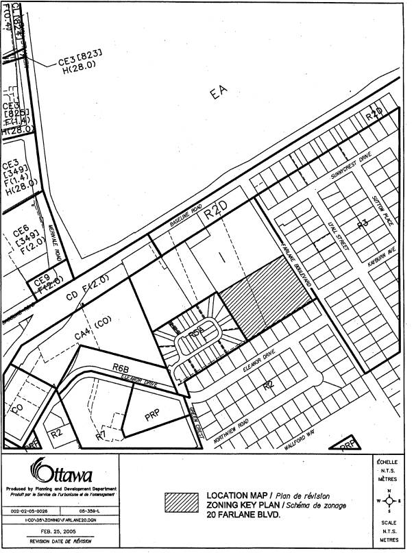
Document 3 Location Plan
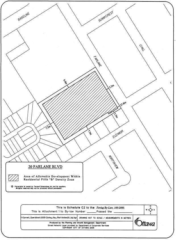
Document 4 Schedule C2
Document 5 Consultation Details
DISPOSITION
Department of Corporate Services, Secretariat Services to notify the agent (Debbie Belfie, 21 Pinecone Trail, Stittsville, Ontario, K2S 1E1) of Council’s Decision.
Legal Services to forward the implementing by-law to City Council.
Planning and Growth Management Department to prepare the implementing by-law, forward to Legal Service Branch and undertake the statutory notification and the Program Manager, Assessment, corporate Services Department of City Council’s decision.
EXPLANATORY NOTE Document 1
THE FOLLOWING IS AN EXPLANATORY NOTE TO BY-LAW NUMBER
By-law Number ……… amends By-law Number, 100-2000, the former City of Nepean’s Comprehensive Zoning By-law. This amendment affects the lands located at the rear of the Villa Marconi site (1026 Baseline Road) on the southwest corner of Baseline Road and Farlane Boulevard. This parcel of land is known municipally as 20 Farlane Boulevard is vacant and has been deemed surplus to the needs of the Villa Marconi retirement home. It is proposed to sever the lands from the Villa Marconi site and rezone the property to permit the development of 50 dwelling units (25 semi-detached houses) on private road. The extent of the lands can be seen on Document 2.
Current Zoning
The subject property is currently zoned Institutional - I. This zoning allows a limited number of uses, such as a cemetery, day nursery, funeral parlour, long term care facility, place of assembly, place of worship, private club, respite care facility, retirement home and private school. The allowable lot coverage by the buildings on the property is 40%, while the height limit is 24.4 metres. All of the yard setbacks are a minimum of 6.0 metres.
Proposed Zoning
The proposed zoning is Residential Fifth “B” Density – R5B Exception Zone. This is a zoning that allows detached and multiple attached dwellings. The allowable lot coverage by the buildings on the property is 40%, while the height limit is 10.7 metres. A density of 40 dwelling units per hectare is permitted. The minimum front and rear yard setback is 6.0 metres and the side yard setback is 6.0 metres with a main building spacing of 3.0 metres. The exceptions are the following: consider the newly severed lands as one lot for the purposes of determining zoning requirements; permit semi-detached dwelling as a use; allow a maximum of 50 dwelling units; allow main building spacing of 2.4 metres; establish increased rear yard setback from 6.0 metres to 7.5 metres; allow reduced front yard setback of 5.2 metres; allow reduced side yard setback of 3.5 metres for a length of 27.8 metres along the south property line; allow parking space length of 5.2 metres and width of 2.6 metres; allow visitor parking space length of 5.2 metres and width of 2.6 metres; and change the lot frontage requirement from a minimum of 30.0 metres to an overall lot frontage requirement of 97.0 metres minimum.
DETAILS OF PROPOSED ZONING Document 2
The property as shown in Document 3 will be rezoned from I to R5B Block __ including the following zone requirement exceptions:
1. notwithstanding Subsection 5:9 & 5:10, the land zoned R5B Block __ is considered one lot for the purposes of determining zoning requirements despite the lawful severance of a lot pursuant to the Planning Act or the Condominium Act.
2. yard setbacks are determined as per Schedule C2 (see Document 4).
3. Maximum allowable dwelling units of 50.
4. lot frontage requirement changed from 30.0 metres minimum to an overall lot frontage requirement of 97.0 metres minimum.
5. Uses permitted: semi-detached.
6. Main building spacing of 2.4 metres
7. notwithstanding Subsection 5:20:2(iv), parking spaces shall have a minimum width of 2.6 metres and a minimum length of 5.2 metres.
8. notwithstanding that the lands zoned R5B Block __ are considered as one Lot for zoning purposes, the provisions of Subsection 5:18 shall apply to each dwelling unit and its associated lands with all necessary modifications.
9. notwithstanding Subsection 5:20:2 (ii) and 5:20:4 (ii), visitor parking shall be permitted in the designated visitor parking area. Parking shall be 2.6 metres in width and 5.2 metres in length.
NOTIFICATION AND PUBLIC CONSULTATION PROCESS
Notification and public consultation procedures were carried out in accordance with the Notification and Consultation Procedures approved by City Council for Zoning By-law Amendments.
PUBLIC COMMENTS
This application was subject to Notification and Consultation, which required the posting of an on-site information sign and circulation to concerned community groups. Four responses in opposition were received from the posting of the on-site sign. A summary of their comments and responses to their comments are presented below. On March 3, 2005 and April 1, 2005, public meetings were held by the developer with the local community. Approximately 30 people attended these meetings. A summary of concerns received from the public meetings and from the posting of the on-site sign and a response to their concerns are presented below.
Councillor’s Comments
Councillor Gord Hunter is aware of the application.
Summary of Concerns and Response
1. The proposed development will result in too much traffic and should necessitate traffic lights at Baseline Road and Farlane Boulevard.
Response
A Traffic Assessment was undertaken by the applicant and accepted by the City. It indicates that the proposed residential development will not have a significant impact on traffic levels on the surrounding streets and intersections. As well, no roadway modifications or traffic lights at Baseline and Farlane are required as a result of this development.
2. The proposed higher density of the development is not compatible with the existing community and bungalows instead of semis should be proposed.
Response
The proposed density increase is moderate and the proposed semi-detached houses will allow a more denser and compact form of residential development that is more in keeping with the intent of the City Council Approved Official Plan policies for residential intensification.
3. This development will result in a loss of my privacy in the rear yards and second floor windows.
Response
As stated in the report, the Department does not believe that the proposed rezoning will result in a development that will create a privacy nuisance to existing residential properties. While it is true that semi-detached dwellings will have a higher level of occupancy than a detached dwelling, it is the Department’s position that the proposed development will have a minimal impact on the privacy of residential dwellings located to the south and west. The rear yard setback will be 7.5 metres as opposed to 6.0 metres for similar developments. Also, the Site Plan Control application will ensure that the proper landscaping achieves privacy for all affected rear yards.
4. This proposal will lower my property value.
Response
The reduction of property values is a common concern with development proposals. This is not a consideration of a rezoning proposal. Further, the Department is not aware of any evidence supporting the proposition that infill development negatively affects property values. The developer intends to build quality homes with attractive landscaping.