Report to/Rapport au :
Planning and Environment Committee
Comité de l'urbanisme et de
l'environnement
and Council / et au Conseil
Submitted by/Soumis par : Ned Lathrop, General Manager/Directeur général,
Development Services/Services
d'aménagement
Contact Person/Personne ressource : Karen Currie,
Manager / Gestionnaire
Development
Approvals / Approbation des demandes d'aménagement
(613)
580-2424 x28310, Karen.Currie@ottawa.ca
|
SUBJECT: |
ZONING
- 1653 MANOTICK STATION ROAD (FILE NO. D02-02-03-0189) |
|
|
|
|
OBJET : |
ZONAGE
- 1653, CHEMIN MANOTICK STATION (NO DE DOSSIER : D02-02-03) |
REPORT RECOMMENDATION
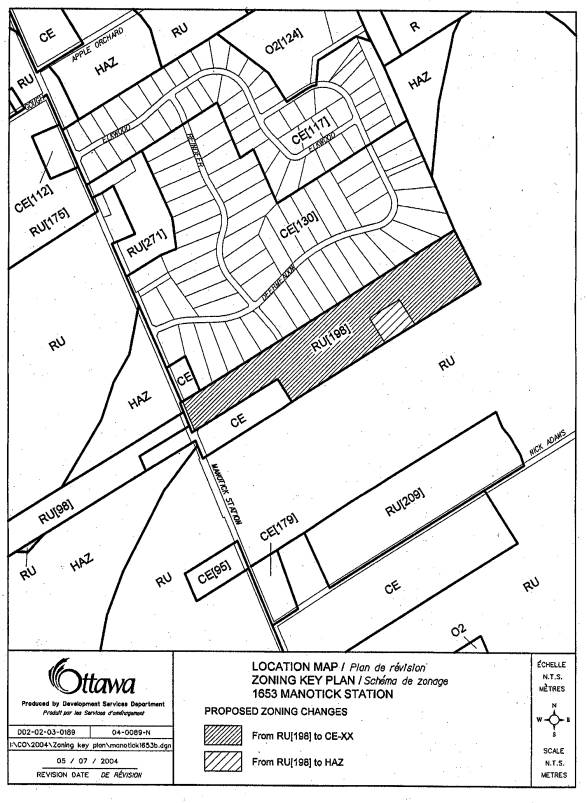
That the Planning and Environment Committee recommend Council approve an amendment to the former Township of Osgoode Zoning By-Law 2003-230 to change the zoning of 1653 Manotick Station Road from Rural Exception (RU-198) to Country Estate - Exception (CE-XX) and Hazard (HAZ) as shown on Documents 1 and 2 and detailed in Document 3.
RECOMMANDATION DU RAPPORT
Que le Comité de l'urbanisme et de l'environnement recommande au Conseil
municipal d'approuver une modification au Règlement de zonage no 230-2003 de
l'ancien Canton d'Osgoode en vue de faire passer le zonage du 1653, chemin
Manotick Station de Zone rurale d'exception (RU-198) à Zone de domaine de
campagne (CE-XX) et à Zone de terres vulnérables (HAZ), comme l'illustrent les
documents 1 et 2 et le précise le document 3.
BACKGROUND
The subject property, 1653 Manotick Station Road, is located in the northwest corner of Concession 3, Lot 9 southeast of the Manotick Station Road and Deermeadow intersection, just outside of the Village of Metcalfe. The site is bounded on the north by an existing residential subdivision, on the west Manotick Station Road, and to the south and east by predominantly undeveloped land with two exceptions to the southwest: a residential property with a small-motor garage and a residential property with stables. The site is bisected (east-west) by Grey's Creek which flows in a south/southwest direction.
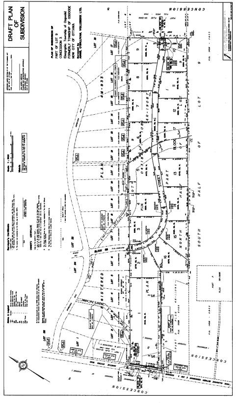
The purpose of the proposed rezoning is to provide appropriate zoning for lands in the draft plan of subdivision to permit single family dwellings to be constructed on 16 Country Estate lots. The rezoning of 1653 Manotick Station Road proposes the following zoning amendments to address the conditions of the draft plan of subdivision:
rezone subject lands from Rural Exception (RU-198) to Country Estate Exception (CE-XX), to include the following provisions:
"no-touch/no-build" setback of 30 metres from the Grey's Creek Municipal Drain, measured shoreward from the edge of the average annual high-water mark;
"no-touch/no build" setback of 15 metres from the Grey's Creek tributary (that extends south between Lots 4 and 5 for approximately 85m from Grey's Creek), measured shoreward from the edge of the average annual high-water mark;
"no-touch/no build" setback of 15 metres (within the existing 23 metre rear yard setback CE Zone requirement) from the rear yards of lots 6, 7, 8 and 9 measured from the northern property lines.
rezone Block 17 as Hazard (HAZ) Zone
DISCUSSION
Both the Council Approved Official Plan and the former Regional Official Plan designate the site as 'General Rural Area' and a portion of the north-west of the site as 'Rural Natural Features' (Schedule A) and as "Organic Soils" (Schedule K).
The former Township of Osgoode Official Plan designates the land as 'Marginal Resource' and 'Environmental Protection (Organic Soils)'.
The development is in conformity with the existing Official Plan policies of both the Regional and Osgoode Official Plans. The designations have policies supporting residential development in the rural area on larger country estate lots provided the development is sensitive to the landscape and the environment. There are 16 lots proposed with minimum frontages of 54 metres and minimum areas of 0.8 hectares.
At least two of the proposed lots are located partially or entirely within the boundaries of the Rural Natural Features designation and much of the site is designated as "Organic Soils" under the Council Approved City of Ottawa Official Plan Environmental Constraints (Schedule K). The applicant has submitted an Environment Impact Statement (EIS) as part of the subdivision application which has concluded that none of the regionally significant features and functions of the Manotick Station South Natural Area are anticipated to be impacted as a result of this proposed development. Impacts to the Manotick Station South Natural Area and the natural environment of the subject property, in general, can be reduced by properly implementing the mitigation measures identified in the EIS report and outlined in the conditions of the draft plan of subdivision.
The Hydrogeological Investigation and Terrain Evaluation report also concluded that groundwater quantities and qualities are sufficient for drinking and that the soils are suitable for sewage disposal and development.
This proposed rezoning is in keeping with the country estate lot development that has occurred over the past years in the rural area of Osgoode and complements the subdivision to the north of the site and responds to the surrounding natural environment. It conforms with the policies of the Official Plan and is considered compatible and desirable development.
ENVIRONMENTAL IMPLICATIONS
Environmental concerns will be addressed by creating a CE Exception Zone that includes setback provisions that are responsive to site specific conditions. A 15 and 30 metre "no touch/no build" setback will be located along the edges of identified watercourses (measured from the high water mark). The intent is to conserve and enhance onsite and downstream environmental features; for example, through protecting onsite existing and planted vegetation and slope stability; maintaining overland flows and linkage between the riparian corridor and the Natural Feature to the east of the property; and, protecting the downstream fish habitat and on-site tributary of Grey's Creek.
CONSULTATION
Notice of this application was carried out in accordance with the City's Public Notification and Consultation Policy. Information signs were posted on-site indicating the nature of the application. The Ward Councillor is aware of this application and the staff recommendation. The City did not receive any negative comments or opposition to this application.
FINANCIAL IMPLICATIONS
N/A
APPLICATION PROCESS TIMELINE STATUS
This application was processed within the timeframe established for the
processing of Zoning By-Law Amendment applications.
SUPPORTING DOCUMENTATION
Document 1 Location Map
Document 2 Draft Plan of Subdivision
Document 3 Details of Recommended Zoning
DISPOSITION
Department of Corporate Services, Secretariat Services to notify the applicant and owner, Dan O'Brien, 6212 Deermeadow Drive, Ottawa, ON, K4P 1M9, All Signs, 8692 Russell Road, Navan, ON K4B 1J1, and the Program Manager, Assessment, Department of Corporate Services of City Council's decision.
Planning and Development Department to prepare the implementing by-law, forward to Legal Services Branch and undertake the statutory notification.
Department of Corporate Services, Legal Services Branch to forward the implementing by-law to City Council.
LOCATION MAP Document
1