Report to/Rapport
au:
Planning and
Development Committee/
Comité de
l’urbanisme et de l’aménagement
and Council/et au Conseil
22 November 2001 /
le 22 novembre 2001
Submitted
by/Soumis par: Ned Lathrop, General Manager/Directeur général
Development Services Department / Services d’aménagement
Contact/Personne-ressource: Grant Lindsay, Manager, Development
Approvals /
Gestionnaire,
Approbation des demandes d’aménagement
244-5300 ext. 1-3242 grant.Lindsay@city.ottawa.on.ca
|
|
|
Ref N°:
ACS2001-DEV-APR-0296 |
SUBJECT: OFFICIAL PLAN AND ZONING BY-LAW APPEAL TO
THE ONTARIO MUNICIPAL BOARD – 2580 WALKLEY ROAD
OBJET: APPEL INTERJETÉ DEVANT LA
COMMISSION DES AFFAIRES MUNICIPALES DE L’ONTARIO CONCERNANT LE PLAN DIRECTEUR
ET LE RÈGLEMENT MUNICIPAL SUR LE ZONAGE – 2580, CHEMIN WALKLEY
REPORT RECOMMENDATIONS
That the Planning and Development Committee recommend that Council:
1. Approve Amendment No. 50 to the
Official Plan of the former City of Ottawa, as it relates to 2580 Walkley Road,
as detailed in Document 2.
2. Approve
an amendment to Zoning By-law, 1998, of the former City of Ottawa, as it
relates to 2580 Walkley Road, as detailed in Document 3.
3. Direct Legal Services and Development Services staff to attend the Ontario Municipal Board Prehearing Conference and Full Hearing concerning an appeal filed by the National Capital Commission against the Official Plan and Zoning Application, of the former City of Ottawa for 2580 Walkley Road, and further, that Council direct staff to support the amendments as recommended by staff.
RECOMMANDATIONS DU RAPPORT
Que le Comité de l’urbanisme et de
l’aménagement recommande au Conseil :
1. D’approuver
la modification no 50 au Plan directeur de l’ancienne Ville d’Ottawa
en ce qui concerne le 2580, chemin Walkley, ainsi qu’il est précisé au document
2.
2. D’approuver une
modification au Règlement municipal sur le zonage de 1998 de l’ancienne Ville
d’Ottawa, en ce qui a trait au 2580, chemin Walkley, ainsi qu’il est précisé au
document 3.
3. De donner instruction au
personnel des Services juridiques et des Services d’aménagement d’assister à la
conférence préparatoire et à l’audience de la Commission des affaires
municipales de l’Ontario concernant un appel interjeté par la Commission de la
capitale nationale relativement à une demande de modification du Plan directeur
et du Règlement municipal sur le zonage de l’ancienne Ville d’Ottawa pour ce
qui a trait au 2580, chemin Walkley; et de donner instruction au personnel
d’appuyer les modifications recommandées par le personnel.
BACKGROUND
In April 2000, applications were
filed on behalf of the National Capital Commission, to amend the former City of
Ottawa Official Plan and Zoning By-law as they apply to a vacant parcel of land
on the southeast corner of Walkley Road and Hawthorne Road. The applications request that the subject
lands Official Plan designation be amended from that of a Traditional Industrial Area and Business
Employment Area to Community Shopping Centre.
Staff have reviewed the applications in detail and on October 31, 2000 forwarded a report to the former City of Ottawa’s Planning and Economic Development Committee recommending refusal of the application as submitted. At the request of the Sheffield Community Association, with the concurrence of the National Capital Commission, this report was deferred to the Council of the new City of Ottawa.
In September 2001, the City
received notice from the Ontario Municipal Board (OMB) that the applicant had
filed a Notice of Appeal in relation to the proposed Official Plan and Zoning
By-law amendment applications. The
appeals were filed with the OMB on the basis that Council had failed to adopt
the requested amendments within 90 days after receipt of the applications. A Prehearing Conference will be held on
December 5 2001, to deal with preliminary and procedural matters. The OMB was advised that staff were in the
process of preparing a report to Planning and Development Committee for a
meeting date of November 22, 2001.
LOCATION
The
subject property fronts onto the south side of Walkley Road and the east side
of Hawthorne Road, and is bound to the south and east by a Canadian National
Railway (CN) line (See Document 1).
Neighbouring development includes the neighbourhoods of Sheffield Glen
and Hawthorne Meadows to the northwest of the site, the Lancaster/Sheffield
industrial park to the north and east, the Ottawa Business Park and a warehouse
distribution centre to the west, and a correctional facility is located to the
south. This property has a land area of
approximately 7.22 hectares which is currently vacant with steep embankments
partially along Hawthorne Road, Walkley Road, and the CN railway corridor.
DISCUSSION
The subject property is surplus Federal land and the National Capital Commission wishes to market and dispose of it for development. The applicant’s submission for Zoning By-law and Official Plan amendments included a Planning Study, a Transportation Analysis, a Development Potential Assessment, an Environmental Assessment and Evaluation, an Archaeological Survey, and a Site Servicing Report. These studies established the viability for the development potential of a commercial shopping centre. To summarize, these studies indicated that a commercial shopping centre development would not negatively impact on area retail centres, the inventory of industrial lands, place an onerous burden on the existing transportation infrastructure, nor have a negative environmental impact.
OFFICIAL PLAN
The
subject site forms part of a larger area designation in the Official Plan as
Traditional Industrial and Business Employment lands. This area includes lands located in proximity to Industrial and
Belfast Avenues, extending southeasterly to Ridge Road, then southerly along
Hawthorne Road and westerly to encompass the Ottawa Business Park. The subject lands are centrally located in
the southerly quadrant of these described industrial and business employment
lands and are central to what forms a transportation hub for these land
uses. The construction of the Walkley
Road/Highway 417 interchange, and the realignment of Hawthorne Road, together
with proximity to existing regional arterial roadways, including Walkley Road,
Russell Road, Hawthorne Road and St. Laurent Boulevard, provides these industrial/business
employment lands with good access to several major transportation corridors.
In consideration of any change in an Official Plan Designation, Official Plan Objective 4.5.1 directs the preservation of industrial/business employment areas for future growth, and the control of non-industrial uses. Staff did recognize that a Traditional Industrial designation was no longer appropriate for the site. However, staff was concerned with a Community Shopping centre designation as it was thought office uses also should be established on the site. A mix of commercial and office uses, in the Department’s opinion, would result in more compatible development to the neighbouring residential development on the north side of Walkley Road while allowing for an increase in development potential.
In subsequent discussions with the National Capital Commission, an understanding was reached that a development proposal which included both retail and commercial office could be supported by both parties. The office use maintains a business employment component to the site which is consistent with neighbouring development on north side of Walkley Road where intersected by Lancaster Road. In order to maintain the commercial viability of the site and to stay within the acceptable limits of development potential for this site based on a traffic study submission, an agreement was reached that a 60/40 split of retail and office development would be an appropriate development for this site. Details of the Official Plan Amendment have been attached as Document2.
ZONING BY-LAW
Staff are recommending that the lands be rezoned to CS1, Community Shopping Centre, with an exception and followed by a schedule. The purpose of introducing an exception to the zoning is as follows:
· To introduce a business employment component to the site development;
· To ensure that business employment uses are introduced to the site development after a set limit of commercial retail build-out has occurred;
· That the building heights of this development do not negatively impact onto adjacent residential development;
· That restaurant operations do not negatively impact onto adjacent residential development; and
· That there is a minimum building setback from the Canadian National Rail Line is provided.
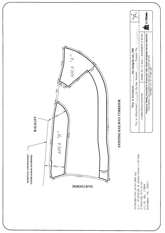
The schedule for this Zoning By-law amendment implements the performance standards setout by the exception. Details of the zoning has been attached as Document 3.
CONSULTATION
The Canterbury and Sheffield Glen Community Associations have been notified of hearing date for the OMB appeal together with the owner and tenants within 120 metres of this property.
Councillor Diane Deans has been made aware of this report.
FINANCIAL IMPLICATIONS
The City would be represented at the OMB Prehearing Conference and Hearing by a City Solicitor and a planner from the Development Services Department at no additional cost to the City.
ATTACHMENTS
Document 1 Location Map
Document 2 Official Plan Amendment
Document 3 Zoning Details
DISPOSITION
Development Services and Legal Services will prepare the appropriate document package to be forwarded to the OMB advising of Council’s decisions on the amendments prior to the 5 December 2001 Prehearing Conference.
Location Map Document 1
Official Plan Amendment Document 2
BY-LAW NO. 2001 –
A by-law of the City of Ottawa to amend the Official Plan of the old Corporation of the City of Ottawa.
WHEREAS the Ontario Municipal Board pursuant to subsection 17(50) of the Planning Act, RSO 1990, c. P. 13, as amended, has approved Official Plan Amendment No.__ ;
THEREFORE the Ontario Municipal Board orders as follows:
1. The attached text and maps, which constitute Amendment No. __ to the Official Plan of the Planning Area of the former Corporation of the City of Ottawa, is hereby adopted.
2. This by-law shall come into force in accordance with the provisions of the Planning Act, RSO 1990, c. P. 13, as amended.
ORDERED this __ day of ____________ 2001.
Official Plan Amendment -
Modification du Plan directeur
_
Land use
Utilisation du sol
Index
The Statement of Components
PART A – THE PREAMBLE
Purpose
Location
Basis
PART B – THE AMENDMENT
Introductory Statement
Details of the Amendment
Implementation and Interpretation
Schedules
- Schedule “A” Location Map of the Subject Lands
- Schedule “B” Amendment to “Schedule A – Land Use”
- Schedule “C” Figure 1.0, Site Specific Policy
THE STATEMENT OF COMPONENTS
Part A – THE PREAMBLE, introduces the actual Amendment but does not constitute part of Amendment No. __ to the City of Ottawa Official Plan.
Part B – THE AMENDMENT, consisting of the following text and maps, entitled Schedules “B” and “C”, constitute Amendment No. __ to the City of Ottawa Official Plan.
PART A – THE PREAMBLE
1.0
Purpose
The purpose of this Amendment is to change the Land Use designation of the subject property from Traditional Industrial Area and Business Employment Area to Community Shopping Centre to allow the development of a range of retail and service commercial uses, community uses, and other uses, including office and hotel uses. The Amendment also provides for a Site Specific Policy to increase the maximum gross site area for a Community Shopping Centre on the subject lands, from 6.0 hectares (14.8 acres) to 7.3 hectares (18 acres).
2.0 Location
The lands affected by the subject Amendment are shown on the attached Schedule “A” – Location Map of the Subject Lands. The lands are generally located at the southeast corner of Walkley Road and Hawthorne Road, east along Walkley Road to a distance of approximately 455 metres (1, 493 feet) and south along Hawthorne Road to a distance of approximately 198 metres (651 feet). The Canadian National Railway corridors bound the site on the south and southeast, and it comprises approximately 7.2 hectares (17.8 acres).
3.0 Basis
3.1 Background
The majority of the subject property is presently designated Traditional Industrial Area and a small southwest portion of the property is designated Business Employment Area, on Schedule “A” – Land Use of the Official Plan. The Traditional Industrial Area designation permits a range of industrial uses, such as manufacturing, warehousing and distribution uses, communications, utilities and transportation, storage, construction and related personal service/convenience uses. Strict control is intended to be maintained over the amount of non-industrial uses such as retail and office uses, in order to maintain the viability of these areas. The small southwest portion of the property which is designated Business Employment Area, results from the previous realignment of Russell Road to the present Hawthorne Road. This designation permits light industrial uses, offices, business and personal service uses and convenience type stores. Retail uses in this designation are only permitted in association with the other permitted uses to maintain the viability of these areas.
The subject property is surrounded by a variety of land uses and located at the intersection of two major arterial roads. The residential neighbourhoods of Sheffield Glen and Hawthorne Meadows are located to the north. The Lancaster/Sheffield industrial park is also located to the north with a 4-storey office building, opposite a portion of the subject property on the north side of Walkley Road. Railway lands and the Greenbelt are located to the east of the property. A juvenile correctional facility is located to the south, south of a railway corridor.
The applicant has requested the subject Amendment to permit the development of a shopping centre, comprising a maximum of 24,000 square metres (258,342 sq. ft.) gross leasable area. The proposal would permit a range of retail and service commercial uses, including a limited number of larger “big box” retail stores, community uses, offices and medical facilities, and hotel use.
The applicant has also requested approval of a rezoning application to implement the requested Official Plan Amendment. A number of provision changes to the standard Community Shopping Centre 1 Zone are requested for the purposes of ensuring compatibility with the surrounding land uses and to reflect the conclusions and recommendations of various technical studies which have been submitted in support.
3.2 Context of the Amendment
The Official Plan’s Mission Statement recognizes that change is an on-going phenomenon in cities, which must be managed within certain parameters. The Official Plan encourages a balanced distribution of community shopping centres that serve the varied needs of the City’s residents, subject to certain criteria. The policies of the Official Plan also recognize the need to ensure a sufficient supply of clean industrial and commercial lands to meet demand in the short and long terms.
The subject property, which is designated for a range of industrial uses, has remained vacant while the surrounding lands have developed for variety of other uses. Market analysis reveals that with the removal of this site from the Traditional Industrial Area designation, there would be in excess of a 50 year supply of heavy industrially designated land in the vicinity to meet demands. The applicant is proposing a significant office and/or medical facility component for the development of the site.
Market analysis also reveals that a significant big box DSTM (Department Store Type Merchandise) centre can be supported on this site in the short term. In addition, there is scope within the trade area to support department store and restaurant space. The establishment of such a retail centre on the site will not adversely affect the planned functions of other retail centres in the vicinity.
The site is largely a stand alone site, separated from the other industrial and business park developments by the abutting arterial roads and the railway corridors. Certain of the currently permitted industrial uses on the subject lands would be incompatible with existing adjacent residential neighbourhoods. A shopping centre on the subject property would benefit from the access afforded by the abutting arterial roads which are served by public transit, and the exposure at the intersection would allow the centre to be a focal point for high quality urban design. A shopping centre with the uses proposed would be compatible and complimentary to the surrounding land uses. A Community Shopping Centre can be accommodated on this site with localized transportation improvements and all of the required services are available. Only minor environmental impacts have been identified which can be adequately addressed at the Site Plan Control and construction stages.
The redesignation of the subject property to a Community Shopping Centre designation satisfies all of the related policies in the City of Ottawa’s Official Plan, including, the retail and related policies of the former Region of Ottawa-Carleton’s Official Plan, and the Amendment supports the Provincial Policy Statement.
3.3 Site Specific Policy
A Site Specific Policy has been added for the subject property to recognize a gross site area, which only slightly exceeds the maximum gross site area anticipated for Community Shopping Centres by the Official Plan. This is appropriate given a variety of development constraints, such as the building setback requirements from the abutting railway corridors and a sanitary trunk line which traverses the property.
3.4 Rezoning
The applicant has also applied for an amendment to the City’s Comprehensive Zoning By-law, concurrently with an application for this Amendment. The requested rezoning would implement the Official Plan, as amended, and ensure compatible and complementary development.
PART B – THE AMENDMENT
1.0 THE INTRODUCTORY STATEMENT
All of this document, entitled Part B – The Amendment, consisting of the following text and maps entitled Schedules “B” and “C” constitutes the Amendment to the City of Ottawa Official Plan.
2.0 DETAILS OF THE AMENDMENT
The City of Ottawa Official Plan is hereby amended as follows:
2.1 Schedule “A” – Land Use is amended to include the following changes as shown on Schedule “B” attached hereto:
i) Redesignate the lands generally located at the southeast corner of Walkley Road and Hawthorne Road, east along Walkley Road to a distance of approximately 455 metres and south along Hawthorne Road to a distance of approximately 198 metres, and being bounded on the south and southeast (curved) by the Canadian National Railway corridors, from Traditional Industrial Area and Business Employment Area to Community Shopping Centre.
ii) Add the symbol for Site Specific Policy (SSP).
2.2 In Volumes I and II, the Table of Contents are amended to add the following text under the heading SITE SPECIFIC POLICIES, immediately after the reference to _______________________:
“__ .0 Walkley/Hawthorne Community Shopping Centre”
2.3 In Volume II, a new Site Specific Policy, entitled “Walkley/Hawthorne Community Shopping Centre” which includes Figure 1.0 attached hereto as Schedule “C”, is added to the section Secondary Policy Plans / Site Specific Policies, immediately following Site Specific Policy __.0. The text for this new Site Specific Policy is as follows:
“__.0 Walkley/Hawthorne Community Shopping Centre
__.1 Description of Area
These policy provisions pertain to the Community Shopping Centre located at the southeast corner of Walkley and Hawthorne roads, bounded on the south and southeast by the Canadian National Railway corridors. These lands are shown on Figure 1.0.
__.2 Gross Site Area
Notwithstanding the gross site area provisions found in the Economic Development and Employment Areas Chapter for Community Shopping Centres, a maximum gross site area of 7.3 hectares (18 acres) shall be permitted for the lands described above to accommodate a range of retail and service commercial uses, including a limited number of larger “big box” retail stores, offices, medical facilities, and hotel use “
3.0 IMPLEMENTATION AND INTERPRETATION
Implementation and Interpretation of this Amendment shall be made having regard to applicable policies set out in Volume I – Primary Plan of the City of Ottawa Official Plan.
Zoning Details Document 3
That the subject lands located at 2580 Walkley Road be rezoned from IH F(1.0) and IL F(1.0) to CS1 [833] with the "[833]" denoting the following exception to the standard CS1 zone:
1. A “retail food store” shall not be a permitted use.
2. A “hotel” shall be an additional permitted use.
3. The maximum permitted gross leasable area for all uses shall not exceed 24,000 square metres.
4. The maximum permitted gross leasable area for all uses, excluding offices and medical facilities, shall be 14, 450 square metres.
5. The maximum lot area shall be 7.3 hectares.
6. For the purposes of this by-law, the area so zone shall be consider one lot.
7. There shall be no minimum number of retail stores.
8. There shall be a minimum of 2.1 square metres of gross leasable office or medical area for ever 1.0 square metre exceeding 10,000 square metres of gross leasable area of uses other than office or medical facility uses
9. There shall be no buildings or structures permitted in Area “A” shown on Schedule .
10. There shall be a maximum building height of 4.5 metres with Area “B” shown on Schedule .
11. A “restaurant” shall not be permitted use with Area “B” shown on Schedule .