Report to/Rapport
au:
Planning and
Development Committee/
Comité de
l’urbanisme et de l’aménagement
and Council/ et au Conseil
05 June 2001 / le
05 juin 2001
Submitted
by/Soumis par: Ned Lathrop, General Manager/Directeur général
Development Services Department / Services d’aménagement
Contact/Personne-ressource: Grant Lindsay, Manager, Development
Approvals/
Gestionnaire,
Approbation des demandes d’aménagement
244-5300 ext. 1-3242,
grant.Lindsay@city.ottawa.on.ca
|
|
|
Ref N°: ACS2001-DEV-APR-0155 |
SUBJECT: SUBDIVISION
– 2930 ALBION ROAD
OBJET: LOTISSEMENT – 2930, CHEMIN ALBION
REPORT RECOMMENDATION
That the Planning and
Development Committee approve the "Draft Plan of Subdivision" pertaining to Part of Lot 1,
Concession 3 (Rideau Front) Geographic Township of Gloucester; as certified by
Andrew Shelp, Ontario Land Surveyor, dated 08 January 2001, showing 28 lots, 3
blocks for residential purposes and one park block in the City of Ottawa, as
shown on Document 2, subject to the conditions detailed in Document 3.
RECOMMANDATION
DU RAPPORT
Que le Comité de l'urbanisme et de
l'aménagement d’approuver le projet de plan de lotissement d’une partie du lot
1, concession 3 (face à Rideau), Canton géographique de Gloucester, certifié
par Andrew Shelp, arpenteur-géomètre de l’Ontario, daté du 8 janvier 2001, et
comprenant 28 lots, trois blocs à des fins résidentielles et un bloc à des fins
de parc, dans la Ville d'Ottawa, comme le fait voir le document 2 et sous
réserve des conditions énoncées dans le document 3.
BACKGROUND
This subdivision application results from a former City of Ottawa Council decision to approve the residential rezonings identified though a zoning study area entitled the Walkley/Heron Planning Study. The study area dealt with a portion of those Federal lands running north/south known as the Eastern Corridor Lands, having Heron Road as the northerly limit and the Ontario Hydro lands south of Kitchener Avenue as the southerly limit.
DISCUSSION
The applicant has requested the subdivision of
a portion of the study area lands south of Walkley Road. The affected lands have an approximate area
of 6.6 hectares and can be generally described as an open and relatively flat
area. These lands are largely vacant
except for a baseball diamond and soccer fields located on the northerly
portion of the site. The applicant has
also applied for Site Plan Control approval to develop townhouses at the
southeast corner of the study area. A
total of 30 dwellings are proposed, which will front onto a private street.
The proposed draft plan of subdivision contains
32 blocks. The applicant proposes
detached dwellings on Blocks one through 28 and will front onto Jasper Avenue
which is an existing municipal street.
As a condition of subdivision, this existing street will undergo roadway
improvements to include the construction of a 1.5 metre wide sidewalk and curb
facing on the east side of the street.
Within Blocks 30, 31 and 32 are proposed freehold townhouses that will
front onto public street to be constructed as a result of this subdivision
approval. The Zoning Study identified
Block 29 as forming part of a Greenway Linkage system. This block will be developed as a lighted
pedestrian corridor running in a north-south direction and conveyed to the City
as a condition of subdivision approval.
Decision and Rationale
This application has been reviewed and determined to comply the Section 51 (24) of the Planning Act which sets out the criteria for subdivision approval and the conforms with the former City of Ottawa’s Subdivision Policy. Other related polices are contained in both the former Regional Municipality of Ottawa-Carleton and City of Ottawa Official Plans. Both plans promote the residential development of under utilized or vacant lands that provide for a choice of housing type. This directive has been satisfied by this subdivision. Additionally, this subdivision satisfies the former City of Ottawa’s Official Plan policy directives contained in Sections 3.6.2 i) and j) relating to locations and factors to assess moderate residential development proposals, as well as the policy objectives of Section 6.2 as they relate to maintaining and defining the Greenway System.
ENVIRONMENTAL IMPLICATIONS
As a condition of subdivision approval, the applicant will be required to submit a Municipal Environmental Evaluation Report to address this application’s impact on the Greenway Corridor.
CONSULTATION
All appropriate Departments were circulated on this matter and their comments have been incorporated into this report. Councillor Wendy Stewart has hosted two public information meetings for this subdivision and is fully briefed on the issues regarding this application.
Public Input
This application was subject to
early notification and the posting of on-site information signs. As a result of the public notification, two
public information meetings were held to discuss the development proposal. The resulting public comments and
Departmental response from the early notification and public meeting have been
summarized in Document 4.
FINANCIAL IMPLICATIONS
All costs shall be the responsibility of the
owner / applicant.
The financial security will be retained by the City Treasurer until advised that all conditions have been met and the security is to be released.
ATTACHMENTS
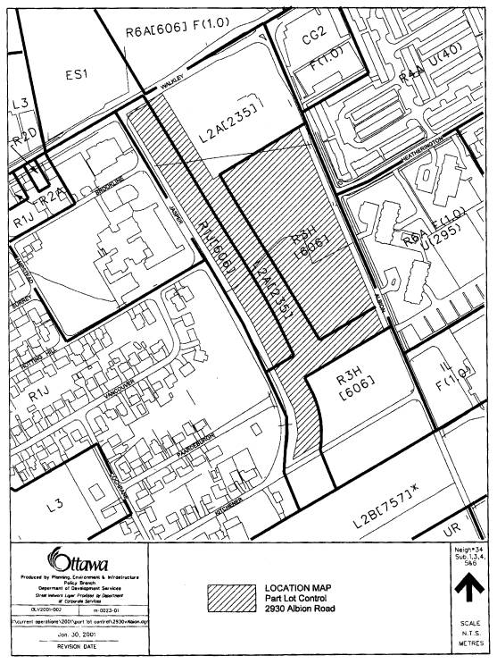
Document 1 - Location
Plan
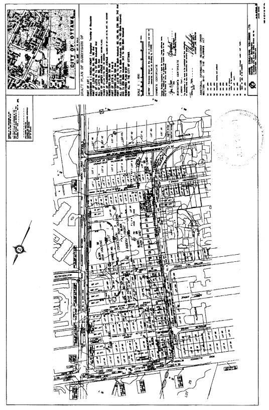
Document 2 - Plan
of Subdivision
Document 3 - Conditions
for Subdivision
Document
4 - Compatibility
with Public Participation Policy/Input from Other Departments or Other
Government Agencies
DISPOSITION
1. Department of Corporate Services, Secretariat Services Branch to notify the agent (210 Gladstone Avenue, K2O 0Y6) and the Region of Ottawa-Carleton, Development Approvals Division, of City Council’s decision.
2.
Legal
Services Branch to
prepare the Subdivision Agreement.
Location Plan Document
1
Plan of Subdivision Document
2
Document 3
1.0 General
1.1 This approval applies to the draft plan certified by, Andrew Shelp, Ontario Land Surveyor, dated 8 January 2001, showing 31 blocks of residential development and one park block.
1.2 That the Registered Owner develop the property in accordance with the requirements of Part 1 of the former City of Ottawa Subdivision Policy, except as otherwise amended herein.
1.3 The owner agrees, by entering into subdivision agreements, to satisfy all requirements, financial and otherwise, of the City of Ottawa, including but not limited to, the phasing of the plan for registration, the provision of roads, installation of services and utilities, and drainage.
1.4 Prior to any further division of lots or blocks, the City of Ottawa may require an additional agreement to address any new or amended conditions.
1.5 The Owner covenants and agrees that prospective purchasers are to acknowledge in writing in the agreement of purchase and sale of being notified of the following items by the registered owner:
a) The location of the purchaser's lot on the registered plan of subdivision.
b) The location of the purchaser's unit on the plan showing the lot lines and the existing proposed surrounding structures.
c) The drainage and topographic plan of the subdivision.
d) The landscape plan for the area of the subdivision.
e) Information, such as brochures and plans explaining the whole development including, but not limited to: the location of all future external roads leading to the proposed subdivision, the proposed land uses of all blocks, the proposed road alignment and land uses of the undeveloped areas of the subdivision and the proposed location for future transit routes or stops near the subdivision, as well as the fact that further information pertaining to the above is available from the City of Ottawa.
f) In accordance with By-law 165-73, homeowners are responsible for the care of all grass boulevards abutting their property.
g) The location of the purchaser's lot and/or block in relation to the surrounding area within 200 metres of the proposed block or lot.
h) A plan showing the ownership of the lots and blocks and land and proposed roads surrounding each individual proposed residential lot and block.
i) The City Council and Ontario Municipal Board approved zoning plan for subdivision and surrounding area.
j) The location and function of the pedestrian paths and parks in the surrounding area in relation to the purchaser's lot.
k) The location, type and size of any utility plant or easement, including hydro electric facility to be located on or near the purchaser's lot.
l) That the activities within the City owned parks or pathways may be a nuisance to the enjoyment of the outdoor amenity areas for the properties abutting or in the vicinity of pedestrian pathway.
m) That the purchaser whose lot and/or block is adjacent to any fencing is responsible to maintain the integrity of that fence in a good and safe condition, including the replacement or reconstruction of the fence.
n) The nature and operation of on-site stormwater management methods.
o) That property
line fencing abutting parklands and pedestrian paths are to be installed on
private property as a condition of subdivision approval and are required to be
maintained by the individual property owner.
1.6 That,
conditional on concurrence with the Departments of Development Services, and
Transportation, Utilities and Public Works, the Owner
shall install Soccer Goal Posts within the proposed Stormwater Management
Facility proposed on the south side of Kitchener Avenue which shall to the
satisfaction of both Departments.
2.0 Zoning
2.1 Prior to registration of the plan of subdivision, the City of Ottawa shall be satisfied that the proposed plan of subdivision conforms with a zoning by-law approved under the requirements of the Planning Act, with all possibility of appeal to the Ontario Municipal Board exhausted.
3.0 Highway/Roads
Right-of-Way Widening
3.1 The owner shall convey at no cost to the City of Ottawa an unencumbered road widening along Walkley Road, measuring 17 meters from the existing centreline of pavement. The owner’s certificate on the M-Plan shall indicate which blocks are being dedicated as a public highway of the City of Ottawa, which Plan shall be submitted in draft to the City Surveyor.
3.2 The Registered Owner shall convey, at no cost to the city, strips of land measuring 2.4 meters in width along the north and along south sides of Kitchener Avenue between Jasper Avenue and Albion Road for road widening purposes. The Owner shall revise the plan of subdivision to identify the lands to be conveyed as parts on the said plan and shall have the lands conveyed as part of the registration of the final plan of subdivision.
Addendum to Traffic Impact Study
3.3 The Registered Owner shall have prepared by a professional transportation engineer/planner, an addendum to the Traffic Impact Study prepared by J.L Richards and dated April 2001. The addendum shall examine alternatives for re-aligning/improving the Jasper/Kitchener Intersection and shall be completed to the satisfaction of the General Manager of Transportation, Utilities and Public Works prior to the registration of the Plan of Subdivision.
3.4 The Registered Owner shall revise, as necessary, the plan of subdivision to reflect any modifications that may be required by the General Manager of Transportation, Utilities and Public Works (following acceptance of the addendum to the Traffic Impact Study required by Condition 1), to re-align/improve the Jasper/Kitchener intersection.
Local Roads
3.5 The Registered Owner shall be responsible for 100% of the cost, design, and construction of proposed Street No. 1 to a local road standard to provide for two driving lanes and a full urban cross-section with a curb-to-curb width of 9.0 m. The proposed road and all associated works shall be completed to the satisfaction of the General Manager of Development Services and the General Manager of Transportation, Utilities and Public Works.
3.6 The Registered Owner Shall be responsible for 100% of the cost, design, and construction to re-align/improve the Jasper/Kitchener intersection in accordance with any determinations made by the General Manager of Transportation, Utilities and Public Works (as set out by Condition 2). The re-alignment/improvement and all associated works shall be completed to the satisfaction of the General Manager of Transportation, Utilities and Public Works.
3.7 The Registered Owner shall improve Jasper Avenue extending from Walkley Road to Kitchener Avenue with a 9.0 meter pavement width and 6 inch barrier curbs (east side) and all associated works to the satisfaction of the General Manager of Transportation, Utilities and Public Works.
3.8 The Registered Owner shall improve Kitchener Avenue extending from Albion Road to Jasper Avenue with a 9.0 meter pavement width and 6 inch barrier curbs (north and south sides) and all associated works to the satisfaction of the General Manager of Transportation, Utilities and Public Works.
3.9 The improvements to Jasper Avenue and to Kitchener Avenue, including the works as may be required by Condition 5 (subject to Municipal Act advertisement and any required public hearings) and works required by Condition 9, are to be completed within one year of the completion of the residential development fronting Jasper Avenue and Kitchener Avenue.
Sidewalks and Pathways
3.10 The Registered Owner shall be 100% responsible for the cost, design and construction of 1.5 meter concrete sidewalks to City of Ottawa specifications with 2.5 meter boulevards (between the curb and sidewalk) along the east side of Jasper Avenue extending from Kitchener Avenue to Walkley Road and along the south side of Kitchener Avenue extending from Jasper Avenue to Albion Road.
3.11 Block 29 shall be conveyed to the City and shall be developed with a pedestrian/bike path leading from the Jasper/Kitchener intersection to the sidewalk along the south side of Walkely Road and to the sidewalk along the west side of Albion Road. The Registered Owner shall be responsible for 100% of the cost for the design, construction and landscaping of the pedestrian/bike path within Block 29. The pathway shall be asphalt with a minimum width of 3.0 meters. The final design for the path and proposed landscaping, including fencing shall be to the satisfaction of the General Manager of Development Services and the General Manager of Transportation, Utilities and Public Works.
3.12 The works required by Condition 10 are to be completed within two years of the issuance of the first building permit to the satisfaction of the General Manager of Development Services.
Streetscaping and Signs
3.13 That a conceptual streetscaping plan showing the design of roads, sidewalks, lighting, and street furniture/signs and the location of all private approaches shall be prepared by the Registered Owner and be approved by the General Manager of Development Services and the General Manager of Transportation, Utilities and Public Works prior to the final approval of the plan of subdivision for the subject lands.
3.14 The Registered Owner shall be responsible for 100% of the cost and installation of all street name signs and traffic signs that may be required to the satisfaction of the General Manager of Transportation, Utilities and Public Works. All signage shall be installed prior to the city’s acceptance of the road(s) within the subdivision.
3.15 The Registered Owner shall comply with the provisions of the Private Approach By-law of the former City of Ottawa for all private approaches.
4.0 Public Transit
4.1 The owner shall:
a) orient dwellings and vehicular accesses in the vicinity of potential bus stops in a manner as to avoid traffic conflicts and visual intrusion and to submit plans for approval by the City of Ottawa indicating the orientation of all dwellings and private accesses in the vicinity of all potential bus stop locations; and
b) inform all prospective purchasers, through a clause in all agreements of purchase and sale and indicate on all plans used for marketing purposes, the location of potential bus stops, paved passenger standing areas, or shelter pads and shelters, which may be located in front of or adjacent to the purchasers’ lot at any time.
4.2 The owner shall design and construct, at no cost to the City of Ottawa, paved transit passenger standing areas, or shelter pads and shelters, to the specifications of OC Transpo.
5.0
Archaeology
The owner shall adhere to the procedures of the “Contingency Plan for the Protection of Archaeological Resources in Urgent Situations” as approved by the Ministry of Citizenship, Culture and Recreation in the Archaeological Resource Potential Mapping Study of the City of Ottawa.
6.0
Environment
6.1 That prior to the issuance of a building permit, the Owner must prepare a sediment and erosion control plan to the satisfaction of the Director, Planning, Environment and Infrastructure Policy Branch, appropriate to site conditions, prior to undertaking any site alterations (filling, grading, removal of vegetation, etc.) and during all phases of site preparation and construction in accordance with current Best Management Practices for Erosion and Sediment Control. (Contact Greg Montcalm, extension 3883)
6.2 That prior to the issuance of a building permit, the Owner must prepare a Waste Audit Summary for the construction project, as required by Ontario Regulation 102/94 of the Environmental Protection Act and provide a copy to the Director, Planning, Environment and Infrastructure Policy Branch. (Contact: Greg Montcalm, extension 3883)
6.3 That the Owner must have its engineering
consultant certify the approved erosion and sediment control plan have been
implemented and monitored during all phases of site preparation and
construction in accordance with current Best Management Practices for Erosion
and Sediment Control. (Contact
Greg Montcalm, extension 3883)
6.4 That the Owner must implement waste reduction as outlined in the Waste Audit Summary as submitted to the Director, Planning, Environment and Infrastructure Policy Branch as a condition of building permit issuance. (Contact: Greg Montcalm, extension 3883)
6.5 Prior to the issuance of a building permit, that the Owner must submit a Municipal Environmental Evaluation Report, to the satisfaction of the Director, Planning, Environment and Infrastructure Policy Branch. (Contact: Greg Montcalm, extension 3883)
7.0 Stormwater
Management
7.1 Construction of an off-site storm water management facility shall be a requirement of this development. The design and construction of the facility shall be to the satisfaction of the General Manager of Transportation, Utilities and Public Works and the General Manager of Development Services, with the design detailing, but not necessarily limited to, the following criteria.
a) that the design of the storm water management facility shall comply with the approved Site Servicing Report for the Walkley Road - Heron Road Subdivision, as prepared by J.L Richards & Associates Limited;
b) that prior to the commencement of construction of the storm water management facility, the Subdivider shall provide the Corporation with the required plans and profiles in Microstation, DGN format. All such plans and profiles shall meet the requirements and specifications of the General Manager of Transportation, Utilities and Public Works and the General Manager of Development Services;
c) that upon completion of the subdivision, the Subdivider shall provide the Corporation with as-constructed plans and profiles in Microstation, DGN format. All such plans and profiles shall meet the requirements and specifications of the General Manager of Transportation, Utilities and Public Works and the General Manager of Development Services; and
d) that landscaping, fencing requirements and the location of the storm water management facility shall be identified.
7.2 The design of the storm water management facility shall be completed and accepted for construction by the City of Ottawa prior to the issuance of the first building permit for of the subdivision.
7.3 No more than a total of 10 building permits shall be issued for blocks 1 to 28 until such time as the storm water management facility has been completed and accepted for use by the City of Ottawa.
7.4 Prior to the commencement of construction of any phase of this
subdivision (roads, utilities, any off site work, etc) the owner shall:
a) Have an Erosion and Sediment Control Plan prepared by a Professional Engineer in accordance with Current Best Management Practices;
b) Have this plan approved by the City of Ottawa; and
c) Provide certification to the City of Ottawa through a Professional Engineer that the plan has been implemented.
7.5 On completion of all stormwater works, the owner shall provide certification to implement in conformity with the Stormwater Site Management Plan.
7.6 Prior to registration, or prior to an application for a Certificate of Approval for any stormwater works (whichever comes first), the owner shall prepare a Stormwater Site Management Plan in accordance with a Conceptual Stormwater Site Management Plan, which the developer also has to prepare. The Stormwater Site Management Plan shall identify the sequence of its implementation in relation to the construction of the subdivision and shall be to the satisfaction of the City of Ottawa and the Rideau Valley Conservation Authority.
8.0 Master Servicing Plan
8.1 Prior to the Registration of the Subdivision Agreement, a Master Servicing Plan shall be prepared to the satisfaction of the General Manager of Transportation, Utilities and Public Works. The Plan shall detail the following:
a) the proposed servicing or alternative servicing scenarios for 2930 Albion Road, including;
i) existing sewer systems in publicly owned right-of-ways;
ii) proposed sewer systems in publicly owned right-of-ways;
b) confirmation of servicing capacity;
c) identification of the sanitary and storm sewer outlets;
d) the post-development run-off coefficient for the site shall not exceed 0.2;
e) the site will be required to retain the 100 year storm prior to accessing an overland flow route;
f) the resolution of any cash-in-lieu issues for storm water quality in the Sawmill Creek Watershed;
g) the proposed phasing of any major infrastructure and in particular the nature and phasing of any storm water management requirements; and
h) specialized construction requirements in consideration of geotechnical conditions, etc.
8.2 The Master Servicing Plan shall also include how future development scenarios for the vacant land located north of Walkley Road will be addressed in conjunction with the servicing and development of 2930 Walkley Road.
8.3 Approval will be required from the Rideau Valley Conservation Authority, and other stakeholder agencies with interests in the Sawmill Creek Watershed, regarding the quantity of storm flow proposed to drain from 2930 Albion Road and the vacant land north of Walkley Road to the Sawmill Creek Watershed.
8.4 Add to the standard Notice to Purchaser Condition – “Notify purchaser of the nature and operation of on-site storm water management methods”.
8.5 Should the Master Servicing Plan indicate that sewer easements will be required for City owned sewers for 2930 Walkley Road, and the vacant land located north of Walkley Road, the easements will be required to conform to the following criteria:
a) The Owner be responsible for 100 percent of the cost to survey, establish and register easements, as required, for sewers to be located on the proposed development site to the satisfaction of the General Manager of Transportation, Utilities and Public Works;
b) The easement is to have a minimum width of 10 metres and is to be centred over the sewer;
c) The easement is to be permanent and registered on title with the property;
d) In cases where a building foundation or road foundation is proposed to abut the easement, the following will be required;
i) An engineering report outlining the effect the proposed structure and its foundation will have on the sewer. Conversely, this same report should also address the effect of the sewer on the proposed structure and its foundation.
ii) Prior
to the start of construction, the Owner agrees to contact the Sewer Operations at the City of Ottawa (Luc Dugal
at 798-8899) to ensure City staff are present during the excavation of any
foundations adjacent the sewer easement.
9.0 Water Services
9.1 The owner shall design and construct all necessary watermains within the subject lands to the satisfaction of the City of Ottawa. The owner shall pay all related costs, including the cost of connection, inspection and sterilization by City of Ottawa personnel.
9.2 The owner shall design and construct all necessary watermains within the subject lands to the satisfaction of the City of Ottawa. The owner shall pay all related costs, including the cost of connection and the supply and installation of water meters by City of Ottawa personnel.
9.3 Upon completion of the installation of all watermains, hydrants and water services, the owner shall provide the City of Ottawa with mylar(s) of the “as-built” plan(s), certified under seal by a Professional Engineer, showing the location of the watermains, hydrants and services. Furthermore, the owner shall provide the “as-built” information and the attribute data for the water plant installation on diskette in a form that is compatible with the City of Ottawa computerized systems.
9.4 Financial security, in the amount of 100% of the value of the water plant, in accordance with the MOE Certificate, must be filed with the City of Ottawa Legal Services Branch, pending preliminary acceptance of the water plant at which time the security may be reduced to 20% of the total cost of construction and installation.
9.5 The installation of the water plant shall be subject to inspection by the City of Ottawa at the owner’s expense.
9.6 The owner prepares, entirely at his cost, a hydraulic network analysis of the proposed water plant within the plan of subdivision and as it relates to the existing infrastructure. Said report shall be submitted to the City of Ottawa for review and approval as part of the water plant design submission.
9.7 The owner shall install the necessary watermains in accordance with the staging schedule approved by the City of Ottawa
9.8 All prospective purchasers will be informed, through a clause in all agreements of purchase and sale, that no driveway shall be located within 3.0 m of an existing fire hydrant. No objects, including vegetation, shall be placed or planted within a 3.0 m corridor between a fire hydrant and the curb, nor a 1.5 m radius beside or behind a fire hydrant.
9.9 All prospective purchasers, will be informed through a clause in all agreements of purchase and sale, that a fire hydrant may be located or relocated, at any time, in front of any lot within the plan of subdivision.
9.10 As the owner proposes a road allowance(s) of less than 20 metres, and if the owner also proposes boulevards between 4.0 and 5.0 meters wide, the owner shall meet the following requirements:
a) Extend water services a minimum of 2 m onto private property during installation before being capped.
b) Install hydro high voltage cable through the transformer foundations to maintain adequate clearance from the gas main.
c) Provide and install conduits as required by each utility.
d) If a sidewalk is to be installed, it shall be located adjacent to the curb and constructed of asphalt. Sidewalks, transformers and hydrants must be placed on opposite sides of the road. Sidewalks must be part of the initial design or not installed at all.
e) Provide and install transformer security walls when a 3 m clearance, as required by the Electrical Code, cannot be maintained. The design and location of the security wall must be approved by the local hydro utility.
f) Install all road crossing ducts at a depth not to exceed 1.2 m from top of duct to final grade.
10.0 Utilities
10.1 Such easements and maintenance agreements which may be required for electrical, gas, water, sewer, telephone and cablevision facilities, shall be provided and agreed to by the owner, to the satisfaction of the appropriate authority; and that the owner shall ensure that these easement documents are registered on Title immediately following registration of the final plan; and the affected agencies are duly notified
10.2 Where the relocation or removal of any existing on-site/adjacent utility facility, including water, sewer, electrical, gas, telephone and cablevision, is required as a direct result of the development, the owner shall pay the actual cost associated therewith to the satisfaction of the appropriate utility authority.
10.3 he owner shall co-ordinate the preparation of an overall utility distribution plan showing the location (shared or otherwise) and installation, timing and phasing of all required utilities (on-grade, below-grade or above-grade), including on-site drainage facilities and streetscaping)-such location plan shall be to the satisfaction of all affected authorities and shall consider their respective standards and specification manuals, where applicable.
10.4 Prior to the issuance of building permits a Composite Utility Plan (based on the coordinated comments of all public agencies) must have been finalized to the satisfaction of the Infrastructure Approvals Branch, Department of Development Services (contact: Dean Aqiqi, 244-5300, ext. 1-3947); and
10.5 Prior to the issuance of building permits the Owner must obtain approval from the Infrastructure Approvals Branch Department of Development Services, of any revision to the Composite Utility Plan if a building permit application does not conform to that finalized Plan (contact: Dean Aqiqi, 244-5300, ext. 1-3947).
11.0 Noise Attenuation
11.1 Prior to the subdivision registration, the Owner shall have a noise study prepared by a Professional Engineer (expertise in the subject of acoustics related to land use planning). The study shall be to the satisfaction of the City of Ottawa and shall comply with MOEE LU-131, Noise Assessment Criteria in Land Use Planning, the City of Ottawa’s Standards for Noise barriers and Noise Control Guidelines, and be in accordance with the current version of the APEO Guidelines, for Professional Engineers providing Acoustical Engineering Services in Land Use Planning.
11.2 The Owner shall implement the specific noise control measures recommended in the approved noise study and any other measures recommended by the City of, Ottawa including as applicable, the City of Ottawa’s “Standards for Noise Barriers” as may be amended.
11.3 Prior to construction of any noise control measures, the Owner shall provide certification to the City of Ottawa through a Professional engineer that the design of the control features will implement the recommendations of the approved study.
11.4 Prior to the registration of the plan of subdivision, the Owner shall provide financial security in the amount of 100% of the cost of implementing the recommended noise control measures; and
11.5 Prior to final inspection, the Owner shall provide certification to the City of Ottawa, through a Professional Engineer, that the noise control measures have been implemented in accordance with the approved study.
12.0 Survey Requirements
12.1 The plan of subdivision shall be referenced, where possible, to the Horizontal Control Network, in accordance with the municipal requirements and guidelines for referencing legal surveys.
12.2 The owner shall provide the final plan intended for registration on diskette in a digital form that is compatible with the City of Ottawa computerized system.
13.0 Parks
13.1
That
Owner dedicate to the City of Ottawa, at no cost to the City, Block 29 for
parkland purposes and that the Owner is responsible for the design and construction
of a linearly continuous pathway throughout Block 29, to the satisfaction of
the Department of Development Services.
13.2
That
prior to the issuance of any building permit, the Owner shall have submitted,
to the satisfaction of the Department of Development Services, a recreational
design proposal for Block 29 which includes the following required works:
a)
a 3.0
metre asphalt pathway to be lit to City standards;
b)
the
grading, topsoiling, seeding or sodding, and the planting of trees and shrubs
within these lands; and
c)
the
installation of wooden or chain link fencing having a minimum height of 1.5
metres along all private property fronting onto Block 29.
13.3 All
works required by conditions 13.1 and 13.2 above shall be completed, to the
satisfaction of the Department of Development Services and Department of People Services prior to the issuance of any
occupancy permit.
14.0 Closing Conditions
14.1 The owner
shall inform the purchaser after registration of each lot or block of the
development charges that have been paid or which are still applicable to the
lot or block. The applicable
development charges shall be as stated as of the time of the conveyance of the
relevant lot or block and the statement shall be provided at the time of the
conveyance. The statement of the owner
of the applicable development charges shall also contain the statement that the
development charges are subject to changes in accordance with the Development
Charges Act, 1997 and the Education Development Charges Act.
14.2 At any time prior to final approval of this plan for registration, the City of Ottawa may, in accordance with Section 51 (44) of the Planning Act, R.S.O. 1990, amend, delete or add to the conditions and this may include the need for amended or new studies.
14.3 The City of Ottawa Subdivision Agreement shall state that the conditions run with the land and are binding on the owner's, heirs, successors and assigns.
14.4 If the plan of subdivision has not been registered by (a date three years after the date of draft approval will be inserted later), the draft approval shall lapse pursuant to Section 51 (32) of the Planning Act, 1990. Extensions may only be granted under the provisions of Section 51 (33) of said Planning Act prior to the lapsing date.
15.0 Financial Requirements
15.1 Upon draft plan approval, City services within the plan of subdivision may be installed provided appropriate financial security, insurance, and a letter of indemnity are posted to the satisfaction of the City Solicitor.
15.2 Prior to registration of the plan of subdivision, the City of Ottawa shall be satisfied that the processing fee has been paid in full.
15.3
Document
4
Participation/Input from Other Departments of
Government Agencies
In addition to the former City of Ottawa’s public
notification procedures, and further supplemented by two public information
meetings held by Councillor Wendy Stewart.
City Councillors
Councillor Diane Deans provided the following
comments:
I am opposed to the development of this site
for it will remove a significant portion of limited greenspace in the Albion,
Heatherington and Fairlea area. The
loss of greenspace to future residential development has been a very
controversial issue in Gloucester-Southgate ward since 1996. Over the years, I have received numerous
telephone calls and letters from residents opposed to the development citing
concerns about loss of greenspace, increased residential density, as well as
recreation and transportation issues.
Due to the history of this land and the controversy
surrounding the proposed residential development I suggest that the Ward
Councillor, Wendy Stewart consider asking that delegated authority be removed
from city staff and that the proposed subdivision agreement go to committee to
allow public participation.
Should the development proposal proceed, the
following are conditions for the subdivision agreement that I wish to put
forward for consideration;
1. Is the applicant required to conduct a
noise study for the block of townhouses at the south-east corner of the
development because they are within the 1000 metres of the zone of influence of
the railway tracks?
2. A storm water management plan for a
‘dry pond’, in combination with a soccer field is proposed by the developer on
the south side of Kitchener Avenue.
Please ensure that the plan is engineered to work as both a soccer field
and a storm water dry pond. Also,
please request the applicant install soccer goal posts on the site. Consideration should be given to requiring
the applicant to sod, instead of seed the soccer/storm water management area.
3. I
have received a request that staff review the feasibility of continuing the
north/south linkage of the Greenway System that is included in this plan by
establishing a public crossing over the railway tracks to link with the South
Keys/Greenboro community.
Response
Points 1 and 2 have been addressed as
conditions for subdivision approval.
Point 3. The approval requires the creation
of an off-site stormwater management facility on the south side of Kitchener
Avenue. This facility will be conveyed
to the City of Ottawa and provide an opportunity for southern pedestrian
linkage should permission to create such a linkage occur with Ontario Hydro and
Canadian National Railway.
Councillor
Wendy Stewart
Councillor
Wendy Stewart has hosted two public information meetings for this subdivision
and is fully briefed on this application’s issues and concerns.
Canadian
National Railway (CN)
CN
strongly indicated their objection to this residential subdivision due to its
proximity to their rail yard. This
subdivision falls within 1000 metres of the rail facility and as such CN
indicates that a noise study is required.
Until such time as a noise study has been provide, CN maintains an
approval of a subdivision for these lands would be premature.
Response
The
developer has indicated that a preliminary noise study has been prepared which
identifies the CN rail yard as a noise source, which can be mitigated. As a condition of subdivision approval, the
developer is required to have a noise study prepared by a Professional
Engineer. This study shall be to the
satisfaction of the City of Ottawa and shall comply with MOEE LU-131, Noise
Assessment Criteria in Land Use Planning, the City of Ottawa’s Standards for
Noise barriers and Noise Control Guidelines, and be in accordance with the
current version of the APEO Guidelines, for Professional Engineers providing
Acoustical Engineering Services in Land Use Planning.
GENERAL
PUBLIC
Comments
were received as a result of the City’s public notification and though two
public meetings held within the community.
These comments have been the summarized and addressed below:
Greenway
Corridor
1. The developer redesign the greenway corridor including a
suggestion that at least one east-west link be created through Jasper Avenue.
2. The preferred use of this land is greenspace. This area already has currently a high
density development community, which is inadequately served. The focus should be on the development of
recreational facilities with the area’s existing open space and not additional
residential development resulting in the loss of a soccer field.
Response
1. The
previous Planning Study for this subdivision, in consultation with the public,
examined options for establishing a greenway corridor. This study, having identified the
preferred location of this corridor,
implemented the appropriate zoning to define and establish this corridor. This subdivision complies with the
recommendations of the Planning Study and subsequent rezoning.
2. The
area in question is largely undeveloped land.
This subdivision, as proposed:
will retain an existing baseball field previously owned by the National
Capital Commission, result in the construction of a lighted pathway system
running north-south through the greenway corridor and, subject to finalization
of a stormwater retention facility, the establishment of a soccer field.
Whether this soccer field would be of a regulation size has yet to be
established.
Parks and Facilities
1. Some
financial contributions should be made by the developer towards the upgrading
of existing recreational facilities.
2. The
“Park or Play Area” should be relocated from the corner of Walkley and Albion
intersection, which is the busiest intersection of this development. In terms of safety, there is the additional
concern relating to the appropriateness of how parking is currently occurring
adjacent to baseball diamond.
3. Inadequate
policing of the park area will be further strained by additional
development. Area is currently
experiencing loitering problems with associated loud music, swearing and
fighting.
4. Existing
park space will be reduced
Response
1. As
a condition of subdivision approval, the developer is required to construct a
pedestrian pathway system within the greenway corridor and convey the lands
associated with the corridor to the City of Ottawa. In addition, if it is determined to be appropriate, the developer
has agreed to provide soccer goal posts within the stormwater management
facility.
2. Because
this is an existing situation and the City of Ottawa currently owns these
lands, it will become the City’s responsibility to determine the
appropriateness of the facilities location and whether it should be relocated. This concern will be forwarded to the People
Services Department for future consideration.
3. The
approval of this subdivision will result in the development of a lighted
pedestrian corridor in an area, which introduce a passive policing by virtue of
its use. Additionally, development of
this subdivision will provide a residential overlook onto the greenway corridor
adding to this area’s security.
4. This
subdivision will result in the further development of park space and perhaps
the acquisition of off-site land to be used as both as a stormwater management
facility and soccer field.
Quality of Life
This development proposal failed to provide an
analysis of the impact on schooling, policing and socio-economic impact this
development will bring onto the existing community.
The various school boards are notified through
a technical circulation of this subdivision application who did not provide a
comment. Since the design and layout of
this subdivision does not differ from a typical subdivision, there were no
policing concerns to have that agency included in a technical circulation. The socio-economic impact of this
development is regarded to be a positive one both providing needed housing and
creating jobs.
Transportation
1. This
area is already under serviced by OC Transpo.
Further development would only further add to the congested buses.
2. Current
vehicular traffic ignore this area’s stop signs. Additional development will further add to this problem.
3. Roadway
network improvements are required such as synchronization of traffic lights on
Walkley Road, and the signalization of Jasper Avenue.
4. There
will be added traffic congestion problems relating to north-south vehicular
movements resulting from this development.
5. This
development will place additional traffic on Kitchener Avenue which is already
congested particularly due to vehicles using Kitchener Avenue as an alternative
route to South Keys Shopping Centre.
6. The
projected increase in traffic indicated by Claridge Homes is too low with
incorrect assumptions of one car per household, and inaccurate assumptions of
transit use for the households.
7. This
development will result in another unwanted stop light along Walkley Road at
Jasper Avenue.
8. There
will be an increase in on-street.
Response
1. OC
Transpo is one of the agencies circulated as part of a technical circulation
for this subdivision proposal. This
circulation provides a statistics by which to plan bus routes and the
opportunity to provide comments on the application. To date OC Transpo has not expressed any concerns relating to
this application.
2. This
is a policing matter, however, this development will form part of the community
whose residents will acquire shared common neighbourhood concerns that will be
reflected in their driving behaviour.
3. A
Traffic Impact Study prepared for this development does not identify a need for
Jasper Avenue and Walkley Road to be signalized.
4. The
Traffic and Parking Operations Branch has indicated that the additional traffic
generated from a development of this size would have a negligible impact on the
north/south volumes running on surrounding arterial roadways.
5. The
traffic impact study prepared for this development indicates that the local
street volumes and street intersection operations will operate within the
recommended guidelines outlined in the former City of Ottawa’s Official Plan.
6. The
traffic impact study was prepared by a professional engineer applying
established transportation industry standards and has been accepted by the
Transportation, Utilities and Public Works Department.
7. Please
refer to response number 3. above.
8. This
development will result in some loss of available on-street parking, however,
the availability of on-street parking will not differ from typical single
family subdivisions and will be greater than those of typical townhouse
developments.
Tenure
The posted on-site information sign does not state whether part or all of this development will be Ottawa Housing.
Response
It is the developer’s intention that all
residential units will become freehold dwellings under private ownership.
Compatibility and Impacts
1. This
development is out of character with existing single family development along
Kitchener Avenue built on 70 foot wide lots and new development should be
compatible with these lots.
2. Development
will have a detrimental effect on the housing prices in the area with proposed
vinyl siding developed within a cramped space.
3. The
townhouses proposed along Kitchener Avenue will be out of character with
existing detached homes.
4. This
development proposal is too dense.
5. This
development will result in an increase in noise and air pollution.
Response
1. This
subdivision proposal locates the single family development to the east of
existing residential along Kitchener Avenue and will front onto Jasper Avenue
which runs north-south. This
subdivision relates more closely with the existing residents fronting onto the
westside Jasper Avenue consisting of single family lots with varying lot widths
average at 13.8 metres. The average
lot width proposed for the east side of Jasper Avenue is 12.2 metres and is
considered to be compatible.
2. There
is no evidence that infill development lowers real estate values. Furthermore, this development will result in
development of park space which will enhance the provision of the overall
area’s amenity space.
3. A
Site Plan Control application for townhouse development proposal at the
northwest corner of Albion Road and Kitchener Avenue however, this proposal
does not form part of this subdivision application. With respect to the appropriateness of townhouse development at
this location, it is should be noted that this development proposal orientates
itself more toward Albion Road and buffer by open space to the south and
west. Given this separation for
existing residential development, it is felt there are no compatibility of use
conflicts.
4. Both
the single family and townhouse development comply with the densities permitted
by the zoning by-law.
5. This residential development is typical
in nature and viewed as having an acceptable environmental impact within the
urban environment.
COMMUNITY ASSOCIATIONS
Ridgemont Community Association
The Ridgemont Community Association suggested
modifications to the greenway corridor, relocation of the recreational area to
the centre of the site, a reduction in the overall density of the proposal, and
that the development made a financial contribution to the upgrading of the area’s
recreational facility.
Response
These concerns have been identified through the
City’s public notification procedures and from comments expressed and received
as a result of public information meetings held by Councillor Wendy
Stewart. Responses to these comments
have been provided above. It should be
noted that, although the Site Plan Control application at the northwest corner
of Albion Road and Kitchener Avenue does not form part of this subdivision
approval, this proposal was presented as part of the concurrent development
applications received within this area.
The applicant has subsequently revised the site plan proposal to reflect
a reduction of townhouse dwelling from 57 units to 30.
South Keys/Greenboro Community Association
The South Keys/Greenboro Community Association
provided the following summarized comments:
First Point
The subdivision lacks details on the
development of townhouses. This is a
concern because in the future as the townhouses may be severed without public
input and would deprive the public of an opportunity to comment on this
development or an opportunity to appeal its approval.
Second and Third Point
This was a summarized expression of concerns
relation to traffic, and loss of on-street parking for visitor parking. This community association also suggested
that townhouses along Albion Road enter into the maintenance agreement required
by those which front onto a private street.
Fourth Point
That the subdivision ensures that the residents
of this suddivision do not encroach onto the Greenway System.
Response
First Point
The subdivision’s development of townhouses
will be subject to a Site Plan Control approval where more detailed drawings
will be provided. This application will
require public notification and circulation to all concerned community groups,
however, this type of development approval is not subject to an appeal by the
public.
Second & Third Point
The portion of the subdivision assigned for
townhouse development creates a public street, which will provide individual
street frontage for each dwelling unit.
Traffic and on-street parking concerns have been previously responded to
above.
Fourth Point
The subdivision requires the developer to
construct a chain link fence to protect the Greenway System.