Report to/Rapport
au:
Planning and
Development Committee/
Comité de l’urbanism et de l’aménagement
and Council/et au Conseil
5 June 2001/
le 5 juin 2001)
Submitted
by/Soumis par: Ned Lathrop, General Manager/Directeur général
Contact/Personne-ressource: Grant Lindsay, Manager, Development
Approvals/ Gestionnaire, Approbation des demandes d’aménagement
|
|
Ref N°: ACS2001-DEV-APR-0141 |
SUBJECT: REGIONAL
AND LOCAL OFFICIAL PLAN AMENDMENTS FOR THE VILLAGE OF MANOTICK
OBJET: MODIFICATIONS DES PLANS DIRECTEURS RÉGIONAL ET LOCAL CONCERNANT LE VILLAGE DE MANOTICK
REPORT RECOMMENDATIONS
That the Planning and
Development Committee recommend that Council:
1.
Approve Amendment No. 22 to the Regional Official Plan
to extend central services to Manotick
2.
Rescind By-law 28/2000 adopting LOPA 2 of the Former
Township of Rideau
3.
Approve Amendment No. 3 to the Rideau Official Plan, a
land use plan for the Village of Manotick
4.
Increase the High Priority – Manotick Service
Engineering Project from $100,000 to $250,000 with funding from the Sewer
Reserve Fund.
5.
Pre-commit $250,000 in the 2002 Capital Budget for the
“High Priority – Manotick Main Street Improvement project.
Que le Comité de l’urbanisme et de
l’aménagement recommande que le Conseil :
1.
approuve
la Modification no 22 du Plan directeur régional en vue d’étendre
les services centraux à Manotick
2.
abroge
le Règlement 28/2000 en adoptant la MPDL 2 de l’ancien Canton de Rideau
3.
approuve
la Modification no 3 du Plan directeur de Rideau, un plan
d’utilisation du sol pour le Village de Manotick
4.
accroître
les fonds au projet hautement prioritaire de génie et d’entretien de Manotick
de 100 000 $ à 250 000 $ en puisant à même le Fonds de réserve des égouts
5.
s’engage
à verser 250 000 $ au budget des immobilisations de 2002 pour le projet
hautement prioritaire d’amélioration de la rue principale de Manotick.
On August 14 2000 the Township of Rideau adopted local Official Plan amendment 2 (LOPA 2), a development plan for the Village of Manotick. The plan for Manotick is a comprehensive land use plan that articulates a vision for Manotick for the future. An amendment to the Regional Official Plan is required to permit the servicing policies (extension of central services to Manotick) proposed in LOPA 2. This report recommends that a comprehensive plan for Manotick be approved and that Planning and Development Committee and Council adopt LOPA 3 and ROPA 22 and allocate additional funds to the High Priority – Manotick Service Engineering Project within the sewer reserve to complete the Environmental Assessment requirements for the project.
DISCUSSION
In 1992 the Township of Rideau updated the Township’s Official Plan, which defined the boundaries of the Village of Manotick. The Region of Ottawa Carleton in approving the Rideau Official Plan deferred Section 3.7.2, Village of Manotick, “until such time as Rideau Township completes a Secondary Plan Planning exercise for the Village of Manotick including a detailed Servicing Options Study, and a Master Stormwater Drainage Plan to the satisfaction of the appropriate agencies”.
In 1996 the Township of Rideau completed and adopted the Stormwater Drainage Plan. In 1995 the Township contracted consultants to undertake a Planning Study (LOPA 2) and a Servicing Options Study (SOS) for Manotick. The two studies were completed in 1997. The Council of Rideau had a number of concerns with the direction of LOPA 2 and it was not adopted by Council. LOPA 2 was revised and adopted by Rideau Council on 14 August 2000.
An amendment to the local Official Plan must conform to the Regional Official Plan. A Regional Official Plan amendment is required to permit the servicing policies (extension of central services to Manotick) proposed in LOPA 2.
In order to deal with both ROPA 22 and LOPA 2 concurrently and comprehensively (i.e. one process for both amendments) staff are recommending that Rideau By-law 28 of 2000 be rescinded and LOPA 2 as modified be adopted as LOPA 3 by the Council of the City of Ottawa. If LOPA 2 is not repealed, the Ontario Ministry of Municipal Affairs will be the approval authority for LOPA 2 and ROPA 22 will be approved by the City (resulting in two notices of decision and different appeal periods) which may create confusion with the public. The contents of ROPA 22 and LOPA 3 are discussed below.
ANALYSIS
The Rideau Official Plan and conditions of approval by the former Region of Ottawa Carleton acknowledge the need to undertake additional planning and engineering analysis prior to further development in Manotick. Three studies a Master Drainage Plan, a Servicing Options Study and a Secondary Plan were prepared in support of a comprehensive development plan for Manotick.
The Master Drainage Plan was adopted by Rideau Township in 1996. It recommended a number of measures including:
The SOS and the Amendment to the SOS were prepared by Robinson Consultants. All activities forming part of the SOS, including public consultation, were designed to meet the requirements of the Ontario Environmental Assessment Act. The studies recommendation/conclusions are as follows:
Development on smaller lots increases the risk of interference between wells and of contamination. The report also concluded that until the present extent and future limit of migration of the contaminated plumes from the core area is determined, there is some inherent risk in constructing communal wells, which have a higher yield, in the vicinity of the plume or in the adjacent surrounding area. The extraction of water in high quantities could influence the movement of contaminates through rock fissures. Connection to central services was concluded to be the best option for providing a safe water supply to Manotick.
Manotick has the largest or one of the largest populations of any village in Ontario that is serviced exclusively by private sewage systems. In 1991 Rideau initiated a survey of private sewage systems in Manotick and the results indicated that there was a significant problem with contamination from malfunctioning private sewage systems in Manotick, particularly in Hillside Gardens and in the core area. The study concluded that the continued use of private individual systems for new development is not an option and connection to central services was the preferred alternative.
The area west of Mud Creek is isolated from the remainder of Manotick by Mud Creek and there would be a greater cost to extending services to the area, therefore there is a logical argument to developing this as an Estate Lot, Special Development Area. Since the majority of the area is underlain by Marine Clay which has a low permeability with a seasonably high water table, it was recommended that the exact location of the terrain units be established and respected. The SOS recommends that development follow the recommendations of the Geo-Analysis Report which recommended minimum lot sizes of between 0.4 ha and 0.6 ha.
The SOS has been circulated to all affected agencies. The Ontario Ministry of the Environment, the City Health and Long Term Care Branch and the Rideau Valley Conservation Authority all support the recommendations of the SOS.
The plan for Manotick is a comprehensive land use plan that articulates a vision for Manotick for the future. The plan provides detailed policies regarding land use, heritage, recreation, growth management and servicing. The SOS described above supports the plan for future development in Manotick as articulated in the LOPA 2.
The local Official Plan amendment that was adopted by Rideau Council in August of 2000 has been revised to address the comments received from City staff and affected agencies. The revised plan is being recommended for approval as LOPA 3. The major revisions are described below.
The plan has been revised to indicate that LOPA 3 is amending Section 3.7.2 of the Rideau Official Plan, replacing the existing policies for Manotick. References to the Secondary Plan have been deleted as this is a land use/development plan for Manotick.
Single Family Development
Outside the Village Core (Section 3.7.2.3 A and B)
The guiding principle for the village has been revised to say “ensure that new residential development located outside of the village core is primarily single family detached housing”. The word primarily has been added to provide some flexibility for minor changes (e.g. adding an apartment for a homeowner’s parent, without requiring an Official Plan Amendment). Similarly the Land Use Objectives (Section 3.7.2. 3 B 3) regarding residential uses in the core has been changed to say “ensure multiple family housing…locate primarily in the Village Core” (as opposed to exclusively in the Village Core). Again this change provides flexibility for minor changes without requiring an Official Plan Amendment.
Both RVCA and Parks Canada have
expressed concerns about future development on Nicholls Island and suggested
that specific policies for this area are required to address the constraints of
the area, which include slope
stability, poor road linkages and servicing limitations and the fact that
central services are not foreseen for this area. A policy has been added to the plan to restrict
development on Nicholls Island
to existing uses to address this concern.
Due to servicing constraints identified in the SOS and the fact that extension of central services to the area is not foreseen, the Business Park designated in LOPA 2 has been changed to a Mixed Use Development Area designation which permits only existing uses.
The designation and policies in
LOPA 2 for the “Special Design Area – Manotick Corporate Campus” have been
deleted from the plan as the area is currently designated “Agricultural
Resource Area” in both the Regional and local Official Plans. No justification has been provided to
justify the village expansion onto agricultural lands.
The area was not addressed in the development plan for Manotick. The SOS did not study the area in enough detail to make a recommendation regarding future servicing of development. The Nepean Official Plan intends that future plans be compatible with the overall plans for Manotick and that prior to any development for these lands that satisfactory arrangements be made with Rideau, covering the following:
a) Direction and staging of development
b) Infrastructure improvements (i.e. Sidewalks, intersection improvements) required to integrate future residential development in this area with the Manotick community
c) Coordination of municipal services
The Nepean Official Plan does not require amendment to provide additional policies for the area but now that there is a development plan for Manotick, prior to any development taking place a concept plan will be required to demonstrate how the lands are proposed to be developed and integrated with the village of Manotick. Specifically the Servicing Options for the area will have to be addressed to determine the appropriate methods to provide services to the area, given the SOS for Manotick.
Protection of the Shore Land (Section 3.7.2.12 policy 2 B2)
At the request of Parks Canada, a policy has been added to state that shore land property owners shall be encouraged to naturalize their shore lands in the interests of improving water quality and to re-establish the natural appearance of the Rideau Canal shore land.
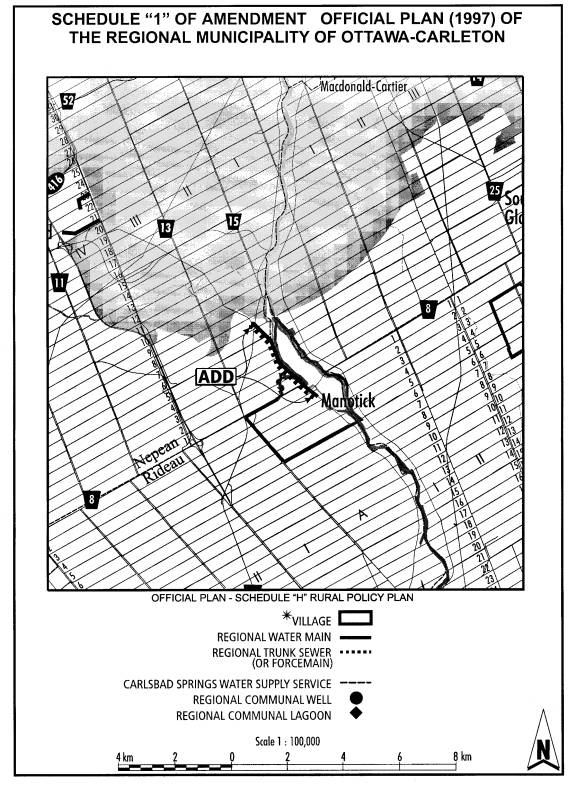
The Regional Official Plan must be amended to permit the servicing policies in the Manotick Plan to be implemented. Section 10.3.7 will be amended to add Manotick as a Serviced Village and Table 13, Servicing Capacity in Villages, will be amended to add Manotick and a total dwelling unit capacity or equivalent of 3,160. Schedule H will be amended to add the extension of the Regional Trunk Sewer to Manotick.
The dwelling unit capacity or equivalent reflects the capacity of the pipe that will be extended to Manotick based on the findings of the Waste Water Master Plan (1997). This dwelling unit or equivalent reflects the total allocation for residential, commercial and institutional uses planned for the village. This number is consistent with the 2,000 dwelling units and the 2,000 jobs in the local Official Plan amendment.
Implementation
In order to implement the policies of the Official Plan for Manotick and the recommendations of the Servicing Options Study, the Environmental Assessment process to extend central services must be completed. It is recommended that the High Priority – Manotick Service – Engineering Project within the sewer reserve be increased to $250,000 (from $100,000) in order to complete the requirements of the Environmental Assessment for Manotick. The $100,000 currently allocated covers only the cost of extending services to the two priority areas (Hillside Gardens and the core area), which have health related problems. The increase in funds will complete the process for the whole village.
Manotick Main Street Improvement
Project
In order to implement the Official Plan’s vision for Manotick it is recommended that $250,000 be pre-committed in the 2002 Capital Budget to allow completion of the community’s “Restoration of Manotick” project according to approved design plans. To date the residents of Manotick in partnership with the municipality have completed $1,175,000 worth of capital improvements in the downtown including the installation of antique lamp posts along Mill Street and on the Island Bridges, a gateway sign and grist mill stone wall at the Main/Bridge Street intersection, the Manotick Clock Towner in the Mews of Manotick, and the restoration of Watson’s Mill. Allocation of funds is necessary to ensure the completion of the “Restoration of Manotick” project.
ENVIRONMENTAL IMPLICATIONS
The SOS for Manotick has identified a number of concerns related to the potential for contaminated drinking water and the presence of failing septic systems in Manotick. LOPA 3 and ROPA 22 provide for the extension of central services to Manotick, which provides a solution for existing servicing problems and ensures that the future development of Manotick will be done in an environmentally responsible manner.
There has been extensive consultation with the community in preparation of the plan for Manotick. Two public meetings (open houses) where held at the Manotick area on 26 September 1996 and 1 April 1997 to discuss the SOS and the development plan for Manotick. In 1998 the Township struck a “Steering Committee” consisting of the Mayor, the Manotick Ward Councillors and seven members of the Manotick community to review LOPA 2 and make amending recommendations. The Public meeting, as required by the Planning Act, for LOPA 2 was held on 15 June 2000.
The public meeting for LOPA 3 and ROPA 22 was advertised in The Ottawa Citizen, the Ottawa Sun and Le Droit to meet the requirements of the Planning Act. Notice of the public meeting was also advertised in the community newspapers, the Manotick Messenger and the Ottawa Carleton Review.
The total cost for extending the central services (sewer and water) to Manotick estimated in the Servicing Options Study is $9,600,000 (GST included). This amounts to an approximate per door cost of $4,800. The non-growth component is currently estimated at 74% of the cost, or $7,100,000. The options for funding this share are: charging to the benefiting property owners through the Municipal Act or the Local Improvement Act; funding by the City; or a combination of the two. If the City was to cover the cost, the Water and Sewer Reserve Funds would be the most likely funding sources.
The growth component, related to new development, is estimated at 26%, or $2,500,000. This element could be covered by development charges, however this project is not in the current Development Charges Study. Further review is required to determine how this would be accommodated.
The funding for the extension of the central servicing will depend on Council’s priorities in the 2002 Capital budget and Forecast process.
The cost of the internal servicing, ie. extending servicing throughout the village, should be implemented on a cost recovery basis, ie. Local Improvement Act or Municipal Act.
The 2001 project, High Priority – Manotick Servicing – Engineering, requires an increase from $100,000 to $250,000 from the Sewer Reserve Fund.
Document 1 ROPA
22
Document 2 LOPA 3 (Colour version of Schedule A will
be issued separately and is held on file with the City Clerk))
Regional Official Plan Amendment Document 1
Purpose
The purpose of Amendment No. 22 is to permit the extension of central services (sewer and water) to Manotick.
Basis
In 1992 the Township of Rideau updated the Township’s Official Plan, which defined the boundaries of the Village of Manotick. Comments from the Ministry of Environment and the Regional Health Department did not support the concept of future growth in the Manotick on the basis of private well supplies and septic tank disposal systems. The Region of Ottawa Carleton, in approving the Rideau Official Plan, deferred Section 3.7.2, Village of Manotick, “until such time as Rideau Township completes a Secondary Plan Planning exercise for the Village of Manotick including a detailed Servicing Options Study, and a Master Stormwater Drainage Plan to the satisfaction of the appropriate agencies”.
In preparing a plan for Manotick the Rideau contracted consultants to complete a Servicing Option Study to investigate and make recommendations regarding future servicing in Manotick. All activities forming part of the SOS, including public consultation, were designed to meet the requirements of the Ontario Environmental Assessment Act. The studies recommendation/conclusions are as follows:
Development on smaller lots increases the risk of interference between wells and of contamination. The report also concluded that until the present extent and future limit of migration of the contaminated plumes from the core area is determined, there is some inherent risk in constructing communal wells, which have a higher yield, in the vicinity of the plume or in the adjacent surrounding area. The extraction of water in high quantities could influence the movement of contaminates through rock fissures. Connection to central services was concluded to be the best option for providing a safe water supply to Manotick.
Manotick has the largest or one of the largest populations of any village in Ontario that is service exclusively by private sewage systems. In 1991 Rideau initiated a survey of private sewage systems in Manotick and the results indicated that there was a significant problem with contamination from malfunctioning private sewage systems in Manotick, particularly in Hillside Gardens and in the core area. The study concluded that the continued use of private individual systems for new development is not an option and connection to central services was the preferred alternative.
All affected agencies including the Ontario Ministry of the Environment, the City Health and Long Term Care Branch and the Rideau Valley Conservation Authority all support the recommendations of the SOS.
The Township of Rideau adopted an official plan amendment, LOPA 2, a development plan for Manotick, which implements the recommendations of the SOS, that new development proceed on the basis of central services.
Regional Official Plan Amendment will permit the extension of central services to Manotick, which is required to implement the SOS and the development plan for Manotick. The dwelling unit capacity or equivalent of 3,160 reflects the capacity of the pipe that will be extended to Manotick. This dwelling unit or equivalent reflects the total allocation for residential, commercial and institutional uses planned for the village.
Schedule H, Rural Servicing, is hereby amended by extending the Regional Trunk Sewer (or Forcemain) to Manotick as shown on Schedule A.
Table 13 in Section 10.3.7 is hereby amended by adding the Village of Manotick and a Total Capacity in Dwelling Units or Equivalent of 3,160.
Table 14 in Section 10.3.7 is hereby amended by deleting the Serviced Area of Manotick and Total Capacity in Dwelling Units or Equivalent of 300 and 34,600 square metres of non-residential floor space.
Local Official Plan Amendment Document
2
Official Plan
Amendment 3
Township of Rideau Official Plan
Manotick is a community located on the south edge of Ottawa’s urban area. The growth and development of the Village is governed, in part, by the Township of Rideau Official Plan. Township Council approved this Plan in 1992. It was subsequently approved by the Regional Municipality of Ottawa-Carleton in 1995, subject to certain modifications, deferrals and one referral.
One of the policies of the Official Plan is to carefully control the rate of growth in the Township’s villages, which includes the Village of Manotick, to ensure that “the present nature of these Villages is not destroyed by rapid expansion”. The Plan also indicates that a Secondary Plan will identify specific growth areas for future residential development, the phasing of development, and the housing mix in the Village using criteria specified in the Official Plan. These criteria were listed in Sections 3.7.2.2, 3.7.2.3 and 3.7.2.4 of the Official Plan. It is these Sections of the Plan, however, that were deferred “until such time as Rideau Township completes a Secondary Planning exercise for the Village of Manotick including a detailed Servicing Options Study, and a Master Stormwater Drainage Plan to the satisfaction of the appropriate agencies”.
The Township undertook the required secondary planning exercise in 1997 and completed the Manotick Servicing Options Study and A Plan for Manotick.
Manotick Servicing Options Study:
The Manotick Servicing Options Study, prepared in 1997 for the Township of Rideau by Robinson Consultants Inc., indicated that there are a number of alternatives to supply treated water to the Village, and to dispose of the Village’s wastewater.
The water supply alternatives included a communal well system, an extension of the central, Regional water system, a water treatment plant in Manotick, an elevated storage tank, or a second supply from the Region’s central system. The study did indicate a preference to connect to the central supply system using an existing main that terminates in the Village core. It was also indicated that the supply main should be supplemented by a storage reservoir and pumping station in Manotick, an elevated storage tank, or a second supply main from the central system.
The wastewater disposal options examined included subsurface disposal systems, a communal system with subsurface disposal, and the pumping of untreated wastewater to the central system for treatment and disposal. Continued use of private individual treatment units for new development was not considered an option for Manotick although it was recognized that many of the existing systems, particularly on large lots, are performing reasonably well and can be expected to do so for a significant period of time. The preference of the study was a conventional gravity sewer within Manotick connected to the Regional system by a pumping station and force main.
A Plan for Manotick:
In the fall of 1997, A Plan for Manotick was presented to Township Council that identified specific growth areas for future residential development, and a proposed housing mix in the Village, along with a number of associated policies to guide the future growth and development of Manotick. The Plan incorporated the recommendations of the Manotick Servicing Options Study. The proposed Plan anticipated a population within the existing Village limits, when fully built, of approximately 8,880 people housed in 3,092 dwelling units. This was referred to as the “design capacity” of the Plan. The “design capacity” was not a population projection and the Plan did not indicate when this population might be achieved. The Plan was recommended for adoption as Official Plan Amendment (OPA) #2 of the Township of Rideau Official Plan.
The Manotick Secondary Plan
Advisory Committee:
The community did not support the approval of A Plan for Manotick when it was presented to Council and suggested it needed further consideration by the residents and businesses of the Village. In response, Council created the Manotick Secondary Plan Advisory Committee, a group of ten citizens, with a mandate “to review the draft OPA and make specific recommendations to the Township’s Committee of the Whole”.
During their review of OPA #2, the Committee determined that a better understanding of the growth prospects facing the Village was needed. Specifically, population, housing and job projections for Manotick to the year 2021 were seen as essential. The results of the Committee’s research were documented in the Manotick Community Profile which were presented as a series of growth scenarios for the years 2006, 2011 and 2021. These findings were presented to the residents of the Village at an open house and workshop which provided an opportunity for the community to further discuss their ideas for the future growth and development of Manotick.
The Manotick Community Planning Quest:
At the workshop, participants were presented with a document called The Manotick Community Planning Quest. The aim of The Quest was to get a sense from the community of their vision of Manotick’s future (i.e., the kind of place they want it to become) through a series of questions and exercises that dealt with such topics as the density of development, the mix of single family housing types, the rate of growth, and the placement of housing, shopping facilities and other business uses in the Village.
Although the workshop participants did not always reach consensus on the detail of each issue, a vision for the future of Manotick did evolve from this exercise. In summary, the community indicated that:
· the Village should grow, but at a conservative rate;
· the type of housing should be in keeping with what is there today;
· commercial activities should remain separate from housing and those commercial activities should be located in the core;
· areas of environmental interest should be conserved;
· the physical and social heritage of the community – the Mill, the Village spirit and rural ambience – should be preserved;
· new investment should be directed to the core to improve the community’s economic base; and,
· the growth that will be required to accomplish this should be well managed.
The responses to this exercise, along with the studies that preceded it, helped craft a vision for the future of Manotick, and a growth management strategy. The Manotick Secondary Plan Advisory Committee also used the results of The Quest to help them define a series of objectives for the Secondary Plan.
An Amendment to the Servicing Options Study was adopted by Rideau Council to support the Official Plan and the community vision for Manotick.
This document is the guide to the long-term
growth and development of the Village of Manotick, based on a vision of the
Village that the residents of Manotick hold. This document also provides
guidelines for day-to-day decision making on land use planning.
Section 3.7.2 is
hereby deleted in its entirety and replaced with the following:
3.7.2 VILLAGE OF MANOTICK
3.7.2.1
The
Community’s Vision for Manotick
This is the Village the residents of Manotick want for their children. It is a simple word picture that attempts to capture what the residents and businesses of the Village see as the kind of place they want Manotick to become. Many of the pieces of this Vision exist today, but not all. The Vision, together with the Plan Objectives which follow in Section 3.7.2.2, provide the context within which to interpret the policies of this Plan.
Manotick is a lively and welcoming Village. Each day of the week the
core of the Village is alive with Villagers shopping, or socializing with
friends and neighbours. The core has
evolved from its early beginnings as a working class neighbourhood surrounding
a gristmill, to an area recognized for its historic relevance, its pedestrian
friendly environment, and as a place of commerce. Main Street is lined with unique storefronts and business
outlets that support the day-to-day needs of Manotick’s residents.
The Village’s built heritage has become one of its defining
elements. New buildings that have been
erected in the core acknowledge this past in their scale, form and
character. This, along with its natural
setting adjacent the Rideau River, has provided a coherence to the Village that
makes it an attractive and interesting place.
The
Village core is also home to seniors, professionals, young families and recent
graduates. Some of these people have
chosen to live in the former houses of the mill workers. Others have taken up
residence in one of the newer townhouses or walk-up apartments. With piped services, these infill
developments have taken over land that was at one time needed for private
septic systems.
From the Village core, bicycle paths and
walking trails lead to an interconnected network of open spaces, many framing
the watercourses that meander though these areas. Beyond, the paths and trails
lead to the established neighbourhoods on Long Island and the newer residential
areas of Manotick. West of Mud Creek
where there is an estate atmosphere, the houses are situated on large lots
along winding streets, many backing onto environmental preserves. Adjacent and bordering these areas are
somewhat smaller houses not unlike those found on Long Island. This combination of single family housing,
along with the infill development of townhouses and walk-up apartments in the
Village Core, has made the community affordable to a broad range of households
with varying incomes.
The
development of these new residential areas has meant that the Village has
experienced growth. But the growth and
development has occurred at a gradual rate so that the community spirit and the
essential character of the Village have been kept. The Village has grown and
flourished. It has welcomed new residents who have brought new life and ideas
to community activities and reinforced the spirit of the Village.
3.7.2.2 PLAN OBJECTIVES Throughout the various meetings and workshops with the residents and businesses where the future of Manotick was being discussed, the community was clear on how they saw the Village evolving, and what role the Official Plan was to play in the process of guiding the Village’s future growth and development. They also saw the need to clearly spell out these objectives so that there would be a context within which informed decisions could be made when dealing with such issues as the Village’s land use planning, development, conservation of its heritage and environmental resources, and the future provision of municipal infrastructure. The following section details those objectives. It is these objectives that are the foundation of the policies of this Plan. |
|
|
|
Preserve and Maintain the Existing Quality
and Character of Life |
|
|
|
Federal, Provincial & Regional Policies |
|
Rideau Official Plan
|
2. To provide policies to conform with the Official Plan for the former Township of Rideau and the General Policies of the Township’s Official Plan; |
Periodic Review |
3. To provide for the periodic review of this Plan and its performance not less frequently than each five (5) years and to take action as deemed appropriate where the Plan’s performance is proceeding in a manner which is not consistent with the Primary Objective; |
Natural Resources |
4. To conserve Manotick’s natural resources and to encourage their preservation; |
Rideau River Shoreline |
5. To provide for the preservation and/or acquisition of the Rideau River shoreline and its availability for public enjoyment; |
Heritage Resources |
6. To conserve and enhance Manotick’s heritage resources and the Village’s identity and character as an historic town on the Rideau Canal National Historic Site, a Canadian Heritage River; |
|
7. To protect and enhance the environmental quality of the Rideau Canal (River), a Canadian Heritage River, by encouraging shore land property owners to naturalize their shore lands in the interests of improving water quality and to re-establish the natural appearance of the Rideua Canal shore land |
Infrastructure
|
8. To provide a strategy for the provision of infrastructure to Manotick; |
Pedestrian and Cycling Routes |
9. To provide safe, convenient and pleasant pedestrian and cycling routes throughout the Village; |
Compatibility with Established Character
& Built Form |
10. To ensure compatibility of any new development or redevelopment with the existing community and its established character in terms of the type, scale and built form of the new development or redevelopment; |
Village Core Commercial |
11. To protect and enhance the commercial functions of the Village core; |
Jobs & Housing |
12. To provide adequate opportunity for jobs and housing in the overall community in a manner that is desirable for a Village and consistent with the community’s Vision; |
Recreation & Leisure Facilities |
13. To provide recreation and leisure facilities that are conveniently located and accessible to all residents; |
Orderly Growth & Development |
14. To provide for an orderly growth and development strategy within the Village; and, |
Housing Mix |
15. To provide an adequate mix of housing in the Village as a whole as opposed to any one residential neighbourhood or new development area. |
3.7.2.3 GROWTH MANAGEMENT The growth management guidelines for the Village of Manotick which follow are based on the Community’s Vision for Manotick as stated in 3.7.2.1 of this Plan, and the Plan Objectives as detailed in Section 3.7.2.2. The principles provide the direction on which to manage the future growth and development of the Village. |
|
|
A Rural Village |
|
Single Family Outside the Village Core |
|
Village Core as a “Gathering Place” |
|
Village Setting |
|
Manage Growth |
|
Conserve Heritage, Develop Sensitively |
|
Pedestrian Oriented
|
|
Compatible Infrastructure |
Retail Commercial
|
|
Predominance of Single Family |
|
Residential Uses in the Core |
|
Manage Growth |
Servicing Solution |
|
Adjacent Lands |
|
|
|
To manage the growth of the Village, Council shall: |
|
Village Growth |
|
Monitor the Plan’s Performance |
|
Housing Mix
|
|
Servicing the Growth
|
|
|
|
A. General
|
|
|
|
Village Core Limits
|
|
Meeting Place |
|
Village Character Areas
|
|
Built and Natural Environment |
Preservation of Vegetation |
|
Pedestrian Friendly
|
|
Gateways
|
|
Zoning Tools |
|
|
|
Village Core Defined
|
|
Character Areas |
|
The Core as the Village Centre |
|
Area of Heritage Interest |
|
Existing Vegetation
|
|
Respect for Architectural Character |
Council shall
ensure new development in the Village Core respects the scale, form and
character typical of buildings in the historic areas of the Village
Core. Accordingly, Council may
develop zoning and other land use regulations and tools that will assist in
implementing this policy. This may
include such regulations as “build to lines”, building envelops, upper storey
set backs, signage and other façade and roof treatment provisions. In the interim, building heights will be
limited to a maximum of three storeys throughout the Village Core. |
Pedestrian Friendly
|
|
Gateway Development |
|
Sense of Enclosure
|
i) provide a sense of enclosure by being set close to the street with parking hidden from view; and,
|
Signal to Motorists
|
ii) signal to motorists that the area being entered is one that gives priority to pedestrians which may be accomplished through narrowing the road and/or the generous use of various landscaping elements such as wide sidewalks, benches, street trees and other pedestrian amenities. |
B. Commercial Uses in the Village Core
|
|
|
|
Vibrant Commercial Area
|
a) To encourage and promote the Village Core, with an emphasis on the Main Street and The Mews Character Areas, as vibrant retail areas that serves the people and businesses of the Village, and the surrounding rural community. |
Historical Character |
b) To ensure that retail facilities developed in the Village Core respect the Core’s historical character and existing scale of development. |
|
|
Encouraging Commerce in the
Core. |
a) Council shall promote the development of the Core, with a focus on the Main Street and The Mews Character Areas, as a place of commerce and business transactions. |
Locating Commercial Uses in the Core |
b) Council may permit retail uses throughout the Village Core, including those uses that enhance the Village’s evolving tourism potential such as restaurants and hotels, to the extent permitted by policies of the Village Core Character Areas. Refer to 3.7.2.4 E for detailed Character Area policies including permitted uses. |
Historical Character |
c) All new development within the Village Core shall be sensitive to, and respect, the historical character and existing scale of development within the Village Core. |
|
|
|
|
Multiple Family Housing
|
a) To encourage the development of multiple family housing, which includes duplex houses, townhouses and walk-up apartments, throughout the Village Core to provide for a wide variety of household types and income levels. |
Residential Above Commercial |
b) To encourage residential development to be located above the ground floor of retail uses, or behind retail uses, throughout the Village Core. |
Respect Heritage Character |
c) To encourage residential development to be sensitive to, and respect, the historical character and existing scale of development within the Village Core. |
|
|
Housing Mix in the Core. |
a) Within the Village Core, Council shall support the development of duplex houses, townhouses and walk-up apartments, the permitted areas for which are defined by the Character Areas policies (see 3.7.1.4 E.). |
Compatibility of New Housing. |
b) New development in established residential areas within the Village Core shall respect the historical character and scale of the existing residential development. |
|
|
|
|
Mix of Public and Institutional Uses |
a) To encourage a mix of public and institutional uses within the Village Core. |
|
|
Institutional and Community Services in
the Core. |
a) Public and institutional uses shall be permitted in the Village Core. The Character Area policies provide the details for the location of each of these uses, as noted in Section 3.7.2.4 E. |
|
|
When considering new development within the Village Core, Council shall refer to the policies of the applicable Character Areas as identified on Schedule A. The policies applicable to each of the Character Areas follow. |
|
1. Bridge
Street: This Character
area is currently a mix of retail, residential, public and institutional uses
with varying setbacks from the right-of-way that results in a loose
definition to the edge of Regional Road 8 as it passes through the Village.
The long term goal for this area is to make it more residential in character,
to have new development placed close to the road so that it “reads” more as
an internal, residential street rather than a through route, and to ensure it
remains a safe, convenient access between the Bridge Street, Main Street and
The Historic Village Character Areas. |
|
Pedestrian and Vehicular Gateway |
a) Council shall ensure that Bridge Street continues to function both as a pedestrian and vehicular gateway into the Village Core providing ease of access between those portions of the Village located on either side of the Rideau River. |
Orientation of Development |
b) The design of new development within the Bridge Street Character Area shall reinforce the gateway function of the street by orienting buildings toward the street and positioning those buildings close to the sidewalk, with parking hidden from view, to form a continuous frontage along the Street and a sense of enclosure to the road. |
Landscaping to Reinforce Gateway |
c) Landscaping of new and existing development shall be encouraged to reinforce the gateway function of the street through the generous use of various landscaping elements as wide sidewalks, benches, street trees, signage and other pedestrian amenities. |
Multiple Family Housing
|
d) Council may permit the development of multiple family housing throughout the Bridge Street Character Area. |
Public and Institutional Uses
|
e) Public and institutional uses shall be permitted throughout the Bridge Street Character area. |
Retail Commercial Uses Limited
|
f) Retail uses within the Bridge Street Character Area will be limited to those properties zoned for this purpose as of the date of approval by Council of this Official Plan. |
Permitted Retail Commercial Uses |
g) Properties zoned commercial in the Bridge Street Character Area, in addition to those uses lawfully existing as of the date of approval by Council of this Official Plan, shall be limited to offices. |
1088 and 1090 Bridge Street |
h) Development of the property municipally known as 1088 and 1090 Bridge Street shall be governed by a previous OMB decision concerning the property which is as follows: “Notwithstanding the provisions to the contrary, the subject lands
shall be limited to commercial uses, to allow the existing gas bar and
ancillary convenience store. “For greater clarity, “existing gas bar”
refers to the gas bar (buildings and pumps) as it existed at the time of the
commencement of the hearing on this matter, that is September 9, 1996, but
does not refer to the site dimensions.
An ancillary convenience store is defined as having a maximum floor area
of 93 square metres. “As these lands are located in the Rideau River/Canal Corridor, in the approach to the core of the Village of Manotick, and on a street connecting two Scenic Routes under the Regional Official Plan, in any development, expansion, or redevelopment, consideration must be given to architecture and aesthetics.” |
2. Main
Street: This Character
Area is the community’s historic shopping street. Together with The Mews, it
is the area within which Manotick’s retail facilities and services are
concentrated. Unlike The Mews, however,
Main Street’s emphasis is on the pedestrian with its on-street parking,
narrow street cross section, and small scale buildings set close to one
another. The long term goal for Main
Street is to reinforce this identity and its function as a pedestrian oriented
retail street where shops mix easily with such uses as restaurants and
business services. |
|
Pedestrian Oriented |
a) The Main Street Character Area shall be pedestrian oriented and may include such retail uses as stores, business and personal services, tourism/entertainment facilities, banks and other financial services. Offices will be encouraged to locate in The Gaps Character Area. |
Gateways |
b) The intersection of Main Street with Bridge Street in the north, and at the location on Main Street between Potter Drive and Catherine Street, as noted on Schedule A, shall be developed as gateways into the Main Street Character Area and the Village Core. |
Built Form |
c) Council shall ensure new development in the Main Street Character Area respects the existing scale, massing (e.g., placement on the site) and character typical of buildings in the Area. |
Residential Above Retail Commercial |
d) Residential development, provided those uses are located above the ground floor of retail commercial uses, shall be permitted within the Main Street Character Area. |
Public and Institutional Uses Limited |
e) Public and institutional uses in the Main Street Character Area will be limited to those properties zoned for this purpose as of the date of approval by Council of this Official Plan. New public and institutional uses shall be encouraged to locate in The Gaps Character Area. |
Parking |
f) To reinforce the pedestrian orientation of the Area, its safety and convenience, the parking requirements for uses within the Main Street Character Area shall be minimal, existing on street parking shall be retained and, in the case of designated heritage properties no parking may be required. |
Streetscape Concept and Design Guidelines |
g) As a priority, Council shall ensure that the streetscape concept for the Main Street Character Area defined by the report entitled “Main Street Manotick” (Corush Sunderland Wright, November, 1997) is implemented, and the design guidelines are referenced in the consideration of new development within the Character Area. |
3. The
Historic Village This Character
Area encompasses the historic settlement of the Village of Manotick,
including Watson’s Mill. Together
with the Main Street Character Area, it expresses the Village’s fundamental
character and its identity. The east
sector of the Historic Village is a mixture of office, institutional,
residential and retail uses. It
includes the headquarters of the Rideau Valley Conservation Authority,
boutiques, and a variety of other retail uses. The west sector of the Character Area is essentially the “back
lots” of the retail uses that line the west side of Main Street. This area includes surface parking lots
and some retail uses that extend west into the block interior from a frontage
on Main Street. The long term goal for
this Area is to reinforce the evolving character of its east sector as an
area of boutiques, galleries, specialty outlets, restaurants, studios and
craft workshops intermingled with residential uses, while developing the west
sector for housing, and some parking to serve the Main Street retail
area. |
|
East Sector Uses |
a) The Historic Village (east sector) shall be pedestrian oriented and may include such retail uses as specialty boutiques, galleries, restaurants, craft outlets, other tourism and entertainment facilities, and residential uses, including multiple family housing. Offices will be encouraged to locate in The Gaps Character Area. |
Mixed Use |
b) Developments within The Historic Village (east sector) may be used for both retail and residential purposes (i.e., two or more permitted uses may be physically integrated within a building, or separate buildings on the same lot). |
Built Form - East Sector |
c) Council shall ensure new development in The Historic Village Character Area (east sector) respects the existing scale, massing (e.g., placement on the site) and character typical of buildings in this area. |
Public and Institutional Uses Limited |
d) Public and institutional uses in The Historic Village Character Area (east sector) will be limited to those properties zoned for this purpose as of the date of approval by Council of this Official Plan. New public and institutional uses shall be encouraged to locate in The Gaps Character Area. |
Parking |
e) To reinforce the pedestrian orientation of the Area, its safety and convenience, the parking requirements for uses within The Historic Village Character Area (east sector) shall be minimal, existing on street parking shall be retained and, in the case of designated heritage properties no parking may be required. |
Mill “Quarter” |
f) Council shall examine the feasibility of developing a “Mill Quarter” around Watson’s Mill, including the potential relocation of the offices of the Rideau Valley Conservation Authority, for commercial accommodation, boutiques, galleries, craft and other specialty outlets, museums, restaurants, and studios. |
West Sector Uses
|
g) The Historic Village (west sector) shall be encouraged to develop as a combination of well landscaped, small shared parking areas to serve the retail uses on Main Street, interspersed with multiple family accommodation fronting onto Ann Street. |
4. The
Post Office District This Character
Area wraps around the west side of the Main/Bridge/Maple Streets’
intersection and extends north almost to the junction of Main Street with
Regional Road 8. The predominant use
in this Area is professional and business services. It also includes the local post office building and a multiple
family housing development. The long
term goal for the Post Office District is to improve its appearance as the
north entry point into the Village, and infill vacant and underutilized lots
with multiple family housing. |
|
Permitted Retail Commercial Uses |
a) Retail uses on properties zoned for this purpose within the Post Office District Character Area, in addition to those uses lawfully existing as of the date of approval by Council of this Official Plan, shall be limited to offices. Other retail uses shall be encourage to locate in the Historic Village, Main Street and The Mews Character Areas. |
Multiple Family Housing |
b) Council may permit the development of multiple family housing throughout the Post Office District Character Area. |
Public and Institutional Uses Limited |
c) Public and institutional uses in the Post Office District Character Area will be limited to those properties zoned for this purpose as of the date of approval by Council of this Official Plan. New public and institutional uses shall be encouraged to locate in The Gaps Character Area. |
Orientation of Development |
d) The design of new development within the Post Office District Character Area shall reinforce the gateway function of Main Street by orienting buildings toward the Street and positioning those buildings close to the sidewalk, with parking hidden from view, to form a continuous frontage along the Street and a sense of enclosure to the road right-of-way. |
Landscaping to Reinforce Gateway |
e) Landscaping of existing development within the Post Office District shall be encouraged to reinforce the gateway function of Main Street through the generous use of various landscaping elements as wide sidewalks, benches, street trees, signage and other pedestrian amenities. |
5. The
Mews This Character
Area is the Village’s automobile oriented retail area. The dominant use in this area is The Mews
Shopping Centre. The long term goal
for this area is to improve its internal vehicular circulation pattern and to
soften its rather harsh pedestrian environment through landscaping its surface parking areas and the “voids”
between buildings. |
|
Retail Uses |
a) The full range of retail uses may be permitted in The Mews Character Area including retail stores, business and personal services, and banks and other financial institutions. Retail uses which are suited to a pedestrian environment shall be encouraged to locate in the Main Street and The Historic Village Character Areas. |
Residential Development |
b) Residential development shall be permitted within The Mews Character Area. |
Public and Institutional Uses |
c) Public and institutional uses shall be permitted throughout The Mews Character Area. |
Open Areas between Buildings |
d) Open areas between buildings within The Mews Character Area shall be encouraged to be developed as pedestrian linkages to areas outside the Character Area, and as small parkettes or “outdoor rooms” for the enjoyment of pedestrians and shoppers. |
Pedestrian Friendly, Landscaped |
e) Redevelopment of The Mews parking areas shall be encouraged to a pedestrian friendly environment which shall include the addition of landscaped features and vegetation. |
Internal Vehicular Circulation |
f) Council shall examine the feasibility of redesigning the vehicular circulation network within The Mews Character Area such that internal circulation serving the shopping centre integrates better with the overall circulation pattern within the Character Area and the adjacent public road network. |
6. The
Arena This Character
Area is where the Village’s major recreation facilities are located including
its arena, tennis courts, baseball diamonds and other outdoor recreation
facilities. The long term goal for
this Character Area is to maintain and further develop this Area as the
community’s focus for its major recreation and athletic activities. |
|
Community Gathering and
Entertainment |
a) The Arena Character Area shall continue to be the major venue for local community events, recreational, sport, social and entertainment events. |
Mixed Use – Recreational and
Public |
b) The development and expansion of a mixed-use recreational and public use complex shall be considered for this location to serve the emerging demands of the Village’s population. |
7. “The
Gaps” This Character
Area has an unfocussed mix of retail, office, residential and industrial uses
and open spaces. It appears as
unkempt. The Character Area, however,
has the potential to develop a strong employment and multiple family,
residential focus for Manotick. It
has the potential to form a important link between the historic Village
centre, and its shopping and recreation centre by providing accommodation for
a “24 hour population” of residents and employees in this part of the
Core. It has the capacity to
encompass uses that could form a fundamental underpinning of the community’s
economy. The long term goal for The
Gaps Character Area, therefore, is to see it develop as an area of employment
and multiple family housing. |
|
General Commercial, Multiple Family
Residential, Mixed Use |
a) Council shall promote this area for general commercial use, with a particular emphasis on office developments, as a multiple family district, including seniors housing, and a mixed use area encompassing various public and institutional facilities. |
Conceptual Development Scheme |
b) To promote the development of this area in the manner envisioned, Council will prepare a conceptual development scheme (i.e., a demonstration plan) that will graphically illustrate the potential of this Character Area to investors, and serve as a detailed guide to the development of the Character Area. This scheme should be undertaken as an initiative with local land owners, businesses and residents. Innovative urban design, continuity in building styles, scale and façades, extensive landscaping and attractive streetscaping should all be part of this strategic initiative. |
3.7.2.5
HOUSING IN THE VILLAGE (Outside the
Village Core) |
|
The planning objectives for Housing in the Village, outside the Village Core, that are derived from the Community’s Vision for Manotick and the Plan Objectives are: |
|
Maintain Single Family Predominance |
a) To ensure single-family, detached housing remain the predominant form of housing in the Village, outside the Village Core. |
Existing Neighbourhoods |
b) To ensure that developed residential areas, outside the Village Core, retain their existing character, mix of housing types and density of development. |
|
|
Locating Residential Development. |
a) Residential development outside the Village Core shall be located in areas designated “Single Family (Estate)’, “Single Family (Low Density)” or “Single Family (Moderate Density)” as indicated on Schedule A. |
Single Family (Estate)
|
b) Single Family (Estate) areas may have a density of one to two units per gross residential acre (i.e., 2.5 to 5 units per gross residential hectare). |
Single Family (Low Density)
|
c) Single Family (Low Density) areas may have a density of two to four units per gross residential acre (i.e., 5 to 10 units per gross residential hectare). |
Single Family (Moderate Density)
|
d) Single Family (Moderate Density) areas may have a density of four to six units per gross residential acre (i.e., 10 to 15 units per gross residential hectare). |
Gross Residential Defined |
e) “Gross residential” refers to a unit of land, either an acre or hectare, designated for residential development on Schedule A, and does not include lands designated as “School”, “Open Space”, “Watercourse”, “Significant Woodlot” or “Development Setback”. |
Development within Existing
Neighbourhoods Serviced Development Area Conditions |
f) New infill development and redevelopment in existing residential neighbourhoods, outside the Village Core, shall be compatible with adjacent, existing housing with respect to lot size and configuration, and building size and setback. g) Areas designated Serviced Development Area on Schedule A shall be developed without amendment to this Plan provided the following conditions are satisfied: i) All development shall be on the basis of central water and wastewater services. ii) A comprehensive development concept plan has been prepared for the entire area, to the satisfaction of the City of Ottawa, that will facilitate the logical phasing of development in the area (the integration of transportation links, parks and open space, schools pedestrian links and stormwater) and that will form the basis for various, subsequent plans of subdivision; iii) The location and ownership of the schools, recreation and/or open space areas will be to the satisfaction of Council, and determined in consultation with the affected land owners and the Manotick community; |
Special Design Area: Estate Residential
and Open Space |
h) Council may permit the area on Schedule A designated as “SDA: Estate Residential and Open Space” to be developed as a residential area, without amendment to this Plan, provided the following conditions are satisfied: |
Conditions |
i) A comprehensive development concept plan has been prepared for the entire area, to the satisfaction of the City of Ottawa, that will facilitate the logical phasing of development in the area (the integration of transportation links, parks and open space, pedestrian links, servicing and stormwater) and that will form the basis for various, subsequent plans of subdivision; |
|
ii) The residential component of the concept plan is comprised exclusively of Single Family (Estate) lots;
|
|
iii) The development concept plan shall ensure that development in the “SDA Estate Residential and Open Space” is distinct from the development in the serviced part of the village (larger lot sizes, lower density, more open space). The plan shall recognize that parts of the area designated are important groundwater recharge areas or have soils unsuitable for tile field construction that are more suited to uses such as recreation and/or open space (e.g., nature trails, active and passive parks, natural areas, etc.); |
|
iv) The location and ownership of the recreation and/or open space areas will be to the satisfaction of Council, and determined in consultation with the affected land owners and the Manotick community; |
|
v) All residential plans of subdivision must have a density of development that conforms to the Township of Rideau approved hydrogeological report, “Hydrogeological Suitability Extension of Manotick Development Area” by GeoAnalysis dated 4 April, 1989 (i.e., average minimum lot size: 0.4 to 0.6 hectares) as amended by more current investigations; |
Nicholls Island |
|
(Outside the Village Core) |
|
The planning objectives for Employment Areas in the Village, outside the Village Core, that are derived from the Community’s Vision for Manotick and the Plan Objectives are: |
|
Location of Employment Areas |
a) To encourage employment opportunities outside of the Village Core to to be located primarily outside of the village boundary, at the Highway 416/Bankfield Interchange. |
|
|
Locating Business Industrial Uses. |
a) Council shall support the location of business and other employment generating uses generally outside of the village boundary around the intersection of Bankfield Road and Highway in the area designated “Industrial” on Schedule A, provided that a study is completed to justify the lifting of the Deferral No. 2 to the Rideau Official Plan to permit the use of the site for commercial and industrial uses. The study shall demonstrate: i) that the land designated is immediately adjacent to Highway 416 interchange; ii) justification for the need for the use and the size of the area to be designated; iii) that there is no reasonable alternative location which avoids Agricultural Resource Areas; iv) that there no reasonable alternative location in Agricultural Resource Areas with lower capability soils for agriculture; v) that adequate water and wastewater services can be provided; vi) that the permitted uses do not conflict with existing agricultural uses, and meet local needs or the needs of the traveling public, or are related to rural resources that require large tracts of land and are therefore not suitable for a village location; vii) that suitable design and landscaping will be provided in keeping with the role of Highway 416 as an Entry Route to the National Capital; viii) opportunities to provide tourist orientation facilities, wherever feasible. |
Mixed Use Development. |
b) Development in the area designated “Mixed Use Development” shall be restricted existing uses recognizing the servicing limitations of the site and the fact that central services are not foreseen for this area. |
3.7.2.7 VILLAGE COMMUNITY SERVICES AND INSTITUTIONAL USES |
|
1. Objective: The planning objectives for Community Services and Institutional Uses in the Village that are derived from the Community’s Vision for Manotick and the Plan Objectives are: |
|
Range of Community Service &
Institutional Uses |
a) To provide for a range of community service and institutional uses which support the needs of the Village and its residents. |
2. Policies: To achieve the planning objectives for Community Services and Institutional Uses, the following are Council’s policies: |
|
Locating Community & Institutional
Uses |
a) Community services and institutional uses shall be centrally located in residential areas along collector roads and pathways to provide ease of access for vehicles, pedestrian and cyclists, and in selected Character Areas of the Village Core. |
Permitted Community Service and
Institutional Uses |
b) Community service and institutional uses that may locate in residential areas include schools, community centres, places of worship, senior citizen and day care centres. Community service and institutional uses that may locate in the Village Core include special needs care facilities, government offices and facilities, and those uses permitted in residential areas. |
School Sites |
c) Council shall ensure that there are an adequate number of school sites dedicated to accommodate facilities to serve the students generated by the development of new residential areas within the Village of Manotick. |
3.7.2.8 VILLAGE OPEN SPACE AND RECREATIONAL
AREAS |
|
1. Objectives: The planning objectives for Open Space and Recreational Areas in the Village that are derived from the Community’s Vision for Manotick and the Plan Objectives are: |
|
Cycling Network
|
a) To provide a network of cycling and pedestrian paths throughout the Village. |
Safe and Convenient |
b) To create a safe and convenient cycling and pedestrian environment. |
Open Spaces – Maintain & Expand |
c) To maintain and expand upon open spaces and recreational areas. |
2. Policies: To achieve the planning objectives for Open Space and Recreational Areas, the following are Council’s policies: |
|
Pedestrian and Cycling Network. |
a) The pedestrian and cycling network as conceptually identified on Schedule A shall consist of continuous pathway linkages throughout the residential areas that link these areas to the Village Core, major recreational facilities and other open spaces. |
Dedication of Open Space |
b) In newly developing residential areas, Council shall require adequate dedication for the development of parks, open spaces and pathways through the subdivision and site plan processes. |
Applying Section 5.8 of Rideau Official
Plan. |
c) Council shall ensure, in addition to Section 5.8 of the Township of Rideau's Official Plan, that the following policies shall apply: |
Natural Area |
i) The area between the east and west branches of the Wilson Cowan Drain located north of Century Road East shall be retained as a natural area; |
Providing Neighbourhood Parks. |
ii) An eastern and western open space node shall be developed in the area located south of the Potter Drive residential area as indicated on Schedule A, the intended function of which are neighbourhood parks and shared open spaces with possible future school sites; |
Long Island as Public Open
Space. |
iii) As recommended by the Riverbends Study of the Rideau Valley Conservation Authority, the northern limit of Long Island shall be reserved and designated as public open space once acquired by a public authority to connect the Parks Canada lands on Nicholl's Island with the existing open space area. |
Boat Launch Facilities. |
iv) The existing boat launch facilities at Bridge Street and the existing private open space located south of Bridge Street adjacent the west channel of the Rideau River shall be designated and preserved for open space. These facilities may continue their current operations, with redevelopment and improvement permitted as required, subject to all necessary approvals. The shape and size of this open space area shall be determined in the long-term redevelopment of this area. |
3.7.2.9 VILLAGE UTILITIES & SERVICING The Manotick Servicing Options Study 1997 and the Amendment to the Servicing Options Study 2000 prepared by Robinson Consultants Inc. indicated that there are a number of alternatives to supply treated water to the Village, and to dispose of the Village’s wastewater. Alternative, long term solutions for water supply include a communal well system, extension of the central Regional system, a water treatment plant in Manotick, a reservoir and pump station, and individual private wells. The study indicated that the option chosen will vary with the area in the Village served, and that a combination of private individual wells, small communal systems and connections to the central supply system are possibilities. The Study’s preferred option for the long term, given the Village’s anticipated growth, is to supplement the connection to the central system that currently serves the core and Hillside Gardens, so that the whole Village, over time, can be provided with treated water from the central system. |
|
The wastewater disposal options examined included subsurface disposal systems (e.g., private septic systems), a communal system with subsurface disposal, and the pumping of wastewater to the central system for treatment and disposal. Continued use of private individual treatment units for new development was not considered an option for the plans proposed for Manotick. It was recognized, however, that many of the existing systems are performing reasonably well, particularly on large lots, and can be expected to do so for a significant period of time. The study concluded that the only realistic alternative for the disposal of wastewater from Manotick is to pump it to the central Regional system. . |
|
Priority areas within the Village as identified by the Study for connection to Regional systems, both treated water and wastewater, were the Village Core and Hillside Gardens (north portion of Long Island). The Study confirmed significant problems from malfunctioning private systems in the core area of Manotick. Significant problems were also noted in the Hillside Gardens area which has resulted in very high bacteriological loading to surface waters. Further septic system failures in the Core and Hillside Gardens, the Study noted, may result from increased water consumption as a result of the recent servicing of these areas by the regional water supply system. Subject to detailed terrain analysis and hydrogeology investigation the study concluded that because it is isolated from the rest of the village, the area West of Mud Creek could be permitted to develop on estate lots, on private services with a minimum lot size that will clearly distinguish this area from the remainder of the village designated for central water and sewage. |
|
|
|
1. Objectives:
|
|
Transition to Central Infrastructure |
a) To provide for a gradual transition from private individual services, including wells and wastewater disposal systems, to a central water supply, and a wastewater treatment and disposal system. |
Surface Drainage New Development Areas |
b) Concurrently with the transition to central systems for the supply of water, and the disposal of wastewater, to undergo a gradual change from surface drainage to a managed stormwater system. c) To require areas designated New Development Area to be on the basis of central water supply, and a wastewater treatment and disposal system and managed stormwater system. |
2. Policies: |
|
Connection to Wastewater Disposal &
Treatment |
a) Council shall make every effort to secure the immediate connection of priority areas within the Village (i.e., the Village Core and Hillside Gardens [north portion of Long Island]) to the central wastewater treatment and disposal system to complement the existing central regional water supply serving Manotick. |
Council’s Position on Funding Priority
Areas |
b) Council’s position in securing the immediate connection of the priority areas within the Village to the central water and wastewater treatment and disposal system is that: |
Central System Connection |
i) The connection of the Village to the central water and wastewater treatment and disposal system is to be funded through on a proportional basis by the City, for existing development and through Development Charges for new development; and, |
Individual Lot Connections |
ii) The connection of each lot within the priority areas to the central system will be on a cost recovery basis, except in cases of an identified public health and environmental need where funding assistance may be provided by the City and/or senior levels of government, or where special funding assistance may be available through a senior government capital grant program. |
Extension & Funding of to
Non-Priority Areas |
c) Council’s position concerning the extension of the central wastewater treatment and disposal system, and the central water supply to existing lots within the Village, outside the priority areas, and undeveloped areas as designated on Schedule A, is that: |
Existing Lots |
i) For existing lots outside the priority areas, the connection of each lot to the central systems will be implemented on a cost recovery basis, and where sufficient demand by potential users warrants, except in cases of an identified public health and/or environmental need where funding assistance may be provided by the City and/or senior levels of government, or where special funding assistance may be available through a senior government capital grant program. |
New Development Areas |
ii) For New Development Areas designated on Schedule A, the connection of each new lot to the central system will be required as a condition of subdivision approval, the cost the design and installation of which is to be financed in full by the developer of the proposed subdivision. |
Use of Existing Private or
Communal Systems |
d) The continued use of existing private individual, or communal water and wastewater disposal systems shall be monitored to determine the implications of the continued use of these systems on: |
Criteria
|
i) The public health and safety of Village residents; ii) The conservation and protection of the natural environment; and, iii) The ability of the municipality to fully implement the Village of Manotick’s servicing strategy. |
Council Action |
e) Where it is determined that there is a negative consequence to the continued use of existing private individual, or communal water and wastewater disposal systems, Council may take whatever action is deemed appropriate to secure the immediate connection of the areas within the Village for which there is a concern, to the central wastewater treatment and disposal system, or central water supply system, in accordance with Policy 3.7.2.9 A.2 a) ii) above. |
|
|
Adhering to Master Drainage
Plan |
1. Council shall ensure that the servicing designated New Development Area and Special Design Area: Estate Residential and Open Space effectively implements the current Master Drainage Plan for the Village. In that regard, new development shall be required to construct underground or surface drainage systems as deemed appropriate by the City. |
Co-ordinating with Adjacent Government
Agencies. |
2. Council shall coordinate with other government agencies and authorities, in defining servicing solutions required to manage storm water drainage (both water quality and quantity) in Manotick, including temporary storage and holding areas both within and adjacent the Village’s boundaries. |
|
|
Central System
|
1. A central wastewater disposal and treatment system shall be provided throughout the Village, over time, in accordance with the Village of Manotick servicing strategy. |
Existing Private Sanitary Systems. |
2. Existing private sanitary sewage disposal systems may continue to be used in areas of existing development throughout the Village provided those systems do not jeopardize: |
Criteria
|
a) The public health and safety of Village residents; b) The conservation and protection of the natural environment; and, c) The ability of the municipality to fully implement the Village of Manotick’s servicing strategy. |
Circumstances Allowing Private
Individual Systems |
3. Council shall not support private individual systems for new development, except in the case of undeveloped infill lots in registered plans of subdivision or individual lots of record which meet the criteria of the applicable approval authorities and do not jeopardize, in the opinion of Council, the ability of the municipality to fully implement the Village of Manotick’s servicing strategy. An amendment to the zoning by-law shall be required.
|
|
|
Central System
|
1. A central regional water supply shall be provided throughout the Village, over time, in accordance with the Village of Manotick servicing strategy. |
Prioritizing Piped Water Supply |
2. When prioritizing the construction and installation of a central water supply system in the Village, Council shall refer to the following criteria to assist in setting which area(s) should receive priority: |
Priority Criteria |
a) The installation is deemed necessary to remedy a public health or safety problem; |
|
b) The density of development is greater than 10 units per hectare (4 units per acre); |
|
c) The installation of is based on an approved Local Improvement Scheme; and, |
|
d) The installation is part of an approved capital works program. |
3.7.2.10 VILLAGE STREETS, TRANSPORTATION AND
TRANSIT |
|
1. Objectives: |
|
Safe, Accessible and Efficient |
a) To support the Village's character and vision by providing for the safe, accessible and efficient movement of pedestrians and vehicles throughout the community. |
Pedestrian Friendly, Transit Accessible |
b) To promote a pedestrian friendly and transit accessible environment, particularly in the Village Core. |
2. Policies: |
|
Section 6 of Official Plan Apply |
a) Section 6, Transportation Policies of the Township of Rideau, Official Plan apply to the Village of Manotick. |
Road Requirements - New
Subdivisions. |
b) Council shall ensure that the development and layout of future local roads in new subdivisions are subject to subdivision and site plan control, and designed using standards which complement the Village's character. |
Providing Pedestrian and Cyclists Links |
c) Council shall pursue the development of a safe and convenient network of pedestrian and bicycle routes, pathways and linkages throughout the Village as conceptually identified on Schedule A. |
Sidewalks
|
d) Where feasible, sidewalks shall be provided on both sides of all regional roads and on one side of collector roads, and where special conditions warrant, sidewalks may be required on one side of local roads. |
Transit Services |
e) Council shall encourage transit services to be extended to Manotick as the Village evolves and demand warrants, and shall ensure the priority area for this service is the Village Core. |
Gateways |
f) The following design guidelines apply to gateways designated on Schedule A: |
Village Gateway Design
Guidelines. |
i) Gateways should incorporate landmark features including architectural light standards, Village signage, intensive landscaping, and where operationally feasible, traffic islands; and, |
|
ii) Development adjacent streets that bisect gateways should be oriented toward the street and include extensive landscaping with parking areas hidden from view. |
Shoreline Properties - Commercial Parking
Restrictions and Special Landscaping Requirements |
g) Parking lots of commercial developments situated next to the Rideau River, shall not be located adjacent the shoreline frontage of those properties, and where a commercial property abuts or is in close proximity to the Rideau River, special landscaping shall be incorporated into the site plan for the proposed development of that property that mitigates the visual impact of such parking areas as viewed from the Rideau River (refer to Policy 12.0 B 2.) |
3.7.2.11 VILLAGE ENVIRONMENTAL MANAGEMENT |
|
1.
Objective: |
|
Preserve & Protect
|
|
2. Policies: |
|
Applying Section 5.7 of the Official Plan |
|
Environmental Protection Areas |
|
Constraint Lands
|
|
|
|
1. Objectives: |
|
Location of Heritage Interest |
a) To define the location of heritage interest. |
Protect Heritage Interest |
b) To protect the existing built and natural areas of heritage interest. |
Heritage as an Economic Foundation |
c) To build on the existing heritage in the Village to create a venue that is attractive and interesting. |
2. Policies: |
|
Applying Existing policies |
|
Area of Heritage Interest |
|
Creating a Heritage District |
|
Respect for Architectural Character |
|
|
|
Waterfront Access & Views
|
1. Public access and views to the Rideau River should be conserved and enabled when opportunities arise. |
Views from the River
|
2. Views from the Rideau River to developments along the shoreline, should be enhanced through the application of design and landscaping principles comparable to those principles that apply to the design and landscaping of the frontages of residential properties. Shore land property owners shall be encouraged to naturalize their shore lands in the interests of improving water quality and to re-establish the natural appearance of the Rideau Canal shore land
|
Heritage Resources
|
3. Heritage resources should be conserved and enhanced as a building block of the community’s economy. |
Institutional Landmarks
|
4. The existing character and identity of Manotick, in particular its institutional landmarks, should be conserved and enhanced as the most prominent elements of the Village’s skyline. |
Transition Zones
|
5. Transition zones, or buffers, should be provided between areas of similar use but markedly different densities, or between different and potentially incompatible uses and areas. |
Natural Areas, Land Forms
& Watercourses as Defining Elements
|
6. Natural environment areas should be conserved and enhanced, and significant land forms and watercourses should be recognized and incorporated into newly developing areas as defining elements of the Village’s urban form and pattern of land use. |
3.7.2.13 VILLAGE PLAN IMPLEMENTATION |
|
1. Objectives: |
|
Village Vision |
|
Implement Growth Management |
|
Preserve Village Character |
|
2. Policies: |
|
Phasing of Development |
|
Co-ordinated, Natural & Logical
Progression |
|
Monitoring Development |
|
Monitoring Criteria |
i) The rate of growth experienced in the Village over the reporting period; ii) The facilities required to service that growth (e.g., schools, parks and other recreation facilities) and whether or not those facilities have been developed or are planned in the foreseeable future; iii) The capacity of volunteer organizations to meet the needs of new residents (e.g., the provision of recreation programs); iv) The capacity of the road network to accommodate the growth demonstrated through such factors as traffic counts at key Village intersections; and, v) Other indicators as deemed appropriate by Council. |
Servicing Strategy |
|
Adjacent Lands |
|
Sections 3.7.2.5 & 3.7.2.7
Apply |
|
Zoning Bylaw |
|
Holding Zones |
|
Criteria |
i) The approval of a plan of subdivision; ii) The provision of adequate park and school land dedication and facilities to serve the proposed area; iii) The provision of adequate transportation services for the proposed area; iv) The approval of a site plan control application and a site plan agreement; v) The provision of adequate services in accordance with the Village of Manotick servicing strategy as detailed in Section 3.7.2.9, Village Utilities and Servicing; and/ or, vi) Such other matters as may be required by Council. |
Development Application Review |
|
Studies |
i) Environmental impact study; ii) Servicing feasibility study; iii) Hydrogeology study; iv) Soils and geotechnical study; v) Noise impact and attenuation study; vi) Transportation and traffic study; vii) Market feasibility and impact analysis study; viii) Financial impact study; ix) Urban design study and architectural guidelines; x) Social impact study; and/or xi) Other studies as may be deemed required by Council. |
Conditions of Development Approval |
|
Conserve Environmental Features |
i) The developer and all successor owners shall incorporate and conserve existing woodland areas and watercourses into their development including those not specifically designated on Schedule A; and, |
Cost Sharing Agreements |
ii) The developer and all successor owners of the development shall enter into a cost sharing agreement with the City with respect to the provision of infrastructure, community and recreation facilities, and transportation improvements required to serve the proposed development area. |
Subdivision Approvals and
Consents |
|
Site Plan Control Approval |
|
Special Studies |