|
3. ZONING
– 1045 SPRUCE RIDGE ROAD ZONAGE
– 1045, CHEMIN SPRUCE RIDGE |
COMMITTEE RECOMMENDATION
That
Council approve an amendment to Zoning By-law 2008-250 to change the
zoning of 1045 Spruce Ridge Road such that a holding symbol (h) is added to the
existing zone, as shown in Document 1 and detailed in Document 2.
RECOMMANDATION DU
COMITÉ
Que le Conseil approuve
une modification au Règlement de zonage 2008-250, et ce, afin de modifier le
zonage du 1045, chemin Spruce Ridge en ajoutant le symbole h (symbole
d’aménagement différé) au zonage actuel, comme le montre le document 1 et
l’explique en detail le document 2.
Documentation
1. Deputy City Manager’s Report, Planning and Infrastructure Services dated
30 March 2012 (ACS2012-PAI-PGM-0059).
Report
to/Rapport au :
Agriculture and Rural Affairs Committee
Comité
d'agriculture et des affaires rurales
and Council / et
au Conseil
30 March 2012
/ le 30 mars 2012
Submitted by/Soumis par : Nancy Schepers, Deputy City Manager/Directrice
municipale adjointe, Planning and Infrastructure/Urbanisme et Infrastructure
Contact
Person/Personne-ressource : Derrick Moodie, Manager/Gestionnaire, Development
Review-Rural Services/Examen des projets d'aménagement-Services ruraux,
Planning and Growth Management/Urbanisme et Gestion de la croissance
(613) 580-2424, 15134 Derrick.Moodie@ottawa.ca
|
SUBJECT: |
|
|
|
|
|
OBJET : |
REPORT RECOMMENDATIONS
That the Agriculture and Rural Affairs
Committee recommend Council approve an amendment to Zoning By-law 2008-250 to
change the zoning of 1045 Spruce Ridge Road such that a holding symbol (h) is
added to the existing zone, as shown in Document 1 and detailed in Document 2.
RECOMMANDATIONS DU RAPPORT
Que le Comité de l’agriculture et des affaires rurales
recommande au Conseil d’approuver
une modification au Règlement de zonage 2008-250, et ce, afin de modifier le
zonage du 1045, chemin Spruce Ridge en ajoutant le symbole h (symbole
d’aménagement différé) au zonage actuel, comme le montre le document 1 et
l’explique en detail le document 2.
BACKGROUND
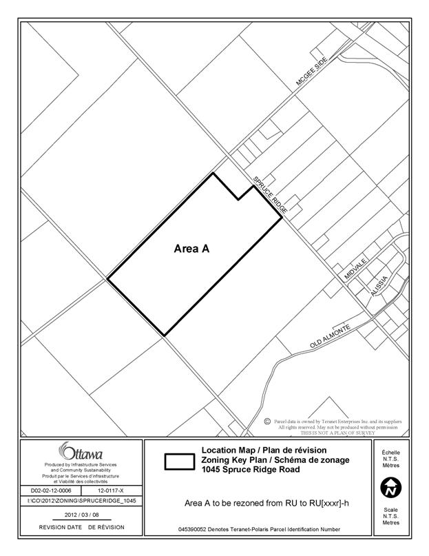
The subject land is located on the
southwest corner of McGee Side Road and Spruce Ridge Road. The site is currently vacant, surrounded by residential and rural uses, as well as identified
natural features.
In September 2011, 1045 Spruce Ridge
Road was subject to a severance application through the Committee of Adjustment
(D08-01-11/B-00320). The severance was
conditionally approved to permit the conveyance of 72.8 hectares from 1035
Spruce Ridge Road. A condition of the
approval was to establish a holding provision on the subject property.
Purpose of Zoning Amendment
The purpose of the amendment is to
place a holding provision on the property to limit the permitted uses to
existing uses until the required studies, as set out by the Committee of
Adjustment decision, are completed to the satisfaction of the City. The required studies are as follows:
- An
Environmental Impact Statement to deal with the Rural Natural Feature,
Significant Woodlands and Threatened and Endangered Species issues;
- A Geotechnical
Assessment to determine the limitations of organic soils;
- A
Limestone Resource Impact Analysis; and
- A
hydrogeological evaluation to demonstrate the adequacy of the aquifer with
respect to quality and quantity to support the proposed development.
The intent of the application is to prohibit development on this parcel
until such time as the applicant has demonstrated that a suitable building
location can be found that respects environmental, aggregate and health and
safety concerns.
Existing Zoning
The current zoning of the parcel is RU
(Rural Countryside) under Zoning By-law 2008‑250. This zone permits a limited range of rural-based
uses including agricultural, forestry,
country residential lots created by severance and other land uses
characteristic of Ottawa’s countryside.
Proposed Zoning
The requested zoning amendment
proposes to change the subject
property from RU to RU[XXXr]-h. The
holding provision will be used to
prohibit development including the issuance of a building permit for any
structure on the property until such time as an Environmental Impact Statement,
a Geotechnical Study and a Limestone
Resource Impact Analysis have been undertaken, to identify an appropriate
building envelope on the site. The
holding provision will ensure that only existing uses are permitted on the
site.
DISCUSSION
Official Plan
According to the Official Plan, the
subject land is designated Rural Natural Features Area. Rural Natural Features are natural areas in
the rural area that contain significant woodlands, wetlands, and wildlife
habitat. Any development within or
adjacent to these areas must be assessed in terms of its impact on the area’s natural
features and functions.
The
Environmental Impact Statement must demonstrate that there will be no negative
impact on the natural features or ecological function of the Rural Natural
Features and Significant Woodlands.
These features are important for maintaining biodiversity and ecological
functions within the City.
The property
is located immediately south of a Limestone Resource Area. The Official Plan stipulates that no
development may occur within 500 metres of a Limestone Resource Area unless a
Limestone Resource Impact Analysis demonstrates that the mineral aggregate
operation, including future expansion in depth or extent, will not be affected
by the development and vice versa.
Schedule K
of the Official Plan also identifies that portions of the property are
constrained by organic soils. The
policies of the Official Plan state that a Geotechnical Study must be submitted
to demonstrate that the soils are suitable for development.
By placing a
holding provision on this property until the required studies are submitted, the
aforementioned concerns will be addressed.
Zoning
By-law
The site is zoned RU, which accommodates
a variety of rural-based uses characteristic of Ottawa’s countryside.
The intent of the application is to prohibit development on this parcel
until such time as the applicant has demonstrated that a suitable building
location can be found that respects environmental, aggregate and health and
safety concerns.
Staff are confident that the property
is sufficiently large that all of these constraints can be satisfied. The applicant has requested that these
studies be deferred until a proponent determines where a dwelling is intended
on the 73 hectare property. This will
allow for the studies to be focused on the area affected by development.
RURAL IMPLICATIONS
The rural
environmental area will be protected through the proposed zoning and there will
be no rural implications.
CONSULTATION
Notice of this application was carried
out in accordance with the City's Public Notification and Consultation
Policy. The City did not receive any
negative comments or opposition to this application.
COMMENTS BY THE WARD COUNCILLOR
The Ward Councillor is aware of this
application and the staff recommendation.
LEGAL IMPLICATIONS
There are no legal implications associated with this
report.
RISK MANAGEMENT IMPLICATIONS
There are no risk management implications associated
with this report.
FINANCIAL IMPLICATIONS
There are no
financial implications associated with this report.
ACCESSIBILITY IMPACT
ENVIRONMENTAL IMPLICATIONS
TECHNOLOGY IMPLICATIONS
There are no direct technical
implications associated with this report.
TERM OF
COUNCIL PRIORITIES
The implementation of a holding
designation enables the lands to be severed in a sustainable manner. The Zoning By-law amendment ensures that
development will only occur on the lands after environmental and health
concerns have been fully addressed.
APPLICATION PROCESS TIMELINE STATUS
The application was not processed by
the "On Time Decision Date" established for the processing of Zoning
By-law amendments due to the timing of Agriculture and Rural Affairs meetings.
SUPPORTING DOCUMENTATION
Document 1 Location Map
Document 2 Details of Recommended Zoning
DISPOSITION
City Clerk and Solicitor Department,
Legislative Services to notify the owner, applicant, OttawaScene Canada Signs, 1565 Chatelain Avenue, Ottawa, ON K1Z 8B5, Ghislain Lamarche, Program Manager,
Assessment, Financial Services Branch (Mail Code: 26-76) of City Council’s decision.
Planning and Growth
Management
to prepare the implementing by-law, forward to Legal Services and undertake the
statutory notification.
Legal Services to forward the
implementing by-law to City Council.
LOCATION MAP DOCUMENT
1
DETAILS OF
RECOMMENDED ZONING DOCUMENT
2
Proposed
Changes to the Comprehensive Zoning By-law
1. The
subject property be rezoned from RU to RU[xxxr]-h.
2. Section
240 of By-law 2005-280 be amended by adding a new exception with provisions
having the same effect as the following:
- all
permitted uses are prohibited until such time as the holding symbol is removed
from the land
- the
holding symbol cannot be removed until the following are completed to the
satisfaction of the City:
an
Environmental Impact Statement to deal with the Rural Natural Feature,
Significant Woodlands and Threatened and Endangered Species issues;
a
Geotechnical Assessment of organic soils is undertaken;
a Limestone
Resource Impact Analysis; and
a Hydrogeological
Investigation that demonstrates the adequacy of the aquifer with respect to
quality and quantity to support the proposed development.