3. Orléans
Watermain Link
Raccordement
des conduites principales d’Orléans
COMMITTEE
RECOMMENDATION
That
Council approve the results of the Class
Environmental Assessment Study for the Orléans Watermain Link as detailed in
Documents 1 and 2 and direct staff to
proceed with Notice of Study Completion for a 30-day public review period in
accordance with the Ontario Municipal Class Environmental Assessment Schedule
"B" process.
RECOMMANDATION DU COMITÉ
Que le Conseil approuve les résultats de l’Étude d’évaluation environnementale de portée
générale sur le raccordement des conduites d’eau principales d’Orléans, comme l’indiquent les documents 1 et 2, et de
charger le personnel de diffuser un Avis d’achèvement d’étude pour une période
d’examen public de 30 jours, conformément au
processus d’évaluation environnementale de portée générale de l’Ontario (annexe
B).
DOCUMENTATION :
1.
Deputy City
Manager, Planning and Infrastructure report dated 25 April 2012 (ACS2012-PAI-PGM-0107);
2. Extract of Draft Minute 3 May 2012, follows the French
report.
Report to/Rapport au :
Comité de l’environnement
and Council / et au Conseil
25 April 2012
/ le 25 avril 2012
Submitted by/Soumis par : Nancy Schepers, Deputy City
Manager, Directrice municipale adjointe, Planning and Infrastructure/Urbanisme
et Infrastructure
Contact Person/Personne-ressource : Richard Kilstrom,
Manager/Gestionnaire, Policy Development and Urban Design/Élaboration de la
politique et conception urbaine, Planning and Growth Management/Urbanisme et
Gestion de la croissance Élaboration de la politique et conception urbaine
(613) 580-2424 x22653,
Richard.Kilstrom@ottawa.ca
|
SUBJECT: |
|
|
|
|
|
OBJET : |
REPORT RECOMMENDATION
That the Environment
Committee recommend Council approve the results of the Class Environmental Assessment Study for the
Orléans Watermain Link as detailed in Documents 1 and 2 and direct staff to proceed with Notice of Study Completion for a
30-day public review period in accordance with the Ontario Municipal Class
Environmental Assessment Schedule "B" process.
RECOMMANDATION
DU RAPPORT
Que le Comité de l’environnement recommande au Conseil d’approuver les
résultats de l’Étude d’évaluation
environnementale de portée générale sur le raccordement des conduites d’eau
principales d’Orléans, comme l’indiquent les
documents 1 et 2, et de charger le personnel de diffuser un Avis
d’achèvement d’étude pour une période d’examen public de 30 jours, conformément au processus d’évaluation
environnementale de portée générale de l’Ontario (annexe B).
BACKGROUND
The Orléans Watermain Link (OWL) was originally
identified in the 1997 Water Master Plan (RMOC) and the need for this watermain
was reaffirmed in the 2003 and 2009 Infrastructure Master Plans (IMP). The purpose of this link is twofold:
·
To
increase the reliability of the water supply to the East Urban Community (EUC);
and
·
To
augment water transmission capacity to EUC in order to meet the needs of future
urban development.
The project was originally planned for
implementation between 2017 and 2021. However,
the timing of the project was re-evaluated as part of the 2009 IMP, and it was
recommended that the project be constructed to provide greater reliability to
the EUC sooner.
The overall OWL project will complete
a reliable and continuous secondary water supply route to the EUC.
The schedule for implementing the OWL has
two main drivers: it is needed in order to allow for the construction of the Ottawa
Light Rail Transit (OLRT) project in coordination with the widening of Highway
417 (Nicholas to the Split); and it is required to increase the reliability of
water service to the City’s East Urban Community to mitigate supply risks.
Water is currently supplied to the EUC
through a primary transmission main that runs roughly along Highway 417,
Highway 174, and St. Joseph Boulevard. There is also a secondary
transmission main that runs parallel to the primary transmission main between
the Rideau River and St. Laurent Boulevard. Following the most recent IMP
update, work has been completed to assess related water supply risks along the
section between the Rideau River and Blair Road. A key risk that was
indentified through this process was that this secondary main needs to be moved
before OLRT construction. The proposed OWL will ensure that a continuous flow
of water to the EUC is maintained throughout and following the LRT construction
period without interruption.
It is noted that a separate Environmental
Assessment (EA) is being initiated on the relocation existing transmission main
between Lees Avenue and the Hurdman Pumping Station (located between the Rideau
River and Vanier Parkway). The need for
this separate EA is also driven by the widening of the 417 bridge over the
Rideau River, however, this project’s scope remains distinct from the Orléans
Watermain Link EA study.
Increasingly, maintaining the quality
and reliability of municipal water systems is a significant challenge for all
communities, and Ottawa is no different. For decades, a large water
storage reservoir in Orléans has provided for some level of redundant and
back-up water supply to the area. However, with expanding suburban
growth, this level of redundancy is no longer sufficient to provide an
acceptable level of service in the event of an extended transmission failure,
and thus, a secondary transmission main must be extended through the Eastern
Greenbelt and into the Orléans area. In Ottawa, the East Urban Community will
be the last area to have this level of redundancy constructed into the system
as secondary transmission mains have already been constructed to the south
and west urban areas. The OWL will also be sufficient to allow the City to accommodate
future growth without the need to install another transmission main.
DISCUSSION
A Schedule B Class Environmental Assessment
and Functional Design have been completed for the OWL. A wide range of conceptual alternatives were
considered, including various routes both north and south of Highways 417 and
174. A formal screening and evaluation
process was followed, and a preferred alternative was identified.
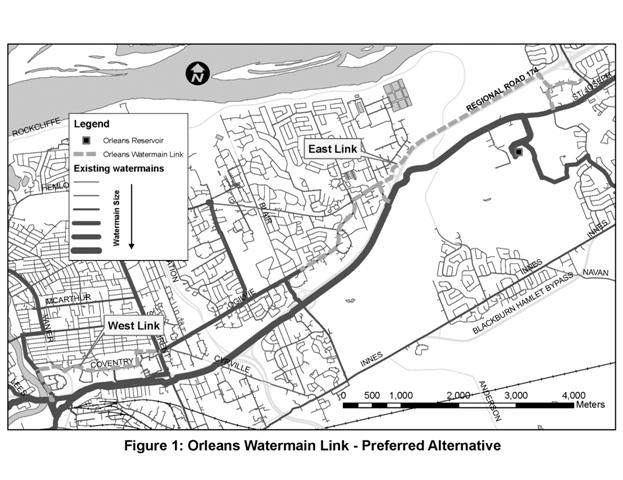
The preferred alternative (Document 2)
includes two components:
·
West Link – A new major watermain will extend
north from near Highway 417, in the vicinity of North River Road, cross RCMP
property to the Vanier Parkway, and then follow Coventry Road east to Saint
Laurent Boulevard. The North River Road
segment will replace an existing main in the same alignment; and
·
East Link – A new major watermain will extend
east from Ogilvie Road at Blair Road to Montreal Road, and then follow the
northern edge of the Highway 174 corridor into Orléans, via Youville Drive.
The proposed alignment intersects the National
Capital Commission (NCC) Greenbelt in the vicinity of Highway 174, the Royal Canadian
Mounted Police (RCMP) property on the Vanier Parkway, and the Hydro One property
on Youville Drive. The RCMP property is owned by Public Works and Government
Services Canada (PWGSC). Discussions
with these agencies are on-going, but formal approvals have yet to be
secured. The design and approvals
process may result in some adjustments to the proposed alignment.
Design of both the East and West Links
will be carried out in 2012 and 2013.
Construction of both links is expected to begin in 2013. Two short segments of the project are not
considered to be necessary in the short term, and are expected to be deferred
for several years. This includes the
North River Road segment, and a proposed interconnection between the OWL and
the existing main transmission line at Shefford Road.
The cost for the new OWL (East and West
Links) is estimated at $49 million. Because this new link is being
installed along an existing corridor, there is an opportunity to integrate
other infrastructure needs as part of the construction. This is mainly
the case for the West Link where Coventry Road will be reconstructed to address
existing road, watermain and sewer needs. The integrated needs for the
East Link are not anticipated to be significant. In total, the overall updated
integrated project cost is estimated at $75M,
which will be further refined through the design process later this year.
Funding for the East and West links
are identified in the 2012 Capital Budget under accounts 901141 (East) and
906635 (West). The total amount previously identified in the 2012 Capital
Budget for 2012-2015 to fund the overall integrated project was $50M ($15M for
the East link and $35M for the West link). The $25 million balance, to be
refined through the detailed design process, will be funded through WIP
closures, bulk allocations, the reallocation of priorities, project phasing,
debt financing, or a combination thereof.
The reasons for the rise in the
estimate for this project are multiple and relate to project-specific
challenges, including increases to the project’s scope, and construction
industry specific rapid inflation. Further, the original estimate was a
high-level planning estimate based on simple cost per metre calculations that
did not benefit from a project specific Environmental Assessment study or
subsequent functional design work.
For example, the functional design
work that was done as part of the EA process uncovered the need for two
additional watermain segments, both of which involve tunnelled highway
crossings, and difficult connections to the existing transmission system that
were not previously anticipated . One of these segments will interconnect
the OWL to the primary transmission main at Shefford Road. The other
segment will interconnect the two mains via Youville Drive and an easement
through Hydro One property. While these additional watermain segments are
critical to ensure operational performance, they have also added roughly $7 million
to the cost of the project. Furthermore, design work also identified
enhancements that were needed to cross Green’s Creek Valley that would limit
impacts on the Eastern Greenbelt and to better ensure NCC approvals for the
project. The cost of the creek crossing is expected to be high because of
some geotechnical conditions and the manner in which the creek bends near the
highway. In total, these enhancements added roughly another $7 million to
the estimate for the project.
Another reason for the rise in the
estimate for this project is the rapidly increasing cost of delivering these
types of infrastructure projects. For the last few years, the construction
price index has been roughly 3.5 per cent per annum, but costs associated with
this type of project have been rising faster than that. These factors affect
engineering, materials and construction costs. Furthermore, additional
construction contingency has been added to the overall project estimate due to additional
project challenges such as a major trunk gas main crossing near the eastern
edge of the Greenbelt.
In order to mitigate these estimated
cost increases, a value engineering review will be conducted as part of the detailed
design process in order to see if there are options to deliver these key pieces
of water infrastructure at a reduced cost.
The study documentation is provided in
the April 2012 OWL Environmental Assessment Study by Delcan Corporation (Document
1).
RURAL
IMPLICATIONS
There
are no rural implications associated with this report.
CONSULTATION
Consultation included the following
components:
- Notice
of commencement published in July 2011
- Communications
with Ward Councillors, Community and Business Associations, and various
agencies including the NCC
- Meetings
with the Convent Glen Community Association and the Overbrook Community
Association
- Householder
distributed to over 11,000 property addresses
- Project
web page, including a feedback form (Ottawa.ca/owl)
COMMENTS BY
THE WARD COUNCILLORS
Councillors of affected Wards (1, 2,
11, 13, 17, 19) are aware of the project.
LEGAL
IMPLICATIONS
There are no legal impediments to
implementing the recommendation in this report.
Once the Notice of Completion is published, the Study Report will be
subject to a 30‑day review period during which individuals may raise
concerns and request a Part II Order be issued by the Minister of Environment
to elevate the status of the project.
RISK
MANAGEMENT IMPLICATIONS
The project will substantially reduce
the risk of water supply interruptions and/or water restrictions in the East
Urban Community. The West Link of the
project is also needed to address risks posed by the construction of the OLRT project
and the widening of Highway 417.
FINANCIAL
IMPLICATIONS
As indicated in this report, the revised
estimated cost for this project is $75 million. A total of $50 million for the
project has been included in the City’s capital planning forecast (under two
projects: 901141 Orléans Transmission Main; and 906635 Hurdman-St.
Laurent Watermain Relocation). The $25 million balance, to be refined
through the detailed design process, will be funded through WIP closures, bulk
allocations, the reallocation of priorities, project phasing, debt financing,
or a combination thereof. Project estimates will be updated for the 2013 budget
process and any required additional capital authority and funding sources will
be brought forward for Council consideration at that time.
ACCESSIBILITY
IMPACT
The project has no
accessibility impacts.
ENVIRONMENTAL
IMPLICATIONS
The project has been subject to a
Schedule B Class Environmental Assessment.
Environmental impacts are expected to be limited, and mitigation
measures have been identified. The OWL
will cross the NCC Greenbelt immediately adjacent to Regional Road 174, and
thus will not have a significant impact on these lands.
TECHNOLOGY
IMPLICATIONS
There are no direct technical
implications associated with this report.
TERM OF
COUNCIL PRIORITIES
The project is consistent with the
long term sustainability goals for water and wastewater services. The project will improve operational
performance and reliability of service to residents and businesses, and will be
a key component to achieving service excellence.
SUPPORTING
DOCUMENTATION
DISPOSITION
Following Committee and Council
approval, the OWL Environmental Assessment Study report (Document 1), which
describes the entire environmental assessment process and study recommendations
will be made available to the public for a 30-day review period. The public
will be notified through the posting of a ‘Notice of Study Completion’ appearing in local daily newspapers and
the City’s website for this project. Additionally, the Notice will be forwarded
to the Study’s mailing list.