|
3. ZONING – 707 RIVER ROAD, 662 EARL
ARMSTRONG ROAD, PART OF 4650 SPRATT ROAD ZONAGE – 707, CHEMIN RIVER; 662, CHEMIN EARL
ARMSTRONG ET UNE PARTIE DU 4650, CHEMIN SPRATT |
Committee
recommendation
That Council
approve an amendment to the Zoning By-law 2008-250 to change the zoning of 707
River Road, 662 Earl Armstrong and part of 4650 Spratt Road from Development
Reserve (DR) to Residential Third Density Subzone Z, (R3Z) - Residential Third
Density Subzone Z exception xxxx with a holding provision (R3Z[xxxx] h),
Residential Fifth Density Subzone Z (R5Z), – General Mixed Use Zone (GM),-
Parks and Open Space Zone (O1) and - Minor Institutional Subzone A (I1A) as
shown in Document 1 and as detailed in Document 2.
Recommandation DU Comité
Que le Conseil approuve
une modification au Règlement de zonage 2008-250 afin de changer la désignation
de zonage du 707, chemin River, du 662, chemin Earl Armstrong et d’une partie
du 4650, chemin Spratt de Zone d’aménagement futur (DR) à Zone résidentielle de
densité trois, sous-zone Z (R3Z), Zone
résidentielle de densité 3, sous-zone Z assortie de l’exception xxxx et du
symbole d’aménagement différé (R3Z[xxxx] h), Zone résidentielle de densité
cinq, sous-zone Z (R5Z), Zone d’utilisations polyvalentes générale (GM), Zone
de parc et d’espace vert (O1) et Zone de petites institutions, sous-zone A
(I1A), comme il est indiqué dans le Document 1 et expliqué en détail dans le
Document 2.
Documentation
1.
Deputy City
Manager's report, Planning and Infrastructure, dated 20 January 2012 (ACS2012-PAI-PGM-0040).
Report to/Rapport au :
Comité
de l'urbanisme
and Council / et au Conseil
20 January 2012 / le 20 janvier 2012
Submitted by/Soumis par :
Nancy Schepers, Deputy City Manager/
Directrice municipale adjointe, Planning and
Infrastructure/Urbanisme et Infrastructure
Contact
Person/Personne-ressource : Derrick Moodie, Acting Manager/
Gestionnaire intérimaire, Development Review-Suburban
Services/Examen des projets d'aménagement-Services suburbains, Planning and
Growth Management/
Urbanisme et Gestion de la croissance
(613)
580-2424, 15134 Derrick.Moodie@ottawa.ca
|
SUBJECT: |
ZONING
– 707 River Road, 662 Earl Armstrong Road, part of 4650 Spratt Road |
|
|
|
|
OBJET : |
ZONAGE – 707, chemin river; 662, chemin
earl armstrong et une partie du 4650, chemin spratt |
REPORT RECOMMENDATION
That the Planning Committee
recommend Council approve an amendment to the Zoning By-law 2008-250 to change
the zoning of 707 River Road, 662 Earl Armstrong and part of 4650 Spratt Road
from Development Reserve (DR) to Residential Third Density Subzone Z, (R3Z) -
Residential Third Density Subzone Z exception xxxx with a holding provision
(R3Z[xxxx] h), Residential Fifth Density Subzone Z (R5Z), – General Mixed Use
Zone (GM),- Parks and Open Space Zone (O1) and - Minor Institutional Subzone A (I1A)
as shown in Document 1 and as detailed in Document 2.
RECOMMANDATION
DU RAPPORT
Que le Comité de recommande au
Conseil d’approuver une modification au Règlement de zonage 2008-250 afin de
changer la désignation de zonage du 707, chemin River, du 662, chemin Earl
Armstrong et d’une partie du 4650, chemin Spratt de Zone d’aménagement futur
(DR) à Zone résidentielle de densité trois, sous-zone Z (R3Z), Zone résidentielle de densité 3, sous-zone Z
assortie de l’exception xxxx et du symbole d’aménagement différé (R3Z[xxxx] h),
Zone résidentielle de densité cinq, sous-zone Z (R5Z), Zone d’utilisations
polyvalentes générale (GM), Zone de parc et d’espace vert (O1) et Zone de
petites institutions, sous-zone A (I1A), comme il est indiqué dans le Document
1 et expliqué en détail dans le Document 2.
BACKGROUND
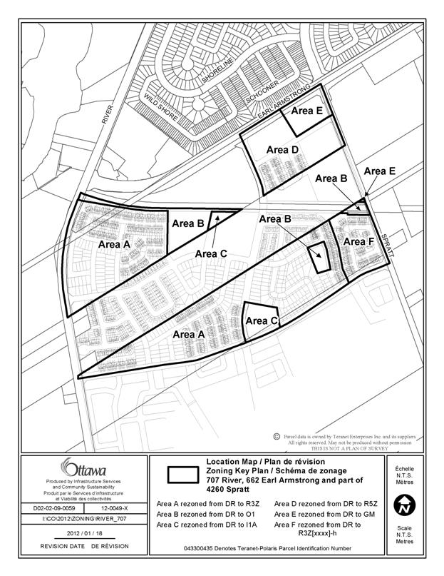
As shown in Document 1, the subject site is located to the south of Earl Armstrong Road between River Road and Spratt Road in the Riverside South Community. The lands are made up of three parcels which are know as 707 River Road, 662 Earl Armstrong Road and part of 4650 Spratt Road.
The overall block of lands owned by the Riverside South Development Corporation (RSDC) is bisected by lands being developed by Claridge Homes Inc. and the future transit corridor. To the north of the RSDC block and on the north side of Earl Armstrong Road, are an existing residential community and a commercial plaza. There is an existing Park and Ride Lot between 707 River Road and 662 Earl Armstrong Road on the south side of Earl Armstrong Road. To the east of Spratt Road, to the south of the new proposed collector road and to the west of River Road are vacant lands which are rural in nature but will be developed for residential purpose as set out in the Riverside South Community Design Plan in the future. The new Earl Armstrong-Strandherd Bridge is north and west of 707 River Road.
Purpose of Zoning Amendment
The proposed Zoning By-law Amendment is required to allow development of a fully serviced residential subdivision in the Riverside South Urban Area – Neighbourhood 2.
Existing Zoning
The existing zoning of the properties is DR, Development Reserve which recognizes lands that are intended for future urban development.
Proposed Zoning
The proposed zoning is Residential Third Density Subzone Z (R3Z), Residential Third Density Subzone Z exception xxxx with a holding provision (R3Z[xxxx]-h), Residential Fifth Density Subzone (R5Z), General Mixed Use Zone (GM), Parks and Open Space Zone (O1) and Minor Institutional Subzone (I1A). This zoning will permit an urban residential development of single detached dwellings, on-street townhouses and stacked townhouses to proceed. Other land uses that are part of this development are two institutional blocks, two park blocks, a mixed use block and a transit corridor block.
The transit corridor that bisects the site is to be zoned Parks and Open Space (O1).
The holding provision on a residential area located in the south east corner of Riverside South – Phase 9 abutting Spratt Road and the proposed transit corridor (Area F on the Location Map – Document 1) is necessary to ensure that, prior to the development of this residential neighbourhood, the Barrhaven – Riverside South Rapid Transit Planning and Environmental Study has been completed and that no additional lands are required for the BRT station along the Transitway at Spratt Road. If the Study determines that additional lands are required the holding symbol will be removed once the required lands have been conveyed to the City, at no cost.
DISCUSSION
Provincial Policy Statement
The Provincial Policy Statement (PPS) provides direction on matters of Provincial Interest related to land-use planning and development by promoting efficient land use patterns that support development of viable liveable communities. Contained within the policy statement are explicit policy objective that focus on growth in settlement areas, providing an appropriate range of housing with densities that efficiently use land resources (infrastructure and public service facilities), promoting public transit and other alternative transportation modes and creating healthy and active communities.
The proposed development is consistent with the objective and policies of the PPS and provides new residential development that makes efficient use of available and projected infrastructure services.
Official Plan
The Official Plan designates the
properties as General Urban with a Developing Community overlay. This designation permits the development of a
full range and choice of housing types to meet the needs of all, in combination
with conveniently located related uses such as leisure, retail, service and
institutional uses. The Developing Community overlay requires the completion of
a community design plan prior to any development being approved. The Riverside South Community Design Plan
(CDP) was approved in June 2005.
Subsequent to the completion of the
master servicing studies for the area, minor revisions were made to the
CDP. Council approved the update of the
Riverside South CDP on January 13, 2010. The CDP designates the subdivision
lands for Low, Medium and High Density Residential, a Community Park, a
Sub-Neighbourhood Park, an Elementary French Public School Block, Local
Commercial Block, an Institutional Block, a Recreational Multi-use Trail and
two Rapid Transit Stops. These
subdivision lands are bisected by a transit corridor owned by the City.
The subdivision application for 707 River Road,
662 Earl Armstrong Road and part of 4650 Spratt Road (D07-16-09-0014) received
Draft Approval on April 20, 2011. There
are 831 units proposed which can be further detailed as 182 singles, 445
townhouses and 204 stacked (apartment) units.
Details of Proposed Zoning
The applicant is requesting that the zoning for 707 River Road, 662 Earl Armstrong Road and part of 4650 Spratt Road be changed to R3Z, R3Z[xxxx] – h, R5Z, GM, O1 and I1A. The transit corridor is being zoned ‘O1’.
The R3Z zone will permit the development of the proposed single detached and row dwellings.
The R5Z zone will permit the development of the proposed stacked townhouses and low rise apartments.
The Z subzone establishes design elements that allow compact built form. The purpose is to permit different development standards primarily for areas designated as Development Communities to promote efficient land use. This design control brings the main entries to the houses closer to the street, and facilitates a more aesthetic streetscape.
The GM Zone will permit mixed uses at the two Local Commercial designated sites. These sites are to service the immediate residential by providing convenience shopping and services either as stand-alone use or combined with residential.
The two park blocks are to be zoned O1. This Parks and Open Space zone will permit a community park and a neighbourhood park.
The transit corridor is to be zoned O1 as this is the typical zone applied to transit corridors through the City and a rapid-transit network is permitted in all zones.
The school block and a block reserved for an institutional use (i.e. church) are to be zoned I1A. This is a Minor Institutional zone with a range of community uses which includes but is not limited to a school and a day care and the subzone A provides the zone provisions.
The use of the holding provision will ensure that development of a block of residential lands will not occur until the Barrhaven – Riverside South Rapid Transit Planning and Environmental Study has been completed and land requirements for the Spratt Road BRT Station have been determined. The exception provision sets out the condition that must be met to permit the holding symbol to be removed as follows:
1. The Barrhaven-Riverside South Rapid Transit Planning and Environmental Study is completed (anticipated for mid-2013); and
2. The land requirements for the future Rapid Transit Station at Spratt Road have been determined and conveyed at no cost to the City.
The applicant has agreed with the use of the holding provision.
Zoning Recommendation
Staff are satisfied that the proposed changes in the zoning of 707 River Road, 662 Earl Armstrong Road and part of 4650 Spratt Road to R3Z, R3Z[xxxx]-h, R5Z, GM, O1 and I1A is consistent with the policies of the Provincial Policy Statement, the Official Plan and the Riverside South CDP and recommend approval.
RURAL IMPLICATIONS
There are no rural implications associated with this report.
CONSULTATION
Notice of this application was carried out in accordance with the City's Public Notification and Consultation Policy. The City did not receive any negative comments or opposition to this application. One inquiry was received about the residential zoning and what was permitted in each of the R3Z and R5Z zones.
COMMENTS BY THE WARD COUNCILLOR
The Ward Councillor is aware of this application and staff’s recommendation.
LEGAL IMPLICATIONS
There are no legal implications associated with this report.
RISK MANAGEMENT IMPLICATIONS
There are no risk management implications association with the recommendation in this report.
FINANCIAL IMPLICATIONS
There are no financial implications associated with this report.
ACCESSIBILITY IMPACT
ENVIRONMENTAL IMPLICATIONS
There are no environment implications associated with this report.
TECHNOLOGY IMPLICATIONS
There are no direct technical implications associated with this report.
CITY STRATEGIC PLAN
Manage growth and create sustainable communities by:
· becoming leading edge in community and urban design;
· ensuring that new growth is integrated seamlessly with established communities; and
· ensuring that community facilities are built in tandem with new development.
Ensure that the City infrastructure required for new growth is built or improve as need to serve growth.
APPLICATION PROCESS TIMELINE STATUS
This application was processed by the "On Time Decision Date" established for the processing of Zoning By-law amendment applications.
SUPPORTING DOCUMENTATION
Document 1 Location Map
Document 2 Details of Recommended Zoning
DISPOSITION
City Clerk and Solicitor Department, Legislative Services to notify the owner, applicant, OttawaScene Canada Signs, 1565 Chatelain Avenue, Ottawa, ON K1Z 8B5, Ghislain Lamarche, Program Manager, Assessment, Financial Services Branch (Mail Code: 26-76) of City Council’s decision.
Planning and Growth Management to prepare the implementing by-law, forward to Legal Services and undertake the statutory notification.
Legal Services to forward the implementing by-law to City Council.
LOCATION MAP DOCUMENT
1
DETAILS OF RECOMMENDED ZONING DOCUMENT 2
Proposed
Changes to the Comprehensive Zoning By-law
- The
subject lands shown on Document 1 will be rezoned from DR- Development Reserve to
R3Z – Residential Third Density Subzone Z, R3Z[xxxx]-h -
Residential Third Density Subzone Z exception xxxx with a holding
provision, R5Z – Residential Fifth Density Subzone Z, GM – General Mixed
Use Zone, O1 - Parks and Open Space Zone and I1A - Minor Institutional
Subzone A.
2. Add exception to Section
239 with text similar in effect to the following:
Exception [xxxx]
a) in
Column II the text: “R3Z[xxxx]-h”, and
b) in Column IV the text: “-all uses until
the holding symbol is removed”, and
c) in Column V the text:
The holding symbol may not be
removed until:
(i) The Barrhaven-Riverside South Rapid Transit Planning and Environmental Study is completed (anticipated for mid-2013); and
(ii) The land requirements for the future Rapid Transit Station at Spratt Road have been determined and conveyed at no cost to the City to the satisfaction of the General Manager, Planning and Growth Management.