|
7. Land exchange – National Capital commission – Hunt Club, Ontario Highway 417 Interchange
échange DE TERRAINS AVEC LA Commission de la capitale nationale – éCHANGEUR DU CHEMIN Hunt-ClubET DE L'AUTOROUTE 417
|
COMMITTEE RECOMMENDATIONS
That Council:
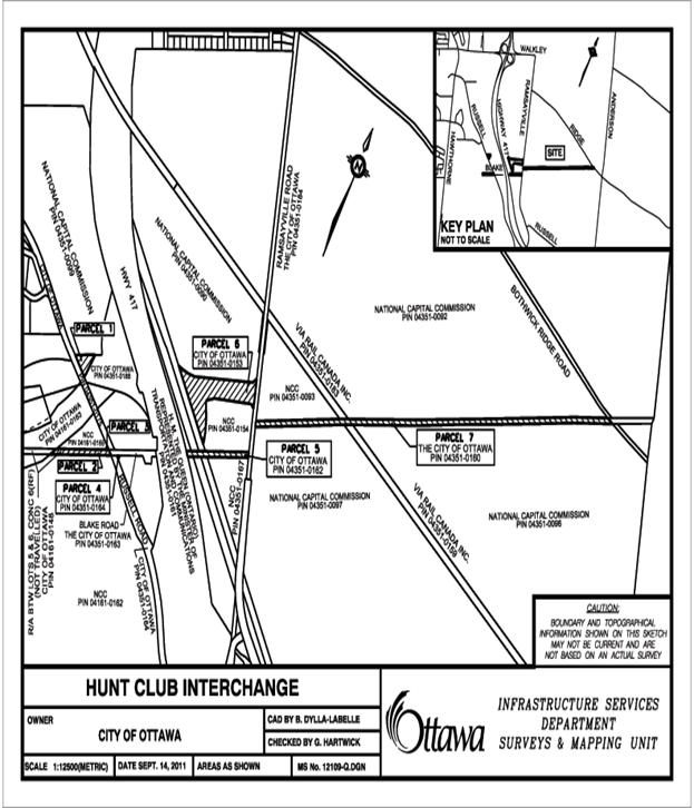
1. Declare the vacant non-viable lands described as Parts of Lot 5 Concessions 6 shown as Parcel 1 and 6 on Document 2 attached, and part of the road allowances between Lots 5 and 6, Concession 6 (R.F.), geographic Township of Gloucester now in the City of Ottawa and shown as Parcels 2, 3, 4, 5 and 7 on Document 2 attached, containing a total area of approximately 9.3 ha (22.98ac) subject to final survey and subject to the road allowances being closed by by-law and the properties being circulated in accordance with the Disposal Policy as surplus to the City’s needs; and
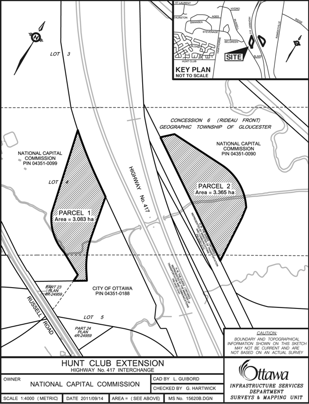
2. Approve the sale of the land referred to in Recommendation 1, having a market value of $584,800 together with a cash payment of $320,550 plus applicable taxes to the National Capital Commission in exchange for two parcels of vacant land containing an area of 6.45 ha (15.9 acres), subject to final survey and described as Parts of Lots 4 and 5, Concession 6 Rideau Front, geographic Township of Gloucester, shown as Parcels 1 and 2 on Document 1 attached, having a value of $905,350, subject to any easements that may be required pursuant to a Land Exchange Agreement that has been received.
RECOMMANDATIONS DU COMITÉ
Que le Conseil :
1. déclare excédentaires les terrains vacants non viabilisables décrits comme parties du lot 5, concession 6, et constituant les parcelles 1 et 6 dans le document 2 ci-joint, et comme partie des emprises routières entre les lots 5 et 6, concession 6 (façade rivière Rideau), canton géographique de Gloucester, maintenant dans la ville d'Ottawa, et constituant les parcelles 2, 3, 4, 5 et 7 dans le document 2 ci-joint, ayant une superficie totale d'environ 9,3 ha (22,98 acres), à préciser lors de l'arpentage final, sous réserve de la fermeture des emprises routière par voie de règlement municipal et des exigences de publicité foncière prévues par la politique sur l'aliénation des biens; et
2. approuve la vente des terrains décrits dans la recommandation 1, d'une valeur marchande de 584 800 $, et le versement d'une somme de 320 550 $, taxes en sus, à la Commission de la capitale nationale en échange de deux parcelles vacantes d'une valeur de 905 350 $ et d'une superficie de 6,45 ha (15,9 acres), à préciser lors de l'arpentage final, décrites comme parties des lots 4 et 5, concession 6, façade rivière Rideau, canton géographique de Gloucester, et constituant les parcelles 1 et 2 dans le document 1 ci-joint, conformément à la convention d'échange de terrains qui a été reçue et sous réserve de toute servitude éventuellement nécessaire.
1. City Manager’s report dated 21 December 2011 (ACS2012-CMR-REP-0001).
2. Extract of Finance and Economic Development Committee Minutes dated 12 January 2012.
Report to/Rapport au:
Finance and Economic Development Committee
Comité des finances et du développement économique
and Council / et au Conseil
21 December 2011 / 21 décembre 2011
Submitted by/Soumis par: Kent Kirkpatrick, City Manager / directeur municipal
Contact Person/Personne ressource: Robin Souchen, Manager, Realty Services Branch, Real Estate Partnerships and Development Office / Gestionnaire, Direction des services immobiliers, Bureau de partenaires immobiliers et du développement
(613) 580-2424 x 21549, Robin.Souchen@ottawa.
|
Ref N°:ACS2012-CMR-REP- 0001 |
REPORT RECOMMENDATIONS
That the Finance and Economic Development Committee recommend Council:
1. Declare the vacant non-viable lands described as Parts of Lot 5 Concessions 6 shown as Parcel 1 and 6 on Document 2 attached, and part of the road allowances between Lots 5 and 6, Concession 6 (R.F.), geographic Township of Gloucester now in the City of Ottawa and shown as Parcels 2, 3, 4, 5 and 7 on Document 2 attached, containing a total area of approximately 9.3 ha (22.98ac) subject to final survey and subject to the road allowances being closed by by-law and the properties being circulated in accordance with the Disposal Policy as surplus to the City’s needs; and
2. Approve the sale of the land referred to in Recommendation 1, having a market value of $584,800 together with a cash payment of $320,550 plus applicable taxes to the National Capital Commission in exchange for two parcels of vacant land containing an area of 6.45 ha (15.9 acres), subject to final survey and described as Parts of Lots 4 and 5, Concession 6 Rideau Front, geographic Township of Gloucester, shown as Parcels 1 and 2 on Document 1 attached, having a value of $905,350, subject to any easements that may be required pursuant to a Land Exchange Agreement that has been received.
RECOMMANDATIONS DU RAPPORT
Que le Comité des finances et du développement économique recommande au Conseil d’approuver ce qui suit :
1. Déclarer excédentaires les terrains vacants non viabilisables décrits comme parties du lot 5, concession 6, et constituant les parcelles 1 et 6 dans le document 2 ci-joint, et comme partie des emprises routières entre les lots 5 et 6, concession 6 (façade rivière Rideau), canton géographique de Gloucester, maintenant dans la ville d'Ottawa, et constituant les parcelles 2, 3, 4, 5 et 7 dans le document 2 ci-joint, ayant une superficie totale d'environ 9,3 ha (22,98 acres), à préciser lors de l'arpentage final, sous réserve de la fermeture des emprises routière par voie de règlement municipal et des exigences de publicité foncière prévues par la politique sur l'aliénation des biens; et
2. Approuver la vente des terrains décrits dans la recommandation 1, d'une valeur marchande de 584 800 $, et le versement d'une somme de 320 550 $, taxes en sus, à la Commission de la capitale nationale en échange de deux parcelles vacantes d'une valeur de 905 350 $ et d'une superficie de 6,45 ha (15,9 acres), à préciser lors de l'arpentage final, décrites comme parties des lots 4 et 5, concession 6, façade rivière Rideau, canton géographique de Gloucester, et constituant les parcelles 1 et 2 dans le document 1 ci-joint, conformément à la convention d'échange de terrains qui a été reçue et sous réserve de toute servitude éventuellement nécessaire.
BACKGROUND
In the 2001 Bridges Agreement between the City and the National Capital Commission (NCC), the City acquired a 3.2 ha (7.9 acres) strip of land to extend Hunt Club Road from Hawthorne Road to an interchange at Highway 417. The omnibus agreement settled several land issues between the NCC and the newly amalgamated City and included the property required for the Hunt Club Extension based on the 2001 design. The Hunt Club extension was subsequently redesigned to accommodate the McEwan Creek Stormwater Management Pond and to provide a better angle of approach to the highway interchange. The realignment required additional property from the NCC and some City property became surplus as a result of the new design.
On 19 January 2010 City Council approved funding for the extension of Hunt Club Road from Hawthorne Road to Russell Road as Phase 1 of the project as described in report ACS2010-CMR-REP-0003. The approval included funding for property requirements together with approval for disposal of the City land left surplus due to the new design. The initial project did not include the Highway 417 interchange as only the Hawthorne Road to Russell Road link was sufficiently designed to meet the “shovel ready” criteria of the available funding.
In the 2011 Capital Budget, City Council approved funding for the Phase 2 section of the Hunt Club, 417 Interchange Project to connect Hunt Club Road to Highway 417. The interchange has now been designed to the satisfaction of the NCC and the Ministry of Transportation Ontario and two parcels of land located on either side of Highway 417 shown as Parcels 1 and 2 on Document 1, are now required from the NCC for completion of the project.
DISCUSSION
In order to comply with NCC policy of no net loss of Greenbelt lands, the NCC requested that the property transaction be conducted as a land exchange. Negotiations proceeded on this basis with seven (7) parcels of land owned by the City identified as potential exchange lands, shown as Parcels 1 through 7 on Document 2 which contain a total land area of 93,138m2 (22.98 acres). Among these Parcels 1 and 6 on Document 2 are remnant parcels stemming from the earlier alignment of Hunt Club Road established right of way, whereas the remaining parcels identified are untravelled road allowances located in the general vicinity.
Negotiations for the acquisition were supported by an internal market valuation and an independent appraisal commissioned by the City to provide an estimate of market value for each of the subject properties in its respective highest and best use. For both NCC and City properties located west of Highway 417, highest and best use was based on light industrial use; whereas properties located east of Highway 417, highest and best use was based on agricultural use. The appraisers relied on the Direct Comparison Approach wherein the subject properties were compared with similar type properties that have recently been sold, or had been offered for sale at the time of the appraisal. The appraisers’ value estimate for the Industrial land was at $25 per square metre, whereas the estimate for the agricultural land was $4 per square metre.
Applying these rates to the City Parcels made up of remnant parcels stemming from the earlier alignment of Hunt Club Road (Parcels 1 and 6) together with untravelled road allowances in the general vicinity (Parcels 2, 3, 4, 5 and 7) negotiations resulted in a value of $584,820. With respect to the NCC lands identified as Parcels 1 and 2 on Document 1, applying the above rates resulted in a value of $905,350. As part of the agreement, the City agrees to pay the cash difference of the values, determined to be $320,550 ($905,350 - $584,820).
Calculations are as follows:
|
Document 1 |
Area m2 |
Value per m2 |
Parcel Value |
|
Parcel 1 |
30,830 |
$ 25.00 |
$ 770,750 |
|
Parcel 2 |
33,650 |
$ 4.00 |
$ 134,600 |
|
NCC land transfer to City |
|
Total Value |
$ 905,350 |
|
|
|
|
|
|
Document 2 |
Area m2 |
Value per m2 |
Parcel Value |
|
Parcel 1 |
4,032 |
$ 25.00 |
$ 100,800 |
|
Parcels 2 and 3 |
5,978 |
$ 25.00 |
$ 149,450 |
|
Parcel 4 |
98 |
$ 25.00 |
$ 2,450 |
|
Parcel 5 |
6,400 |
$ 4.00 |
$ 25,600 |
|
Parcel 6 |
35,650 |
$ 4.00 |
$ 142,600 |
|
Parcel 7 |
40,980 |
$ 4.00 |
$ 163,920 |
|
City land transfer to NCC |
|
Total Value |
$ 584,800 |
|
Cash difference Credit NCC |
|
|
$ 320,550 |
Should any parcel of City land be unavailable for exchange due to a claim stemming from the circulation, the City will pay the cash value of those parcels to the NCC.
The City requires timely access to the NCC lands in order to pre-load materials on the interchange ramps to be left for settlement and consolidation. To meet the construction schedule the initial work must proceed in early winter. However, the mandatory circulations and implementation of the road closing bylaw cannot be completed within the time allowed. To accommodate this schedule, the parties have entered into a Memorandum of Understanding (MOU) subject to the approval of City Council and the NCC Board whereby the NCC has agreed to issue a License of Occupation to the City to permit the preloading activities. The MOU was approved by Staff under Delegated Authority Report DEL2011-REPDO-0134.
The agreement to exchange the properties in question is considered fair and reasonable and is recommended for acceptance.
RURAL IMPLICATIONS
The lands conveyed to the NCC will offset the loss of Greenbelt lands used to complete the Hunt Club, Highway 417 interchange. There will be no net loss of NCC owned Greenbelt lands as a result of the land exchange.
CONSULTATION
In accordance with policies approved by City Council on 14 November 2001, the availability of the City properties in the exchange will be circulated to all City departments, including the Housing Branch, City Operations and Planning and Growth Management to determine if the Property is required for a City mandated program.
The Land Use and Natural Systems Unit of Planning and Growth Management were consulted with respect to the Natural Heritage System and Greenspace Master Plan and their comments are indicated under the Environmental Implications section of this report. Neither the Housing Branch nor any other City Departments expressed interest in retaining the property.
The utility companies were also circulated and there were no requirements for easements indicated.
The following Advisory Committees will also be circulated:
Local Architectural Conservation Advisory Committee (LACAC), Ottawa Forests and Greenspace Advisory Committee (OFGAC), Environmental Advisory Committee (EAC), Parks and Recreation Advisory Committee (PRAC) and Roads and Cycling Advisory Committee (RCAC).
COMMENTS BY THE WARD COUNCILLOR
The properties are located in Ward 10, Gloucester Southgate. Councillor Deans has reviewed and is aware of the report.
LEGAL IMPLICATIONS
There are no legal impediments to implementing any of the recommendations in this report.
RISK MANAGEMENT IMPLICATIONS
The land exchange is required to complete the Hunt Club Road / Highway 417 interchange. Failure to approve the land exchange will delay preloading of the interchange ramps leading to delay of the interchange construction.
FINANCIAL IMPLICATIONS
Upon approval, the City will draw the value of the NCC lands being $905,294.90 from account 903176 for payment to the NCC as a deposit for the License of Occupation. Upon conveyance of City lands to the NCC, account 903176 will be credited with $584,789.20.
Account number 903176
Approved Budget to Date $70,743,000
Total Paid and Committed ($50,119,498)
Balance Available $20,623,502
This Request ($ 362,222)
Balance Remaining $20,261,280
Funds have been provided in the 2010 Capital Budget and are available in Internal Order #903176. Funds reservation #11038947.
ACCESSIBILITY IMPACTS
There are no accessibility impacts associated with the project.
TECHNOLOGY IMPLICATIONS
There are no technological implications associated with the project.
CITY STRATEGIC PLAN
The City of Ottawa identified the need to provide a connection from the East Urban Community to the South Urban Community in its 2003 Transportation Master Plan. In 2004, the City initiated an Environmental Assessment for the Innes-Walkley-Hunt Club connection and Hunt Club Road/Highway 417 Interchange. The Hunt Club Road/417 interchange is a link in the connection of the East Urban and South Urban communities and corresponds with the City’s Strategic plan of a new infrastructure project that supports growth.
SUPPORTING DOCUMENTATION
Document 1: NCC lands to be conveyed to the City
Document 2: City Lands to be conveyed to the NCC
DISPOSITION
Following Council’s approval, the Real Estate Partnerships and Development Office and Legal Services Branch will finalize the transactions:
· Surveys and Mapping will provide Reference Plans; and
· Real Estate Services will complete the required Circulations and return to City Council for declaration of surplus property and for approval to convey the property to the NCC.
DOCUMENT 1
DOCUMENT 2