|
9. ZONING - 999 PINECREST ROAD ZONAGE – 999, CHEMIN PINECREST |
Committee
recommendation
(This matter is
Subject to Bill 51)
That Council
approve an amendment to Zoning By‑law 2008-250 to change the zoning of
999 Pinecrest Road from R1O [1564] to R2G as shown in Document 1.
Recommandation DU Comité
(Cette question est assujettie au Règlement 51)
Que le Conseil approuve
une modification au Règlement de zonage 2008-250 afin de changer la
désignation de zonage du 999, chemin Pinecrest de R1O [1564] à R2G, comme il
est indiqué dans le Document 1.
Documentation
1.
Deputy
City Manager's report, Infrastructure
Services and Community Sustainability, dated 18 November 2011 (ACS2011-ICS-PGM-0233).
Report to/Rapport au:
Comité de l'urbanisme
and Council / et au Conseil
18 November 2011 / le 18 novembre
2011
Submitted by/Soumis par :
Nancy Schepers, Deputy City Manager/Directrice
municipale adjointe, Infrastructure Services
and Community Sustainability/Services d’infrastructure et Viabilité des
collectivités
Contact Person/Personne-ressource : Derrick Moodie,
Acting Manager/Gestionnaire intérimaire, Development Review-Urban Services,
Outer Core/Examen des projets d'aménagement-Services urbains, Unité du Centre
extérieur
Planning and Growth Management/Urbanisme et Gestion de
la croissance
(613) 580-2424,
15134 Derrick.Moodie@ottawa.ca
|
SUBJECT: |
|
|
|
|
|
OBJET : |
REPORT RECOMMENDATION
That the Planning Committee recommend
Council approve an amendment to Zoning By‑law 2008-250 to change the
zoning of 999 Pinecrest Road from R1O [1564] to R2G as shown in Document 1.
RECOMMANDATION
DU RAPPORT
Que le Comité de
l’urbanisme recommande au Conseil d’approuver une modification au Règlement de
zonage 2008-250 afin de changer la désignation de zonage du 999, chemin
Pinecrest de R1O [1564] à R2G, comme il est indiqué dans le Document 1.
BACKGROUND
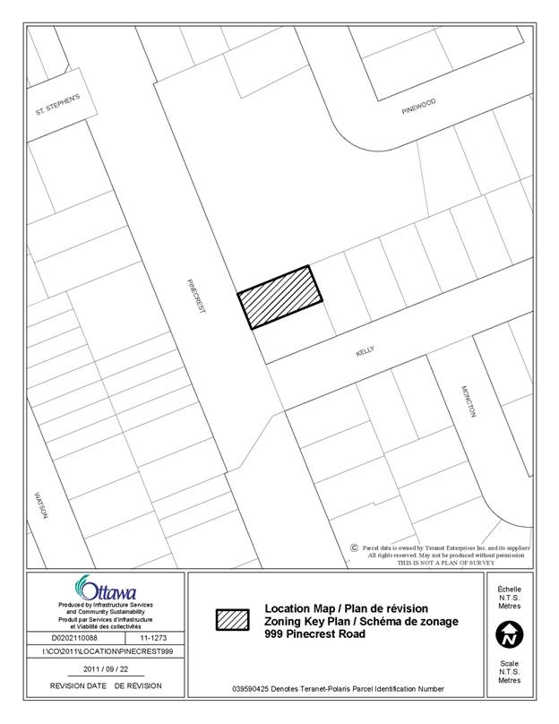
The subject property is located in the neighbourhood of Queensway Terrace North, which originally consisted of modern detached dwellings that are now being replaced with infill and redeveloped houses, mainly along Pinecrest Road. The property’s south and east edges abut residential uses. Its west edge fronts onto Pinecrest Road, including a bus stop and sidewalk. Its north edge abuts an institutional use, Britannia United Church.
The area of the subject property is approximately 0.05 hectares. The lot sits on relatively flat terrain consisting of shrubs, grass, and trees. The property is currently vacant. Access is off Pinecrest Road (see Document 1).
Purpose of Zoning Amendment
The Zoning By-law amendment proposes to rezone the subject lands to establish a residential zone that permits a variety of residential uses including duplex dwelling, semi-detached dwelling and linked-detached dwelling.
Existing Zoning
The subject property is located within the R1O[1564] – Residential First
Density Subzone O Special Exception 1564. This zone is prevalent throughout the
surrounding neighbourhood. A range of residential uses are permitted within the
R1 zone. The 1564 exception specifically
speaks to parking requirements restrictions. A semi-detached dwelling is not permitted
within the existing zone.
Proposed Zoning
It is proposed that the property be zoned R2G, which will permit the construction of a semi‑detached dwelling.
DISCUSSION
Planning Act
and Provincial Policy Statement
Section 2 of the Planning Act outlines those land use matters that are of provincial interest, to which all City planning decisions shall have regard. The provincial interests that apply to this site include the appropriate location of growth and development and the promotion of development that is designed to be sustainable to support public transit and to be oriented to pedestrians. In addition, the Planning Act requires that all City planning decisions be consistent with the Provincial Policy Statement (PPS), a document that provides further policies on matters of provincial interest related to land use development. PPS policies indicate that there should be an appropriate mix of uses and range of housing types and densities which efficiently use land, resources, infrastructure and public service facilities, and support the use of alternative transportation modes and public transit.
The proposed zoning allows for a mix of residential uses, which will efficiently use land and contribute to a balanced community. The site is conveniently located nearby residential and commercial areas to allow for access by pedestrians. The density of the proposal makes good use of existing urban lands, services, and infrastructure. Staff conclude that the proposal is consistent with the matters of provincial interest as outlined in the Planning Act and PPS.
Official Plan
Strategic Direction
Section 2 of the Official Plan sets broad strategic directions to meet the challenge of managing growth, providing infrastructure, maintaining environmental integrity and creating liveable communities within Ottawa. To meet these challenges, polices are set out to pursue a mix of land uses, housing types and compact forms of development which in turn will enable the City to support a high-quality transit system and make better use of existing infrastructure and roads. The proposed development provides a density that will support this overall goal.
Land Use Designation (Section 3.6.1)
The subject property is designated “General Urban Area” on Schedule B
of the Official Plan. The proposed use complies fully with the General Urban
area guidelines and requirements.
Compatibility (Section 2.5.1 and 4.11)
Section 2.5.1 of the Official Plan establishes design objectives which
describe the vision for the form of the City’s built environment. These
objectives are broadly stated and are applicable to all land use designations
either at the city-wide level or on a site-specific basis. Design principles
are further set out to describe how the City intends to achieve the design
objectives, with acknowledgment that all the design objectives may not be
achieved or be achievable in all cases.
The proposed development is consistent with and implements the design
objectives which speak to enhancing the sense of community, defining public and
private spaces through development, and having new development respect the
character of existing areas. An enhanced sense of community is being achieved
by infilling an underdeveloped site and strengthening the urban fabric of the
street physically and practically. Public and private spaces are being defined
through the establishment of a strong street edge and pedestrian environment.
The proposed new development respects the character of the existing area by
complementing the massing pattern, height, and character of the surrounding
context.
Details of Proposed Zoning
The Zoning By-law Amendment proposes to rezone the subject property
Residential Second Density Subzone G (R2G), which would permit the proposed
residential use. The details of the zoning amendment are contained in Document
3.
Conclusion
The proposed development supports the direction of the Planning Act and
Provincial Policy Statement by creating new development at densities and locations
that efficiently uses land, existing infrastructure and supports alternative
transportation. It represents an appropriate form of intensification, and is in
conformity with the policies in the Official Plan. Staff are satisfied that
suitability and compatibility of the proposed use and site have been adequately
considered in light of the relevant Official Plan policies.
The proposed Zoning By-law amendment conforms with the general intent of
the Official Plan and is compatible with the surrounding existing uses, and as
such, staff recommend its approval.
RURAL IMPLICATIONS
N/A
CONSULTATION
Notice of this application was carried out in accordance with the City's Public Notification and Consultation Policy. The City did not receive any negative comments or opposition to this application.
COMMENTS BY THE WARD COUNCILLOR
The Ward Councillor is aware of this application and the staff
recommendation.
LEGAL IMPLICATIONS
There are no legal
implications associated with this report.
RISK MANAGEMENT
IMPLICATIONS
N/A
FINANCIAL IMPLICATIONS
There are no direct financial implications associated
with this report.
ACCESSIBILITY IMPACT
The application is
consistent with the Planning and Growth Management priority which
APPLICATION PROCESS TIMELINE STATUS
This application was processed by the "On Time Decision Date" established for the processing of Zoning By-law amendment applications.
SUPPORTING DOCUMENTATION
Document 1 Location
Map
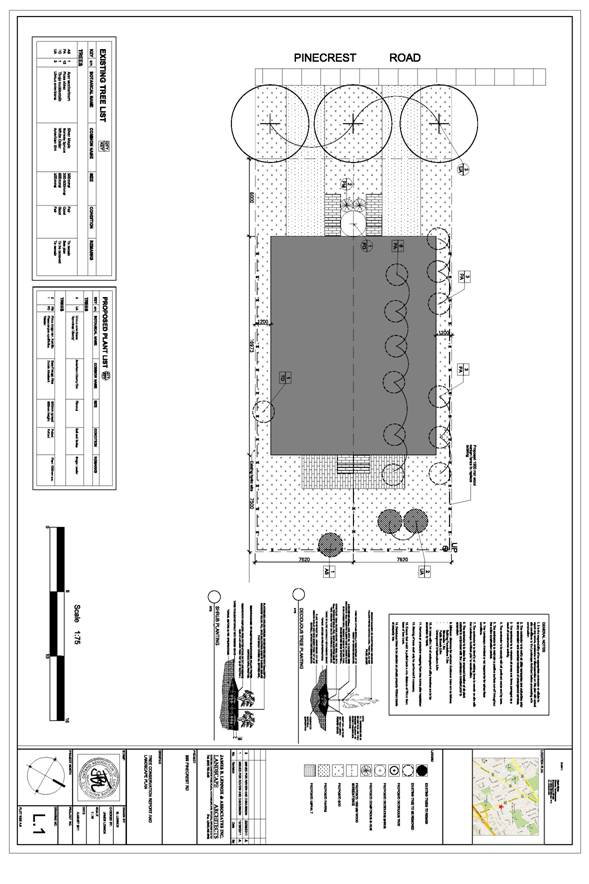
Document 2 Proposed
Site Plan
DISPOSITION
City Clerk and Solicitor Department, Legislative Services to notify the owner, applicant, OttawaScene Canada Signs, 1565 Chatelain Avenue, Ottawa, ON K1Z 8B5, Ghislain Lamarche, Program Manager, Assessment, Financial Services Branch (Mail Code: 26-76) of City Council’s decision.
Planning and Growth Management to prepare the implementing by-law, forward to Legal Services and undertake the statutory notification.
Legal Services to forward the implementing by-law to City Council.
LOCATION MAP DOCUMENT
1
PROPOSED SITE PLAN DOCUMENT
2