|
1.
ZONING – 3194 Diamondview
Road ZONAGE – 3194, Chemin Diamondview |
COMMITTEE
RECOMMENDATION
That Council
approve an amendment to the Zoning By-law 2008-250 to change the zoning of 3194
Diamondview Road from Rural Institutional Subzone 8 with exception (RI8[510r])
and Agricultural Subzone 1 (AG1) to Rural Residential Subzone 12 with exception
(RR12[XXXr] and to change the zoning of part of 3126 Diamondview Road from
Rural Institutional Subzone 8 with exception (RI8[510r]) to Agricultural
Subzone 1 (AG1) to correct the zoning boundary between these two properties as
is shown on Document 1 and detailed in Document 2.
RECOMMANDATION DU COMITÉ
Que le Conseil approuve une
modification au Règlement de zonage 250 (2008), de manière à faire passer le
zonage du 3194, chemin Diamondview de zone
d’institutions rurales, sous-zone 8 avec exception (RI8[510r]) et sous-zone
agricole 1 (AG1) à zone résidentielle rurale, sous-zone 12 avec exception
(RR12[XXXr], et à faire passer le zonage d’une partie
du 3126, chemin Diamondview de zone d’institutions
rurales, sous-zone 8 avec exception (RI8[510r]) à sous-zone agricole 1 (AG1),
en vue de corriger la limite de zonage séparant ces deux propriétés, tel
qu’illustré dans le document 1 et exposé en détail dans le document 2.
Documentation
1. Deputy City Manager’s
Report, Infrastructure Services and Community Sustainability, dated 14
September 2011 (ACS2011-ICS-PGM-0184).
2.
Extract of Draft Minutes, 4 November 2011.
Report
to/Rapport au :
Agriculture and Rural Affairs Committee
Comité de l'agriculture et des
affaires rurales
and Council / et au Conseil
14 September
2011 / le 14 septembre 2011
Submitted by/Soumis par :
Nancy Schepers, Deputy City Manager/Directrice
municipale adjointe, Infrastructure Services
and Community Sustainability/Services d’infrastructure et Viabilité des
collectivités
Contact
Person/Personne-ressource : Derrick Moodie, Manager/Gestionnaire, Development
Review-Rural Services/Examen des projets d'aménagement-Services ruraux,
Planning and Growth Management/Urbanisme et Gestion de la croissance
(613)
580-2424, 15134 Derrick.Moodie@ottawa.ca
|
SUBJECT: |
|
|
|
|
|
OBJET : |
REPORT RECOMMENDATION
That the Agriculture and Rural
Affairs Committee recommend Council approve an amendment to the Zoning By-law
2008-250 to change the zoning of 3194 Diamondview Road from Rural Institutional
Subzone 8 with exception (RI8[510r]) and Agricultural Subzone 1 (AG1) to Rural
Residential Subzone 12 with exception (RR12[XXXr] and to change the zoning of
part of 3126 Diamondview Road from Rural Institutional Subzone 8 with exception
(RI8[510r]) to Agricultural Subzone 1 (AG1) to correct the zoning boundary
between these two properties as is shown on Document 1 and detailed in Document
2.
RECOMMANDATION
DU RAPPORT
Que le Comité de l'agriculture et des affaires rurales recommande au Conseil d’approuver
une modification au Règlement de zonage 250 (2008), de manière à faire passer
le zonage du 3194, chemin Diamondview de zone
d’institutions rurales, sous-zone 8 avec exception (RI8[510r]) et sous-zone
agricole 1 (AG1) à zone résidentielle rurale, sous-zone 12 avec exception
(RR12[XXXr], et à faire passer le zonage d’une partie
du 3126, chemin Diamondview de zone d’institutions
rurales, sous-zone 8 avec exception (RI8[510r]) à sous-zone agricole 1 (AG1),
en vue de corriger la limite de zonage séparant ces deux propriétés, tel
qu’illustré dans le document 1 et exposé en détail dans le document 2.
BACKGROUND
The subject land is located on the east side of Diamondview Road, between Thomas Dolan Parkway and Baird Side Road. The subject property has an area of 756 square metres, with a frontage of 28 metres. There currently exists a 130 year old church on the site, which was abandoned 25 years ago. However, the church is not designated under Part IV of the Ontario Heritage Act. A well has recently been drilled but there is no septic service. The property is surrounded by agricultural uses to the north, south and east and by institutional and residential uses to the south-west. It is proposed that the existing church on the property be converted into a detached dwelling.
Purpose of Zoning Amendment
The proposal is to rezone the substantive
portion of the land to enable the owner to convert the church into a detached
dwelling. In addition, there is an error
of the actual property boundaries and the existing zoning boundary follows that
incorrect boundary. It is proposed that
the zoning boundary be corrected through this application.
Existing Zoning
The current zoning of the property is Rural
Institutional Subzone 8 - exception 510r "RI8[510r]"
(substantive part) and Agricultural Subzone 1 (AG1) under Zoning By-law
2008-250.
Proposed Zoning
The requested zoning amendment proposes to
rezone the substantive portion of the parcel from RI8[510r]
to Rural Residential Subzone 12 - exception "RR12[XXXr]"
to permit a detached dwelling. In
addition, to correct the zoning boundary a portion of property zoned AG1 is
proposed to also be rezoned to RR12[XXXr] and a portion zoned RI8[510r] is proposed to be
rezoned to AG1 (adjacent property where boundary has been in error).
DISCUSSION
Official Plan
The subject property is designated “Agricultural Resource Area” in Schedule A of the Official Plan.
As per policy 5.3 (2); irrespective of any other policy in the Official Plan, an individual has a right to develop a single-detached dwelling on a lot of record fronting on a public road that is maintained year round, if the lot was created under the Planning Act prior to the date of adoption of the Plan, if the zoning permits the use and if the use can meet all the requirements for private or central servicing.
Similarly, Section 3.7.3, states that a detached dwelling on a lot fronting on an existing public road is permitted and Section 4.4 states that a reliable supply of good quality water and the safe disposal of wastewater is an important consideration in the development review process. Proponents are required to demonstrate that the servicing proposed for the development is adequate.
As per section 4.6.1 (13), the heritage integrity of cemeteries will be given careful consideration at all times.
The subject property is an existing lot and the Official Plan gives direction allowing existing lots to be developed. The subject property is currently zoned Rural Institutional which allowed the church use to exist. The church was abandoned as a place of worship and subsequently sold. It is not likely that an institutional use would be reasonable anymore at this location. The Zoning By-law currently would allow an ancillary dwelling unit along with the church, which is more intensive than having just a dwelling unit in the church building. In addition, the property owner has demonstrated that the site can be fully serviced with the receipt of a septic permit, well certificate and water test.
Although it can be demonstrated that the church building has historical significance, the subject property has not been designated under Part IV of the Ontario Heritage Act. However, the property owner is planning on restoring the church and not putting an addition on it. The City is in support of this, especially considering that the building has been abandoned for so many years and could be replaced with a different building. Also, due to the building being restored rather than replaced, there is not considered to be cultural heritage impact on the cemetery across the road.
Details of Proposed Zoning
The subject property is currently zoned Rural Institutional Subzone 8 with exception (RI 8[510r]) and Agricultural Subzone 1 (AG1). The RI 8[510r] zone allows a place of worship and would also permit an ancillary dwelling unit. The exception permits a minimum lot area of 450 square meters and a minimum lot width of 15 meters, where normally a minimum of 1000 square meters of area and 30 meters for a minimum lot width would be permitted. Because of an error of the property boundaries, a portion of the property is also zoned AG1 which should be corrected by reflecting the zoning of the substantive portion of the property and similarly a portion of the abutting neighbour’s lands needs to be rezoned from RI8[510r] to AG1.
The applicant has requested that their property be rezoned Rural Residential Subzone 12 with an exception (RR 12[xxxr]). The RR 12 subzone reflects the minimum size of a rural lot to be 1000 square meters, which is the smallest of all the Rural Residential Subzones. However, the lot is currently 755.9 square meters with a portion of the lot to be conveyed to the City at some point in the future. In addition to an exception for lot size, an exception for the front and rear yards would also be necessary. The front yard setback of the church is 4.97 meters and the rear yard setback is 2.77 meters. The width of the lot, building height, side yards and maximum lot coverage that exist today conform to the RR12 zone.
ENVIRONMENTAL IMPLICATIONS
The impact of the rezoning application is viewed as negligible.
RURAL IMPLICATIONS
Currently the existing building and property is in need of repair and upkeep. The applicant proposes to restore the outside of the building to its previous condition, and retrofitting the inside of the building to function as a dwelling unit, enhancing the property and the rural area.
CONSULTATION
Notice of this application was carried out in accordance with the City's Public Notification and Consultation Policy.
A petition was received from 13 concerned members of the public and additional comments from two people were received separately. A summary of those comments is provided in Document 3.
COMMENTS BY THE WARD COUNCILLOR
Councillor Eli El-Chantiry is aware of the application.
LEGAL IMPLICATIONS
Should Committee and Council adopt the recommendation and an appeal be filed, it is estimated that a two day hearing would result, which could be conducted within staff resources. If the application is refused, then reasons must be provided. If the refusal were appealed to the Ontario Municipal Board an outside planner would need to be retained at an estimated cost of $15,000 to $20,000.
RISK MANAGEMENT IMPLICATIONS
N/A
CITY STRATEGIC PLAN
N/A
TECHNICAL IMPLICATIONS
FINANCIAL IMPLICATIONS
Potential costs are outlined in the Legal Implications section above. Should the services of an external planner be required, funds ($15,000 to $20,000) are not available within existing budget, and the expense may impact Planning and Growth Management’s operating budget status.
APPLICATION PROCESS TIMELINE STATUS
This application was processed by the "On Time Decision Date" established for the processing of Zoning By-law amendment applications.
SUPPORTING DOCUMENTATION
Document 1 Location Map
Document 2 Details of Recommended Zoning
Document 3 Consultation Details
DISPOSITION
City Clerk and Solicitor Department, Legislative Services to notify the owner, applicant, OttawaScene.com, 174 Colonnade Road, Unit #33, Ottawa, ON K2E 7J5, Ghislain Lamarche, Program Manager, Assessment, Financial Services Branch (Mail Code: 26-76) of City Council’s decision.
Planning and Growth Management to prepare the implementing by-law, forward to Legal Services and undertake the statutory notification.
Legal Services to forward the implementing by-law to City Council.
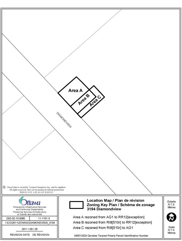
DOCUMENT 1
LOCATION MAP
DOCUMENT 2
DETAILS OF RECOMMENDED ZONING
Proposed
Changes to the Comprehensive Zoning By-law:
- Rezone the lands shown on Document 1 as follows:
- Area A from AG1 to RR12[XXXr];
- Area B from RI8[510r] to RR12[XXXr]; and,
- Area C from RI8[510r] to AG1.
- Add a new exception, RR12[XXXr], to Section 240 – Rural Exceptions with provisions similar in effect to the following:
Minimum lot area of 750 square meters
Minimum front yard setback 4.9 meters
Minimum rear yard setback 2.7 meters
DOCUMENT 3
CONSULTATION DETAILS
NOTIFICATION AND CONSULTATION PROCESS
Notification and public consultation was undertaken in accordance with the Public Notification and Public Consultation Policy approved by City Council for Zoning By-law amendments.
SUMMARY OF PUBLIC COMMENTS
Comments regarding the rezoning can be summarized as follows:
1) Well is too close to active farmland. Well will infringe on agricultural rights of the adjacent property owner.
2) Lot is too small and not in keeping with the rural area.
3) Front door too close to road for traffic if children or animals live there.
4) Property too close to farming operation, particularly large machinery.
5) Lot too small to service with well and septic. In addition, septic is too close to the drain (past the north corner of the lot).
6) Architectural changes do not respect heritage value of the building.
7) Against how property owners went ahead with works before approvals were granted. Interior and Exterior alterations and tree removal done before any approvals or applications submitted. Also, solar panels installed on roof.
8) Boundary of property is disputed.
9) Requesting a rezoning of more than just the existing property.
10) Disrespect to the original deed from 1886, which states “for use of a church…and for not other use or purpose whatsoever.” Land should have reverted to the Hodgins family following secularization of the church in 1992.
11) Precedent to allowing the loss of prime agricultural land.
12) Will impact property values of lots in close proximity.
13) Rezoning should be conditional on the erection by the residential owner of appropriate and secure residential fencing.
Staff Response
1) A well needs to respect a setback of 15 meters from a source of contamination such as from septic systems, manure storage facilities, etc., but no setback is required from a regular farming field.
2) 3) and 4) Although undersized, the lot is in existence and developed with a church on it. An ancillary dwelling unit is permitted on the property currently. Allowing a residential use within the church does not change the right of the property owner to be able to dwell on the property, only to allow that use to be within the existing building.
5) It has been demonstrated that the lot can be serviced, with the property owner receiving a septic permit, well certificate and water test.
6) The building is not on the heritage reference list. However, it is the property owner’s intention to restore the building, and an addition is not proposed.
7) This
rezoning application was brought forward to correct a situation where the
development of a dwelling unit was not conforming to the Zoning By-law. Although some works have begun, the use has
not yet occurred. This rezoning
application is being reviewed in terms of its appropriateness, regardless of
activities that have occurred. An Order To Comply (OTC) was issued in November of 2010 as a result
of the owner commencing construction and partial demolition prior to issuance
of a building permit. At the time the
construction occurred, Building Code Services did not require building permits
for photo voltaic solar panels. The owner ceased all related works and
the building inspector has continued to monitor the site in the interim.
All construction commenced prior to permit issuance will be subject to review
and inspection as prescribed by the Ontario Building Code upon permit issuance.
Tree removal on private property does not require any approval in the rural
areas.
8) 9) and 10) The property description based upon Plan 4R-24092 has been accepted in the Land Titles System. The abutting landowner does not dispute these boundaries. Reference Plan 4R-24092 is the most recent survey prepared by the previous owner, and replaces the original deed listed as FY2770. An error in the boundary exists on the City’s system and the existing zoning boundary also reflects that error. The approval of the recommendation for this application will correct that error.
11) There is no loss in agricultural lands as the property was identified improperly but has been out of agricultural production since it was given to the church 130 years ago.
12) There is no evidence to support the claims related to decreased property values.
13) Issues between owners exist irrespective of this rezoning application. The City does not require fencing as a condition of rezoning under these circumstances.
COMMUNITY ORGANIZATION COMMENTS
The March Rural Community Association and the Galetta Community Association are aware of the application.