|
4.
ZONING – part of
6622 Bank Street ZONAGE – partie du 6622,
rue bank |
COMMITTEE
RECOMMENDATION
That Council approve an amendment to the Zoning By-law 2008-250 to
change the zoning of a part of 6622 Bank Street from RH3[21r] to RH3[XXXr]-h
and RH3[XXYr]-h, as shown on Document 1 and as detailed in Document 2.
RECOMMANDATION DU COMITÉ
Que le Conseil
approuve une modification au Règlement de zonage 2008-250 afin de changer le
zonage d’une partie du 6622, rue Bank de RH3[21r] à RH3[XXXr]-h et RH3[XXYr]-h, comme il
est indiqué dans le Document 1 et expliqué en détail dans le Document 2.
Documentation
1. Deputy City Manager’s Report, Infrastructure
Services and Community Sustainability, dated 19 August 2011 (ACS2011-ICS-PGM-0171).
Report to/Rapport au :
Agriculture and Rural Affairs Committee
Comité de l'agriculture et des
affaires rurales
and Council / et au Conseil
19 August 2011 / le 19 août 2011
Submitted by/Soumis par :
Nancy Schepers, Deputy City Manager/Directrice
municipale adjointe, Infrastructure Services
and Community Sustainability/Services d’infrastructure et Viabilité des
collectivités
Contact
Person/Personne-ressource : Derrick Moodie, Manager/Gestionnaire, Development
Review-Rural Services/Examen des projets d'aménagement-Services ruraux,
Planning and Growth Management/Urbanisme et Gestion de la croissance
(613)
580-2424, 15134 Derrick.Moodie@ottawa.ca
|
SUBJECT: |
|
|
|
|
|
OBJET : |
REPORT RECOMMENDATION
That the Agriculture
and Rural Affairs Committee recommend Council approve an amendment to the
Zoning By-law 2008-250 to change the zoning of a part of 6622 Bank Street from
RH3[21r] to RH3[XXXr]-h and RH3[XXYr]-h, as shown on Document 1 and as detailed
in Document 2.
RECOMMANDATION
DU RAPPORT
Que le Comité de l'agriculture
et des affaires rurales recommande au Conseil d’approuver une modification au
Règlement de zonage 2008-250 afin de changer le zonage d’une partie du 6622,
rue Bank de RH3[21r]
à RH3[XXXr]-h et RH3[XXYr]-h, comme il est indiqué dans le Document 1 et
expliqué en détail dans le Document 2.
BACKGROUND
The subject property, 6622 Bank Street, is located on the west side of Bank Street, south of the Greely Village boundary. The total site area is comprised of approximately 18.4 hectares, with approximately 421 metres of frontage along Bank Street and, on the western limits, approximately 295 metres of frontage on Grey’s Creek Road.
The majority of the site is vacant with one single detached dwelling
fronting onto Bank Street. Land to the
east of the property contains a mixture of residential and commercial uses as
well as vacant land. The Greely Quarry
is located further to the east of the subject lands, approximately 385 metres
away. Land to the south contains an automobile
parts salvage business. Land to the
north contains residential uses. The wooded
south-central portion of the site and the area to the south and west of the
site contains woodland as well as a northeast portion of the Osgoode Swamp
Natural Area.
Purpose of Zoning Amendment
On December 16, 2010, the Committee of Adjustment granted provisional consent for a proposed severance of the subject property (D08-01-10/B-00332-B00334). The applicant wishes to subdivide the property into four separate parcels in order to create three new lots for industrial use. One of the conditions of the consent application was that the lands proposed to be severed be rezoned to remove the zoning exception [21r], with all levels of appeal exhausted prior to the lapse of consent.
Existing Zoning
The eastern half of the property is zoned RH3[21r] (Rural Heavy Industrial Zone, Subzone 3, with an exception. The RH3[21r] zone provisions permit a range of heavy industrial uses and limited service commercial uses on parcels with a minimum lot area of 1,000 m2 and minimum lot width of 30.0 metres. Exception 21r which is tied to the area of the site zone RH3, permits detached dwellings as an additional use, and such detached dwellings must be accessory to the permitted use. The three severed lots comply with the required RH3[21r] zone provisions as they are all in excess of 1000 m2 in area, and have lot widths greater than 30 metres.
The western half of the property is
zoned RU (Rural Countryside). The RU
zone permits a range of rural-based land uses as well as country residential
lots created by severance. The RU zone
provisions require a minimum lot area of 2 hectares with a minimum lot width of
60 metres for agricultural use. The
retained parcel is vacant, and will have a lot area of 7.2 hectares with a lot
width of 295 metres. The retained parcel
meets the requirements of the RU zone. The portion zoned RU is not subject to a
zoning amendment.
Proposed Zoning
The details of the recommended zoning are
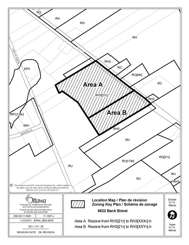
outlined in Document 2. Area A is
proposed to be rezoned to RH3[XXXr]-h.
Area B is proposed to be rezoned to RH3[XXYr]-h. The requirements for lifting the holding provision
are the same for Area A and Area B with the one exception that the
Environmental Impact Statement prepared for Area A must address the cultural
meadow and the potential to support bobolink habitat on that portion of the
site (a threatened species under the Endangered
Species Act).
DISCUSSION
Planning Act
Section 2 of the Planning Act requires municipalities to have regard for matters of provincial interest when carrying out their responsibilities under the Act. Matters of provincial interest that are relevant to this amendment are a) the protection of ecological systems, including natural areas, features and functions; b) ensuring individual on-site sewage and water systems are provided in a manner that protects human health and the environment; and c) the protection of mineral aggregate operations from development and activities that would preclude or hinder their expansion or continued use.
Section 3(5) of the Planning Act requires that the decision of a municipal Council shall be consistent with the policies of the Provincial Policy Statement (PPS). Section 2.1 of the PPS includes policies that require the protection of natural heritage features and areas for the long term. The policies do not permit development in significant habitat of endangered or threatened species unless it has been demonstrated that there will be no negative impacts on the natural features or on their ecological functions.
Official Plan
The Official Plan designates the subject site as General Rural Area. The intent of the designation is to accommodate a variety of land uses appropriate to a rural location. The property is located within 500 metres of an area designated Limestone Resource Area. An existing quarry is located approximately 385 metres to the east of the site. In accordance with Section 3.7.4 of the Official Plan, an Aggregate Impact Assessment study was prepared in support of the severance application which demonstrated that the proposed severance will not conflict with future mineral aggregate extraction nor will the mineral extraction operation be affected by the proposed lot severance.
The subject lands are also located
within 120 metres of the boundary of an area designated Rural Natural Feature
and Significant Wetland, located to the south and west of the site. In addition, the wooded south-central portion
of the site is identified as containing potentially significant woodlands and a
northeast portion of the Osgoode Swamp Natural Area is to the west of the site,
west of Grey’s Creek Road.
In accordance with Section 3.2.4
of the Official Plan, an Environmental Impact Statement was prepared in support
of the proposed severance which demonstrated that there will be no negative
impacts on the features.
Details of Proposed Zoning
The Rural Heavy Industrial Zone, Subzone 3 of the Zoning By-law allows for a variety of light and heavy industrial uses on the property. Removal of the exception which allows for a detached dwelling to be constructed as accessory to the permitted use is appropriate and reasonable as residential uses are not compatible in an industrial zone. In addition, a holding provision will be placed on Area A and Area B. Conditions are required prior to an application to lift the holding provision. The first condition is the completion of an Environmental Impact Statement (EIS) and the second is the completion of a Hydrogeological Assessment and Terrain Analysis. The only difference between the holding for Area A and Area B is that the EIS for Area A will require the assessment of the cultural meadow on the property and its potential to support the habitat for bobolink, a threatened species under the Endangered Species Act.
Servicing Issues
Staff as well as South Nation Conservation Authority staff requested that the Committee of Adjustment include a condition requiring the Owner to submit a hydrogeological evaluation and terrain analysis as part of the proposed severance application. The Committee felt that a standard condition requiring the Owners to drill a well or enter into an agreement with the City to drill the well at a later time would be appropriate. A hydrogeological assessment was again requested by staff when the application for the Zoning By-law amendment was circulated.
Since a hydrogeological assessment was not carried out to assess the suitability of the proposed lots to support industrial development on private services, a holding provision is being placed on the zoning of the lands. The holding provision will require that an assessment be undertaken as part of new development and will not be lifted until a Hydrogeological Assessment and Terrain Analysis has been approved by the City.
Mineral Resource Issues
An existing licensed quarry is located
approximately 385 metres to the east of the site. The mineral resource, known as Greely Quarry,
is owned and operated by Cornwall Sand and Gravel Ltd. (License No. 4075). As part of the application for consent, a
Mineral Impact Assessment was prepared.
In the context of the consent proposal, the assessment looked at
potential impacts on the resource and/or operation as a result of the severance
in addition to possible impacts of the mineral resource on the proposed land
use as a result of the severance. The
Mineral Impact Assessment and accompanying Addendum report concluded that the
proposed severance will not have any effect on the mineral resource operation
or its future expansion. Similarly, the
current quarry operation and any future expansion will not have any effect on
the newly created rural heavy industrial lots.
The potential construction of new wells in the projected area of
influence of the quarry will have to take into account the proximity of the
mineral extraction operation in order to yield sufficient quality and quantity
parameters. This will be addressed as
part of the Hydrogeological Assessment and Terrain Analysis.
RURAL IMPLICATIONS
Development of the subject lands would not be permitted until the holding symbol is removed. Removal of the holding symbol would not be possible without confirmation of the potential impacts to environmental features and that future industrial development can be supported on private services.
CONSULTATION
Notice of this application was carried out in accordance with the City's Public Notification and Consultation Policy.
Comments were received by the public. Detailed responses to the notification/circulation are provided in Document 3.
COMMENTS BY THE WARD COUNCILLOR(S)
The Ward Councillor is aware of the amendment and the staff recommendation.
LEGAL IMPLICATIONS
There are
no legal implications associated with this report.
RISK MANAGEMENT IMPLICATIONS
N/A
FINANCIAL IMPLICATIONS
There are no direct financial implications associated
with this report.
ENVIRONMENTAL
IMPLICATIONS
An Environmental Impact Statement (EIS)
was prepared in support of the proposed severance. The EIS was peer reviewed by South Nation
Conservation. The EIS concluded that
there will be no negative impacts on the natural features or on their
ecological functions as a result of the proposed severance. However, the recommendations contained
generalized statements about standard mitigation measures. The report states that “more detailed
mitigative measures be provided once lot specific development plans are
identified”. Therefore, as part of new development in Area A and Area B,
an assessment of the potential for the site to support significant woodlands or
wetlands must be performed. It is also necessary
that the future lot purchasers be informed of their obligation to implement
site specific tree saving measures.
In addition, Area A contains a large cultural
meadow that could provide suitable habitat for bobolink, which has been listed
as a threatened species under the Endangered
Species Act. Therefore, a bobolink
habitat assessment will be required as part of the site specific EIS. The
EIS prepared for the severance did not address bobolink habitat as its status
had not yet changed when the report was prepared.
TECHNOLOGY IMPLICATIONS
CITY STRATEGIC PLAN
The staff recommendation support policies in Section 2.4.2 regarding Natural Features and Functions. These policies direct that significant habitat of endangered or threatened species should be protected.
APPLICATION PROCESS TIMELINE STATUS
The application was not processed by the "On Time Decision Date" established for the processing of Zoning By-law amendments due to issues related to servicing the newly created lots on private services.
SUPPORTING DOCUMENTATION
Document 1 Location Map
Document 2 Details of Recommended Zoning
Document 3 Consultation Details
DISPOSITION
City Clerk and Solicitor Department, Legislative Services to notify the owner, applicant, OttawaScene Canada Signs, 1565 Chatelain Avenue, Ottawa, ON K1Z 8B5, Ghislain Lamarche, Program Manager, Assessment, Financial Services Branch (Mail Code: 26-76) of City Council’s decision.
Planning and Growth Management to prepare the implementing by-law, forward to Legal Services and undertake the statutory notification.
Legal Services to forward the implementing by-law to City Council.
LOCATION MAP DOCUMENT
1
DETAILS OF RECOMMENDED ZONING DOCUMENT 2
Proposed Changes to the Comprehensive Zoning By-law
1. The subject property as shown in Document 1 will be rezoned as follows:
a. Area A from RH3[21r] to RH3[XXXr]-h; and
b. Area B from RH3[21r] to RH3[XXYr]-h
2.
Add
a new exception, RH3[XXXr]-h, to Section 240-Rural Exceptions, including
provisions similar in effect to the following:
In Column II the text “RH3[XXXr]-h”;
In Column IV the text “- all uses until the holding
symbol is removed”; and,
In Column V the text:
The holding symbol may only be removed upon completion of the following:
(a) The City has approved an Environmental Impact Statement submitted in support of new development which demonstrates to the satisfaction of the General Manager, Planning and Growth Management that:
a. the site does not provide significant habitat for bobolink, a threatened species under the Endangered Species Act, nor contain significant wetlands or woodlands; and,
b. address site specific mitigative measures that are required as part of new development.
(b) The City has approved a Hydrogeological Assessment and Terrain Analysis, using the Ministry of Environment D-5-4 and D-5-5 guidelines, demonstrating to the satisfaction of the General Manager, Planning and Growth Management that the proposed development can be supported on private services.
(c) The Owner has constructed a well and provided a report demonstrating the adequacy of the aquifer with respect to quality and quantity to support the proposed development. The report must provide certification of the following to the City:
a. That a well has been constructed in accordance with the Ministry of Environment requirements;
b. That the quality of the water meets the Ministry of Environment Regulations, Standards, Guidelines and Objectives;
c. That there is sufficient quantity for the intended use.
d. All certifications must be provided by a qualified Professional Engineer, or Professional Geoscientist. All wells shall be certified in accordance with the Osgoode Well Compliance By-law 37-98, or as superseded by any City of Ottawa well inspection program in effect at the time of well certification
3.
Add
a new exception, RH3[XXYr]-h, to Section 240-Rural Exceptions, including
provisions similar in effect to the following:
In Column II the text “RH3[XXYr]-h”;
In Column IV the text “- all uses until the holding
symbol is removed”; and,
In Column V the text:
The holding symbol may only be removed upon completion of the following:
(a) The City has approved an Environmental Impact Statement submitted in support of new development which demonstrates to the satisfaction of the General Manager, Planning and Growth Management that:
a. the site does not contain significant wetlands or woodlands; and,
b. address site specific mitigative measures that are required as part of new development.
(b) The City has approved a Hydrogeological Assessment and Terrain Analysis, using the Ministry of Environment D-5-4 and D-5-5 guidelines, demonstrating to the satisfaction of the General Manager, Planning and Growth Management that the proposed development can be supported on private services.
(c) The Owner has constructed a well and provided a report demonstrating the adequacy of the aquifer with respect to quality and quantity to support the proposed development. The report must provide certification of the following to the City:
a. That a well has been constructed in accordance with the Ministry of Environment requirements;
b. That the quality of the water meets the Ministry of Environment Regulations, Standards, Guidelines and Objectives;
c. That there is sufficient quantity for the intended use.
d. All certifications must be provided by a qualified Professional Engineer, or Professional Geoscientist. All wells shall be certified in accordance with the Osgoode Well Compliance By-law 37-98, or as superseded by any City of Ottawa well inspection program in effect at the time of well certification
CONSULTATION DETAILS DOCUMENT
3
NOTIFICATION AND CONSULTATION PROCESS
Notification and public consultation was undertaken in accordance with the Public Notification and Public Consultation Policy approved by City Council for Zoning By-law amendments.
PUBLIC COMMENTS
There were two comments received from the public.
Comment: Along Bank Street, more and more residential and industrial development is coming this way. The Findlay Park residential and shopping area is expanding, and there are new housing and office complexes coming on Parkway and Bank. The residential and industrial (heavy rural industrial uses) areas are getting closer and closer to each other, and could easily lead to friction. So my comment is for city planners to perhaps consider some kind of fencing to border the properties for industrial use on Bank Street. It would cut down on the “ugliness” of the big trucks, heavy equipment, etc. lining the edges of Bank Street (my apologies to those business owners), and may even lessen vandalism. I really have no objection to the Michel Charron property but some kind of fencing for this and other heavy industrial users would add to the beauty of Bank Street.
Response: Staff acknowledges the suggested screening of industrial uses along Bank Street. Visual opaque screening is required for outside storage in the RH zone when abutting a residential use or public street. In addition, perimeter landscaping of parking areas is required which can provide additional screening.
Comment: I do not agree with having industrial build up when it’s a residential. I am against all industrial for that area.
Response: The lands proposed for the zoning amendment are currently zoned for industrial uses. The zoning amendment would preclude residential uses on the three lots being created. The existing dwelling on the property was permitted by exception to a rural industrial zone.