|
1.
ZONING - PART OF 130 DAVID
MANCHESTER ROAD ZONAGE – partie du 130,
chemin david-manchester |
COMMITTEE
RECOMMENDATION AS AMENDED
That Council approve an amendment to Zoning By-law 2008-250 to
change the zoning of part of 130 David Manchester Road to permit warehouse and
retail uses.
RECOMMANDATION MODIFIÉE DU COMITÉ
Que le Conseil municipal approuve une modification au Règlement
de zonage 2008-250 en vue de changer le zonage d’une partie du 130, chemin
David-Manchester afin de permettre un entrepôt et des utilisations pour un
commerce au détail.
Documentation
1. Deputy City Manager’s Report,
Infrastructure Services and Community Sustainability, dated 23 June 2011
(ACS2011-ICS-PGM-0137).
2. Extract of Draft Minutes, 1 September 2011.
Report to/Rapport au :
Agriculture and Rural
Affairs Committee
Comité de l’agriculture et des affaires rurales
and Council / et au Conseil
23 June 2011 / le 23
juin 2011
Submitted by/Soumis par : Nancy Schepers, Deputy City Manager/Directrice
municipal adjointe, Infrastructure Services and Community Sustainability/Services
d’infrastructure et Viabilité des collectivités
Contact Person/Personne-ressource : Derrick
Moodie, Manager/Gestionnaire, Development
Review-Rural Services/Examen des projets d’aménagement-Services
ruraux, Planning and
Growth Management/Urbanisme et Gestion de la
croissance
(613) 580-2424, 15134 Derrick.Moodie@ottawa.ca
|
SUBJECT: |
ZONING - PART OF
130 DAVID MANCHESTER ROAD |
|
|
|
|
OBJET : |
REPORT RECOMMENDATION
That the Agriculture
and Rural Affairs Committee recommend Council refuse an amendment to Zoning
By-law 2008-250 to change the zoning of part of 130 David Manchester Road to
permit warehouse and retail uses.
Recommandation
du rapport
Que le Comité de
l’agriculture et des affaires rurales recommande au Conseil municipal de
refuser une modification au Règlement de zonage 2008-250 en vue de changer le zonage
d’une partie du 130, chemin David-Manchester afin de permettre un entrepôt et
des utilisations pour un commerce au détail.
Background
An application for a Zoning By-law amendment has
been submitted in support of a development proposal on the southern tip of a
triangular piece of land known as 130 David Manchester Road. The lands subject to the Zoning By-law
amendment contain approximately 1.64 hectares and will be severed from an
overall holding of 7.2 hectares.
The purpose of the Zoning By-law amendment
proposal is to rezone the subject lands from RU (Rural Countryside) to a rural
commercial zone to permit the construction of a warehouse with retail and
office uses. The prospective land owners
are a toy retail wholesaler that has destination shopping, on-line shopping, a
large warehouse component and outdoor equipment display.
The subject property is physically within 750
metres of the Highway 7/Hazeldean Road interchange with a driving distance of
approximately one kilometre. David
Manchester Road is identified as a collector road. The road is paved from Hazeldean Road to the
site, but exists as a gravel road north of the subject lands. Highway 7 is identified as a Scenic Entry
Route, being used by visitors and business travelers arriving in Ottawa and the
National Capital Region.
The subject lands are currently vacant and are
forested. The immediate surrounding land
uses are mineral extraction (quarry) to the east, as well as rural industrial
uses including a towing yard and concrete product manufacturer opposite Highway
7. The area to the west of the site
contains sparse rural residences and vacant, forested land. A high-tension electrical transmission corridor
(easement) crosses the lands to the immediate north of the site.
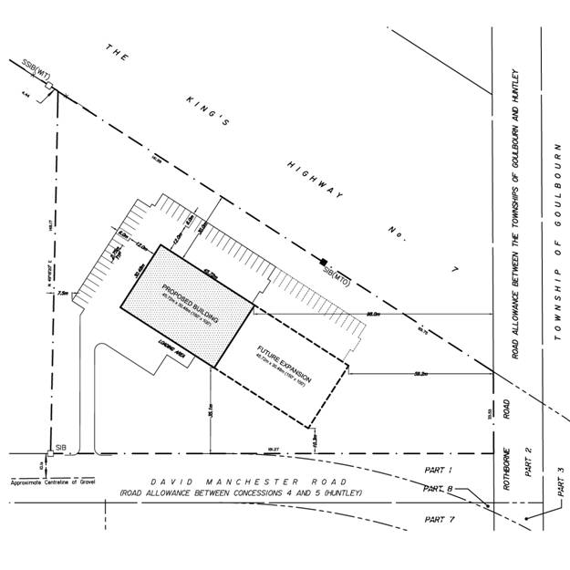
The intent is to construct a building with an
initial phase of between 1,393 and 1,858 square metres with the potential to
expand to a development between 2,787 to 3,716 square metres in the longer
term. The majority of the space is
warehouse with a small component for office and a retail showroom. The development concept is that the building
will have the appearance of fronting onto Highway 7 with access to the site
from the rear on David Manchester Road.
The property is currently zoned Rural Countryside
(RU). The intent of the RU Zone is to
accommodate land uses characteristic of Ottawa’s countryside in areas
designated General Rural Area, Rural Natural Features and Greenbelt Rural in
the Official Plan. The RU Zone
recognizes and permits a range of rural-based land uses while ensuring
compatibility with adjacent land uses and in respect of the rural context. The requested zoning is a site specific
zoning amendment to permit the proposed warehouse and retail/office uses.
DISCUSSION
Provincial Policy Statement
The Planning
Act requires that planning matters “be consistent with” the Provincial
Policy Statement (PPS).
Section 1.1.1 of the PPS promotes efficient
development and land use patterns which sustain the financial well-being of the
Province and municipalities over the long term; avoiding development and land
use patterns which may cause environmental or public health and safety
concerns; avoiding land use patterns that would prevent the efficient expansion
of settlement areas in areas which are adjacent or close to settlement areas;
and promoting cost-effective development standards to minimize land consumption
and servicing costs. The introduction of a
commercial industrial use in this location constitutes inefficient scattered
development.
Section 1.1.3.1 of the PPS recommends that
settlement areas shall be the focus of growth for new development to take
place. There is an existing supply of vacant
industrial land in the urban area to support the proposed warehouse use.
Section 1.1.4.1 states that in rural areas in
municipalities, development that is compatible with the rural landscape and can
be sustained by rural service levels should be promoted. The Official Plan sets out the type of new
uses that may be considered in the General Rural Area as part of a Zoning By-law
amendment application. The proposed use
is not compatible with the surrounding rural landscape which is comprised of
scattered residential uses, vacant and forested land. The proposed use is not related to the
management or use of resources, resource based recreational activities, limited
residential development or other rural land uses. The PPS promotes other economic opportunities
in rural areas of municipalities but not at the expense of the long term
availability of land and resources.
Further, Section 2.1.3 states that development
shall not be permitted in significant habitat or endangered or threatened
species unless it has been demonstrated that there will be no negative impacts
on the natural features or on their ecological functions. The Environmental Impact Statement prepared
in support of the proposed rezoning does not adequately ensure protection of
environmental features and functions on the site and adjacent to the site.
Official Plan
The
Official Plan designates the subject property Rural Natural Feature (RNF). Rural Natural Features are natural areas
within the rural setting that contain woodlands, wetlands and wildlife habitat
that were identified by the Natural Environment Systems Strategy (NESS –
Regional Municipality of Ottawa Carleton, 1997) as being significant within
Ottawa. The site and the larger property
to the north are part of RNF 419 which contains wetlands (including the
Provincially Significant Goulbourn Wetland Complex which is approximately 340
metres to the north of the property), and headwaters for tributaries feeding
into Huntley Creek.
Any
development proposed within a Rural Natural Feature designation must be
assessed in terms of its impact on the area’s natural features and functions,
particularly impacts arising from the extent of disturbance and the location of
buildings. An Environmental Impact
Statement (EIS) is required for development proposed within 120 metres of a
Rural Natural Feature or on lands adjacent to these designated areas. No development or site alteration is
permitted unless the EIS indicates it will have no negative impact, defined as
degradation that threatens the health and integrity of the natural features or
ecological functions for which an area is identified due to single, multiple or
successive development or site alteration activities.
Section
3.7.2 of the Official Plan (General Rural Area) is applicable to the subject
lands. A Zoning By-law amendment is
required where other new non-residential uses that would not be better located
within a Village and which are in keeping with the rural character or those
uses that meet the needs of the traveling public, such as a restaurant, gas
station, motel, retail of up to 1,000 square metres gross leasable area or
similar use. The following matters must
be considered when considering an application to amend the Zoning By-law to
permit a new use:
a) The use would not be better
located in a Village or the urban area;
The proposed warehouse / retail use is a destination
commercial use which intends to consolidate the retail and distribution
components of the current operation in the urban area to the rural area. The proposed use is not supportive of the
agricultural sector and exceeds the type and extent of commercial development
that could be contemplated as acceptable in the Rural Area. The proposed use is not related to the rural
economy and does not by its nature need to locate in the rural area. The proposed commercial (retail/warehouse) use
would be better situated in the urban area.
b)
If the use is to be located on a local road, it must be demonstrated that
the volume and pattern of traffic flow anticipated from the development will
not interfere with the proper functioning of the local road network;
The Transportation Impact Brief submitted in support of the proposed
rezoning states that David Manchester Road (a collector road) has capacity to
accommodate new traffic. Staff
interprets the transportation issue to be more indirectly associated with introducing
an incompatible use into the rural area.
While the warehouse use may be the predominant use on the site, the
retail function and its associated traffic is incompatible in a rural setting.
Staff are of the opinion that the site is removed from the interchange
with rural land in between the site and the interchange. The Official Plan does not encourage
commercial industrial uses at any rural interchange. Furthermore, the appropriate distances from
these interchanges has not been evaluated so it would be premature to consider
the proposed use when it has not been looked at comprehensively for all rural
interchanges city-wide and for lands abutting 400 series highways.
c)
The privacy of adjacent landowners or the amelioration of potential
adverse impacts from lighting, noise, odor, dust, or traffic can be achieved by
separating the land uses, buffering or other measures as part of the
development;
Destination retail uses are not permitted in the Rural Area and would
negatively impact adjacent rural landowners on David Manchester Road. The proposed landscape screening along the
frontage of the property facing David Manchester Road will not be sufficient to
mitigate the visual impact given that size and display component of the
warehouse which is expected to be “larger than normal” as described by the
applicant.
d)
The potential for reducing possible impacts on neighbouring agricultural
uses or nearby rural residential or Village communities, where relevant;
Screening and landscaping were the only mitigative measures suggested to
reduce possible impacts of the proposed use on neighbouring rural residential
uses.
e) The
development is in keeping with the surrounding rural character and landscape;
There are no commercial or industrial uses in proximity
to the site. While the site is located
adjacent to Highway 7, the site is physically about one kilometre removed from
the interchange and surrounded by rural land on all sides other than the side
abutting the highway. This would be
considered scattered development.
f)
All those requirements of Section 2 and 4 related to
transportation, servicing, design and compatibility and environmental protection;
This is discussed in sub-section (h) below, as well as in the review of
the Environmental Impact Statement later in the report.
g)
Noxious uses will only be considered where suitable screening and
buffering can be provided and generally these uses will not be considered in
locations within groundwater recharge areas or immediately adjacent to
residential areas, Scenic-Entry Routes or waterfront areas;
The Highway 7 corridor is identified as a Scenic-Entry Route in the
Official Plan. The goal of these routes
along principal roads is to orient travelers and provide direction to the
City’s attractions while the overall pattern of development must create a
favourable first impression of Ottawa.
Guidelines for Scenic-Entry Routes are being developed in order to
promote attention to such matters as building orientation, outside storage,
access and egress, landscaping, fencing, lighting and signage to create an
aesthetically pleasing streetscape. The
protection of views to natural and cultural heritage features, mature trees,
and roadside vegetation along and beyond the right-of-way is also
promoted. In the absence of any specific
guidelines, staff note one of the key characteristics of the site and the
proposed use is visibility from Highway 7.
That being said and given the rural setting at this interchange, the
proposed use and concept plan do not support the goals of protecting natural
heritage features, mature trees and roadside vegetation. In addition, the requirement for the use to
have outdoor display of merchandise is not compatible with these goals.
h)
The impact that the development will have on the protection of tree cover
and local wildlife movement, as a result of proposed site clearing and grading,
fencing, security lighting and other similar site plan matters.
While the Environmental Impact Statement (EIS) states that the site can be
developed without imposing negative impacts as defined in Section 4.7.8 of the
Official Plan, staff has reviewed the EIS and note a number of items requiring
additional information or clarification (see summary in the section on the
EIS). Staff acknowledge there are issues
which detract from the environmental significance of this property, including
a) existing disturbance (open area); b) no direct linkage to the larger
forested area that comprises RNF 419 due to power lines to the north, Highway 7
to the east, an old road allowance to the south and David Manchester Road to
the west; and c) the edge effect from the highway and David Manchester
Road.
In the comments received from
circulation, the Ottawa Forests and Greenspace Advisory Committee consider the
proposed rezoning to be inconsistent with the City’s requirement that there be
no adverse impacts on the Rural Natural Feature (RNF 419). The Committee’s position is that the proposed
development will effectively cut an important ecological linkage and isolate
the southern portion of the RNF 419 lands.
They further state that the removal of 70 per cent or more of forest
cover (on the site), will negatively impact the important function of
recharging the regional aquifer.
Staff are of the opinion that the larger planning issues relating to
locating a use that would be better situated in the urban area would have a
large environmental impact on RNF 419.
By accepting this as an appropriate use for the rural area and in a
Rural Natural Feature, we will see a further decline in the health of the
feature as more traffic is directed to the area as well as increased
development pressure once the new land use is introduced into the RNF.
Environmental Impact Statement
Official Plan Amendment (OPA) 76 requires that
any proposed development within 120 metres of a natural heritage feature system
not designated in the plan within the rural area must be supported by an
Environmental Impact Statement (EIS). An
EIS (McIntosh Perry Consulting Engineers Ltd., dated August 2010) was submitted
in support of the application and reviewed by staff. The EIS was found to be missing information
in a number of areas. Firstly, OPA 76
indicates that the subject property is situated adjacent to an area containing
Significant Woodlands. The submitted EIS
did not address Significant Woodlands.
Secondly, the report states that a species at
risk, the milksnake, has the potential of being present on the property. There are several other potential species at
risk common to Eastern Ontario that were not adequately addressed in the report
(i.e. butternut, bobolink, whip-poor-will, etc.). While milksnake was not observed during field
investigations, the Ministry of Natural Resources was not contacted for
additional comments in this regard.
Third, the report recommends that 30 per cent
forest cover be retained on the property but it is unclear if this can be
achieved. Fourth, the report recommends
that a 25-metre excavation buffer be applied from retained mature trees as well
as to replant a coniferous tree buffer along the front and rear property
lines. No dimensions of the planting and
retention areas were applied so it is unclear how these recommendations impact
the area of the building envelope and septic system.
Lastly, the EIS did not provide a cumulative
impact assessment as required by the Official Plan, Section 4.7.8.
Hydrogeological Assessment
In review of the
report, staff notes that insufficient details were provided to justify the
pumping test (i.e. there was no discussion as to the percentage of area used
for office, warehouse, and retail).
Staff is therefore not able to determine the anticipated water demand,
and hence cannot ascertain whether the subject parcel is large enough to
accommodate the proposed use. In
addition, information was missing regarding the impact of the proposed sewage
system on the groundwater, which in turn may have an impact on the area
requirement for the proposed development.
There was also insufficient data provided to establish water quantity
and quality, form both health and aesthetic perspectives.
Phase I Environmental Site Assessment
A Phase I Environmental Site Assessment was
conducted to obtain information about the subject property pertaining to items
of actual and/or potential site contamination. No significant potential items of
environmental concern relating to present or former occupants of surrounding
properties were identified during the review of neighbouring properties. However, the Phase I ESA identified the
presence of plastic oil containers and used oil filters having been left
on-site and electromagnetic radiation from high-tension electrical power lines
running through the subject site. The
report did not recommend whether a Phase II ESA was required.
Transportation Impact Brief
The
Transportation Impact Brief submitted in support of the proposed rezoning
states that David Manchester Road (a collector road) has capacity to
accommodate new traffic. There is a
two-way stop at the intersection of Hazeldean Road and David Manchester Road
that is expected to operate at an acceptable level of service once the proposed
development is completed.
Conclusion
Staff
do not support the proposed Zoning By-law amendment for the following reasons:
The
subject property is part of a much larger site containing significant
ecological features and functions. The
subject lands are designated Rural Natural Feature in the Official Plan. While the Environmental Impact Statement
(EIS) states that the site can be developed without imposing negative impacts
as defined in Section 4.7.8 of the Official Plan, staff has reviewed the EIS
and note a number of items requiring additional information or
clarification. Bringing the proposed use
into the rural area would have a large environmental impact on RNF 419. While the site itself presents a number of
issues which detract from its environmental significance, accepting the
proposed use will result in further decline in the health and integrity of the
features and functions of the area as more traffic is introduced and
development pressure increases once the new land use is introduced into the
RNF.
The
intended warehouse/retail use is not an appropriate use for the subject
property. Destination oriented
commercial uses are better located in an urban context where such sites can be
conveniently accessed and compliment other commercial uses. The proposed use is not supportive of the
agricultural sector and exceeds the type and extent of commercial development
that could be contemplated as acceptable in the Rural Area. The proposed use is not related to the rural
economy and therefore does not need to locate in the rural area. The introduction of a commercial industrial
use in this location constitutes scattered development and this may lead to
similar requests through the rural area.
Staff
are of the opinion that the site is well removed from the interchange with
rural land in between the site and the interchange. Commercial industrial development is not
encouraged at any rural interchange in the city and an analysis of possible
uses for rural interchanges and lands abutting 400 series highways has not been
completed.
RURAL
IMPLICATIONS
The introduction of a warehouse/retail use on the property is inconsistent with the rural character and would have a large environmental impact on Rural Natural Feature 419 over the long term.
CONSULTATION
Notice of this application was carried out in accordance with the City’s Public Notification and Consultation Policy.
Comments by the Ward Councillor(s)
The Councillor is aware of the staff
recommendation.
LEGAL
IMPLICATIONS
Should Council endorse the refusal and the
matter be appealed to the Ontario Municipal Board, it is expected that a
hearing of three to five days would result. It is anticipated that the hearing
could be conducted within staff resources.
There are no risk management implications
associated with this report.
FINANCIAL IMPLICATIONS
As outlined in the Legal Implications
section above, Ontario Municipal Board hearing could be conducted within staff
resources. Therefore, there are no direct financial implications associated
with this report.
Technology
Implications
N/A
City
Strategic Plan
Staff do not view the proposal
as being consistent with the proper management of growth and the creation of
sustainable communities.
SUPPORTING
DOCUMENTATION
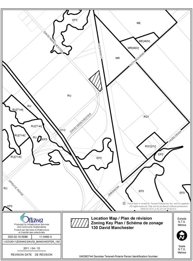
Document 1 Location Map
Document 2 Proposed Concept Plan
DISPOSITION
City Clerk and Legal Services Branch, Legislative
Services to notify the owner, applicant, OttawaScene.com, 174 Colonnade Road,
Unit #33, Ottawa, ON K2E 7J5, of City
Council’s decision.
LOCATION MAP DOCUMENT
1
PROPOSED CONCEPT PLAN
DOCUMENT 2