|
5. ZONING – 3905 INNES ROAD ZONAGE –
3905, CHEMIN INNES |
Committee recommendationS as
amended
(This matter is
Subject to Bill 51)
That Council approve an amendment to the
Zoning By-law 2008-250 to change the zoning of 3905 Innes Road from Residential
First Density, Subzone W (R1W) to Local Commercial, Subzone 6, Exception [xxx],
holding (LC6[xxx] h), as shown in Document 1 and detailed in Document 2, as
amended by the following:
1.
All uses
are to provide direct access to Innes Road
2.
An opaque
screen a height of 3.0 m is to be provided along the east property line
3.
An opaque
screen a minimum height of 2.5 metre measured from the average grade of the
property and Tooney Drive adjacent to the subject site is to be provided along
the north property line; and
that there be no further notice pursuant
to Section 34 (17) of the Planning Act.
RecommandationS MODIFIÉES DU Comité
(Cette question est assujettie au Règlement 51)
Que le Conseil approuve une modification au Règlement de zonage 2008-450
afin de changer la désignation de zonage du 3905, chemin Innes de Zone
résidentielle de densité 1, sous-zone W (R1W) à Zone de commerces locaux,
sous-zone 6, dotée d’une exception [xxx] et du symbole d’aménagement
différé (LC6[xxx]-h), comme il est
indiqué dans le Document 1 et expliqué en détail dans le Document 2, modifié
en ces termes :
1.
Toutes les utilisations doivent
permettre un accès direct au chemin Innes;
2.
Un écran opaque de trois mètres
doit être installé le long de la limite est de la propriété;
3.
Un écran opaque d’une hauteur
minimale de 2,5 mètres mesurée à partir du niveau du sol moyen de la
propriété et de la promenade Tooney adjacente doit être installé le long de la
limite nord de la propriété;
Qu’aucun autre avis ne soit donné, conformément au paragraphe 34(17) de
la Loi sur l’aménagement du territoire.
Documentation
1.
Deputy
City Manager's report, Infrastructure
Services and Community Sustainability, dated 28 July 2011 (ACS2011-ICS-PGM-0157).
2. Extract of
Draft Minutes 18, Planning Committee meeting of 15 August 2011
Report to/Rapport au :
Comité
de l'urbanisme
and Council / et au Conseil
28 July
2011 / le 28 juillet 2011
Submitted by/Soumis par : Nancy
Schepers, Deputy City Manager/Directrice municipale adjointe, Infrastructure
Services and Community Sustainability/Services d’infrastructure et Viabilité
des collectivités
Contact
Person/Personne-ressource : Derrick Moodie, Acting Manager/Gestionnaire
intérimaire, Development Review-Suburban Services/Examen des projets
d'aménagement-Services suburbains, Planning and Growth Management/Urbanisme et
Gestion de la croissance
(613)
580-2424, 15134 Derrick.Moodie@ottawa.ca
|
SUBJECT: |
|
|
|
|
|
OBJET : |
REPORT RECOMMENDATION
That the Planning Committee
recommend Council approve an amendment to the Zoning By-law 2008-250 to change
the zoning of 3905 Innes Road from Residential First Density, Subzone W (R1W)
to Local Commercial, Subzone 6, Exception [xxx], holding (LC6[xxx]‑h), as
shown in Document 1 and detailed in Document 2.
RECOMMANDATION
DU RAPPORT
Que le Comité de
l’urbanisme recommande au Conseil d’approuver une modification au Règlement de
zonage 2008-450 afin de changer la désignation de zonage du 3905, chemin Innes
de Zone résidentielle de densité 1, sous-zone W (R1W) à Zone de commerces
locaux, sous-zone 6, dotée d’une exception [xxx] et du symbole d’aménagement
différé (LC6[xxx]-h), comme il est
indiqué dans le Document 1 et expliqué en détail dans le Document 2.
BACKGROUND
Purpose of Zoning Amendment
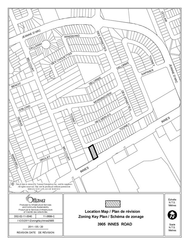
The subject site is located on the north side of Innes Road, east of Belcourt Boulevard and currently contains a single storey detached dwelling with a number of accessory buildings.
To the west and south is commercial development and to the north and east is low density residential development. The subject site has an area of 1380 square metres with 22 metres of frontage along Innes Road and 22.8 metres of frontage along Tooney Drive. The site is currently serviced by municipal water and private on-site septic system.
The purpose of the zoning amendment is to permit limited commercial uses on the subject site, subject to site specific requirements.
Existing Zoning
The site is currently zoned Residential First Density, Subzone W (R1W) and does not permit commercial uses.
Proposed Zoning
The proposed zoning is to zone to site to a site specific Local Commercial (LC) zone to allow for a limited number of commercial and residential uses.
DISCUSSION
Official Plan
The Official Plan designation of the site is General Urban Area. This designation permits a full range and choice of housing types, in combination with conveniently located employment, retail, service, cultural, leisure, entertainment and institutional uses. This is to facilitate the development of complete and sustainable communities.
Details of Proposed Zoning
Limited commercial uses are appropriate on the subject site. The site is within a transition area between the residential uses located and fronting on Tooney Drive and the commercial development on both sides of Innes Road. The proposed retail use will utilize the shell of the existing building, renovate the interior and alter the exterior to reflect the new use. Limited to the existing mass, it will therefore be compatible with a residential development.
It is anticipated the current road network is able to accommodate the traffic expected to be generated by the proposal. Innes Road is classified as an arterial road in the Official Plan and access to the site will be restricted to a right-in/right-out on Innes Road. It is proposed that all future commercial uses will be limited to access from Innes Road only. Access to Tooney Drive will not be permitted without the lifting of the existing 0.30 metre reserve, should it be proposed for a residential use.
Parking is to be in accordance with the relevant provisions of the Zoning By-law and no changes are proposed to the existing rates. Bus stops and sidewalks are provided and a pedestrian connection to the residential area is located approximately 83 metres to the east of the subject site.
The site is currently serviced by municipal water and a private septic system. The existing septic system is located on the north portion of the site, between the existing building and Tooney Drive. At this time, it is not anticipated the proposed use will generate more demand on the septic system than the existing single detached dwelling. The use of the holding symbol is proposed to delay the conversion to a retail use until such time as approval is provided for the septic system by the Ottawa Septic System Office. All other permitted uses will require a connection to the municipal system. When the existing subdivision to the north was designed, it anticipated and took into account in the calculations of the capacity of the sewer system that the subject site might be connected to the system. The 0.30m reserve was placed along the Tooney Drive frontage to ensure paybacks to the developer of the subdivision at the time the subject site is developed with services and access to Tooney Drive. The location of the septic system will preclude the area from being used for parking as long as the septic system exists. It is recommended that the setback of the parking lot be increased from 1.5m to 3.0m, in order to provide a greater separation between any future parking lot and the residential use.
The current proposal is not subject to the Site Plan Control By-law, as the existing building will be used and no site works will trigger the requirement for site plan control approval. In order to mitigate the impact of the use on the adjacent residential developments, a number of buffering provisions are proposed. Any future development may trigger the need for site plan control and will provide the opportunity for the City to review the site and landscaping plans, elevations, servicing and access.
Signage will be subject to the sign by-law for commercial development adjacent to residential development.
In conclusion, the Department is recommending approval of the proposed amendment in that the zoning will appropriately limit the non-residential uses on the site to appropriate uses, subject to specific requirements. If the recommendation is approved as proposed, the single detached dwelling would become a legal non-conforming use.
RURAL IMPLICATIONS
N/A
CONSULTATION
Notice of this application was carried out in accordance with the City's Public Notification and Consultation Policy. Comments were received by a number of adjacent residents and are summarized in Document 3.
COMMENTS BY THE WARD COUNCILLOR(S)
The Ward Councillor is aware of this application and provides the following comment:
‘I would support the rezoning with the proviso that the owner provides the necessary fencing and landscaping to shield the neighbours and that we work with the abutting commercial property to bring about improved conformity and privacy.’
LEGAL IMPLICATIONS
There are no legal
implications associated with this report.
RISK MANAGEMENT IMPLICATIONS
There are no risk implications.
FINANCIAL IMPLICATIONS
There are no direct financial implications associated
with this report.
ENVIRONMENTAL
IMPLICATIONS
There are no environmental implications of the proposal. The septic system will require a permit from the Ottawa Septic System Office at the time a building permit is issued.
TECHNOLOGY IMPLICATIONS
CITY STRATEGIC PLAN
In accordance with the City’s Strategic Plan, the proposal respects the existing urban fabric.
APPLICATION PROCESS TIMELINE STATUS
This application was processed by the "On Time Decision Date" established for the processing of Zoning By-law amendment applications.
SUPPORTING DOCUMENTATION
Document 1 Location Map
Document 2 Details of Recommended Zoning
Document 3 Consultation Details
DISPOSITION
City Clerk and Solicitor Department, Legislative Services to notify the owner, applicant, OttawaScene Canada Signs, 1565 Chatelain Avenue, Ottawa, ON K1Z 8B5, Ghislain Lamarche, Program Manager, Assessment, Financial Services Branch (Mail Code: 26-76) of City Council’s decision.
Planning and Growth Management to prepare the implementing by-law, forward to Legal Services and undertake the statutory notification.
Legal Services to forward the implementing by-law to City Council.
LOCATION MAP DOCUMENT
1
DETAILS OF RECOMMENDED ZONING DOCUMENT 2
Proposed Changes to the Comprehensive Zoning By-law
a) The subject lands shown in Document 1 be rezoned from R1W to LC6[xxx]-h.
b) A new exception, LC6[xxx]-h be added to Section 239-Urban Exceptions to include the following:
i) Uses prohibited:
drive through facility
gas bar
ii) Provisions:
- A retail use limited to a maximum of 90 square metres gross floor area is permitted on private sewerage when the holding symbol is removed from the property
- The holding symbol can only be removed when the Ottawa Septic System Office approves the septic system for the retail use
- All permitted uses, except a retail use limited to a maximum of 90 square metres gross floor area, must be connected to full municipal services
- All non-residential uses are to provide direct access to Innes Road
- Outdoor display is prohibited
- Despite Table 110, minimum required width of a landscaped buffer for a parking lot abutting a residential use or zone: 3.0m
- An opaque screen a minimum height of 1.8 metres is to be provided along the east property line
- An opaque screen a minimum height of 2.5 metres measured from the average grade of Tooney Drive adjacent to the subject site is to be provided along the north property line.
CONSULTATION DETAILS DOCUMENT
3
NOTIFICATION AND CONSULTATION PROCESS
Notification and public consultation was undertaken in accordance with the Public Notification and Public Consultation Policy approved by City Council for Zoning By-law amendments.
One Community Information and Comment Session was held on July 5, 2011. Approximately five residents were in attendance. As a result of the meeting and signage, three responses were received opposing the proposal. A number of comments received also indicated opposition to the proposal, however, provided suggestions if the commercial proposal was to go forward.
PUBLIC COMMENTS
1. Concern with respect to the gradual erosion of the residential character of the portion of Innes.
2. If commercial uses are to be permitted, uses should be restricted, adequate parking is to be provided, lighting and signage should not to impact the residential uses and fencing and landscaping is to be provided in order to buffer the property from the existing residential uses.
SUMMARY OF PUBLIC INPUT
1. This property abuts a commercial development to the west and south and residential uses to the east and north. It has the potential for access to be either provided from Innes Road or Tooney Drive. It is a property within a transition area between uses and with appropriate building and site design, either commercial and residential uses may be accommodated.
2. The recommendation proposes a prohibition of specific uses. The parking rate is not being amended; therefore any use must comply with the requirements of the zoning by-law. Proposed lighting will be reviewed at the site plan control stage and signage is subject to the Signage By-law. Specific buffering requirements are proposed along the north and east property lines.