|
1. ZONING – PART OF 4265 LIMEBANK ROAD ZONAGE –
PARTIE DU 4265, CHEMIN LIMEBANK |
Committee recommendation
(This matter is
Subject to Bill 51)
That Council approve an amendment to the City of Ottawa Zoning By-law
2008-250 to change the zoning of part of 4265 Limebank Road from DR –
Development Reserve to R3Z – Residential Third Density Subzone Z, R3Z[xxxx] –
Residential Third Density Subzone Z exception
xxxx, R3Z[yyyy]-h – Residential
Third Density Subzone Z exception yyyy with
a holding symbol and O1 – Parks and Open Space Zone as shown in Document
1 and as detailed in Document 2.
Recommandation DU Comité
(Cette question est assujettie au Règlement
51)
Que
le Conseil approuve une modification au Règlement de zonage 2008-250 de la
Ville d’Ottawa afin de changer la désignation de zonage d’une partie du 4265,
chemin Limebank de DR – Zone d’aménagement futur à R3Z – Zone résidentielle de
densité 3, sous-zone Z, R3Z [xxxx] - Zone résidentielle de densité 3, sous-zone
Z, exception xxxx, R3Z [yyyy]-h - Zone résidentielle de densité 3, sous-zone Z,
exception yyyy accompagnée du symbole d’utilisation différée et O1 – Zone de
parc et d’espace vert, comme il est indiqué dans le Document 1 et expliqué en
détail dans le Document 2.
DOCUMENTATION
1.
Deputy City
Manager’s report, Infrastructure Services and Community Sustainability, dated
13 May 2011.
Report to/Rapport au :
Comité de l’urbanisme
and Council / et au Conseil
13 May 2011 / le 13 mai 2011
Submitted by/Soumis par : Nancy Schepers, Deputy City Manager/Directrice
municipale adjointe, Infrastructure Services
and Community Sustainability/Services d’infrastructure et Viabilité des
collectivités
Contact Person/Personne-ressource : Derrick Moodie,
Acting Manager/Gestionnaire intérimaire, Development Review-Suburban
Services/Examen des projets d’aménagement-Services suburbains, Planning and
Growth Management/Urbanisme et Gestion de la croissance
(613) 580-2424, 15134
Derrick.Moodie@ottawa.ca
|
SUBJECT: |
ZONING
– Part Of 4265 Limebank Road (FILE NO. D02-02-09-0024) |
|
|
|
|
OBJET : |
REPORT
RECOMMENDATION
That the recommend
Council approve an amendment to the City of Ottawa Zoning By-law 2008-250 to
change the zoning of part of 4265 Limebank Road from DR – Development Reserve
to R3Z – Residential Third Density Subzone Z, R3Z[xxxx] – Residential Third
Density Subzone Z exception xxxx, R3Z[yyyy]-h – Residential Third Density
Subzone Z exception yyyy with a holding
symbol and O1 – Parks and Open Space Zone as shown in Document 1 and as detailed
in Document 2.
RECOMMANDATION DU
RAPPORT
Que le Comité de recommande au Conseil au Conseil d’approuver
une modification au Règlement de zonage 2008-250 de la Ville d’Ottawa afin de
changer la désignation de zonage d’une partie du 4265, chemin Limebank de DR –
Zone d’aménagement futur à R3Z – Zone résidentielle de densité 3, sous-zone Z,
R3Z [xxxx] - Zone résidentielle de densité 3, sous-zone Z, exception xxxx, R3Z
[yyyy]-h - Zone résidentielle de densité 3, sous-zone Z, exception yyyy
accompagnée du symbole d’utilisation différée et O1 – Zone de parc et d’espace
vert, comme il est indiqué dans le Document 1 et expliqué en détail dans le
Document 2.
BACKGROUND
The subject site is located to the south of Spratt Road and to the east of Limebank Road in the Riverside South Community.
The parcel is irregular in shape and is bisected by Mosquito Creek valley lands and a Hydro One corridor. The site is vacant and has an area of approximately 34.6 hectares with frontage on Spratt Road, Limebank Road and Earl Armstrong Road.
Surrounding the subject property, to the north and east are future
residential lands, to the south is future Riverside South Community Core Area and to the west are Mosquito Creek valley
lands.
Purpose
of Zoning Amendment
The proposed Zoning By-law
Amendment is required to allow development of a fully serviced residential
subdivision in the Riverside South Urban Area – Neighbourhood 1.
Existing
Zoning
The existing zoning of the property is DR, Development Reserve which recognizes lands that are intended for future urban development.
Proposed
Zoning
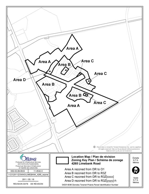
The proposed zoning is R3Z, Residential Third Density Subzone Z, R3Z[xxxx], Residential Third Density Subzone Z exception [xxxx], R3Z[yyyy]-h, Residential Third Density Subzone Z exception [yyyy] with holding symbol and O1, Parks and Open Space Zone. This zoning will permit an urban residential development of single detached dwellings, on-street townhouses, park and open space blocks to proceed.
The use of the exception [xxxx] is to recognize that for specific detached dwelling lots, the maximum separation between the garage and building or porch does not apply. Specifically, the following provision of Endnote Number 8 does not apply:
No portion of a private garage or carport shall be located more than 2.5 metres closer to a street lot line than the closer of:
(i) a building front wall or side wall, or
(ii) a covered porch or veranda that is at least 2.5 metres wide.
The use of the exception [yyyy]-h sets out a condition under which the holding symbol on the 10 lots located on the north side of Cooks Mill Crescent can be lifted. The holding symbol prevents the 10 lots from being developed until on-site filling has occurred and the limit of development line is re-drawn beyond the boundaries of the residential lots in accordance with a Rideau Valley Conservation Authority (RVCA) permit.
The Mosquito Creek valley lands, the community park, multi-use pathway, Hydro One corridor and storm water management lands are zoned O1, Parks and Open Space Zone.
DISCUSSION
Provincial Policy Statement
The Provincial Policy Statement (PPS) provides direction on matters of Provincial Interest related to land-use planning and development by promoting efficient land use patterns that support development of viable liveable communities. Contained within the policy statement are explicit policy objectives that focus on growth in settlement areas, providing an appropriate range of housing with densities that efficiently use land resources (infrastructure and public service facilities), promoting public transit and other alternative transportation modes and creating healthy and active communities.
The proposed development is consistent with the objective and policies of the PPS and provides new residential development that makes efficient use of available and projected infrastructure services.
Official
Plan
The Official Plan
designates the properties as General Urban with a Developing Community
overlay. This designation permits the
development of a full range and choice of housing types to meet the needs of all,
in combination with conveniently located related uses such as leisure, retail,
service and institutional uses. The Developing Community overlay requires the
completion of a community design plan prior to any development being approved. The Riverside South Community Design Plan
(CDP) was approved June 2005.
The Riverside South
CDP was updated due to the completion of the master servicing studies which did
cause minor revisions to be made to the CDP.
Council approved the update of the Riverside South CDP on January 13,
2010. The CDP designates this phase of the subdivision lands for Low, Medium
and High Density Residential, Valley Land, Hydro, Storm Water Management and
Community Park.
The subdivision
application for 4209 Limebank Road (D07-16-09-0009) received Draft Approval on
March 24, 2010.
Details of Proposed
Zoning
The applicant is requesting that the zoning for the first phase of development in the Riverside South Phase 5 Draft Approval area known as part of 4265 Limebank Road be changed to allow the subdivision to proceed in advance of the filling and re-grading of the lots on the north side of Cooks Mill Crescent.
The original application requested that the zoning be changed to R3Z[xxxx], R3Z[yyyy]-h and O1.
Further to review of the requested zoning and in consultation with the City, the applicant has requested two revisions to the original zoning application.
The first revision is to recognize that only 11 site specific detached lots are to be subject to the exception to not have the maximum separation distance between the garage and the front of building of 2.5 metres, instead of the entire subdivision. The second revision is to remove the stipulation that the exception only applies to lots having frontages less than 15 metres as it was realized that four of the 11 lots had frontage over 15 metres.
Therefore the requested zoning is R3Z, R3Z[xxxx], R3Z[yyyy]-h and O1.
The R3Z zone will permit the development of the single detached dwellings and row dwellings.
The R3Z[xxxx] zone will permit site specific detached dwelling lots to be developed with the maximum separation distance of 2.5 metre between the garage and the building face not applying.
The R3Z[yyyy]-h zone will permit the lots on the north side of Cooks Mill Crescent to be developed once the requirements of the RVCA have been met and the holding symbol has been removed.
The Z subzone establishes design elements that allow compact build form. The purpose is to permit different development standards primarily for areas designated as Development Communities to promote efficient land use.
One of the design elements is set out in the Z subzone, Table 160B, Endnote Number 8 as follows:
No portion of a private garage or carport shall be located more than 2.5 metres closer to a street lot line that the closer of:
(i) a building front wall or side wall; or
(ii) a covered porch or veranda that is at least 2.5 metres wide.
This design element establishes site criteria to limit the maximum separation between the garage and a wall of a house, be it a front wall, a side wall, a covered porch or veranda to 2.5 metres. The purposes of these site criteria are to ensure porches or verandas are functional not decorative, to minimize the visual impact of garage doors along streets and to emphasizing views to and from the street from main windows, front doors and/or porches. All these criteria when combined with other urban design guidelines provide for a varied and interesting streetscape.
For this phase of development, it was discovered that there are two detached dwelling models that have a greater separation distance between the garage and the front of the house. There are a total of 11 lots out of the 95 detached dwelling lots where these two model types can locate.
Therefore in consideration that the subdivision will be developed using a combination of different model types for single family homes and on street townhouses with varying Lot and Block sizes, the overall impact of this zoning exception will be minimal to the character of the built form in this neighbourhood in Riverside South. In conclusion, the intent of the Urban Design Guideline for Greenfield Neighbourhoods is being maintained by providing a varied and interesting streetscape.
The use of the holding symbol, described within Exception [yyyy]-h, for all 10 lots along the north side of Cooks Mill Crescent will ensure that the lots cannot be developed until the land is filled, the limit of development line is re-drawn beyond the boundaries of the residential lots and approval has been received from the Rideau Valley Conservation Authority (RVCA). Although the RVCA has stipulated that only six of the lots need the ‘h’ symbol, the applicant has request that the ‘h’ symbol apply to all 10 lots to allow for flexibility in re-grading across the entire residential lot area north of Cooks Mill Crescent.
The Parks and Open Space zone, O1, will permit a community park and pathway block together with recognizing the Mosquito Creek valley lands, a Hydro One corridor and a Storm Water Management corridor. Further to the RVCA clarification point that the O1 zone line applied to the north park boundary, the proposed zone line will define the north limit of O1 lands for this area of the subdivision. The actual limits of the individual subdivision blocks which may include a park block, multi-use pathway block and Storm Water Management block will be determined through the subdivision process and all these land uses are permitted within the O1 zone.
Zoning Recommendation
Staff are satisfied that the proposed changes in the zoning of part of 4265 Limebank Road to R3Z, R3Z[xxxx], R3Z[yyyy]-h and O1 is consistent with the policies of the Provincial Policy Statement, the Official Plan and the Riverside South CDP and recommend approval.
RURAL IMPLICATIONS
N/A
CONSULTATION
Notice of this application was carried out in accordance with the City’s Public Notification and Consultation Policy. The City did not receive any negative comments or opposition to this application.
COMMENTS BY THE WARD COUNCILLOR
The Ward Councillor is aware of this application and staff’s recommendation.
LEGAL IMPLICATIONS
There are no legal
implications associated with this report.
RISK MANAGEMENT IMPLICATIONS
There are no risk implications.
FINANCIAL
IMPLICATIONS
There are no direct financial implications associated
with this report.
ENVIRONMENTAL IMPLICATIONS
The Rideau Valley Conservation Authority (RVCA) has no objection to the proposed Zoning By-law Amendment in support of the Riverside South Phase 5-1 lands (also referred to as the CR2 lands) however there are two points of clarification:
1. Lots 5 to 10 are the only ones that need to have the holding zone applied to prevent the lots from being developed until the limit of development lines are re-drawn once on-site filling in accordance with an RVCA permit is completed and accepted. Lots 1 to 4 do not require the ‘h’.
2. The O1 zone applied to the park boundary should reflect a revised draft plan that alters the park boundaries to accommodate the additional setback from the stormwater/watercourse corridor.
TECHNOLOGY IMPLICATIONS
There are no technology implications.
CITY STRATEGIC PLAN
Manage growth and
create sustainable communities by:
· becoming leading edge in community and urban
design
· ensuring that new growth is integrated
seamlessly with established communities
· ensuring that community facilities are built
in tandem with new development.
Ensure that the City
infrastructure required for new growth is built or improve as need to serve
growth.
APPLICATION PROCESS TIMELINE STATUS
This application was
processed by the “On Time Decision Date” established for the processing of
Zoning By-law amendment applications.
SUPPORTING DOCUMENTATION
Document 1 Location Map
Document 2 Details of
Recommended Zoning
DISPOSITION
City Clerk and Solicitor Department, Legislative Services to notify the
owner, applicant, OttawaScene Canada Signs, 1565 Chatelain Avenue, Ottawa, Ontario,
K1Z 8B5, Ghislain
Lamarche, Program Manager, Assessment, Financial Services Branch (Mail
Code: 26-76) of City Council’s decision.
Planning and
Growth Management to prepare the
implementing by-law, forward to Legal Services and undertake the statutory
notification.
Legal Services to forward the
implementing by-law to City Council.
LOCATION MAP DOCUMENT
1
DETAILS OF RECOMMENDED ZONING DOCUMENT 2
Proposed
Changes to the Comprehensive Zoning By-law
- The
subject lands shown on Document 1 will be rezoned from DR- Development Reserve to R3Z, R3Z[xxxx] - Residential Third
Density Subzone Z[xxxx], R3Z[yyyy]-h – Residential Fifth Density Subzone Z
with holding provision [yyyy]-h and O1 - Parks and Open Space Zone.
2. Add exceptions to Section
239 with text similar in effect to the following:
Exception [xxxx]
a) in Column II the text: "R3Z[xxxx], and
b) in Column V the text: The following provision of Endnote Number 8 does not
apply for a detached dwelling:
No portion of a private garage or carport shall be located more than 2.5 m closer to a street lot line that the closer of:
(i) a building front wall or side wall, or
(ii) a covered porch or veranda that is at least 2.5 m wide.
Exception [yyyy]
a) in Column II the text: “R3Z[yyyy]-h”,
and
b) in Column IV the text: “-all uses until
the holding symbol is removed”, and
c) in Column V the text:
The holding symbol may not be
removed until:
(i) on site filling in accordance with the Rideau Valley Conservation Authority (RVCA) Permit has been completed and accepted; and,
(ii) the limit of development line has been re-drawn beyond the boundaries of the residential lots to the satisfaction of the RVCA and the General Manager, Planning and Growth Management;