|
3.
ZONING - 3033 COLONIAL road ZONAGE - 3033, chemin colonial |
COMMITTEE RECOMMENDATION
(This
application is subject to the provisions of Bill 51.)
That Council approve
an amendment to Zoning By-law 2008-250 to change the zoning of two parts of
3033 Colonial Road, including Area A from Agricultural Subzone 3 (AG3) to
Agricultural Subzone 7 (AG7) and Area B from Development Reserve 1 (DR1) to
Village First Density, Subzone E, as shown on Document 1.
RECOMMANDATION DU COMITÉ
(Cette application est
assujettie aux dispositions du Règlement 51.)
Que le Conseil
approuve une modification au Règlement de zonage 2008-250 afin de changer la
désignation de zonage de deux parties du 3033, chemin Colonial, y compris le
secteur A de Zone agricole, sous-zone 3 (AG3) à Zone agricole, sous-zone 7
(AG7) et le secteur B de Zone d’aménagement futur 1 (DR1) à Zone résidentielle
de village de densité 1, sous-zone E, comme il est indiqué sur le Document 1.
Documentation
1. Deputy City Manager’s Report,
Infrastructure Services and Community Sustainability, dated 13 May 2011
(ACS2011-ICS-PGM-0124).
2. Extract of Draft Minutes, 2 June 2011.
Report to/Rapport au :
Agriculture and Rural Affairs Committee
Comité d'agriculture et des affaires
rurales
and Council / et au Conseil
13 May 2011 / le 13 mai 2011
Submitted by/Soumis par :
Nancy Schepers, Deputy City Manager/Directrice
municipale adjointe, Infrastructure Services
and Community Sustainability/Services d’infrastructure et Viabilité des collectivités
Contact
Person/Personne-ressource : Derrick Moodie, Manager/Gestionnaire, Development
Review-Rural Services/Examen des projets d'aménagement-Services ruraux,
Planning and Growth Management/Urbanisme et Gestion de la croissance
(613)
580-2424, 15134 Derrick.Moodie@ottawa.ca
|
SUBJECT: |
|
|
|
|
|
OBJET : |
REPORT RECOMMENDATION
That the Agriculture and Rural
Affairs Committee recommend Council approve an amendment to Zoning By-law 2008-250
to change the zoning of two parts of 3033 Colonial Road, including Area A from Agricultural
Subzone 3 (AG3) to Agricultural Subzone 7 (AG7) and Area B from Development
Reserve 1 (DR1) to Village First Density, Subzone E, as shown on Document 1.
RECOMMANDATION
DU RAPPORT
Que le Comité de l’agriculture
et des affaires rurales recommande au Conseil d’approuver une modification au
Règlement de zonage 2008-250 afin de changer la désignation de zonage de deux
parties du 3033, chemin Colonial, y compris le secteur A de Zone agricole,
sous-zone 3 (AG3) à Zone agricole, sous-zone 7 (AG7) et le secteur B de Zone
d’aménagement futur 1 (DR1) à Zone résidentielle de village de densité 1,
sous-zone E, comme il est indiqué sur le Document 1.
BACKGROUND
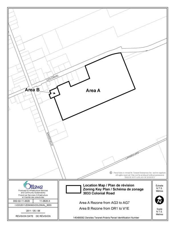
The subject land, 3033 Colonial Road, is located on the south side of Colonial Road, east of the intersection of Sarsfield Road. The site is primarily agricultural surrounded by agricultural uses to the north, south, and west. The Village of Sarsfield is located to the immediate east of the property, and a small portion of the property is within the Village boundary. The subject land has a broken frontage of 270.37 metres along Colonial Road and an area of approximately 15.45 hectares.
This parcel was the subject of a recent consent application comprising two parts. The first part was a request to create a new lot for a surplus farm residence. The second part was a lot line adjustment for the portion of the property located within the village. As a condition of the lot line adjustment, the shed on this portion of the property was to be demolished. The vacant retained land will contain 14.35 hectares and will be known municipally as 3065 Colonial Road.
Purpose of Zoning Amendment
Area A: The proposal is to rezone a part of the subject land to meet a condition of consent to sever a surplus farm dwelling imposed by the Committee of Adjustment (Application No. D08-01-10/B-00413). The land to be severed will have a frontage of 76.2 metres on Colonial Road and contain a lot area of 0.74 hectares. It will contain a single-family dwelling, garage and a shed.
Area B: The proposal is to rezone the portion of the subject land to meet a condition of a lot line adjustment (Application No. D08-01-10/B-00412) and ensure these lands are consistent with the lands to which they are conveyed. The land to be severed will have an area of 0.36 hectares and will be merged with an existing lot to the east known as 2971 Colonial Road.
Existing Zoning
Area A is currently zoned Agricultural Subzone 3 (AG3). This zoning recognizes and permits agricultural uses on a minimum lot area of 10 hectares in areas designated Agricultural Resource Area in the Official Plan and restricts the range of permitted uses to agricultural, forestry and related uses in order to preserve prime agricultural lands from loss to other uses.
Area B is currently zoned Development Reserve 1 (DR1). This zoning recognizes lands intended for future urban development in areas designated as General Rural Area and Developing Communities in the Official Plan; and future village development in areas designated as Village in the Official Plan.
Proposed Zoning
Area A: The requested zoning amendment proposes to rezone the retained parcel (farmland) from Agricultural Subzone 3 (AG3) to Agricultural Subzone 7 (AG7). This zoning permits agricultural uses, but prohibits residential uses. This particular subzone represents agricultural lands with a minimum area of 10 hectares and a minimum frontage of 60 metres.
Area B: The requested zoning amendment proposes to rezone the lands subject to the boundary adjustment from Development Reserve 1 (DR1) to Village Residential First Density, subzone E (V1E). This zoning permits detached dwellings in areas designated Village in the Official Plan, a limited range of compatible uses and regulates development in a manner that adopts existing land use patterns so that the low density, low profile form of a neighbourhood is maintained and enhanced.
DISCUSSION
Official Plan
Area A is designated Agricultural Resource Area. This designation protects prime agricultural areas from loss of lands to other uses. The policies ensure that a severance for the creation of a new lot on which is located a dwelling made surplus through farm consolidation does not permit the construction of a new dwelling on the lot rendered vacant through the severance. The policies require that the vacant agricultural parcel so created be rezoned to prohibit any residential uses. The housing restriction is intended to limit a pattern of lot creation in Agricultural Resource Areas that would see a new residence being constructed on the vacant farm property, the house being declared surplus and severed for a lot, and the pattern so continued.
Area B is designated Village in the Official Plan. The intent of the Village designation is to permit a variety of uses to allow the rural community to meet their daily needs and to ensure the community remains distinctly rural in character and scale. The portion of land which is the subject of the lot line adjustment is designated Village-Residential in the Village land use plan. The property to which this parcel is being conveyed is planned Village-Mixed Use and permits single detached dwellings, apartments and commercial uses.
Section 5.3, Other Implementation Policies, Policy 3 (Boundary Adjustments) of the Official Plan states: The City will permit lot adjustments in any land use designation for legal or technical reasons...which do not result in the creation of a new or render an existing lot as non-confirming.
Zoning By-law
Area A is zoned Agricultural Subzone 3 (AG3). The AG3 zone permits a detached dwelling, agricultural use and several other uses. In order to ensure that the intent of the Official Plan policies is implemented in the Zoning By-law, it is recommended that the zoning of a portion of the subject land (retained farmland) be changed from Agriculture Subzone 3 (AG3) to Agricultural Subzone 7 (AG7), as shown on Document 1. The AG7 zone will prohibit residential uses on a lot having a minimum area of 10 hectares and a minimum lot width of 60 metres. This rezoning is considered appropriate since it will protect agricultural land from loss to other uses and the lot will continue to respect the minimum lot area and width requirements.
Area B is zoned Development Reserve 1 (DR1). The DR1 zone recognizes lands intended for future urban development in areas designated as General Rural Area and Developing Communities in the Official Plan; and future village development in areas designated as Village in the Official Plan. The rezoning is in keeping with the policies of the Official Plan. The proposed boundary line adjustment does not convey productive farmland to the residential property, does not create a new lot, and is being undertaken for technical reasons in order to provide sufficient land to the abutting property owner to address future septic issues.
RURAL IMPLICATIONS
Area A will be limited to agricultural uses. By restricting residential uses, major agricultural areas will be protected from fragmentation and competing uses. The effect of this rezoning will be to enhance the rural heritage and fortify the rural landscape. Rezoning Area B will allow the severed piece of land to come under a single zoning designation consistent with the abutting land to the east.
CONSULTATION
Notice of this application was carried out in accordance with the City's Public Notification and Consultation Policy. The City did not receive any negative comments or opposition to this application.
COMMENTS BY THE WARD COUNCILLOR(S)
The Ward Councillor is aware of this application and the staff recommendation.
LEGAL IMPLICATIONS
There are no legal implications associated with this report.
RISK MANAGEMENT IMPLICATIONS
N/A
FINANCIAL IMPLICATIONS
There are no direct financial implications.
CITY STRATEGIC PLAN
N/A
TECHNOLOGY IMPLICATIONS
APPLICATION PROCESS TIMELINE STATUS
This application was processed by the "On Time Decision Date" established for the processing of Zoning By-law amendment applications.
SUPPORTING DOCUMENTATION
Document 1 Location Map
DISPOSITION
City Clerk and Solicitor Department, Legislative Services to notify the owner, applicant, OttawaScene.com, 174 Colonnade Road, Unit #33, Ottawa, ON K2E 7J5, Ghislain Lamarche, Program Manager, Assessment, Financial Services Branch (Mail Code: 26-76) of City Council’s decision.
Planning and Growth Management to prepare the implementing by-law, forward to Legal Services and undertake the statutory notification.
Legal Services to forward the implementing by-law to City Council.
LOCATION MAP DOCUMENT
1