|
1. ZONING
- PART OF 195 MEANDERING BROOK DRIVE ZONAGE - PARTIE
DU 195, PROMENADE MEANDERING BROOK |
Committee recommendationS
(This matter is
Subject to Bill 51)
That Council approve:
1.
An amendment to the Zoning By-law 2008-250 to
change the zoning of part of 195 Meandering Brook Drive from O1 – Open
Space to R5A[1235] H(22) –
Residential Fifth Density Subzone A Exception [1235] zone with a maximum height
limit of 22 metres, as shown in
Document 1.
2.
That the
implementing by-law not proceed to Council until such time as the application
for Site Plan Control has been approved.
RecommandationS du comité
(Cette question est assujettie au Règlement 51)
Que
le Conseil :
1.
approuve une modification au Règlement de zonage 2008-250 en vue de faire passer le
zonage d’une partie du 195, promenade Meandering Brook de O1 – Espace ouvert à R5A[1235] H(22) – Zone résidentielle de densité 5, sous-zone A, exception
[1235], assortie d’une hauteur maximale de 22 mètres, tel qu’illustré dans le Document 1.
2.
que le règlement d’application ne
soit pas soumis au Conseil
avant que la demande de réglementation du plan
d’implantation n’ait été approuvée.
Documentation
1.
Deputy
City Manager's report, Infrastructure
Services and Community Sustainability, dated 31 March 2011 (ACS2011-ICS-PGM-0060)
2.
Extract
of Draft Planning Committee Minutes of 12 April 2011.
Report to/Rapport au:
and Council / et au Conseil
31 March 2011 / le 31 mars 2011
Submitted by/Soumis par :
Nancy Schepers, Deputy City Manager/Directrice
municipale adjointe, Infrastructure Services
and Community Sustainability/Services d’infrastructure et Viabilité des
collectivités
Contact
Person/Personne-ressource : Derrick Moodie, Manager/Gestionnaire,
Development Review/Examen des projets d'aménagement,
Planning and Growth Management/Urbanisme et Gestion de la
croissance
(613)
580-2424, 15134 Derrick.Moodie@ottawa.ca
|
SUBJECT: |
ZONING
- Part of 195 meandering brook drive (FILE NO. d02-02-10-0044) |
|
|
|
|
OBJET : |
REPORT RECOMMENDATIONS
That the Planning Committee
recommend Council approve:
1.
An amendment to the Zoning By-law 2008-250 to
change the zoning of part of 195 Meandering Brook Drive from O1 – Open
Space to R5A[1235] H(22) – Residential
Fifth Density Subzone A Exception [1235] zone with a maximum height limit of 22
metres, as shown in Document 1.
2.
That the implementing
by-law not proceed to Council until such time as the application for Site Plan Control
has been approved.
RECOMMANDATIONS
DU RAPPORT
Que le Comité de
l’urbanisme recommande au Conseil :
1.
d’approuver une modification au Règlement de zonage 2008-250 en vue de faire passer le
zonage d’une partie du 195, promenade Meandering Brook de O1 – Espace ouvert à R5A[1235] H(22) – Zone résidentielle de densité 5, sous-zone A, exception
[1235], assortie d’une hauteur maximale de 22 mètres, tel qu’illustré dans le Document 1.
2.
Que le règlement d’application ne
soit pas soumis au
Conseil avant que la demande de réglementation du
plan d’implantation n’ait été approuvée.
BACKGROUND
The subject
parcel is located at the northeast intersection of Lester Road and Meandering
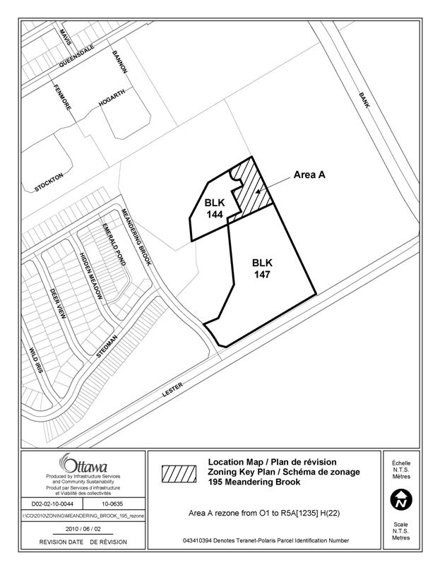
Brook Drive, between Albion Road South and Bank Street. The parcel is irregular in shape and currently vacant. The subject parcel, Block 144 is
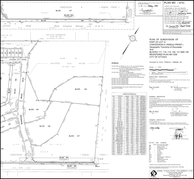
located within a registered plan of subdivision and is approximately 3.14 acres
in size as shown on Document 3, however only 1.45 acres are proposed to be
rezoned with the remaining lands retaining the O1 – Open Space designation as
shown on Document 1. On the east
side of Meandering Brook Drive there is an existing park and stormwater
management pond and park that was constructed through the first phase of
development within the Deerfield’s Estate subdivision. On the west side of Meandering Brook Drive
there are single-detached and attached residential dwelling units. The south side of Lester Road is undeveloped
Greenbelt lands owned by the National Capital Commission (NCC).
The lands were
previously owned by the NCC and were sold to the Canada Lands Company (CLC) in
2001. In 2003, upon the completion of multiple
stakeholder meetings and a design charrette, applications for an Official Plan Amendment, Zoning By-law Amendment and draft
plan of subdivision were brought forward to implement the recommended development
concept. Through the registration of the
plan of subdivision, specific conditions were placed on title with respect to
the future development of Block 144. As
per the subdivision agreement, Block 144 is to be developed and maintained as a
private stormwater
management facility servicing only Block 147.
As well, the subdivision agreement requires that Blocks 144 and 147 be
merged in title upon their development.
Further, upon the development of the stormwater pond, an access road is to be constructed and
an easement is to be granted in favour of the City.
Purpose of Zoning Amendment
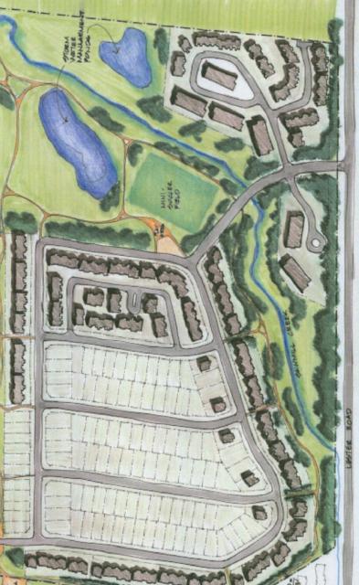
The application proposes to amend a 1.45-acre portion of Block 144 to allow for additional residential development consistent with the range of permitted development on the abutting lands to the south (Block 147). The change in zoning would allow for the development of a planned unit development (PUD) over Blocks 144 and 147 as shown on Document 5. The PUD would consist of a range of dwelling types including 120 stacked townhomes, 60 loft dwellings and 78 urban flats totalling 258 units. Based on feedback from the public consultation process, the total amount of units was reduced from the original 269 units proposed. As well, the units proposed for the portion of Block 144 to be rezoned from O1 to R5A[1235] H(22) has been reduced from 44 to 35 residential units.
The
subject parcel Block 144 is currently zoned O1 - Open Space. The O1 zone permits uses such as community
gardens and parks. Residential
development in the form of a PUD is currently not permitted within this zone,
and as a result, a change in zoning is required for portions of the block to
allow for the residential uses.
The application proposes to rezone a portion of Block 144 to R5A[1235] H(22) which is consistent with zoning found on the abutting lands to the south. The R5A subzone permits a range of high-density residential uses such as planned unit development, low-rise and high-rise apartments, and stacked dwellings. Lower density uses such as detached, linked detached and semi-detached dwellings are not permitted. Exception 1235 speaks to site-specific performance standards for the subzone which the application is not proposing to amend. As well, there is a maximum building height limit of 22 metres which would also apply to the subject parcel. The remaining lands in Block 144 would continue to be zoned O1 - Open Space and are not proposed to be developed with residential units.
DISCUSSION
Strategic Directions
To meet the challenge of managing growth within the city, growth in the Urban
Area will be directed to areas where it can be accommodated in compact and
mixed-use development, and served with quality transit, walking and cycling
facilities. Growth will be directed to
the urban area where services already exist or where they can be provided
efficiently. Within the General Urban
Area, opportunities for intensification exist and will be supported. Where a zoning by-law amendment is required,
the appropriateness of the scale of development will be evaluated along with
the design and its compatibility.
Official Plan
The subject lands are designated as General Urban Area within the Official Plan. The General Urban Area designation permits the development of a full range and choice of housing and broad scale of uses, in combination with conveniently located employment, retail, service and institutional uses. The City supports infill development and other intensification with the General Urban Area in a manner that complements and enhances the desirable characteristics and ensures the long-term vitality of the existing communities.
When considering a proposal for residential intensification through infill or redevelopment, the City considers how the new development relates to the character of existing development, the policies of Section 2.5.1 and 4.11, and their contribution to the maintenance and achievement of a balance of housing types, and assesses ground-oriented multiple housing forms as one means of intensifying within established low-rise residential communities.
With respect to the proposed rezoning relating to the character of existing development, the general layout and scale of development will create an urban form that is consistent with the development concept plan prepared through the CLC consultation as shown on Document 4. As shown schematically on the plan and later implemented through the plan of subdivision process, a second storm water management pond is identified and required to service the lands east of Sawmill Creek (Block 147).
It was recognized during the preparation of the concept plan and the advancement of planning applications, that a detailed engineering analysis was never undertaken to determine the exact size, shape and design (wet-pond versus dry-pond) of the second storm water management pond. This is an exercise that would typically be completed through the Site Plan Control process. Based on the studies completed in support of the Site Plan Control application, a smaller pond can accommodate the stormwater for this site. Whereas the CLC concept plan showed a wet pond, the proposed pond will be constructed as a dry pond. The concept plan also shows a higher density form of development for the abutting lands to the south which is appropriately zoned. The application proposes to continue the development pattern established over a portion of Block 144 as the necessary studies have determined that the area originally reserved for a second pond is in excess of what is now technically required. As there is a requirement for an access road to be constructed for the pond, the introduction of additional residential units on a portion of Block 144 which complements the development on Block 147 is considered a compatible form of residential development. The density of the development proposed for Block 144 has been reduced from 44 to 35 residential units and the massing has been reduced from five buildings to three buildings in an effort to provide additional landscaping and open space closest to Sawmill Creek.
With respect to the proposed form of residential development, the introduction of ground-stacked townhouse dwelling and low-rise apartments creates a balance and variety in the choice of housing within an established low-rise community. They are considered appropriate and compatible forms of development.
Compatibility Considerations
Section 2.5.1 of the Official Plan, sets out broad design objectives and principles to be applied when evaluating an application for intensification and infill development. The design objectives are qualitative statements intended to influence the built environment. Design Principles further describe how the City hopes to achieve the Design Objectives, which may or may not be achievable in all cases. The proposed development is consistent with, and implements the various aspects of the design objectives and principles discussed below. The objectives of greatest significance to the application speak to defining quality public and private spaces, creating places that are safe, accessible, easy to get to, and move through, ensuring that the new development respects the character of existing areas.
Defining quality public and private spaces is achieved by the introduction of a new built form along the portion of the site which abuts Meandering Brook Drive. As well, the orientation and spacing of the buildings have created private amenity spaces through the site which are highly accessible and visible for residents. Further, the entrances to the site have been designed to allow for a vista which has a high degree of landscaping in an effort to screen parking areas from the street.
The development of a safe and efficient vehicular movement network and
pedestrian system is in keeping with the second key design objective. The internal road system allows for multiple
route options through the site and is controlled with internal signage to
create safe crossings for pedestrians.
The Concept Plan also shows numerous internal sidewalks and pathways that
allow residents to safely move through the site when walking to individual
residences, amenity spaces or public transit.
Public transit along Lester Road is also served through a direct link at
the eastern edge of the property and from Meandering Brook Drive which is
separated from vehicular traffic. The
orientation of the buildings internally creates spaces that are visible and
safe for residents during all times of the day.
Creating a new development that respects
the character of existing areas, such as Sawmill Creek and the existing park,
is achieved through the revised design of Block 144. Through the reduction in number of units,
building footprint and the number of buildings, more of the block will remain
undeveloped which is in keeping with the openness of the park and watercourse,
which are in a naturalized state. The
various reductions in Block 144 will allow for additional landscaping and
buffering to further compliment existing vegetation. The placement and design of the stormwater
management pond also creates a further buffer, and due to its planned function,
remains open and undeveloped where additional landscaping elements can be
introduced.
In addition to Section 2.5.1, the Official Plan requires that applications for development be assessed relative to the criteria set out in Section 4.11 which deal with compatibility. While Section 2.5.1 focuses more on context and design matters to ensure compatibility, Section 4.11 sets out more traditional planning criteria dealing with matters such as traffic, parking, and built form relationships. The Official Plan clarifies that the criteria may not apply and/or may be evaluated and weighted on the basis of site circumstances. Many of the issues raised relate to those matters addressed by Section 4.11. The following discussion highlights how the subject application responds to these criteria so as to ensure that the proposed development will not result in any adverse impacts and that it will co-exist with surrounding developments and uses.
Traffic / Vehicular Access
Traffic generated from the site is not expected to create any adverse impacts as a result of the reduction in units, the second full-movement access being added to Lester Road and the installation of new traffic signals at the intersection of Meandering Brook Drive and Lester Road.
Parking Requirements
The proposed development concept as shown on Document 5 is proposing 54 visitor parking spaces whereas the by-law requires 52. The Concept Plan is also proposing 322 parking spaces for residents whereas the By-law requires 310. As the Concept Plan meets and exceeds the required parking for the site, staff do not foresee any adverse impacts.
Building Massing and Height/Pattern of the Surrounding Community
The proposed height of the
new buildings will comply with the maximum height currently permitted within
the R5A[1235] H(22) zone. The actual building heights are proposed to
be in the range of 14.5 metres which is well below the current performance
standard.
As the two parcels are
being planned as one larger PUD, the rhythm and massing of the development is
consistent throughout the site. While
the mass of the various residential products is inherently larger and greater
in height than a typical single-detached dwelling, this impact is reduced by
the separation of the site from the first phase of development. The subject site is well separated from the
first phase of development by Sawmill Creek and the existing stormwater management
pond and park, and as a result there is no anticipated impact on the private
amenity spaces on the homes which front onto Meandering Brook Drive and Stedman
Street.
The orientation of the PUD with an internal figure-eight road design will allow for adequate pedestrian and vehicular circulation. As well, with the orientation of front facades onto Meandering Brook there will be an improved built form when first entering the subdivision. There are also no proposed driveways leading to individual garages along this frontage; as all parking for the development is orientated to the interior in an effort to be screened by proposed buildings.
In summary, the proposed development conforms to the intent of the Official Plan with respect to the land use policies for the General Urban Area and as such, staff recommends approval of the proposed rezoning.
An application for Site Plan Control (file D07-12-10-0124) was submitted concurrently with the application for change in zoning.
RURAL IMPLICATIONS
N/A
CONSULTATION
Notice of this application was carried out in accordance with the City's Public Notification and Consultation Policy. Details of the Public Notification can be found in Document 4.
COMMENTS BY THE WARD COUNCILLOR
Initial Comments – July 13, 2010
·
I am
opposed to the rezoning of the Open Space to R5A. Residents are also not
supportive of the request to re-zone Open Space to R5A.
·
There
are considerable community concerns surrounding traffic impacts on this site
plan application.
·
I will
not support a single exit from Phase II onto Meandering Brook Dr (safety issues
plus many school kids waiting for school bus).
·
I would
ask that the applicant seek another entrance off Lester, which would involve
discussions with the NCC. A secondary exit will allow for pedestrian movements
to access transit onto Lester Road.
·
A
traffic signal at Lester Road and Meandering Brook Drive prior to construction
of any new development is a must.
·
Please
review Albion Road at Lester Road intersection and recommend changes to improve
traffic circulation.
·
A
westbound right-turn lane must be provided on Lester Road at Meandering Brook
Drive.
·
Parking
needs to be sufficiently contained on this site.
·
Given
the proposed density, limited parking and target audience for these homes,
there will be an immediate requirement for increased transit service on Lester
Road.
·
As a
condition of approval, please include wider shoulders on Lester Road, cycling
lanes, sidewalks and better bus stop pads with shelters.
·
As a
condition of approval, please include a water / splash pad feature in an
existing park.
·
Please
ensure that the Pathway network from Findlay Creek to north of Queensdale is
connected for residents to access transit, amenities, and recreational uses.
·
Please
provide a plan for, snow removal, snow storage and how any salt accumulation
may impact the Sawmill Creek.
·
Please
provide a plan as to how garbage pick up will be conducted and whether garbage,
recyclables and organics will be placed each week fronting onto Meandering
Brook Drive.
·
Please
provide a pedestrian link between the proposed new development and the sports
field/ park.
·
Please
ensure that construction vehicles are provided with a dedicated access route
from Lester Road.
·
The
applicant was present at my Public Open House on June 29th, 2010 and is aware
of the high degree of concern expressed by the community to date. I would ask
that the applicant revise its current re-zoning and site plan to better reflect
the site's size and ability to accommodate housing.
·
In
conclusion, I do not believe that this current proposal works at the 195
Meandering Brook site, and would ask that the applicant reconsider this
proposal.
Follow-up Comments –
April 1, 2011
After two public meetings and many meetings with the proponent and City
staff, I believe that the community concerns have been satisfactorily
addressed. I believe that this revised site plan is a compromise that is
in the best interest of all and I support the applicant’s development
applications
LEGAL/RISK MANAGEMENT IMPLICATIONS
There are no legal/risk management implications associated with this report.
CITY STRATEGIC PLAN
The application is consistent with the Planning and Growth Management objective of managing growth and creating sustainable communities by ensuring that new growth is integrated seamlessly with establish communities.
The proposed rezoning will allow for a form of development that is consistent with the land use concept envisioned through the Canada Lands Company design exercise.
TECHNICAL IMPLICATIONS
FINANCIAL IMPLICATIONS
If this matter is appealed to the Ontario Municipal Board it is anticipated that a three to five day hearing would be required. Should the recommendation be adopted, it is expected that the hearing could be conducted within staff resources.
If the application for a rezoning is refused, reasons must be provided. A planner would need to be retained by the City and, depending on the reasons for refusal, it may also be necessary to retain a transportation witness. The estimated costs to the City would be approximately $25,000 for the Planner and $40,000 for a transportation witness.
APPLICATION PROCESS TIMELINE STATUS
The application was not processed by the "On Time Decision Date" established for the processing of Zoning By-law amendments due to the additional time requried to address issues related to the site plan and change in zoning applications.
SUPPORTING DOCUMENTATION
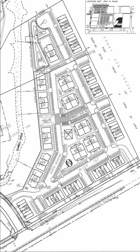
Document 1 Location Map
Document 2 Registered Plan of Subdivision 4M-1290
Document 3 Design Charrette Development Concept Plan
Document 4 Consultation Details
Document 5 Concept Plan
DISPOSITION
City Clerk and Solicitor Department, Legislative Services to notify the owner, applicant, OttawaScene.com, 174 Colonnade Road, Unit #33, Ottawa, ON K2E 7J5, Ghislain Lamarche, Program Manager, Assessment, Financial Services Branch (Mail Code: 26-76) of City Council’s decision.
Planning and Growth Management to prepare the implementing by-law, forward to Legal Services and undertake the statutory notification.
Legal
Services to forward the implementing by-law to City Council.
LOCATION MAP DOCUMENT
1
REGISTERED PLAN OF SUBDIVISON – 4M-1290 DOCUMENT 2
DESIGN CHARETTEE DEVELOPMENT CONCEPT PLAN DOCUMENT 3
CONSULTATION DETAILS DOCUMENT
4
NOTIFICATION AND CONSULTATION PROCESS
Notification and public consultation was undertaken in accordance with the Public Notification and Public Consultation Policy approved by City Council for Zoning By-law amendments. Two public meetings were also held in the community which was organized by the Ward Councillor and attended by staff, the applicant and their respective consultants. The meetings were held on June 29, 2010 and March 2, 2011. Below is a summary of the comments received during the public consultation process and from the two public meetings, along with a staff response.
PUBLIC COMMENTS
1. Concerns were raised with respect to the operation of the intersection of Meandering Brook Drive and Lester Road as a result of the development (i.e. waiting time, stacking and safe turning movements).
Response:
The applicant has prepared a traffic impact study in support of their application which was reviewed and approved by staff. The study concluded that a traffic signal was not warranted at this location, at this time in accordance with City of Ottawa standards. Notwithstanding that a signal is not warranted, the applicant has agreed to assume the costs for the installation of new traffic signals at this intersection along with all necessary roadway modifications.
The original concept plan proposed only one access to serve the development, which is located as far from the subject intersection as possible. As a result of comments from staff and the public, the concept plan has been revised to now provide a second full-movement access onto Lester Road at the eastern limit of the property. The introduction of this second access along with the reduction of units and new signalization are not expected to create any undue adverse impacts.
2. Concerns were raised with respect to the potential for spill-over parking into the adjacent neighbourhood streets.
Response:
The required on-site parking for residential 258 units is 310 parking spaces for residents and 52 visitor parking spaces. The revised concept plan shows 322 parking spaces for residents and 54 spaces for visitors which are both above the required rates as per By‑law 2008-250.
3. Concerns were raised with respect to snow storage on site.
Response:
The applicant has identified areas on the concept plan for snow storage. The applicant also intends to arrange through the Site Plan Control and Plan of Condominium processes the removal of excess snow from the site.
4. Concerns were raised with respect to the amount of density proposed for Block 144.
Response:
The original concept plan proposed 44 residential units to be built within five new buildings on Block 144. The revised plan now proposes 35 units to be built within three buildings. The revised concept has reduced the density proposed for the block, the built footprint on site, and allowed for additional landscaping and snow storage.
5. Concerns were raised with respect to the existing speed limits on Lester Road.
Response:
The ability to adjust the posted speed of a particular street or road is not available through either the Zoning By-lay Amendment of Site Plan Control process. This particular issue was discussed at the most recent public meeting and the Councillors office will pursue this issue with appropriate staff.
6. Comments were brought forward with respect to what purchasers in first phase of the Deerfields development were advised would be built on the remaining lands within the subdivision. Purchasers were told that single-detached homes would be constructed on the subject lands.
Response:
Staff cannot comment on the information distributed by the various builders to purchasers at that time, however during the build-out of first phase of the Deerfields community the zoning was in place for Block 147 which did not permit single or semi-detached buildings. The intent of Block 147 through the design process and implementing zoning by-law is to accommodate and allow for higher density forms of development. The applicant has not requested a zoning by-law amendment to the current permitted uses for Block 147.
CONCEPT PLAN DOCUMENT 5