|
2. Multi-Use Pathway Connection – Coventry Road To Train Station: Environmental Assessment Study
Sentier polyvalent – du chemin coventry à la station d’O-Train : Étude d’évaluation environnementale
|
Committee recommendation
That Council approve the finalization of the Environmental Study Report for the multi-use pathway connection between Coventry Road and the Train Station and posting of the Notice of Study Completion.
Recommandation DU Comité
Que le Conseil approuve la finalisation du rapport d’étude environnementale pour le sentier polyvalent devant relier le chemin Coventry à la station Train et l’affichage de l’avis d’achèvement de l’étude.
Documentation
1. Deputy City Manager’s report, Infrastructure Services and Community Sustainability, dated 18 February 2011 (ACS2011-ICS-PGM-0070).
2. Extract of draft minutes dated 2 March 2011.
Report to / Rapport au :
Transportation Committee
Comité des transports
and Council et au Conseil
18 February 2011 / le 18 février 2011
Submitted by / Soumis par: Nancy Schepers, Deputy City Manager/Directrice municipale adjointe, Infrastructure Services and Community Sustainability/Services d’infrastructure et Viabilité des collectivités
Contact Person / Personne ressource : Vivi Chi, Manager/Gestionnaire, Transportation Planning/Planification des transports, Planning and Growth Management/Urbanisme et Gestion de la croissance
(613) 580-2424 x21877, vivi.chi@ottawa.ca
|
Ref N°: ACS2011-ICS-PGM-0070 |
|
SUBJECT: |
Multi-Use Pathway Connection – Coventry Road To Train Station: Environmental Assessment Study |
|
|
|
|
OBJET : |
Sentier polyvalent – du chemin coventry à la station d’O-Train : Étude d’évaluation environnementale |
REPORT RECOMMENDATION
That Transportation Committee recommend Council approve the finalization of the Environmental Study Report for the multi-use pathway connection between Coventry Road and the Train Station and posting of the Notice of Study Completion.
RECOMMANDATION DU RAPPORT
Que le Comité des transports recommande au Conseil d’approuver la finalisation du rapport d’étude environnementale pour le sentier polyvalent devant relier le chemin Coventry à la station Train et l’affichage de l’avis d’achèvement de l’étude.
EXECUTIVE SUMMARY
Assumptions and Analysis:
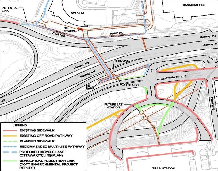
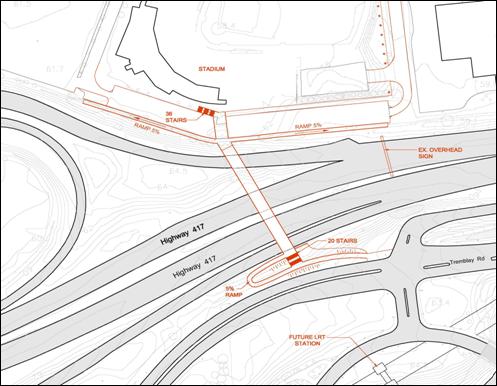
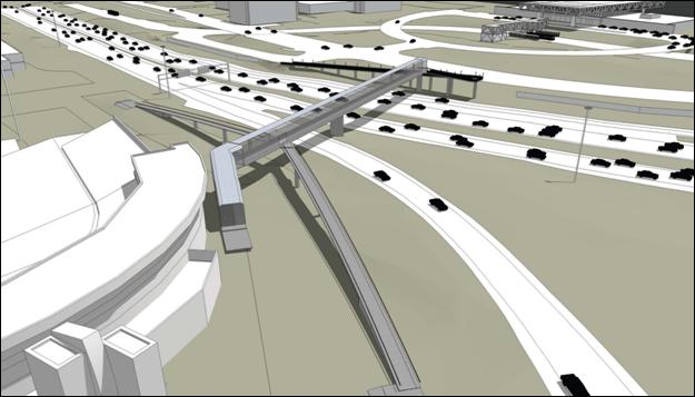
The Environmental Assessment Study recommends a new multi-use (pedestrian/cyclist) pathway between the Train Transitway Station and Coventry Road to include a new footbridge structure over the Queensway as shown in the Recommended Plan (Document 1).
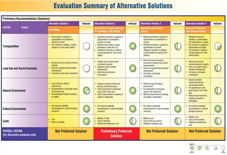
This study fulfils all Municipal Class Environmental Assessment requirements. Several alternative solutions were evaluated (Document 2) followed by an evaluation of alternative methods to implement the preferred solution (Document 3).
Legal/Risk Management Implications:
There are no legal/risk management impediments to the implementation of this Report's recommendations.
Financial Implications:
The preliminary cost estimate to construct the multi-use pathway and footbridge is approximately $8.8 million in 2011 dollars.
The 2011 draft capital budget includes funds to proceed with detailed design in 2011.
Public Consultation/Input:
An extensive consultation program was undertaken throughout the course of the study which included the public, municipal, provincial, and federal governments and external agencies.
The project included two public meetings that were advertised in the daily newspapers and quarterly newsletters that were emailed to all identified stakeholders. A Public Advisory Committee and an Agency Advisory Committee were established and met several times through the course of study. A project web site was also established (http://www.ottawa.ca/train-coventry).
Résumé
Hypothèses et analyse :
L’étude d’évaluation environnementale recommande l’aménagement d’un sentier polyvalent (piétonnier/cyclable) entre la station Train du Transitway et le chemin Coventry, un projet qui comprendrait la construction d’une passerelle pour piétons au-dessus du Queensway, tel qu’illustré dans le plan recommandé (Document 1).
Cette étude respecte toutes les exigences d’une évaluation environnementale municipale de portée générale. Plusieurs solutions de rechange ont été prises en compte (Document 2) et les diverses possibilités de mise en œuvre ont ensuite été évaluées en vue d’appliquer la solution privilégiée (Document 3).
Répercussions légales et gestion des risques :
Sur le plan juridique ou de la gestion des risques, rien n’empêche la mise en œuvre des recommandations contenues dans le présent rapport.
Répercussions financières :
Le coût estimé provisoire de la construction du sentier polyvalent et de la passerelle est d’environ 8,8 millions de dollars, en dollars de 2011.
Les prévisions du budget d’immobilisation de 2011 englobent les fonds nécessaires au lancement en 2011 de la conception détaillée du projet.
Consultation publique / Commentaires :
Un vaste programme de consultation, mené tout au long de l’étude, a sollicité la participation des membres du public, de représentants des administrations municipale, provinciale et fédérale ainsi que d’organismes externes.
Les deux réunions publiques prévues dans le cadre de ce projet ont été annoncées dans les quotidiens et dans les bulletins trimestriels transmis par courriel à toutes les parties intéressées s’étant manifestées. Un comité de consultation publique et un comité consultatif constitué de membres d’organismes ont été créés et se sont réunis à plusieurs reprises tout au long de l’étude. Un site Web du projet a également été créé (http://www.ottawa.ca/train-coventry).
BACKGROUND
In December 1995, the former City of Ottawa approved The Coventry Road Plan of Development, which included a multi-use pathway connection over the Queensway between Coventry Road and the Train Transitway Station. This link was deemed necessary to improve future access to rapid transit and to encourage transit-oriented development along Coventry Road.
Since then, this multi-use pathway connection has been incorporated into the City’s Official Plan (OP) and Transportation Master Plan (TMP). The OP, TMP and the City’s Strategic Plan encourage improved access to transit through a number of mechanisms, including integrating the pedestrian and cycling networks with transit facilities such as the Train Transitway Station. The City’s Strategic Plan also requires an emphasis on walking, transit and cycling oriented communities and employment centres.
The current TMP (2008) identifies a multi-use pathway connection across the Queensway adjacent to the Train Transitway Station to be in place by 2015.
The OP and TMP also provide the following policy directions:
§ The TMP describes the need for sustainable transportation through active transportation and the need to create links to transit nodes such as the Train Transitway station as well as the provision of multi-use pathways for walking, cycling, and other active modes, especially in, adjacent to, or across rapid transit corridors, and within and between neighbourhoods;
§ This pathway connection supports the modal targets and transit oriented development policies of the Official Plan that promote walking, cycling, and transit while reducing dependency on automobiles during peak hours;
§ The Official Plan policy to have major urban facilities (Ottawa Stadium) connected to rapid transit stations would be facilitated with this pathway;
§ This pathway connection provides an opportunity to increase safety and security for pedestrians and cyclists over existing facilities in the area;
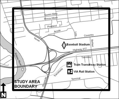
The Statement of Work (SoW) for this study was approved by Transportation Committee in September 2009. It defined the study area to include the lands primarily between the Rideau River, Queen Mary Street, Belfast Road and Terminal Road, as shown in Figure 1. This area includes a portion of the Overbrook Community, an established residential neighbourhood located north of the Queensway comprised primarily of residential uses but also has commercial, office, and industrial uses, particularly in the vicinity of Coventry Road.
The Train Transitway Station, currently part of the City’s Transitway network, is located adjacent to the VIA Rail station along Tremblay Road, east of Riverside Drive and west of Belfast Road. The station is to be converted to a light rail transit (LRT) station and is to remain in the same general location (with a slight shift to the northwest) as part of the Phase I LRT project.
Figure 1: Study Area
Pedestrians and cyclists who live, work or travel through Overbrook are confronted with the barrier of Highway 417 which prevents them from having convenient direct access to the rapid transit service provided at the Train Transitway Station on the south side of the highway. To get to the station requires not only an onerous amount of back-tracking but involves streets, particularly the Vanier Parkway / Riverside Drive and Belfast Road, that are not conducive to the active transportation modes of walking and cycling.
Transportation solutions are needed that will support the objectives set out in the Official Plan and Transportation Master Plan that improve access to the Train Transitway Station and promote transit use. Solutions that encourage walking and cycling from the Overbrook community represent opportunities to meet City planning objectives. The transportation solutions will improve access and reduce travel times to the Train Transitway Station and will better connect the Overbrook community, Ottawa Stadium, offices, retail stores, and hotel/convention center on the north side of the Queensway to the Train Transitway Station and the VIA Rail Station on the south side of the Queensway.
DISCUSSION
The Environmental Assessment Study recommends that a safe and secure multi-use (pedestrian/cyclist) pathway connection be provided between the Train Transitway Station and Coventry Road. This would include a new footbridge structure over the Queensway with east and west pathway connections to Coventry Road on the north side and the use of an existing underpass connection on the south side to connect to the Train Transitway Station (see Document 1 – Recommended Plan).
The Recommended Plan was arrived at in accordance with the process for ‘Schedule C’ projects outlined in the Municipal Engineers Association “Municipal Class Environmental Assessment” document (October 2000, as amended in 2007).
The following planning solutions to the undertaking were considered:
§ Alternative 1: Do Nothing – This alternative was included in the assessment to provide a benchmark against which the other alternatives could be compared. It includes improvements already planned by the City of Ottawa.
§ Alternative 2: Provide a Crossing of the Queensway to the Train Transitway Station – This alternative includes a grade separated crossing of Highway 417 to connect the Overbrook community to the Train Transitway Station.
§ Alternative 3: Improved Transit Service – This alternative involves providing transit bus service connecting the Overbrook community to the Train Transitway Station.
§ Alternative 4: Travel Demand Management – This alternative involves improved pedestrian and cycling infrastructure on existing routes.
The above planning solutions were evaluated based on transportation/engineering, socio-economic/heritage, natural environment and financial criteria. The evaluation was completed with input from the project team, agency and stakeholder input and public consultation which identified Alternative 2 as the preferred solution (Document 2).
The Class Environmental Assessment process requires the examination of alternative methods of implementing the preferred solution by considering design alternatives.
There are several potential constraints in the vicinity of the general bridge crossing location which were taken into consideration while developing alignment options. These constraints include presence/former presence of three underground storage tanks, the planned widening of Highway 417 by MTO, two watermains located immediately south of Highway 417 and north of Tremblay Road, and the presence of high-mast lighting and overhead signage on Highway 417.
Three primary crossing locations were identified (Figure 2) based on the most direct anticipated desire line for pedestrians and cyclists between the Ottawa Stadium and the Overbrook community to the north and the Train Transitway Station to the south, taking into consideration the constraints in the vicinity of the crossing. Figure 3 illustrates the preferred alignment as the most direct connections to the front of the Ottawa Stadium with an additional ramp connection to the east of the stadium.
Figure 2: Footbridge Alignment Options
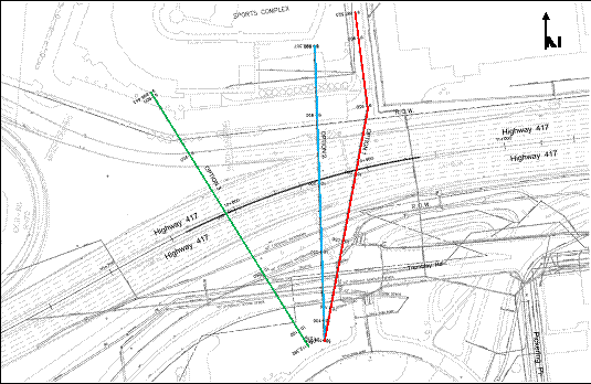
Figure 3: Recommended Footbridge Alignment
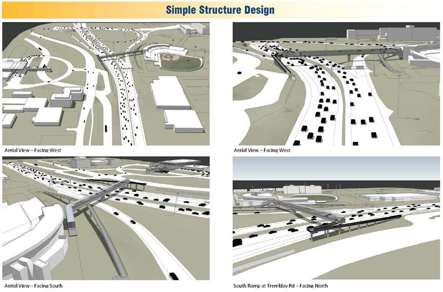
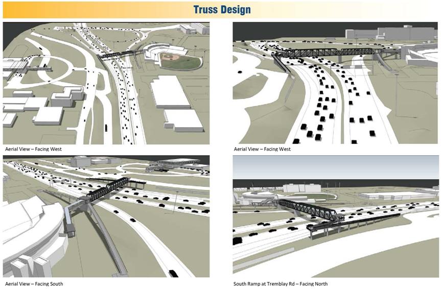
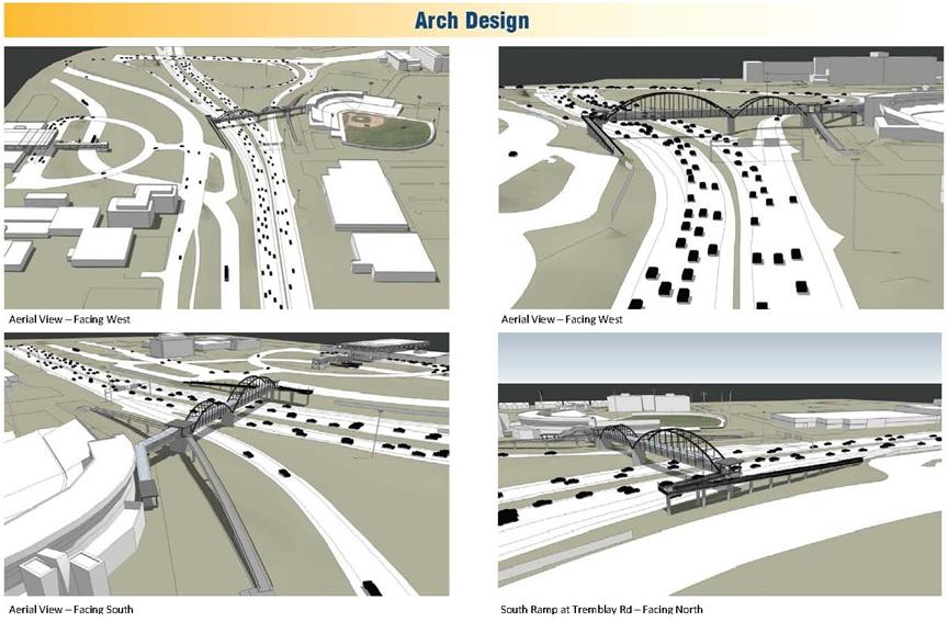
In order to visualize the potential aesthetic and architectural features of the new multi-use footbridge, several architectural concepts were proposed, including the following:
§ Concept 1: Simple Structure Bridge
§ Concept 2: Truss Bridge (using historical references to a train trestle / train station structure to highlight the proximity of the Ottawa Train Station);
§ Concept 3: Arched Structure (options include single span / multiple span bridge);
§ Concept 4: Single Mast Suspension Bridge; and
§ Concept 5: Double Mast Suspension Bridge.
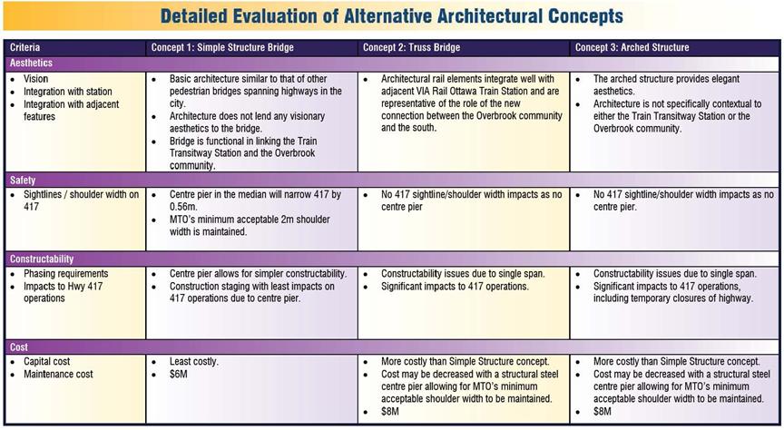
A coarse evaluation of the architectural concepts was undertaken to narrow down the architectural concepts to be further developed. The Simple Structure Bridge, Truss Bridge, and Arched Bridge were carried forward for more detailed analysis. An evaluation of these three architectural concepts identified the Simple Structure as the preferred architectural concept for costing purposes; however, several people indicated a preference for the Truss Bridge architectural concept. Both the Truss and Arch concepts would cost an additional $2 million more than the Simple Structure. Figure 4 shows the plan view for the Simple Structure while Document 4 illustrates the Truss Bridge and Arch Bridge architectural concepts.
Figure 4: Recommended Architectural Footbridge Design
Throughout the consultation processes, no opposition or major issues were identified related to the preferred solution, alignment, architectural concepts, or recommended plan. The recommended plan was well received with positive feedback at the public open houses and by the Public and Agency Consultation Groups.
ENVIRONMENTAL IMPLICATIONS
It has been concluded that there are no natural environment features or functions in or adjacent to the study area corridor that require or warrant consideration or mitigation during design and construction of the proposed pathway and footbridge.
The limited natural environment values of the area along and adjacent to the proposed bridge across Highway 417 are of little or no ecological significance. The few near-natural vegetation areas are heavily infested with non-native, invasive plant species and, in their present condition, potentially present if anything negative landscape influences.
There is no potential for the proposed development to negatively impact natural environment values in local Urban Natural Areas. Similarly, the potential for undetected Species at Risk to occur in this degraded and largely transformed landscape is negligible.
The small size and severe level of physical disruption within remnant undeveloped sites in and adjacent to the proposed bridge corridor study area indicates that there is little if any potential for natural habitat rehabilitation.
A Stage 1 archaeological assessment determined that the archaeological potential for the study area is low based on the highly disturbed condition of the area as well as the lack of known heritage properties and archaeological sites.
The preliminary geotechnical assessment did not indicate any major issues, however, additional geotechnical analysis will be undertaken as part of the detailed design process that will include borehole drilling, sampling and testing for the abutments, ramps and pier locations after the final layout of the structure has been determined.
RURAL IMPLICATIONS
N/A
CONSULTATION
An extensive consultation program was undertaken throughout the course of the study which included the public, municipal, provincial, and federal governments and external agencies.
A Public Consultation Group (PCG) comprised of members from the community was established for the project. Through the Notice of Study Commencement process, members of the community were informed of the intent to establish a PCG for the project, and were invited to become a member. Twenty-three residents expressed an interest and all became members of the group including representatives from all of the community associations within the study area (Overbrook Community Council, Eastway Gardens Community Association, Riverview Park Community Association) and various city public advisory committees (Road and Cycling Advisory Committee, Accessibility Advisory Committee, Pedestrian and Transit Advisory Committee). Three PCG meetings were held over the course of the study to provide a forum for residents to voice their opinions and get direct feedback from the City and the consultant team.
An Agency Consultation Group was established as part of this study. Three meetings were held with this group throughout the course of the study, from February 2010 to September 2010 to provide opportunity for input prior to public meetings. The primary stakeholders consisted of representatives of various City departments, OC Transpo, the National Capital Commission, and Ministry of Transportation of Ontario.
Two Public Meetings were held at the Overbook Community Centre (May 13, 2010 and September 29, 2010). Each meeting consisted of an “open house” format with display panels as well as a presentation and question and answer period. The meetings were attended by City staff and the consultant team. Comments received at the public meetings were taken into consideration in the development and evaluation of the alternatives.
A City web site also provided information on the study, including quarterly newsletter updates that were emailed to all identified stakeholders (http://www.ottawa.ca/train-coventry).
COMMENTS BY THE WARD COUNCILLOR(S)
Councillor Peter Clark (Ward 13) and Councillor Peter Hume (Ward 18) have reviewed the staff report and support the staff recommendations.
PUBLIC WORKS DEPARTMENT COMMENTS:
Public Works has been consulted in the development of this report specific to traffic operations and lighting requirements and is supportive of the Multi-Use Pathway – Coventry Road to Train Station Project.
Subject to Council approval of this report, Public Works will continue to work with the Planning and Growth Management Department to confirm street lighting requirements and the operating and maintenance costs associated with lighting, ramps and pathways.
LEGAL/RISK MANAGEMENT IMPLICATIONS:
There are no legal/risk management impediments to the implementation of this Report's recommendations.
CITY STRATEGIC PLAN
The recommendations contained herein directly supports the following objectives of the City Strategic Plan adopted by Council on 7 May, 2010:
Transportation
Objective 1: Improve the City’s transportation network to afford ease of mobility, keep pace with growth, reduce congestion and work towards modal split targets.
Environment
Objective 1: Enhance environmental sustainability and reduce greenhouse gas emissions by 30 per cent (corporate) and 20 per cent (community) from 1990 levels by 2012.
Sustainable, Healthy and Active City
Objective 6: Require walking, transit and cycling oriented communities and employment centres
Objective 11: By 2017, close the gap in sidewalks, traffic lights, street lights and bicycle lanes in infrastructure that has been warranted and unfunded
Planning and Growth Management
Objective 1: Manage growth and create sustainable communities
Objective 2: Invest in programs and initiatives that improve Ottawa’s business climate, support job creation and enhance the city’s social and economic prosperity
Objective 3: Ensure that the City infrastructure required for new growth is built or improved as needed to serve growth.
FINANCIAL IMPLICATIONS
A preliminary cost estimate to construct the Coventry Road pathway and footbridge connection to the Train Station for the Simple Structure architectural concept is approximately $8.8 million in 2011 dollars, as detailed below:
· Structural (Foundations/Piers, Concrete Floor, Steel Roof/Floor,
Framing, Steel Truss, Steel Coating, Miscellaneous) $2.7M
· Architectural (Epoxy Floor, Coating, Insulated, Roof/Soffit,
S.S. Railings, Glazing, Electrical, Miscellaneous) $1.7M
· Stairs, Ramps, Landscaping, Traffic Control $1.4M
· Detailed Design, Property, Contingency $3.0M
The 2011 draft capital budget includes $1.16M to proceed with detailed design in 2011 (account 903271) and is subject to Council approval of the budget. The additional $7.7M for property and construction will be requested in future year budgets and will be subject to Council approval of the budget requests.
SUPPORTING DOCUMENTATION
Document 1 Recommended Plan
Document 2 Alternative Solutions
Document 3 Architectural Concepts
DISPOSITION
Following Committee and Council approval, the EA Report for this study will be finalized and then, in accordance with the Ontario Environmental Assessment Act, a ‘Notice of Study Completion’ will be published in English and French daily newspapers; this provides for a 30‑day period for receipt by the Ministry of the Environment of any request from the public for a Part II Order (bump-up).